Essence: The Hogback on UT 12 straddles a thin divide between Calf Creek and Dry Hollow. This hike delves into the mysterious and wondrous arena of chaotic formations seen east of the highway. Traveling north to south, the route drops into Dry Hollow on a reasonable friction pitch. Traverse the Dry Hollow-Boulder Creek divide. Exit the hollow by following the historic Claude V. Cutoff road for three miles, completing the hike eight highway miles from the start. The tenacity of road-building Mormon pioneers is readily visible. The hike features slickrock expanses, ponderosa gardens, a ridgeline traverse over sandy-topped and bare-stone prominences, and an historic road hacked into sandstone slopes. Lacking a shuttle, we did the adventure in two sections but it is presented here as a thru-hike. The trek is within Grand Staircase-Escalante National Monument.
Travel: A short shuttle is required for the thru-hike. Drop a vehicle at the south end in a shallow pullout on the east side of the highway at mile marker 76.8 (north of Calf Creek Recreation Area and half a mile north of a large dirt lot at MM 76.3). There is room enough to squeeze three cars. Continue north and drive over the Hogback, pass Hells Backbone Road, and descend into Dry Hollow. The road swings to the southeast and just as it starts to curve to the northeast, park off the road at mile marker 84.3, entrance to the Boulder Landfill. Distance and Elevation Gain: 9.6 miles; 1,900 feet of climbing
Total Time: 6:00 to 8:00
Difficulty: Primarily off-trail; navigation challenging (This venture is for experienced off-trail hikers who know how to keep track of themselves in subtle terrain.); Class 2+ scrambling on Point 6,382'; mild exposure; steep slopes. You may find water in Dry Hollow Creek near the southern ford but carry all the water you will need and hike on a cool day.
Difficulty: Primarily off-trail; navigation challenging (This venture is for experienced off-trail hikers who know how to keep track of themselves in subtle terrain.); Class 2+ scrambling on Point 6,382'; mild exposure; steep slopes. You may find water in Dry Hollow Creek near the southern ford but carry all the water you will need and hike on a cool day.
Maps: Boulder Town; Calf Creek, Utah 7.5' USGS Quads
Historical Note: The Claude V. Cutoff was built in 1924 as a shortcut from Escalante to lower Boulder town. The rugged track provided passage for wagons, pack animals, cattle, and occasional vehicles. Canyoneering 3: Loop Hikes in Utah's Escalante, by Steve Allen, University of Utah Press, 1997.
Latest Date Hiked: April 23, 2021
Quote: Mystery creates wonder and wonder is the basis of man’s desire to understand. Neil Armstrong
Quote: Mystery creates wonder and wonder is the basis of man’s desire to understand. Neil Armstrong
Drop to the streamway in Dry Hollow on globular mounds of polygonal beige Navajo Sandstone. Cracks and fissures in the cross-bedding are replicated on the opposite wall as it pitches radically up toward the highway.

Route: I have created two maps for legibility. The northern half of the journey holds a southeast trajectory from the parking area to Point 6,460'. The only exception is the westward drop onto the floor of Dry Hollow. Points 6,590' and 6,534' are numbered on the topo. The blue-line route represents an alternate return path for those doing the northern section hike.

The southern half continues from Point 6,460', takes aim on Point 6,382' (arguably the most enjoyable prominence of the hike), and then follows the Claude V. Cutoff (CVC) out to the highway at mile marker 76.8. Staying on the abandoned road requires good tracking skills.

The Drop into Dry Hollow
Two informal trails leave from the west side of the parking area, elevation 6,688 feet, and descend twenty feet onto a broad bench. It doesn't matter which trail you choose, just make it happen before you reach the landfill gate. Walk south on a social trail through a scattered piñon-juniper woodland along the east rim of the hollow.

It is critical that you locate the correct place to begin the 400 foot descent into Dry Hollow. At 0.35 mile, there is a break in the minor cliff band on the north side of a tall piñon, pictured. The last time we hiked, there were no cairns or footprints. Pick your way 50 feet down through loose rubble and boulders. (Thomas Holt Ward, photo)

When you hit the open rock move to the right, searching hither and yon for the shallowest slopes. Navajo Sandstone, in characteristic shades of white, is prominent throughout Southern Utah and the Colorado Plateau. It was once the largest sand desert in the history of the Earth. The formation is 2,200 feet thick in places. It forms rounded domes, sheer cliffs, and slickrock sheets. Walk on billowy sandstone pillows for the final 100 feet of descent.

Bottom out in the pinched, slender V-shaped watercourse at 0.7 mile, 6,280 feet. Enormous volcanic boulders are wedged into the crack. We walked in the dry streambed a short distance studying an array of animal tracks. The intent of this hike is to walk on the open divide instead of in the choked riparian environment which initiates a short distance downstream. So leave the creek bed, as tempting as it is.

Dry Hollow-Boulder Creek Divide to Point 6,590'
Ascending southeast, we stopped by to visit old-growth ponderosas thriving in a damp, sandy crack in the east wall. Seeking protection under the trees were Utah juniper, blossoming manzanita, and rabbitbrush. The smooth walls splay out in biscuit formations. It's magical from the get go.
We passed a hip-hop hoodoo with a cap composed of iron-colored concretion softened by lichen. Scattered about on the surface in this region are irregular-shaped concretions. These features form early in the burial history of the sediment. They are formed by the precipitation of mineral cement which makes them more resistant to weathering than the sedimentary host stratum. (THW, photo)

To reach the divide you'll need to flank the base of a conical tower.

It is possible to remain primarily on slickrock and off sandy patches. Aim for the relative low point on the divide, image center-left. Also seen in this photo are Point 6,590', the "Cone," and Point 6,534'.

In the hollow east of the tower, meander through an astonishing number of naturally distributed boulders that are strikingly out of place. They vary tremendously in size from spheres you'll dislodge with your step to boulders rivaling your height. Bluebell Knob (elevation 11,317 feet) is the crest of Boulder Mountain located on the Aquarius Plateau, the tallest of the High Plateaus of Utah. The rounded basalt and andesite boulders originated in 20 million-year-old lava flows that mantle Boulder Mountain. The freight of boulders was hurled down from the mountain by floods and debris flows at a time when the Ice Age glaciers were melting. They are a dominant and delightful feature of this hike, having rolled up onto the highest points. (THW, photo)

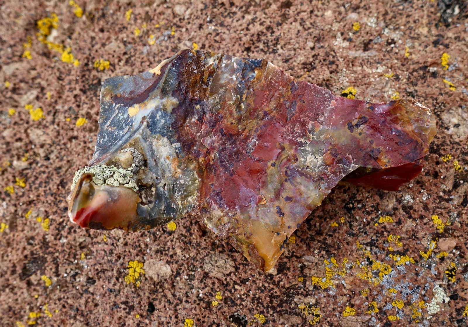
Also lying on the surface is an abundance of chalcedony, a microcrystalline form of silica created during volcanic activity. Some of the stones are translucent (agate) and others opaque (chert). Presumably, they were brought down from Boulder Mountain along with the basalt boulders. The wonder of this landscape expands with every step. Please allow these beautiful stones to remain on their home ground where you find them. (THW, photo)

Arrive on the ridge at 2.0 miles, 6,380 feet. This image looks north. To the east, irrigated hay meadows pull water from Boulder Creek, the larger of the two drainage systems. (THW, photo)

Point 6,590' is less than a mile afar to the south. The ridge is characterized by whimsical bumps, lumps, and blobs of stone that are great fun to scamper over. The ridge splits at a double-trunked ponderosa. Take your pick. The hogback on the east is more adventuresome than the mellow mound on the west. The north slope of the mountain is made of rock billows that come in scattered sets, some richly and deeply drenched in iron.

Point 6,590' has a sandy tabletop held down with ephedra and buffaloberry. Walk to the south vantage point at 2.8 miles for sweeping views of the Straight Cliffs and the astounding landscape extending south on the divide. The image below is muted by an overcast sky but you can make out the Cone, Point 6,534', and "Elongated Mesa."

The Cone, Point 6,534', Elongated Mesa, and Point 6,460'
Work your way down the south ridge of Point 6,590'. The slope is steep enough to get the boulder balls rolling. Friction pitches resolve in a maze of knobs and small domes. Weaving through or up and over the outcrops is hit and miss. Similar puzzling chaotica runs the length of the ridge from here--the explorer's board game.
Up next is the Cone, pictured image-right. You may easily bypass this feature on the east and head straight for Point 6,534'. However, the Cone is easily attained and there's a wild view back through the maze to Point 6,590'.
(THW, photo)

My favorite chunks of blended chert and agate reside on the south side of the Cone.
Point 6,534' is another sand-topped butte covered in piñon-juniper, prickly pear, narrowleaf yucca, a closely-packed field of ephedra, and claret cup cactus minutes away from blooming. From the south end at 3.7 miles, the ascent to Elongated Mesa appears complicated by an island of stone resting in the saddle, pictured. It is too exposed to circle around the base of the island. Rather, climb directly up the north ridge and flank the summit tower on the west.
Boulder balls hold the steep north slope of Elongated Mesa in place. The high point is at the north end at 6,500 feet. There were no signs of human passage across the 0.6 mile, deep sand flat. What's the difference between a mesa and a butte? A butte is taller than it is wide, and a mesa is wider than it is tall. (THW, photo)

To climb Point 6,460', descend on the south ridge of Elongated Mesa and then bear slightly southwest for the mellow ascent up the roller at 5.0 miles. If you are doing the north segment as an out-and-back, this is your turnaround. For variety, you can reasonably dodge the final ridge segment as depicted by the blue line on the map above. In April, gray cottonwoods striving to leaf, deep green ponderosas, and red-twigged willows formed a distinctive line of riparian color caught between great slabs of white sandstone. There are exceptional iron concretions on the lower level--some extruding from a stone drainage and even more forming linear fences.
Point 6,382' and Claude V. Cutoff to Highway 12
For those doing the thru-hike, the next prominence is Point 6,382', image-center. Your immediate goal is the saddle south of Point 6,460'.

The south face presents an impassable cliff. Therefore, you must drop back down the north ridge of the roller to elevation 6,320'. A tree heads a ramp leading to a high contour on the west side of the mountain. Flank the summit at the base of the upper cliff band. The footing is loose but exposure is mild. Descend on a rock rib to the saddle. This image was shot looking back at the south face of Point 6,460' and the obvious work-around on the west side.

Thru-hikers: If you are tapped, you can skirt Points 6,460' and 6,382' on the west. From the roller's north saddle, work your way down open slickrock to an elevation that appeals to you. This option is less taxing than climbing the two points but more tedious. You will need to locate the CVC south of Point 6,382' which may take some doing. A square-capped hoodoo resides a short distance west of the saddle. (THW, photo)

South of the saddle, the ridge constricts pleasingly. Perched on top is a most unusual grouping of large boulders made of concretions. The north ridge of Point 6,382' is a delightful sandstone step-up. The homey little butte is protected by a Class 2+ summit cap, shown. Check the integrity of your holds. There is some exposure and the stone is friable. Mount up to the most intimate and exhilarating prominence on the divide at 6.0 miles.

It is impossible to descend the almost vertical south face of Point 6,382'. The butte is bypassed on the east. Return as you came to elevation 6,220' and search for a break in the cliff band armoring the east side of the mountain, shown. The 6,200 foot contour works well for some distance. Wrap around to the south side of the butte. Boulder Creek is well below.

Intersect the CVC at a distinctive (and historic) juniper log fence on the ridgetop at a pass, 6.6 miles, 6,040 feet.
(THW, photo looking east)

The CVC is obvious at first because it is cleaved into the Point 6,382' runout slope, shown. As it continues south toward the Dry Hollow Creek crossing, it is easy to lose. There are subtle signs of very occasional use, a cairn here and there, rocks lining the trail. The path tracks slightly east of true south. On the east is a Navajo escarpment with slabs sliding down to the valley floor. To the west, you can see cars on the Hogback.

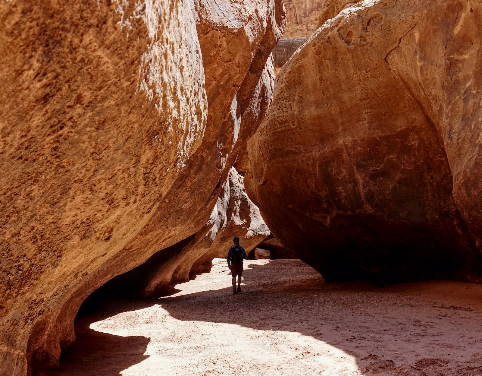
Ford Dry Hollow Creek at 7.6 miles, 5,780 feet. In April 2021, the three-foot-wide stream was flowing nicely. South of the crossing we found the first footprints of the hike. The track was easier to follow as it began the 460-foot climb to the Calf Creek-Dry Hollow/Boulder Creek divide. The old road is an engineering marvel. It plows through boulder balls and iron concretions. It is chiseled into bedrock hovering high above Dry Hollow. Big stones are piled on the precipitous edge to form a guardrail. Lacking maintenance, erosion is having its inevitable way and fallen rocks clutter the path. At 7.9 miles, cairns direct west for a steep shortcut route to Highway 12 at mile marker 78.1. I have not tested this option. Below, a hiker is starting down the CVC and Point 6,382' is image-center.

Top out on the broad ridge at 8.6 miles, 6,240 feet. From this overview, you will see the cleaved CVC, Dry Hollow, and the string of buttes and mesa climbed on the ridge traverse. (THW, photo)

Follow a single-track south-southwest across a sandy flat. Segue onto a jeep track 0.6 mile from the highway. (For those doing just the south half of this trek as an out-and-back, it's very easy to miss this turn onto the CVC trail while heading north. I made a visual indication of this location on the map above showing our own error.) The 4WD road bears east so you must soon leave it and head south. By now, you will see your vehicle. The CVC goes under power lines and then switchbacks to the southwest. The track makes a final turn to parallel the highway. Watch the surface for grooves in the slickrock cut by steel wheels bearing heavy wagon loads.

Climb 40 feet up a sandstone slope to your vehicle at elevation 5,940 feet. The image below was shot from the highway. It shows the CVC as it parallels UT 12, does a rising traverse up the hillside and switchbacks under the power lines.

Thank you Dan Honig for pioneering, and for sharing, this overland high-route through Dry Hollow.