Tuesday, November 30, 2021

Incinerator Ridge: Mount Bigelow, 8,540', to San Pedro Vista, Santa Catalina Mountains

Essence: Climb three peaks and two striking stone promontories on Incinerator Ridge east of the Palisade Visitor Center. The Bigelow, Kellogg Mountain, and Incinerator Ridge trails access the off-trail climbs. The hike begins from the Bigelow Trailhead, 600 feet higher than trail's end at San Pedro Vista. Drop a shuttle vehicle, or walk two miles up the Catalina Highway. The hike is on the far eastern perimeter of the Santa Catalina Mountains in the Coronado National Forest.
Travel: For the shuttle, drive up the Catalina Highway (aka General Hitchcock, Mount Lemmon highways) and leave a vehicle at San Pedro Vista on the right, Mile Marker 17.4. Continue up the highway, passing Incinerator Ridge Road and a sign for Palisade Visitor Center, 1/4 mile. Bigelow Trailhead parking is on the right side of the road at Mile Marker 19.5. If you come to Palisade, you've gone  too far. Pit toilet, picnic tables, no water. Fees were forgiven in 2021 but be ready to display your pass.
Distance and Elevation Gain: 5.2 miles; 1,350 feet of climbing
Total Time: 3:45 to 5:00
Difficulty: Trail, off-trail; navigation moderate; Class 2; no exposure (optional Point 7,820' is Class 3 with considerable exposure); carry all the water you will need; avoid when trails are snow-covered; thorns on Kellogg--wear long pants.
Map: Mount Bigelow, AZ 7.5' USGS Quad
Date Hiked: November 30, 2021
Quote: In things beautiful there is an eternity of peace, and an infinity of sight. John Alec Baker

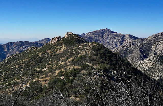
Incinerator Ridge has many stone nubbins and knobs that beckon playful hikers. The terrain drops steeply to the east, settling out in the vast San Pedro River Valley only to rise up once again into the Galiuro Mountains. 
(Thomas Holt Ward, photo)
 
Route: From the Bigelow Trailhead, hike north to the Mount Bigelow-Kellogg Mountain saddle. Ascend west to Mount Bigelow. Return to the saddle and climb east off-trail to Kellogg Mountain. Return once more to the saddle and walk southeast on the Kellogg Mountain Trail. Transition to the Incinerator Ridge Trail and ascend Incinerator Peak, Leopold Point, and Barnum Rock. Climbers may wish to scramble up Point 7,820'. Continue southeast and finish at San Pedro Vista.

Mount Bigelow, 8,540'
The Bigelow Trail bears north out of the parking lot, elevation 7,940 feet. The dirt path is softened by forest duff, stately ponderosa pines are generously spaced, the forest is uncluttered, and the grade is gentle. At 0.2 mile, the footpath turns sharply to the right, crosses a draw and ambles lazily up the forested slope.  Below, the communication towers on the summit of Mount Bigelow can be glimpsed at the start of the hike.

Weathered Catalina Granite boulders are dispersed amongst the trees. If you are a fan of granite, this hike is for you. It's in the center of a massive swath of exposed granite in the Catalina range. I fell in love with this trail as soon as I set foot on it and wondered how it took me so long to discover the sweet pathway.
  
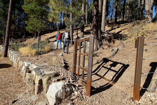
Arrive on Bigelow Saddle, 8,260 feet, at 0.6 mile. Three trails join in the saddle at a signed junction. The Butterfly Trail continues straight ahead, Kellogg Mountain Trail takes off to the east, and the Bigelow Trail cranks to the west/left. The treadway takes direct aim on the five red and white communication towers that completely take over the industrial summit. The trail ends at the road servicing the towers, 0.9 mile.

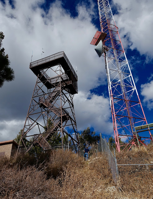
To reach the crest, turn right on the road. Just uphill from the fire lookout tower, a short trail climbs 20 feet to the summit. Reach the highpoint of the hike and only ranked peak at 1.0 mile. We were not able to find the benchmark referenced on the topo map and in Hike Arizona
 
With an 800 foot rise, Mount Bigelow is well positioned for a fire lookout. In July of 1926, the station reported a forest fire of several acres on the east side of the Galiuro Mountains. The current steel structure replaced the original wooden lookout in 1929. The tower is still used by the U.S. Forest Service as needed for detection. 

While Mount Bigelow feels like the busiest mountaintop ever, the vista from the service road is far-and-wide. Below, Incinerator Ridge dips down in waves from Kellogg Mountain. Retrace your steps to the saddle.
 
Option: Palisade Rock 8,310'
If you are curious about Palisade Rock as we were, start out on the trail toward the saddle. Less than a tenth of a mile below the road, leave the trail and descend south for about 200 feet over 0.1 mile on the rounded ridge, the blue-line route on the map above. The actual highpoint, shown, has a rise of 20 feet and is an easy scramble. It is at the north end of the bulbous outcrop overlooking the Palisade Visitor Center. 
 
Kellogg Mountain, 8,401'
From the saddle, it is only 0.2 mile to the summit of Kellogg Mountain with a 121-foot rise. According to past trip reports, there once was a beaten path along the crest of the west ridge. The landscape has been radically altered by the Bighorn Fire that scorched 119,987 acres in June and July of 2020. The fire spared the Bigelow Trail, Palisade Rock, and the summit of Mount Bigelow but it swept over Kellogg Mountain and Incinerator Ridge. The informal trail has disappeared from post-fire trauma and vicious thorny plants are unavoidable. However, the west ridge remains the only reasonable route to the top.

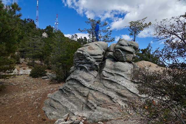
The crest of the unranked peak, 1.6 miles, is known for its tall summit cairns and westward lookout. Clearly, there is local affection for this little hill. The mountain is named after prospector Alexander Kellogg who had a cabin on the mountain in the 1890s. (THW, photo)

We found the No. 1 Kellogg reference marker placed in 1947, but not the benchmark. 
 
Incinerator Peak, Point 8,135'
Return down the west ridge and hike east on the Kellogg Mountain Trail, a half mile connector between the Mount Bigelow saddle and the upper end of Incinerator Road. The old trail with its stone retaining walls cut into the steep slope contours right under the south face of the mountain. My friend remembers lush green ferns and plentiful wildflowers. We were off-season for flowers but the trail had undoubtedly gotten more wild. It plows through the dreaded graythorn and brush tunnels. The pathway switchbacks down Kellogg's southeast ridge with an open view of the next wooded roller, Incinerator Peak.

Incinerator Road comes up from the Catalina Highway and intersects the trail system in the Kellogg Mountain-Incinerator Peak saddle at 2.4 miles. Technically, both the Kellogg Mountain and Incinerator Ridge trails begin here. Transition onto the Incinerator Ridge Trail which bears southeast to San Pedro Vista. There is dispersed camping and plenty of parking for those who want to hike in either direction from here. This was the location of an old dump and the namesake incinerator but we somehow neglected to search for either.
 
Just 0.1 mile further on is another sign at the start of the Knagge Trail that drops off the ridge to the northeast. For a detailed description of the trail and its history (The Knagges are a well-known Arizona pioneer family.), please link to Hike Arizona. The sign indicates Incinerator Peak is 0.4 mile afar. We glided over it effortlessly at 2.7 miles. The field of vision opens. To the west, look down on the heliport at Sollers Point and Rose Canyon Lake. And in the east, golden mountains flow into the San Pedro River playa. Leopold Point, image-right, is composed of a community of stone.

Leopold Point 8,060'
Leopold Point is just 0.1 mile off the trail with a rise of 80 feet. To make a small loop, leave the trail in the saddle and ascend on a social trail that wraps around the north ridge to the east side of the boulders before cutting back to the west. Or, you could simply take the westside trail to the summit. Either way, you'll be walking through avenues of towering boulders. Leopold was severely scorched by the Bighorn Fire but clusters of massive stone live on to gladden the hearts of visitors.

The summit, 3.0 miles, is a smoothly rounded rock plate whose vista encompasses an immense span. Nearby, Edgar Canyon cuts between Evans Mountain and a peak-studded ridge angling northeast and terminating at Davis Spring. Rising above all else is Mount Graham in the PinaleƱo Mountains. (THW, photo)

From Leopold, the northeast wall of Barnum Rock looks imposing and dramatic.
 
Barnum Rock, 7,954'
Back on the trail heading south, there are fabulous views of Leopold's southeast rockscape, composed of towering outcrops stepping down in succession. Backcountry camps are just off the trail in the Leopold-Barnum saddle. The main trail gains the north ridge of Barnum and then diverts to flank it on the west. Stay on the north ridge for the 174-foot climb to the rounded crown, shown. 

Barnum Point, 3.7 miles, is a rolling series of elevated slabs. We were ecstatic to be on this massive buttress. Climbers must agree because there are anchors all over the mountain. Look back on the four prominences climbed thus far.

San Pedro Vista and Optional Point 7,820'
To reach San Pedro Vista, retrace your steps to the trail. It curves to cross Barnum's south ridge in front of Point 7,820', shown. The half-moon edifice is an optional addition for experienced scramblers.

As shown on the map above, we left the trail once again to check out another nubbin to the southwest. There is exceptional rose colored quartz in this area. From the cap we got an enticing view of Point 7,820'. There are two routes up the aggressive monolith. My partner scaled the west ridge and a friend went up the north face. There is considerable exposure either way.
 
The west ridge is a Class 3+ scramble with a short razorback leading to the crest. 

The alternative approach is a friction pitch on the north face. I shot this on the downclimb.
 
This image was taken from the top of the point. I'm standing in the gap between the lesser outcrop and the main wall. (THW, photo)
 
The Incinerator Ridge Trail winds down fairly steeply on a rough, undulating track. We diverted a couple of times from the boulder staircase to check out appealing outcrops. This image looks back at Barnum Rock.

We had the trail and assorted, delightful offshoots all to ourselves even though the Catalina Highway was close by for the duration. Point 7,820' and Barnum Rock are visible from trail's end at San Pedro Vista, elevation 7,340 feet.

Saturday, November 27, 2021

Brinkley Point, 7,099', Pusch Ridge Wilderness

Essence: Brinkley Point is a solitary stone knob on the Sabino-Palisade divide. The hike begins on the Box Camp Trail and then diverts to traverse southwest on a wooded ridgetop out to the point. John Brinkley, a long-time ranger in the Santa Catalina Mountains beginning in 1945, is credited for creating the trail, now lost to time and neglect. This rugged hike of solitude leads to one of the most exceptional viewpoints in the range. Note that most of the elevation gain is accumulated on the return. The hike lies within the Pusch Ridge Wilderness and the greater Coronado National Forest.
Travel: On the Catalina (Mt. Lemmon) Highway, pass by the Palisade Visitor Center and begin a downhill stretch. The signed trailhead is on the left just past Spencer Canyon Campground, Mile Marker 21.4. The parking lot holds a dozen cars. No facilities, no fees, no water, no dogs.
Distance and Elevation Gain: 7.2 miles; 2,050 feet
Total Time: 4:45 to 5:45
Difficulty: Trail, off-trail; navigation moderate; Class 2+; mild exposure on the summit block; hike on a cool day; carry all the water you will need; brushy, wear long pants.
Maps: Mount Bigelow; Mt. Lemmon, AZ 7.5' USGS Quads
Date Hiked: November 27, 2021
Historical Note: In 1948, John Brinkley married a young woman who lived in Tucson but often stayed at one of the three cabins in Summerhaven. They lived at the Palisade Ranger Station and on the Mount Bigelow Lookout Tower. Brinkley gave his life to the range; he knew every canyon, every rock. But he never walked if he could ride a horse. The story goes that he built the trail and rode out to Brinkley Point frequently. While his trail is gone, you will likely find evidence of log cutting to clear a passage for his mule Bea or his horse, Lucky. (Bowden, Charles. Frog Mountain Blues. The University of Arizona Press, 1987.)
Quote: Without the Santa Catalina Mountains, Tucson is just another city in a nation of urban islands. We do not know who we are until we look at the mountain. We have not been able to resist our hunger for the huge stone wall that frames our lives. Charles Bowden

Brinkley Point is a weathered block of Catalina Granite. The land drops radically away from the spectacular viewing platform. Look deeply into Sabino Canyon and its tributaries, and upwards to the fractured and remote peaks of the Santa Catalina Mountains. (Thomas Holt Ward, photo)

Route: Descend southwest on the Box Camp Trail to the junction with the Box Spring Trail. Head northwest through Box Camp to the Sabino Canyon divide. Leave the trail and ascend west over Point 7,529'. At about 7,240 feet, transition west to stay on the primary ridge. Hike southwest, passing over Point 7,185' and on to Brinkley Point. 

From the trailhead on the north side of the parking lot, elevation 8,020 feet, the pathway climbs gently west while contouring below Spencer Peak. The land and our experience of it has changed markedly since we hiked the Box Camp Trail in March, 2020. I wrote, "Thriving in the Montane Fir and Pine Forest life zone are Arizona pine, southwestern white pine, Douglas fir, white fir, and gambel oak. The trees are big, the air is cool." Tragically, in June of that year, a lightning strike ignited the Bighorn Fire on Pusch Ridge. By July, it had incinerated 119,987 acres. The fire roared through this region scorching patches of forest and leaving green crowns elsewhere. 

The trail weaves through a community of weathered Catalina Granite boulders, hard to the touch but soft in form. They reminded us of the block fields seen within the Wilderness of Rocks at roughly the same elevation on the north side of Sabino Canyon. 

Cross into the Pusch Ridge Wilderness at 0.3 mile. Rise up to 8,120 feet and then begin the descent to the Box Spring Trail. To the northwest is Cathedral Rock, Wilderness of Rocks, Marshall Peak, Lemmon Rock Lookout, and Mt. Lemmon's westward ridge. 

The footpath rolls off the ridge to the north and crosses a fork of Palisade Canyon at 1.1 miles. Monkey flowers were blooming in moist soil in late November. The channel drops, rocks with veins of quartz and banded gneiss step down, and water spills in small cascades. The fire swept through the gorge and damaged our favorite double-trunked alligator juniper.  

The route to Brinkley Point utilizes a small stretch of the Box Spring Trail. The junction at 1.8 miles, 7,520 feet, is not marked with a sign or a cairn. Post fire, the path is so subtle we blew by it once and could easily do so again if distracted. The secondary trail drops off to the right, northwest.

The trail passes through a pine flat, site of the old Box Camp, named by early trail users who nailed boxes to trees for storage of food and other goods on trips into the high country. It is located on a large, pleasant flat with big views through the trees. The Bighorn Fire ravaged Box Camp. See the Box Camp Trail post for a contrasting image.

The pathway beyond Box Camp is easy to lose. Walk northwest, cross the Palisade tributary at 2.0 miles, and ascend to a low saddle on the Sabino Canyon divide (elevation 7,380 feet), less than 0.1 mile beyond Box Camp. If you are considering a side trip to Box Spring, I must caution you. The trail is gone and the tangled brush is almost impenetrable. 

The route to Brinkley Point is 1.5 brushy, off-trail miles from here. To start, bear west out of the saddle and climb over Point 7,523'.

Go over or around the globular behemoths on the undulating ridgetop.

Views from the divide are enthralling. This peninsula of stone is suspended 900 feet above Sabino Canyon. 

Ascend over this roller, a landmark indicator that the ridge transition is imminent.

Top the bump at 2.5 miles and get a good look at Brinkley Point's location on the primary ridge. The current ridge fades as it drops off to the south. We left the ridge at 7,460 feet and descended to the right/west, losing a good 200 feet. It's not critical where you initiate your transition but do so by 7,400 feet. It is a fairly steep pitch through a forest of Arizona alligator oak. Below, my friend (small figure, pink hat) is standing where he left the ridge crest.

Follow the primary ridge the rest of the way out to the point. At 2.7 miles, we actually stumbled on brief remnants of Brinkley's trail. Climb over Point 7,185' (where the feature image at the top of this post was shot). Descend to the saddle at 6,940 feet, giving Brinkley Point 159 feet of prominence.

Large quartz chunks have eroded from the intrusive igneous granite. The stone sphere sparkles with crystals. The standard route to the cap is on the north side. 

Exposure is mild while climbing the natural staircase. 

Surmounting Brinkley Point is intense, exhilarating, and unexpected. Land just falls away to reveal an intimately familiar landscape from an entirely new and lofty perspective. Below, I'm on the tipoff looking at Thimble Peak and Blacketts Ridge strung above Sabino Canyon. The sky was lamentably hazy. (THW, photo)

It took us 2:20 to cover the 3.6 miles out to the point which is typical. Elevation gain was 450 feet, less than a quarter of the total. Brinkley doesn't get a lot of visitors; only three parties signed in 2021, including the Huachuca and Green Valley hiking clubs. 

Curiously, the benchmark claims the elevation is 7,073 feet. But the Mt. Lemmon USGS topographical map pegs it at 7,099 feet, the accepted height. 

A great mass of neighboring rocks tempt as the ridge plummets to the West Fork of Sabino Canyon. On the other side of the trench are McFall Crags and Rattlesnake Peak

West is Sabino's headwater canyon, Lemmon Canyon, the ridge bearing the Mount Lemmon Trail, and of course, Cathedral Rock.

According to Charles Bowden, Ranger Brinkley had a sixth sense for the Catalinas. When people got lost in the mountains he would direct the search party or find the lost person while Search and Rescue was still getting suited up in Tucson. This image looks back on the undulating access ridge with Sabino Canyon to its left. I like the idea of honoring John Brinkley by walking in his footsteps, or rather in the steps of his steeds. (THW, photo)

Tuesday, November 23, 2021

Point 5,389' (Molino North) and Point 5,260'

Essence: Climb two unranked stone prominences northeast of Molino Basin. Scramble up a meandering ridge to Molino North. Route finding through a disordered rock garden is challenging on a small scale. Let the boulders guide and enchant. Don't neglect the captivating, brief scramble up Point 5,260', a ragged rock kingdom. Brief descriptions of Point 5,808' and Molino South are included. The hike is within the Coronado National Forest.
Travel: The Molino Basin Trailhead is at Mile Marker 5.6 on the Catalina Highway, aka Mount Lemmon Highway and General Hitchcock Highway. Mile Marker Zero is posted at the junction with Mount Lemmon Short Road. The Molino Basin Campground and trailhead parking is located on the west side of a sweeping turn. Pit toilet, no water. No fee required for hikers on the Arizona Trail (AZT).
Distance and Elevation Gain: 4.3 miles; 1,500 feet for both prominences
Total Time: 4:00 to 5:00
Difficulty: Trail, off-trail; navigation challenging; low Class 3 with mild exposure; wear long pants to guard against brush and Arizona blazing star (velcro plant).
Map: Agua Caliente Hill, AZ 7.5' USGS Quad 
Date Hiked: November 23, 2021
Poem:
Till the very end of time
   matter will always remain young,
      exuberant
         sparkling
            new-born
for those who are willing.

Teilhard De Chardin

Point 5,260' beckons from the ridge leading to Molino North. We hadn't planned to visit the stony summit but we couldn't resist its allure. It was by far our favorite spot. (Thomas Holt Ward, photo)

Route: Hike east on the AZT to Pass 4,860'. Ascend north on a social trail to a knoll at 4,900 feet. The route is off-trail from there. Follow the ridge as it swings in an arc northeast and then northwest to Molino North. To climb Point 5,260', hike southeast to the south ridge and scramble north to the summit. The red-line route is an optional bushwhack to Point 5,808'. The blue-line route follows a well-established social trail from the pass to Molino South, Peak 5,166'.

Cross the highway while watching attentively for vehicles and bicyclists rounding the corner at speed. From the Molino Basin Trailhead, elevation 4,370 feet, hike east on the AZT. Below, from left to right is Molino North, the pass, and Molino South.

Cross the Molino Canyon wash and begin winding upwards on a beautifully engineered trail composed of crushed granite and block steps. The trail is popular with day hikers, AZT backpackers, and mountain bikers linking with the La Milagrosa Trail. In late November, only turpentine bush was blooming amongst beargrass, yucca, sotol, pricklypear, shindaggers, and manzanita. Gain the 4,860-foot pass at 0.9 mile. (This is the launch point for the short hike up Molino South referenced at the end of this post.) For Molino North, locate a faint path on the west side of the gate and bear north. Below, Airmen Peak and Point 5,820' are image-left and Molino North is center-right.

The helpful trail ends on a knoll at 4,900 feet. Pause and consider your route options up and through a cluster of rock stacks, crags, and broken cliffs, shown. This is the most challenging segment on the route to Molino North. On our ascent we were too far to the west and encountered stiff Class 3 moves. On our return, we found a more reasonable zig-zag route east of the center. The intrusive granite has helpful, sticky features. Initially, cross over a barbed wire fence and then somehow or other work your way up through the rock.

This close-up image of the initial challenge is illustrative of the geology seen on this hike. The Santa Catalina range is an uplifted and highly eroded dome of sedimentary, igneous, and metamorphic rock. The most common rocks on the forerange where this hike takes place are gneiss (near the highway) and Catalina Granite (throughout). The granite originated 26 million years ago as a rising mass of molten magma that cooled well below the surface. Prolonged cooling allowed crystals to form giving the granite its sparkles and pegmatitic texture. Resistant remnants of bedrock remain on the surface as erosion wears back the mountain front. Weathering and erosion have enlarged sets of vertical and horizontal joints, dividing the bedrock into individual blocks. Weathering widens and deepens the joints and rounds the corners and edges of the blocks.  ("A Guide to the Geology of the Santa Catalina Mountains, Arizona: The geology and life zones of a Madrean Sky Island." Arizona Geological Survey, Down-to-Earth, #22, by John V. Bezy, 2016.)

(THW, photo)

Once through the rock band, follow the winding ridge northeast. 

As the ridge begins to swing north, make a short hook south to a broad-ranging vista point. Molino South is featured below. 

"Go up the ridge, you can't miss it," quipped a friend. This garnered some laughs because the ridge is rather complicated and it pushes you around. Weathered granite outcrops and playful scrambling are consistent features. 

The ridge pivots northwest and makes for the crest, the rounded prominence image-left. 

Arrive on Molino North at 1.8 miles The peak register is tucked under the summit boulder. Point 5,389' doesn't see a lot of visitors--just a couple of parties sign in each year. (THW, photo)

The tip top of the point requires a Class 3 move. It was a stretch I couldn't span so I needed a boost. 

Look far and wide past the home front or simply down on the Catalina Highway curving through Molino Basin. On the other side of the highway is another of our select, low elevation favorites, Peak 5,471'.  If you are not going on to points 5,808' or 5,260', simply retrace your steps. (THW, photo)

Point 5,808'
My partner climbed Point 5,808' in spring, 2021, the red-line route on the map above. It was my intention to replicate that hike but I couldn't generate much enthusiasm. The prominence looks impressive from Point 5,389', but in reality, it is an unranked roller on the southwest ridge of Guthrie Mountain (Peak 6,466'). This is a troubled altitude for brush, particularly oak. He reported the climb was good until half way up and then it was hideously tangled and not worth it. If you have a better experience or route, please leave a comment for all of us. It is 1.5 miles with 950 feet of vertical, roundtrip.

Point 5,260'
Instead, we succumbed to the power of exploration amongst the standing rocks on the neighboring prominence to the southeast. We had no idea if we could find our way to the crown. We left our upcoming ridge where it pivots to the south and descended easily to the saddle at 5,140 feet. 

We made a direct approach by walking through bulky columns to the base of the cliffs where we found anchors and climbing chains. We probed, got repelled and pinched, and backed out. Eventually, we found a route to the south ridge. Looking at the image below, start by ascending just to the left of the free-standing square tower, image-right. 

You will see a break in the cliffs. Descend about 50 feet to the base of the climbing zone, shown. Scale southeast to the ridge, gaining it at 5,220 feet. 

The low Class 3 passage to the north is unmistakable.

The extraordinary, pure-stone summit is to the west at 2.5 miles. We felt a sense of elation that the little mountain permitted us access. As peaks go, this is one of the best. 

A weathered, old rock creature lies in recline mimicking the mountain-topped ridges to the east--Agua Caliente Hill and Mica Mountain.

We looked down on the pillars we'd probed earlier, awed by their complicated and wild nature and our successful trip through the maze. (THW, photo)

We could see two sets of chains buckled to the shorter companion tower (image-left) but getting there was risky. Return to the pass at 3.4 miles. (THW, photo)

Peak 5,166' (Molino South)
If you have not yet climbed Molino South this is a superb opportunity. It is only 0.3 mile with 366 feet of rise to the highest point on the Molino-Agua Caliente divide south of the Arizona Trail. For a more elaborate description, follow the link given at the top of this post. In brief, the south spur to the peak begins east of the gate. The start of the footpath is deliberately obscured by slash. Once past the initial obstruction the trail is clear. The slim path is all business, kicking steeply up the north ridge to the summit. Molino South looks downright impressive when viewed from Point 5,260'. (THW, photo) 

Hitchhiking velcro-plants (Arizona blazing star, Mentzelia isolata) were particularly bothersome in November, 2021. Denim jeans and cotton shirts are best suited for repelling the pesky plants. Rattlesnakes are common in this area. Snakebite guards afford good protection.