Thursday, September 25, 2014

Capitol Reef National Park: Lower Muley Twist Canyon via Cutoff Trail

Essence: Everything about this hike is oversized: the miles, the plentiful and enormous alcoves, and a spectacular wall that holds the Earth down for 2.5 miles.

"Fortress Wall" with 1,000 feet of relief--soaring, smooth, and shear. This is the hike's Grand Prize.

Travel: Zero-out your trip meter at Capitol Reef Visitor Center. Drive east on Utah State Hwy 24 for 9 miles to the Notom-Bullfrog Road. Go right/south. The first 11 miles are paved. The road is dirt the rest of the way and can be impassible when wet. Seriously. The track parallels the 100 mile long Waterpocket Fold on the east side. Pass the Cedar Mesa Campground at 31 miles and the Burr Trail Road at 43 miles. The Post is 2.3 miles past the Burr Trail turnoff. Go right/south. The turn is labeled, "Lower Muley Twist Trailhead." Drive one more mile to a large parking area at 46 miles. Allow 1.5 hours from the Fruita Campground. 4WD, high clearance recommended. Fee Information. Park facilities are open year-round.
Fruita Campground: This idyllic, shady campground is adjacent to the Fremont River, tucked amongst historic fruit orchards. In 2018, the campground initiated a reservation system. The 71 sites are first-come, first-served November through February. There are bathrooms, fire grates, picnic tables, and water.  Campground information.
Cedar Mesa Campground: Located 22 miles south on the Notom-Bullfrog Road. Five sites with picnic tables, grills, outhouse, no water.
Distance and Elevation Gain: 16.8 miles (16.4 without side canyon exploration), approximately 1,000 feet of climbing
Total Time: 7:00 to 9:00
Difficulty: Trail, cairn, and canyon-bottom route; navigation is moderate but critical; brief, mild exposure on Cutoff Trail; carry all the water you will need; do not attempt this hike during or soon after significant rain.
Maps: The Post, UT 7.5 Quad; or Hiking Map & Guide: Capitol Reef National Park; or Trails Illustrated: Capitol Reef # 267, available at the Visitor Center, open daily, 8:00 to 4:30
Date Hiked: September 25, 2014
Quote: When you truly understand one thing--a hawk, a juniper tree, a rock--you will begin to understand everything. Ellen Meloy, Eating Stone

Route: Traverse Lower Muley Twist Canyon as a long day hike. From TH 4,851', go west on the Cutoff Trail over Waterpocket Fold. Intersect Lower Muley four miles south of the top of the Burr Trail Road switchbacks. Hike south until the canyon turns east and pierces Waterpocket Fold. Upon emerging from the narrows, follow the north-trending route back to the trailhead.

Trailhead 4,851', is located at the Post Corral on Halls Creek bottomland.

From the parking lot walk south to a sign, gate, and trail register.

Following the sign to Lower Muley Twist, go due west. Cross Halls Creek, quite possibly a muddy proposition. The sandy path is marked with white posts that lead directly to the stoney base of the Fold.

Follow well-placed cairns up a red ramp of Carmel Formation and onto white Navajo Sandstone.

While the route wiggles around a convoluted and contorted landscape, it heads solidly west. The way is delightfully unpredictable, revealed as you go. It is steep in places and there are a couple of mild friction moves. Generally, exposure on the Cutoff is overstated in the literature. What is understated is just how fun it is. I could happily do laps up and down the Fold all day.

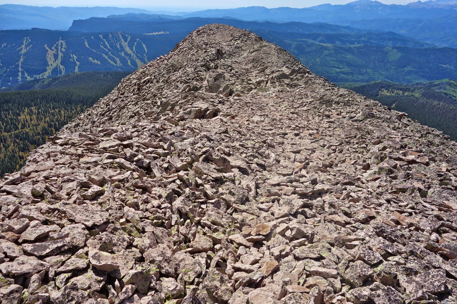
Climb three ridges on the way to the highpoint at 5,488 feet. One of the great charms of this hike is climbing to the top of the Fold at the beginning, and cutting through it at the end. Scanning the landscape, there are other likely places to reach the top of the Fold from the east. However, descending to the west is another matter. The Cutoff punches through a rare weakness in the reef seen below. Brick-colored Kayenta Sandstone is on the other side of Lower Muley Twist Canyon. From the high point, the path drops into a sandy area where it becomes braided and spotty. Just get through the break to a small side canyon.


Go left downcanyon, following cairns to Lower Muley where there is a sign at 2.2 miles.

Walking is fast and easy on a (post-rain) firm, uniform washbed. Four days prior to our hike, the wash flashed three feet up the walls. Just beyond a side canyon, downcanyon-right (DCR), is the first of many massive alcoves characterizing this canyon. Some undercut alcoves are so deep, to enter is to walk into the night. Big ceiling blocks are piled up on the floors. Echos bounce off the opposite canyon wall. Sandstone walls grow ever higher, colors soft.

A coral-streaked alcove is at 6.8 miles and just beyond house-size blocks confound the washbed. They are cubical, sharp edged with 20 foot drops. A time-consuming, complicated, try-this-and-that approach, led to a climb-down. There were no cairns; take your time and you will find a way.

Fortress Wall appears first as a monolith. But no, it is a continuous wall that stretches on for 2.5 miles on the east side of the drainage, all the way to the canyon's easterly turn where it encases the narrows. The rock is Wingate Sandstone, a prominent cliff builder.

The river meanders but the straight wall continues.  A notable exception is a crimp forming an 80 foot-tall dam.

Fortress Wall, the predominate feature of this hike, is reason enough to walk many miles. The mighty wall evokes a sense of awe and primal emotion. In its presence, I had a strong feeling of protection. It takes up the entire eastern view from north to south and you have to crane your neck to see the top, 1,000 feet straight up. Truly, it is one of Earth's greatest creative masterpieces. In this typical image, water undercut an alcove at the wall's base.

Cowboy Cave is at 9.8 miles, DCR.

In the 1920's, cowboys carefully printed the inscriptions. These men probably did not get much schooling. Charlie Baker has an extra "L" in his name and Andrew Hunt writes his "N's" backwards. A few historical artifacts remain.

At 10.4 miles, explore a deeply sculpted and colorful side canyon, DCR. Tafoni-infused wall textures are almost freaky. We turned around 0.2 mile up at a wide opening revealing the Circle Cliffs.

At 11.0 miles, (10.6 without the side canyon), Fortress Wall swings east, bringing Lower Muley along with it.

Actually, the canyon's wash carved its way through Waterpocket Fold. Enter the narrows, the passage through the stone. While it is not super dramatic, it is quite lovely. The walls are Wingate smooth, and there's a feeling of intimacy and comfort.


As you exit the narrows, at approximately 12.0 miles, the Strike Valley cliffs are visible ahead. Very shortly, within 0.2 mile, a cairn on the left/north signifies the route out of the wash. If you miss the exit, in about 0.5 mile, you will come to Halls Creek. Turn north there. 

The trail makes a shallow climb and in 0.1 hits an old road. The final trek to the trailhead is fast walking on a mix of trail and barely discernible road. The track is either distinct enough or well-cairn'd all the way back. Waterpocket Fold is once again visible to the west. The northerly segment, not quite 5 miles, takes less than two hours.

The track crosses Halls Creek several times. Generally, it is a simple crossover. Only once will you drop into the wash and go around the bend before a cairn marks the way out. At 15.4 miles, the trail to Cottonwood Tanks veers left. I have not checked for water viability but hear it is usually reliable. The image below is the final Halls Creek crossing, 0.6 mile from the trailhead.

On April 24, 2016, we hiked downstream in Lower Muley Twist Canyon starting from the top of the Burr Trail Switchbacks. We did an eight mile out-and-back to the junction with the Cutoff Trail. There are two sets of short, low-wall narrows. Walk in a sandy channel with softly sculpted orange-salmon sandstone banks.


Saturday, September 13, 2014

Grayrock Peak, 12,504', and Graysill Mountain's Southern Points

Essence: Humble in height, Graysill Mountain makes up for it by going on forever. Approach from the southwest. Cross The Divide between Hermosa Creek and Cascade Creek drainages to reach Grayrock Peak. Then explore four distinct southern points of Graysill. The bulk of this hike is off-trail on talus. Watch for mighty elk herds.
Travel: From Durango, drive north on US 550 for 28 miles to Durango Mountain Resort. At mile marker 49, turn left. Zero-out your trip meter and advance up the paved, ski area road.  At 0.3 mile, turn right on Hermosa Park Road, #578. There is a small, brown sign marking this dirt road. A washboard-worthy 2WD should be able to reach the TH. The road, graced by aspens, makes three big switchbacks. Little spurs head off; the main road is obvious. At 3.2 miles, go right, staying on Hermosa Creek Road. At 3.6 miles turn right on Relay Creek Road, #579. Stay straight at 4.8 miles as Cascade Divide Road goes off on the right. (It serves the Pando Creek approach to Greysill.) Continue your passage on #580, contouring through aspens with occasional views of the day's quest and the Hermosa Creek Valley way down below. The East Fork of Sig Creek passes under the road through a culvert. Travel under Pt 12,007'. Park at 11.0 miles in a very large lot on the right. Allow 1:00 from Durango.
Distance and Elevation Gain: 8.4 miles, 2,900 feet of climbing
Time: 5:30 to 7:00
Difficulty: Abandoned road, off-trail; navigation considerable; mild exposure on The Divide and on Pt 12,007'; significant portion of route is on talus
Maps: Hermosa Peak; Engineer Mountain, Colorado 7.5 Quads
Date Hiked: September 13, 2014
Quote: Is a mountain only a huge stone? Is a planet an enormous mountain? Stanislaw Lem, Solaris

Grayrock Peak, left, and Graysill Mountain as seen from the ridge south of Jura Knob. Cascade Creek is down in the trench.

Route: Two standard routes service Grayrock Peak, the one described and Pando Creek. The mountain is immense. Use the Pando access to see Graysill's east side and to explore to the north. Our stem and loop route lends itself to roaming along the southern points. Approached from the southwest, the semi-flat mountain feels even more like a world unto itself.  Begin on an abandoned road before surrendering to a day in the talus, broken infrequently by patches of tundra. 

Trailhead 10,400' is marked by two road-blocking boulders down off the north side of the parking lot, hidden at left. This image looks back on the incoming road.

Go north on the moss and grass covered track with little evidence of use as it passes through an unhealthy fir forest. Follow the road intuitively and you will stay left at 0.3 mile and again at 0.5. At 0.7 mile, cross a rivulet. At 0.8 mile take the right fork.

Climbing gradually, the road becomes over-grown and indistinct as it nears a clearing below two points. "The Triangle" (as it appears on the 7.5 topo map), will loom to the east.

Point 11,663', pictured, a rounded form with patches of trees, is north. At 1.3 miles, 10,900 feet, stand in the heart of the clearing (N37 40.479 W107 53.360). It is a peaceful place of solitude. Imagine where Saddle 11,550' will be (center of image below), the next goal. Wend a course through small openings, stumbling on intermittent social and game trails. Cross an old road.

Find the golden path between the base of Point 11,663' and the forest. This couldn't be a sweeter lift to Saddle 11,550' at 1.9 mile.

At the saddle, a new world opens with Hermosa Peak shown, center left, and Lizard Head on the right. The saddle is disorienting with the land dropping decidedly off to the north. Where's the mountain? Turn right/east, rising gently in the woods. Clamor over deadfall for a brief time.

Hold a direct east bearing while ascending to 11,800'. At 2.4 miles emerge on tundra (embrace it!) in the krummholz. The mountain is on the horizon laying low like a gray whale. Continue walking due east, aiming for the base of the ridge.

There are startling views southwest to the La Plata range, the three mile knife of Lewis Mountain, visible. The image below features Point 12,007', to be scaled later in the hike.

At 2.7 miles, 12,120 feet, reach the eastern edge of Graysill; the Cascade Creek drainage lies below. This is where the Pando Creek access joins our route. Turn south and begin a talus ascent on a rounded ridge; soon it becomes more distinct. Reach an overview at 2.9 miles, Point 12,380 feet. From here you can see the thin Divide leading to Grayrock Peak. Below, Engineer Mountain lies close by to the east. Grayrock's prominent rock glacier spills off the mountain.

In the image below, the highest point on the horizon is Grizzly Peak and to the left of it is Sliderock Ridge. Pando Creek is in the foreground.

The Divide is one of the greatest features of this hike. The thin line straddles the Hermosa Creek drainage to the southwest and Cascade Creek drainage to the northeast, both, massive water carriers.

The Divide is a place of great drama, but exposure is not a factor for most people. It narrows to eight feet wide. Walk across on teetering plates.

As the ridge melds into Grayrock, the grade increases briefly. Near the top a social trail skirts right of jumbled rocks on the ridgeline. The ridge ends abruptly on an exceedingly broad, tundra covered, almost flat summit that goes on and on.

The register is located in a rock pile east of a major bivouac at 3.6 miles. (The register was gone in 2019.) For those familiar with these mountains, the crest is at the center of the known world. Spin 360 degrees. This is the middle ground between the La Plata and San Juan ranges. See the grand sweep of the Colorado Trail connecting the two. Blackhawk Mountain is the big hulk nearby to the northwest. Skiers at Purgatory see Grayrock all day long; now you know why.

Many people climb mountains simply to reach the summit. The quickest return is to retrace your steps to the trailhead. However, if the weather is good and you wish a better understanding of this landscape, continue on the loop. And while it is admittedly a gray world, the exploring is bright and cheerful. So, from the summit, walk south to Point 12,440'. This is straightforward and fun.

Look west to locate the second southern point, shown at the far left in this image. Return to the crest and walk back across The Divide on trickster, teeteree totteree talus.

Past the Divide, go southwest across this forever landscape to the very southern edge of the massive platform at 4.9 miles, 12,280 feet. The talus in this area was laid by a more competent stone mason and is rather accommodating to the walker.

From the second southern point, go west and work down a steep but manageable slope, aiming for the base of the Point 12,007' ridge, shown. Turn south and climb a small knoll. The boulders on the other side will wreak havoc with your sense of balance. Climb the ridge to Point 12,007'. It steepens and narrows the higher you get. Rocks are loose. There is mild exposure so if that's not your thing, take a pass on this optional spur to the third southern point.

Reach the top at 5.6 miles. The six foot cairn identifies Point 12,007' from afar. This image looks back on Point 12,440' and Point 12,280'. Return from this out-and-back at 5.9 miles.

The final southern point is The Triangle, 11,840 feet, a small, worthy diversion. The way is clear.

Plot the homeward course from here. Look down on the clearing at the end of the road from this vantage point. You could conceivably return by way of Saddle 11,550'. We contoured northeast 0.2 mile and then down a gradual slope on a slight bench another 0.2 mile to the trees. Relaxing on the grass at 6.5 miles, my hiking partner said, There's not a soul anywhere out here except for us, the birds, the wind in trees.

To reach the clearing, drop southwest 0.4 mile to a faint roadbed. Go right for 0.2 mile to the incoming track. Go left, reaching to the clearing once again at 7.1 miles. Follow the road back to the trailhead. Returning on the Relay Creek Road, puzzling Graysill will make more sense. Point 12,007' is left, Point 12,280' center, and Point 12,440', right.


Wednesday, September 10, 2014

Mountain View Crest to West End: Overlook Point, 12,998'; Peak 12,740'

Essence: Miles fly by; walking is undemanding on tundrascape to the west end of Mountain View Crest. Spires of the Needle Mountains mesmerize. Heart-stopping view of the audible Animas River 4,300 feet below. Along the way, climb over two ranked peaks.
Travel: From Durango, drive roughly eight miles north on US 550 to the signal at Trimble Lane. Zero-out your trip meter as you turn right/east. Turn left on East Animas Road, CR 250, at 0.8 mile. At 4.0 miles, make a shallow right onto Missionary Ridge Road, La Plata CR 253. The road is good, though prone to washboard. Passage is on a mild shelf for miles. At 16.0 miles go straight toward Henderson Lake on FSR 682. At 22.7 miles go right on FSR 081. Immediately, pass Henderson Lake. The road gets rougher and steeper but is plausible for 2WD vehicles with moderate clearance and sturdy tires. Park at 25.9 miles (elevation 10,940 feet), just before the road degenerates substantially as it continues another two arduous miles to the Lime Mesa TH. Allow 1:00 from the bottom of Missionary Ridge Road. If you wish to start hiking from the Lime Mesa TH (blue-line route below), see the travel and initial route directions for Mount Kennedy and Aztec Mountain.
Distance and Elevation Gain: 14.0 miles; 3,400 feet of climbing
Time: 6:30 to 8:30
Difficulty: Trail, off-trail; easy walking with two slightly more demanding segments; navigation moderate; no exposure
Map: Mountain View Crest, Colorado 7.5' Quad
Latest Date Hiked: September 19, 2020
Quote: Beauty beyond thought everywhere, beneath, above, made and being made forever. John Muir

The author strides happily along the relaxed edge of Mountain View Crest ever mindful of the stark contrast Pigeon Peak and Turret Peak present across cavernous space. (Chris Blackshear, photo)

Route: Mountain View Crest is a landform that rises steadily from the south and tops out at an abrupt escarpment that runs roughly east/west for almost ten miles. It extends from Columbine Pass on the eastern side to a definitive end on the west, hung high above the Animas River. The Needle Creek drainage defines the bottom of the abutment on the north side. This tour covers the western half of the vast sublimity. For the eastern portion, see Mount Kennedy and Aztec Mountain.

The Lime Creek Trail conveniently bisects the crest near the midpoint. The last portion of the road to the Lime Mesa TH is so demanding, only serious 4WD vehicles are capable of arriving. We stumbled on the idea of stopping short a few years ago and made our own route to meet up with the Lime Mesa Trail. Others have followed and the alternate trail is fairly well established. 

Park and walk 0.3 mile up the road until it hooks a sharp right. At the apex of the bend, look for a trail leading off to the left/northeast at 11,040 feet.  If you lose the trail, no worries. Just keep Lime Mesa's west face cliffs on your right. Red cubes fallen out of a low-lying wall rest beside the trail. We made up a new word to describe this phenomenon that carries on for some distance: Cubular. 

The path rises gently through clearings and woods for 1.9 miles. Then, in the tundra, it holds a northeast bearing until it intersects the Lime Mesa Trail at 2.4 miles, just shy of 12,000 feet. A large cairn marks this junction at the north end of Lime Mesa. Look south and see Dollar Lake 0.6 mile away.

Turn north, staying on the distinct Lime Mesa Trail while climbing through an enchanting amalgamation of tundra and granite.

The escarpment's precipice doesn't reveal itself until you are standing quite near the edge at 3.6 miles, 12,520 feet. Pigeon, Turret, and Mount Eolus, 14,083', take a mighty big cut out of the sky. An angler's trail dives off the crest to Ruby Lake nestled in a cirque below.

The next 3.5 miles to the west end is off-trail. Occasionally there are social and sheep trails but they are rather unnecessary. The land slopes softly on the south and loses itself to thin air on the north. Walk the edge.

From the Ruby Lake overview, turn northwest and climb a welcoming slope, passing a gigantic cairn. The shifting view is gripping, often compartmentalized by granite walls enclosing couloirs. This image of Ruby Lake was taken from the initial incline. (THW, photo)

Point 12,802' is easily won. This is one of those unusual hikes where 14 miles feels like half that. There are only two tricky places and one of them is on the west side of this point. Scamper down a talus field 150 feet. The crack off the nose is the most fun.

From the saddle, it is a quick climb with no interference to Overlook Point, 12,998', a ranked peak, at 4.5 miles. The left side of this panorama highlights the Needle Range. Just right of center are the mountains on the east side of the crest: Kennedy and Aztec. West Silver Mesa's granite sheets gleam in the distance. Ptarmigans reside on this peak so keep a sharp eye out for these elusive, camouflaged birds. (THW, photo)

The northwest side of Overlook Point delivers up a talus field followed by a steep drop down a grassy slope punctuated by weathered boulders and crushed granite underfoot. In the saddle, a hiker looks down on Pear Lake.

The next crest on the ridge is Peak 12,740' with 320 feet of rise, shown. It is easily scaled and affords a look at Webb Lake residing on a bench below. (THW, photo)

The Mountain View Crest 7.5' USGS topographical map identifies the next roller as Needleton, 12,719'. Most people think of Needleton as the train stop for the trek to Chicago Basin on-level with the Animas River. The walk to this upper story Needleton is magical. This image shows the west ridge extending from Needleton, the high point on the right. (THW, photo)

Weave between weathered granite blocks embedded in a tundra cushion. Arrive on Point 12,719' at 6.2 miles. We anticipated, but could not locate a benchmark on the crest.

From this lofty perch, look down on the Animas River. Or, look east up Needle Creek and find Chicago Basin, base camp for Eolus, Windom and Sunlight peaks, shown. (THW, photo)

Mountain View Crest makes a bend at Needleton, turning true west. It is one mile further to the definitive end of the peninsula. Be sure to complete this journey for the walk itself will make your heart skip along with your feet.

Walk over a little hill of talus and onto a ridge that drops off both sides. Continue 0.2 mile to the tiny terminus at 12,340 feet, 7.1 miles from the trailhead. 

From the rocky perch, see a large run of the Animas River 4,300 feet below. The river speaks loud enough to hear quite easily. The Durango and Silverton Narrow Gauge Railroad tracks parallel the river. On the other side, the Twilights rise mightily.

There are several ways to approach the return, including going out exactly as you came in. Presumably, most hikers will skirt below the high points. Hold a contour averaging 12,600 feet while returning to the Lime Mesa Trail and accumulated vertical will tally about 500 feet.

Walk on this boundless immensity only on a day when there is no threat of thunderstorms.