Essence: The Divide separating Ventana and Esperero canyons on the Catalina Front is a dominant landscape feature that rarely enjoys human passage. The ridge has three numbered points and culminates on Window Peak. Because the runout onto the desert floor is on private land, this route accesses the traverse via a spur ridge from the Ventana Canyon Trail. We looked out our kitchen window at the Divide for many years. It was a blank spot on my Sabino Canyon map that needed ink. The hike is massive--we knew all the elements had to be correct in order
not to fail: length of day, temperature, and navigation. Our route choices were right
on but even slight variations could get you into trouble. There are no cairns. The lower ridge looks out over all-consuming space. It is steep with one
enjoyable cliff band below a stellar lookout. Above Point 6,237' the traverse is slow and difficult with a maze of rock stacks, towers,
and gendarmes that must be negotiated. The route is constricted and deeply troubled with brush. The hike answered our wonderment held all these years. It was a triumphant accomplishment more than a pleasure. As a point of reference, the climb was much more difficult than the south ridge route to Rattlesnake Peak. The hike is within the Pusch Ridge Wilderness.
Travel: To reach the Ventana Canyon Trailhead, from Sunrise Drive and
Kolb Road in Tucson, drive
1.3 miles north on Kolb Road to a brown Ventana Canyon Trailhead sign.
Turn right and in one block, go left and drive through the overflow lot
of Loews Ventana Canyon Resort. The trailhead is at the far northwest end of the parking lot. No water, no facilities, no fees.
Distance and Elevation Gain: 12.1 miles; 4,900 feet
Total Time: 9:00 to 12:00
Difficulty: Trail, the Divide is off-trail; navigation challenging; Class 3 with mild exposure; I blew through five liters of fluids; hike on a cool day when the rattlesnakes are asleep; carry a headlamp.
Maps: Sabino Canyon; Mt. Lemmon, AZ 7.5' USGS Quads
Date Hiked: May 1, 2024
Pusch Ridge Wilderness Bighorn Sheep Closure: It is prohibited to
travel more than 400 feet off designated Forest Service trails from
January 1 through April 30, bighorn sheep lambing season. The divide is off-limits during that time period.
Quote: We are fallen mostly into pieces but the wild returns us to ourselves. Robert Macfarlane
Quote: We are fallen mostly into pieces but the wild returns us to ourselves. Robert Macfarlane
The Divide dominates the foreground between Window Peak and Cathedral Rock. It is steep but not difficult to climb to Point 6,237', the prominence seen below between the peaks. Moving left from there, the ridge goes over points 6,865' and 7,395' and reaches its zenith on Window Peak. This image was shot from Sabino Canyon and Cloud roads.

Route: Hike on the Ventana Canyon Trail through a private land easement. Enter the Pusch Ridge Wilderness and ascend steeply northeast on a spur ridge to the Divide at Point 6,237'. Hike northwest over points 6,865' and 7,395'. Intersect the Esperero Canyon Trail and turn left. If you have time and energy, climb Window Peak. The trail passes Window Rock and eventually drops south into Ventana Canyon. Descend on the Ventana Canyon Trail back to the trailhead.

Route: Hike on the Ventana Canyon Trail through a private land easement. Enter the Pusch Ridge Wilderness and ascend steeply northeast on a spur ridge to the Divide at Point 6,237'. Hike northwest over points 6,865' and 7,395'. Intersect the Esperero Canyon Trail and turn left. If you have time and energy, climb Window Peak. The trail passes Window Rock and eventually drops south into Ventana Canyon. Descend on the Ventana Canyon Trail back to the trailhead.
From the trailhead, elevation 3,000 feet, the footpath gets off to an inglorious start as it skirts a residential area on a private land easement. In a quarter mile it makes a 90 degree turn and heads due north making for the entrance to Ventana Canyon. The brittlebush was having a stellar year in 2024.

Cross the Ventana Canyon creek at 0.4 mile. There are seven crossings before this route leaves the canyon floor. The water was flowing strong but we managed to keep our feet mostly dry leaping from one boulder to another. The route to the Divide initiates beyond the outcrops and towers seen below.

Enter public land at the Pusch Ridge Wilderness boundary at one mile. Ventana Canyon Trail No. 98 is posted no dogs and is within the desert bighorn protection confines. I returned one afternoon to get this photo in favorable light. I roughly drew our route from the trail to the spur ridge.

Cross the stream one more time and the trail comes alongside the launch point. My partner did two exploratory hikes to Point 6,237'. To mitigate the initial difficulty, leave the trail at 1.15 miles, 3,280 feet. We started up a soft ridgelet just beyond the saguaro with multiple arms seen below. The first goal is the stony knoll pictured.

The initial haul out of the canyon is as steep as the hike gets. Don't just barge up the slope. Take your time and conserve energy--it's a long day. We used micro route finding to avoid the worst of the prickly brush. Stay out of the swale on the southeast. (Thomas Holt Ward, photo)

Talus blocks precede the initial knob at 3,800 feet. Looking down into the canyon the payoff is already high and wonderful.

From there, arc to the east and south and head the swale on a steep side hill. Below, I'm working toward the spur ridge with treed Mount Kimball behind me. (THW, photo)

At 1.5 miles, 4,140 feet, gain the spur ridge proper in a minor saddle above a fierce and handsome fin. (THW, photo)

The next hill is not as brushy or steep as the initial climb but it is shindagger heaven.

Ascend north on bedrock and weathered boulders scattered on the ridge top.

Be mindful of bees and stay snake vigilant. Four red-tailed hawks flew ten feet over our heads. Besides penstemon madness (below), we saw a pretty good array of blooming flowers over the course of the day: scorpionweed, desert chicory, jewel flower, fiddleneck, triangle leaf bursage, wild hyacinth, lupine, Mexican gold poppy, larkspur, fairyduster, globemallow, verbena, sundrop, rockmustard, deervetch, and Santa Catalina Mountain phlox. (THW, photo) 
The ridge swings northeast at 5,000 feet. We could see deep into Ventana Canyon and locate the Maiden Pools above roaring Ventana Falls. (THW, photo)

We caught a glimpse of the traverse layout. In the image below, starting from the left is Point 6,865', Point 6,237', and the upcoming bald-headed stone lookout.

The ridge narrows slightly as it heads two canyons at 5,300 feet (look down on Loews Ventana Canyon Resort) and again at 5,740 feet. The cliffs up ahead look rather ominous but they are easily negotiated.

Reach the base of the wall at 5,780 feet, move to the right and scramble up through a jumble of boulders. This is a Class 2+ pitch. If it's scary you are on the wrong line. (THW, photo)

Walk up the opening on the near side of the stone lookout, shown. This has to be the nicest, mellowest stretch all day. Walk on resurrection moss (bliss out!) passing quartz veins and hoodoos. It is as divine as it sounds.

Climb the back side of the lookout and stand on the rounded crest at 2.9 miles, 6,040 feet. We had already put away over 3,000 feet of vertical. Look down on the layout of the ridge climb thus far. We could see our kitchen window.

Point 6,237' is close by and a worthy goal in itself.

We couldn't top the prominence straight on so we did a Class 3 scramble from the west side of the summit block, topping out at 3.1 miles. Here, the spur ridge meets the Divide proper. (THW, photo)

The visuals open accordingly to Mount Lemmon, Cathedral Rock, and even Guthrie Mountain, seen below to the left of Rattlesnake Peak. On the other side of Esperero Canyon at about this elevation is Point 6,060' among the Esperero Spires.

The complexity of the traverse increases profoundly beyond Point 6,237'. If the hike has already tested your mettle, this is your turnaround. Looking at the image below, the ridge looks daunting and it is. There are clusters of rock stacks in almost unsolvable mazes, gendarmes and unscalable cliffs, airy gaps--a great many features requiring workarounds. To intensify the situation thick brush puts a stranglehold on forward progress. We weren't sure we could pull off the entire traverse without getting cliffed out so our focus was on passage more than beauty. And that's a shame because this is a mind-bending place for stone lovers. Below, the next prominence is Point 6,865' and to its left is Point 7,395'. Window Peak is hidden. (THW, photo)

Give up 180 feet to the next saddle at 6,060 feet. We scooted west of the summit block, got right back on the ridge, and were instantly cliffed out.

All of our bypasses were determined by a process of elimination. We worked against the wall on the east side, brush tangling us up in a squeeze. We looked back at our cliff. "Oh yeah, we weren't down-climbing that one."

We always returned to the ridge at first opportunity. A series of rock slabs were exhilarating and enhanced forward progress.

Wonderful! We quickly regained elevation. This image looks back on Point 6,237'. (THW, photo)

At 6,320 feet we did an extended workaround on the west side. We knew it was a risk coming back to the ridge but the broad slabs of granite were irresistible. This image was shot 250 feet below Point 6,865'. (THW, photo)

That was a gamble that paid off. Point 6,865' is visible ahead. The rock stacks reminded me of the formations on Rattlesnake Peak. It is not all that far away and at an equivalent elevation.

We topped out on Point 6,865' at 4.0 miles. For whatever reason neither of us took photos of the actual summit. Of note, there is no beta on this traverse on the internet. However, there is a report on Hike Arizona of a scalable route from Maiden Pools to Point 6,865' (and back). Given the precipitous steepness of the east wall of Ventana Canyon, that was a remarkable achievement.
Looking ahead, an unnumbered knob at 7,100 feet stands below Point 7,395'. Window Peak is still beyond the sight line. We paused for a discussion about the wisdom of continuing. We were closing in on mid-day. Two factors beyond raw desire kept us moving forward. We had head lamps and would be descending on a trail, and we had heard that a couple of men had completed the traverse some years ago, "with workarounds." We were committed. We had a heck of a time getting off Point 6,865'. We stayed on the crest because the ridge fell off on either side. Plowing through trees hindered progress.

Give up 165 feet to the next saddle at 6,700 feet. This image looks back on the north ridge descent of Point 6,865'.

There were no serious obstacles on the ascent to the knob at 7,100 feet.

From there we had a good visual of the route to Point 7,395'. There was an intermediate roller between here and there.

We were immediately stymied again by gaps and rock stacks. We bypassed on the east. At the time, we didn't pause to appreciate the magnificence of the stone community and I regret that now. Normally, I would have had a conversation with these big and bold creatures.

This image looks back from the intermediate roller at points 6,865', and 6,237'. We had achieved a lot of lift off the desert floor and the views were wide-open for great distances to other sky islands with their own mysterious possibilities.

Ponderosa pines signified that Point 7,395' was just ahead.

Point 7,395' is the final prominence on the Ventana--Esperero Divide preceding Window Peak. We were elated to arrive at 5.0 miles after 4,800 feet of accumulated climbing and seven hours (including breaks) of serious effort. We rated our passage as very difficult and it felt like a major accomplishment. We have climbed Window Peak many times and we were tempted to do so on this day. But we rightly surmised that we didn't have enough daylight (or energy) for extra credit.

We had walked through the unknown along the Divide to arrive among ultra familiar mountaintops. This image scans from Samaniego Peak and Mount Lemmon to Cathedral Rock.

We were startlingly higher than both Little Kimball and Mount Kimball.
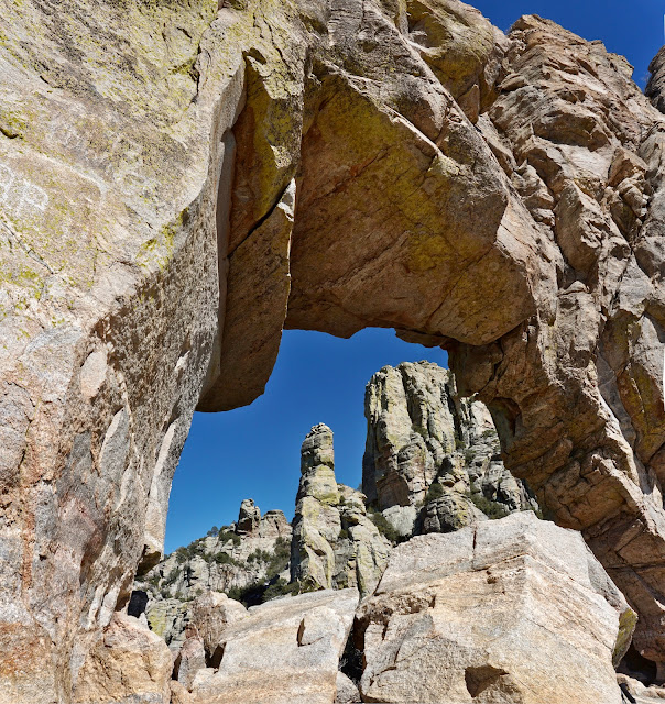
We threaded our way down to the Esperero Canyon Trail (5.3 miles) and turned left to circle under Window Peak at the base of its summit towers. This trail is mythical, even magical. Look down on the Window Rock structure that holds the arch. I won't belabor the description of the trail home because I have done so elsewhere and surely anyone doing this hike is intimately familiar with the footpath.
We threaded our way down to the Esperero Canyon Trail (5.3 miles) and turned left to circle under Window Peak at the base of its summit towers. This trail is mythical, even magical. Look down on the Window Rock structure that holds the arch. I won't belabor the description of the trail home because I have done so elsewhere and surely anyone doing this hike is intimately familiar with the footpath.

Of all the formations we've seen today nothing compares with Window Peak and its surroundings. We were embraced by columns and pillars of stone.

We stepped off the trail to imbibe in the glorious energy at Window Rock. (THW, photo)
The Esperero Canyon Trail drops well into
Ventana Canyon before its terminus at 6,200 feet at a principal trail junction. The Finger Rock Trail initiates here and goes west toward Mount Kimball. Turn left on the Ventana Canyon Trail. On our hike all the side streams were gushing. Waterfalls plummeted onto pure white boulders in the depths of the gorge. Cougar prints were imprinted in damp soil. It was an idyllic late afternoon.
The trail is rough and demanding so the downhill is not a gimme. The track is steep in places and rife with boulders. With evening pressing we decided not to visit the Maiden Pools at 4,200 feet. But do look up because you can see a lengthy portion of the Divide from the trail. Shortly beyond the pools is Ventana Vista.
This premiere viewpoint is followed by an abrupt dive down a series of switchbacks made of
natural stone steps.
On the canyon floor the path is bounded
by tower-forming metamorphic granitic gneiss. Saguaros provide a soothing and vertical
linearity in the chaotic landscape. We completed this deeply satisfying and epic journey as rolling darkness enveloped us and closed the day.