Essence: The Tumacácori Highlands are comprised of three small mountain
ranges (Pajarito, Atascosa, and Tumacácori) on the United States and Mexico border northwest of Nogales and west of the Santa Cruz River. Tumacácori Peak is not the tallest mountain in its namesake range but it is arguably the most important for its historical significance and everlasting visual presence from the centuries-old communities of
Tubac and Tumacácori, home of Mission San José de Tumacácori. The summit is encircled by a crown of cliffs. For hikers, there are several approaches that exploit weaknesses in the escarpment. The route recounted below scrambles up a Class 3 wall on the southeast slope. The rock is solid with plenty of features and dependable holds. This is a short, enjoyable hike with abundant rewards and solitude. An optional traverse down the west ridge and over to Point 5,022' is described. The hike is within the Coronado National Forest.
Travel: From Tucson, drive south on I-19, America's only metric interstate, to Exit 29 for Tumacácori and Carmen. It is also the exit for the Tumacácori National Historic Park. Measure from the bottom of the ramp. Turn right, then swing right, and immediately cross a cattle guard. You will need 4WD with good clearance and sturdy tires for this rutted and rubbly track, FSR 4145. The road climbs and crosses a gas line service road at 0.9 mile. Continue straight. At 1.6 miles, the road splits. Bear right on FSR 4145A. (The left branch goes to the Rock Corral.) Open and close a wire-latched gate at 1.9 miles. Park in a generous wide spot on the road (fire ring) at about 2.3 miles. Your mileage may vary.
Distance and Elevation Gain: Tumacácori Peak out and back via southeast cliffs is 2.2 miles with 1,400 feet of vertical. The alternate west ridge descent route and spur to Point 5,022' adds 2.2 miles and 700 feet. Total Time: Tumacácori Peak, 3:30 to 4:30; roundtrip spur to Point 5,022' adds about two hours.
Difficulty: Off-trail; navigation challenging; Class 3 with mild exposure; carry all the water you will need and hike late fall through early spring. Wear long pants.
Map: Tubac, AZ 7.5' USGS Quad
Date Hiked: November 29, 2023
Quote: Aridity rules the air, weathering rules the rock. The shadows are as deep as time. This land was born at the center of old. Ellen Meloy
Awakening light stretches out morning shadows. The structure of the upper mountain is aesthetically pleasing while posing a navigation puzzle for the climber. (Thomas Holt Ward, photo)

Route: From parking, walk northwest across the open desert to a reasonable crossing of a wash (most likely dry). Ascend north to the band of cliffs southeast of the summit. Climb the escarpment in a break that is comfortable for you. Bear northwest to the crest. Return as you came, or thread down the west ridge to the saddle. Continue west to Point 5,022' or descend southeast to your vehicle. I recommend avoiding the gully route, shown. Rather, stay east of the wash on tuff rock runners, to be discussed.

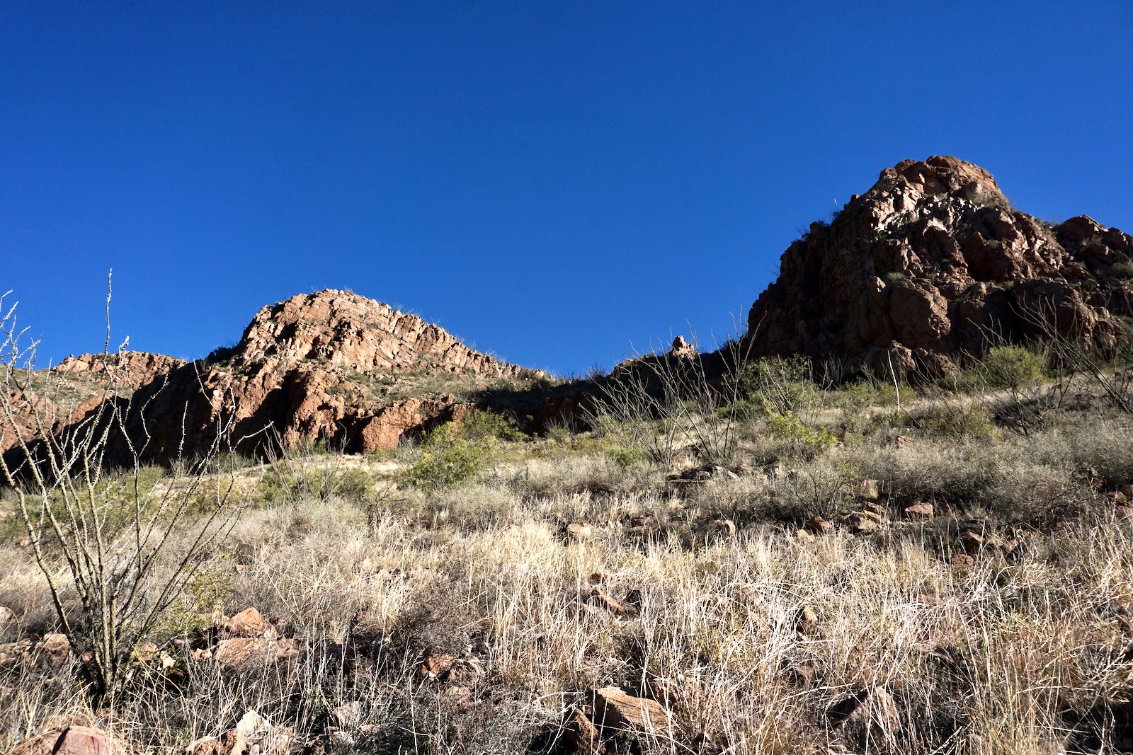
Tumacácori Peak shows its east face to the I-19 corridor. Seen from the gas line service road on the drive into the trailhead, the skirts of the mountain are composed of weathered volcanic tuff and the red cliffs are basaltic andesite.

We hiked in late November on a severe clear, cool day with nary a breath of wind. Pause to get your bearings and set your approach intention from parking, elevation 3,820 feet. How will you pierce the initial cliff band? The hike is trail-free and cairns are too infrequent to be of assistance. (THW, photo)

Trip reports we studied all initiated the climb from the pale stone toward the left of this image. Reportedly, this option is solid Class 3 with a chimney. Looking it over, we decided to aim for the obvious break in the wall west of the primary outcrop, image-right. (THW, photo)

We changed our minds once we got to the base of the cliffs because the low Class 3 scramble immediately in front of us was irresistible. (THW, photo)

To begin, hike northwest across a stony flat, weaving between a typical mix of desert scrub--whitethorn, pricklypear, mesquite, and sotol. Locate a workable crossing of a west tributary of the Santa Cruz River at about 0.3 mile.

Brush is less bothersome away from the drainage. Plow north up a slope enhanced by ocotillo, paloverde, and rainbow mammillaria. The pitch steepens at 4,100 feet. Boulders rest on slabs of welded tuff. At this point, we were simply aiming for the base of the cliffs to the left of the outcrop on the right. (THW, photo)
Reach the scarp at 4,500 feet. We lucked out because the break in the cliff immediately in front of us was so enticing we didn't even consider checking out other options. Our route was a fun, Class 3 scramble on excellent stable rock with plenty of hand and foot holds. Exposure was mild on the 50-foot pitch. (THW, photo)

Continue climbing and scrambling steeply north up a slope strewn with large rubble. Most of the rock is well seated and stable. Watch out for the shindaggers. We alighted on the east ridge at 0.75 mile, 4,700 feet. A single cairn placed previously marked this location. (THW, photo)

Bear northwest. We happened upon a series of rock walls all over the upper mountain that appeared to be erected by the Tohono O'odham or their predecessors, the Hohokam. They all had the same form, loosely stacked blocks. The curved wall shown below was at the precipitous edge of the escarpment. Present day O'odham living in close proximity to the Santa Cruz River are the Tohono O'odham (Papago), or desert people, and the Akimel O'odham (Pima), or river people. (THW, photo)

I love the structure of this mountain with its graduated tiers of stone. We really didn't know what to expect, or even if we could make the summit, so we were delighted not only to discover an obstacle-free passage but a welcoming mountain that exceeded our expectations because the rock was good and the scrambling was entertaining.

Intuitively follow the flow of the mountain and at 4,800 feet you will pass a peculiar and entrancing large stone wave. (THW, photo)

At 4,900 feet the ridge is a little gnarly straight on so we bypassed on the southwest and then returned to the centerline. The ridge pinches to a single string of jumbled boulders. (THW, photo)

They provide a sense of security as you clamber through them.

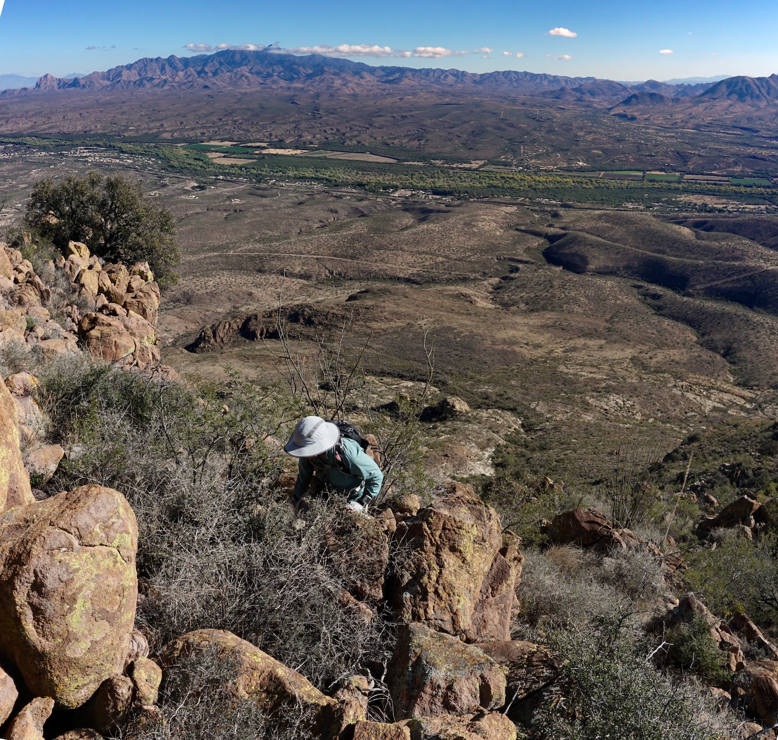
The pitch to the false summit is steep and rocky. This image looks down on the Santa Cruz River Valley and afar to the Santa Rita Mountains. (THW, photo)
As you approach the crest the grade tapers and the mountain rounds off.

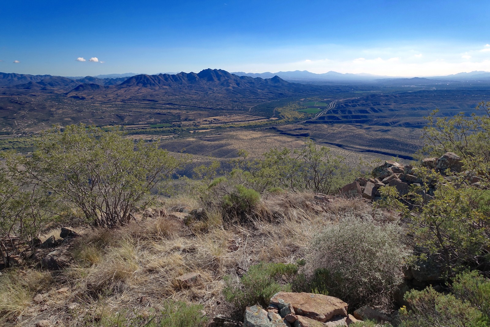
Arrive on the peak at just 1.1 miles. A large rock circle is intentionally positioned on the summit. Outside the wall are nooks and crannies, sitting rocks and vantage points. Tumacácori is the easternmost summit in the range with a prominence of 517 feet. The view to the south takes in the peaks shedding into Rock Corral Canyon, including the Tumac Benchmark and Peak 5,736', the highpoint in the range. (THW, photo)

Southeast, I-19 rolls through the great river valley. Rising above are the San Cayetano Mountains and in the blue distance, the mysterious mountains of Mexico. Off image is a grand sweep of Southern Arizona sky islands--Baboquivari, Tucson, Santa Catalina, Rincon, and Santa Rita mountains.
The unlabeled benchmark appears to be copper rather than the standard brass. The peak register is in an ammo can deeply buried in the summit cairn. The current register was placed in 2020. Older scraps of paper can be found in the box. If the register can be trusted, the peak is rarely climbed. We were the ninth entry in over three years.
The Green Valley Hiking Club was on the mountain in 2022. The Southern Arizona Hiking Club signed in a couple of weeks before us.

How you depart the mountain will depend on your intention. If you are thoroughly satisfied and want to take the most efficient route back to your vehicle, retrace your steps. If you'd like to see more of the mountain, descend the west ridge to the saddle and then bail to the southeast. We descended west hoping to traverse to Peak 5,687', our turnaround on a tour of the range in 2020. We didn't connect the dots this time but we did get over unnumbered Point 4,940' to Point 5,022', described below. Sardina Peak is image-right.

The west ridge is a cascade of cliffs and rock stacks. Bouldering moves are constant. It is enjoyable but not fast. Ease down a Class 2+ crack. This image looks back up at the crack.

We worked around the cliff bands pictured on the south but there might be a more elegant route down the center.

We found another stone wall on a platform at 5,000 feet. Caution! The ridge plummets abruptly at a 100-foot vertical escarpment. I felt it before we arrived--something awry in the visual field that signaled danger. (THW, photo)

The workaround is on the north side of the mountain. We dropped about 80 feet and then cut back to the ridge without difficulty. Wiggle your way down through much more forgiving ribbons of tuff. (THW, photo)

Drop into the 4,740-foot saddle at 1.5 miles, image-left. All routes back to the parking area leave from there. Our traverse to Point 5,022' was 1.8 miles roundtrip and took about two hours with over 700 feet of vertical gain. We decided to bypass the first tuff-layered prominence on the north. That proved to be a good call because it has a humongous cliff on its west side.

We took the first roller, Point 4,940', head on and contended happily enough with a scramble up through discombobulated boulder blobs.

We avoided most of them on our return by scampering over an appealing tuff bench, shown. This image looks back on the barrier wall of the knob just west of the saddle.

We topped a knob only to find it was a false summit so we worked our way over to the nondescript high point at 2.0 miles. Traversing to Point 5,022' looked somewhat troubled but we were determined so we dropped into another 4740-foot saddle. (THW, photo)

We were concerned about an orange wall half way up the prominence but it was an easy scoot-around on the north. From there the remainder of the climb was straightforward on the ridge crest.


We crested Point 5,022' at 2.4 miles. The traverse to Peak 5,687' looked to be more of a commitment than we wanted to undertake. The ridge was proving to be more time-consuming than the traverse to Peak 5,687' from the Tumac Benchmark and the range highpoint. Every footfall had to be monitored. Plus, it wasn't clear we could negotiate the final pitch to the summit. So we regretfully headed back.

For those who want to continue perhaps this image will be helpful. It was shot from Peak 5,687' in January, 2020. Point 5,022' is image-center.

We were back at the exit saddle at 3.3 miles. There was a magnificent cane cholla with three bird nests. Looking at trip reports after our hike, there are other treasures in this area that we overlooked including a cave and a mine. Some people visit the mountain exclusively to find wild chiltepine pepper plants. Found only in the Coronado National Forest, they are the only native pepper in the United States. In 1999, the Forest Service designated the Wild Chile Reserve in the
Tumacácori Mountains. The 2,500
acre special management area surrounding Rock Corral Canyon is home to
the largest population of wild chiles in Arizona.


Running south from the saddle a 300-foot swale (shown) sheds into the west fork of the Santa Cruz waterway. We were aware that the Southern Arizona Hiking Club essentially dropped 800 feet via the swale and gully to the flats. We gave that a shot. Gullies in the Sonoran are rarely pleasant and this one was typical with rolling material, entrapping thorny shrubs, and catclaw.

As the ravine deepened, gorgeous sculpted walls encroached and it was abundantly clear we needed to exit the trench. We climbed out and bypassed on the east where the terrain was friendlier. Eventually we got back in the wash and enjoyed some bedrock sections and a series of cascading tanks.

At 3,960 feet we crossed over to the west side of the wash and swooped easily across
pleasant sloping flats to the parking pullout, our vehicle visible all the while. (THW, photo)

If I repeat this hike I will stay out of the gully and explore the open slopes southeast of the saddle. As seen below, there are sheets of tuff and rock runners begging to be explored.
According to Will C. Barnes in Arizona Place Names, Tumacácori is derived from Papago "Chu-uma Kakul" meaning "white stone bending over," or Caliche Bluffs. (THW, photo)
