Essence: This post is the story of our initial exploration in the Cerro Colorado Mountains, a small range west of the Santa Rita Mountains and north of the Tumacacori Mountains. We were attracted to the wild formations and colorful, radical, volcanic cliffs on the west side of the range. The hike to Peak 5,034' was well within our capability but the summit block of Peak 5,132' eluded us. We found no trip reports for either peak. Neither did we see any evidence of previous hikers, although there is a migration pathway in the lower elevations. The hike is wholly within Arizona State Land Trust property. 2022 Addition: Please see the end of this post for a brief route description to Colorado Benchmark, highpoint of the Cerro Colorado Mountains.
Travel: The drive is a commitment for those coming from Tucson. From I-19 take Exit 48, Arivaca Road. Measure from the bottom of the southbound offramp and drive west on Arivaca Road. In one block turn right in Arivaca Junction and turn left in another block. Paved Arivaca Road points directly at the Cerro Colorado range. The road eventually skirts south of Cerro Colorado, 4,207'. At 14.6 miles, turn right on West Las Guigas-Cerro Colorado Road, a graded dirt road. At 15.1 miles, the road bends to the right and transitions to Rancho Seco Road. Follow crafted, red metal signs toward Rancho Seco. A view of the west side of the range opens. Enter Rancho Seco at an open gate, white fence, and cattle guard. While a No Trespassing sign is posted, the road is open to the public. Rules and regulations for recreation users are posted. Pass a tank and windmill to the right of the road at 16.6 miles. At a Large Rancho Seco sign, 17.1 miles, take the right fork. Cross a wash at 18.0 miles and soon pass a big tank left of the road. Open and close a gate and enter Arizona State Trust Land. Take the right fork off the main road at 18.4 miles. Park here if you are limited to 2WD. The unmaintained track degenerates and becomes rubbly. We parked in a large, open level area at about 19.0 miles, 0.1 mile before a catchment on the right. You could conceivably continue with dedicated 4WD. Post a State Land Trust Permit.Distance and Elevation Gain: 4.8 miles; 1,400 feet of climbing. Add up to a mile and 500 feet of vertical for optional Peak 5,132'.
Total Time: 3:30 to 5:30
Difficulty: 4WD track, primarily off-trail; navigation moderate; Class 2 with mild exposure on Peak 5,034'.
Map: Cerro Colorado, Arizona 7.5' USGS Quad
Date Hiked: January 27, 2021
Quote: The whole point is to live life and be--to use all the colors in the crayon box. RuPaul
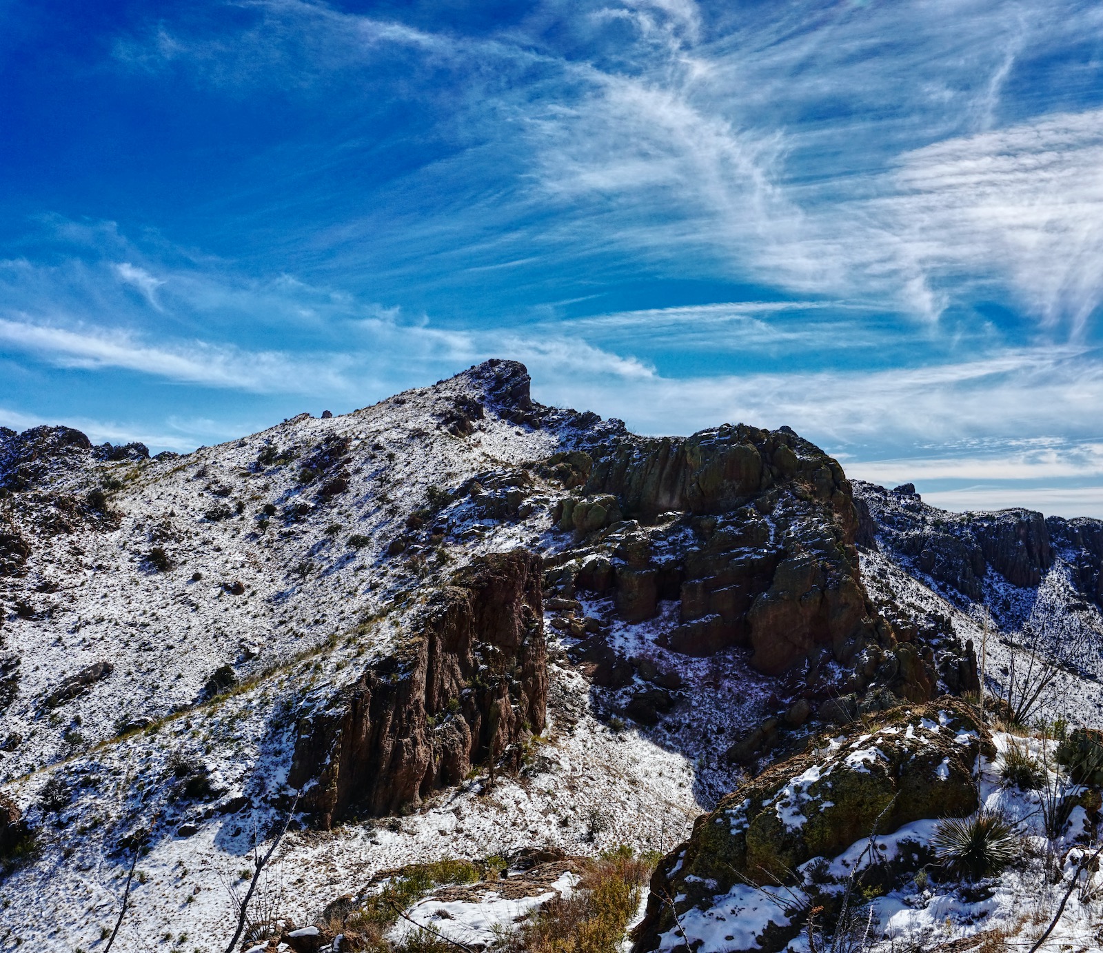
The cerulean sky and crystalline snow contrast with multi-colored stone formations in the Cerro Colorado Mountains and the Baboquivari earth pillar. Peak 5,132' is image-right. (Thomas Holt Ward, photo)

Geological Note
The Cerro Colorado Mountains lie on an orogenic belt consisting chiefly of volcanic rock. The highest peak, Colorado Benchmark, 5,319’, rises 1,579 feet off the valley floor. A north trending block fault divides the range in half. East of the fault, basalt flows have weathered into soft, flowing hills, pictured below. The basalt was stripped off the western face and the uplifted mass of tuffaceous beds eroded into precipitous cliffs and serrated ridges. A wide variety of rocks in colorful hues are exposed on this hike: gray-pink rhyolite, microcrystalline quartz, brown biotite, black basalt, and diversely colored, welded tuff conglomerate. For more information on the geology, consult, Russell Smith. “Geology of the Cerro Colorado Mountains, Pima County, Arizona.” Arizona Geological Society Digest, Volume 8, 1966, 131-145.

Route: From the parking area, continue up the 4WD track northeast to road's end. Hold a northeast bearing to the Peak 5,034'-Peak 5,132' saddle. The blue-line designates an alternate route to a higher point on the ridge. Ascend roughly south to Peak 5,034'. Return as you came. For those going on to Peak 5,132', hike northwest from the saddle to the summit block. Note: the Cerro Colorado topo has 20-foot contours.

When we started hiking it was 30 degrees with six inches of snow on north slopes. The majesty of Baboquivari Peak was sensational in bracing, ever-blue air. (THW, photo)

Both peaks are visible from the parking area, elevation 3,660 feet. The image below was shot in the afternoon when lengthy morning shadows were but a memory. Peak 5,132' is the tallest point on the right side of the tower cluster, image-left. Moving right, Peak 5,034' is the box stack sitting above a vertical escarpment, image-center. The Colorado Benchmark is off-image on the right. There are two prominent saddles in this image. The one you want is over on the left.


The road ends at 1.1 miles, 4,000 feet. Cross a small drainage, possibly on a game, cattle, or migrant pathway. I can't be sure because snow obscured our footing. We saw discarded items in this area. At 1.3 miles, stand on the east ridge of Point 4,243'. We made a crazy mistake here. We hadn't yet sorted out the landscape and simply launched toward the first obvious saddle we saw. It happened to be the saddle between Point 5,034' and the Colorado Benchmark, image-right. It wasn't until we got up there and were trapped that we recognized our error. The initial exploration of any mountain range in Arizona is imbued with anticipatory joy. Our primary purpose was to be present with the landscape so it was a fortuitous mistake.
For the proper saddle, hold the contour until you are in the draw between Point 5,034' and the Colorado Benchmark massif. Then do a rising traverse northeast until you contact the swale below the ascent saddle, image-center.

The bedrock sheds easily in these mountains and large volcanic boulders have rolled down the swale. The terrain steepens as you climb through grass and loose rock. It was considerably easier than our ascent to the previous saddle.

This image looks down on two stalwart towers standing in the draw in the afternoon. Reach the saddle at 2.0 miles, 4,670 feet. (THW, photo)

Peak 5,034'
The image below was taken from the south slope of Peak 5,132' and gives an overview of the climb to Peak 5,034'. Climb south over a small ridge (image-center) and drop into a higher saddle,4,730 feet. It may be possible to achieve this location directly from the swale (blue-line route) but I have not hiked it. We avoided the gendarme-crested northwest ridge by swinging across a bowl and contacting the northeast ridge of Peak 5,034' at 4,820 feet. This intuitive route worked beautifully. (THW, photo)
Turn up the northeast ridge and climb south to the summit. Akin to the other colorful elements on this hike, a purple pricklypear put on a dazzling display. (THW, photo)

Snow obscured the plants and rocks on the mellow northeast ridge.

Don't get your speed up as you crest the pin-point, exposed rocky summit at 2.4 miles. Westward, the earth crashes down the near-vertical escarpment. The Buenos Aires National Wildlife Refuge playa offers no hinderance in the visual field between us and Baboquivari. We could even make out the observatories on Kitt Peak. We were so fortunate to be visiting this exquisite little range on a day when visibility exceeded 100 miles. (THW, photo)

Due east of the Santa Cruz River valley are the stately Santa Rita Mountains.

The ridge continues rolling south to the Colorado Benchmark. Our mistaken saddle is an abrupt 500 feet below.

Across the tablelands in the north are the more expansive Sierrita Mountains. The communication towers were visible on Keystone Peak, 6,188', the highpoint of the range. (THW, photo)

Peak 5,132'
Most hikers will choose to retrace their steps from the ascent saddle. We knew that Peak 5,132' had been successfully climbed but that was the extent of our knowledge. From the saddle, we mounted northwest in the open swath west of the knob, image-right.

We moved into a spheroidal and chaotic welded tuft community. It was easy enough to move around but some of the rock was friable. Stones separated from bedrock with just a little tug. Very large conglomerates were being freed from their mother stones. We regarded the south face as technical, seen below, but now wonder whether we should have taken a closer look. We headed straight for the north side hoping for a ramp. We flanked the summit block on the east on a steep side hill and then climbed onto what turned out to be a blade north of the block, elevation 5,070 feet, just 0.3 mile from the saddle.

Three mounds north of the blade looked appealing. My partner later climbed a Class 3 crack actively exfoliating rock. He reported the knobs were a lot less friendly than they appear. They are ultra thin, cliff-sided crests with serious exposure.

From the blade, free-standing Peak 5,132' looked magnificent and truly monolithic...but not promising for the hiker. We crept along the west side at the base of the wall, image-right, but didn't find a viable route.

We backed out of there and found a sweet passage back to the east between the block and blade. (THW, photo)

We walked along the contact with the east wall and discovered a promising Class 4 route. The rock was wet and slick, and snow clung to the holds so we vowed to give it a try on another day. While it would be glorious to stand on top of the buttress, I've learned over time to respect rather than resent mountains that don't yield to humans easily.
(THW, photo)

Walking back from the saddle was magical. Baboquivari was ever present. There was open desert in all directions, raw, desirable, no sign of human habitation. We saw many deer, a black vulture with white wingtips, a red-tailed hawk, and a mammillaria camouflaged to match the rock it has grown up with. (THW, photo)

Colorado Benchmark, 5,319’
Essence: We wanted to explore further in the Cerro Colorado Mountains so we returned to climb the highpoint of the range. The hike is off-trail and rubbly; navigation is nuanced. Santa Rita prickly pear, fishhook barrel cactus, and grasslands flora are spectacular. A brief description follows.
Travel: From I-19, take Exit 48, Arivaca Road. Measure distance from the bottom of the southbound offramp and drive west on Arivaca Road. In one block turn right in Arivaca Junction and turn left in another block. Turn north 10.8 miles from the interstate, between Mile Marker 13 and 12. Open and close the gate. 2WD vehicles should park just inside the gate. 4WD with high clearance may continue to Horseshoe Tank. Once inside the gate, hang a sharp right, and then take the right fork.
Distance and Elevation Gain: From Arivaca Road, 9.6 miles; 2,300 feet
Total Time: 6:00 to 8:00 for the full hike
Difficulty: Jeep track, off-trail; navigation challenging; Class 2+ with no exposure; dress defensively, hike on a cool day, and carry all the water you will need.
Maps: Saucito Mountain, Cerro Colorado; AZ 7.5' USGS Quads
Date Hiked: February 3, 2022
Route: Drive or hike northwest up a jeep track to Horseshoe Tank. Leave the road at a pass west of the tank and hike off-trail north to the southeast ridge of the mountain. Walk the ridgeline to a saddle, then flank it on the east. Climb a swale to the south slope of the peak. Note: Both quads have 20-foot contour intervals.

Open and close the gate off Arivaca Road and either keep driving or start walking. From parking, elevation 3,450 feet, head east. The road splits; take the right fork. Below, the Surprise Well windmill, 1.6 miles, is pictured above two hikers. The Colorado summit is the craggy mass in the wedge between the rolling hills.

Some forcefully weathered, colorful yellow and blue-tinged volcanic tuff is right beside the road. (THW, photo)

The westbound road kinks south briefly at Horseshoe Tank, 2.7 miles. If you haven’t parked already, this is the time. The road tops out on a pass at 4,120 feet, 3.1 miles, and heads downhill. Leave the road at the pass and follow an abandoned track west to the center of the ridge. Start barging north; it is a steep, brushy, 600-foot scramble to the ridgecrest.

Turn northwest with the ridge. It is covered with talus and babyheads that roll underfoot. Grass obscures the ground; the going is slow. All the while, Baboquivari Peak is visible on the other side of Buenos Aires National Wildlife Refuge. Below, Colorado Benchmark is image-right.

Descend 180 feet into the saddle and hop a barbed wire fence. For the next half mile there is a faint trail. Judging from the discarded trash, this may be a migrant trail. It skirts the first ridge roller on the east, comes back to the ridge briefly, then flanks the ridgetop again. This is somewhat confusing terrain. The black line on the photo below shows the approximate route crossing a hillside and cutting into a draw in front of a standing rock with bright yellow-green lichen. (THW, photo)

At the head of the draw, shown, turn north to finish the climb.

Arrive on expansive Colorado Benchmark bedecked with solar panels and communication towers 4.8 miles from Arivaca Road. The benchmark was placed in 1923. Only the reference markers imprint the peak name. That mattered to us since we live in the southwest corner of the state of Colorado. (THW, photo)

Drop onto the flat platform just west of the peak to see the wild cliffs armoring the west face. Kitt Peak and the Santa Rita Mountains are off image but you can see Diablo and Sardina mountains on the north end of the Tumacacori Mountains.

Walk north for a stunning overview of the Cerro Colorado quadrant featured above.

On the return, do not be tempted by the social trail that leaves from the saddle north of the talus-covered ridge. We gave it a try and it tracked along the west slope nicely before disappearing and ditching us on a steep sidehill.