Essence: There is nothing difficult or even adventuresome about climbing Flattop Mountain. It's "just a walk" approachable by most hikers. And yet, it is a neglected summit. Arrive in solitude at the very Center of the World. The enormity of the mountaintop and south-facing escarpment creates a distinctive form easily recognized throughout the region. Amble at will over the acreage for rotating perspectives on much higher peaks. Flattop Mountain is a circular peninsula extending west from Bolam Pass, nearly encompassed by the Dolores River and Barlow Creek. Make it a two-peak day by moving your vehicle a short distance and taking a leisurely stroll southwest on the Colorado Trail to Section Point. The willow-choked summit negates visual rewards. Both hikes are within the San Juan National Forest.
Travel: FSR 578 is a 26 mile track
that requires 4WD low, high clearance, sturdy tires, and plenty of time.
It goes from Purgatory Resort on US 550 to CO 145.
From US 550: Measure distance from the Purgatory turnoff. Drive up the road into the ski area and turn right near the upper parking lots at the small brown building at the start of FSR 578, 0.4 mile. Turn right at 3.2 miles toward the Hermosa Creek Trail. At 3.6 miles go left staying on FSR 578. At 8.7 miles, the spur to a popular mountain bike trail branches left and Bolam Pass is straight ahead, nine miles away. Ford Hermosa Creek at a shallow, distributed, and flat crossing at 10.2 miles. Avoid in high water. The road degenerates and steepens after the Hotel Draw turnoff at 11.1 miles. There are sharp switchbacks and some shelf sections. Pass the mining ghost town Graysill with its chinked log cabin just shy of 17 miles. The Colorado Trail crosses the road at 17.3 miles beside a reflection lake. Head slightly right following FSR 578X. Top out on the pass, a wide spectacular platform, at about 18.1 miles. FSR 149, the road to the trailhead for Section Point is 0.9 mile west of the pass. For Flattop, park in a pullout on the south 1.5 miles west of the pass. It took us 1:15 from Purgatory in a Jeep Rubicon. Your mileage may vary.
From CO 145: The turnoff for FSR 578 is located between Rico and Lizard Head Pass. The sign on the highway reads Barlow Creek Road 578 (and yet it goes to Bolam Pass) and Cayton Campground. Cross the Dolores River and turn right onto 578. It is a good dirt road for the first 2.6 miles where FSR 496 branches right. Grind up the road. While the track is steep and rocky, it doesn't have the big clearance challenges found on the east side and it is shorter. For Flattop, park on the right at 5.9 miles. For the Section Point trailhead, turn right on FSR 149 at 6.5 miles. (Bolam Pass is at 7.4 miles.)
Distance and Elevation Gain: Flattop Mountain, 5.0 miles, 1,150 feet; Section Point, 6.0 miles 1,000 feet
Total Time: 2:30 - 4:00 for each hike.
Difficulty: Flattop, off-trail; navigation moderate; Class 2; no exposure. Section Point, Colorado Trail, off-trail; navigation easy; Class 2; no exposure
Map: Hermosa Peak, Colorado 7.5' USGS Quad
Date Hiked: September 29, 2023
Quote: Solvitur ambulando, "All things are solved by walking." Saint Augustine
As a twelver, Flattop Mountain is relatively short in stature by Colorado standards. But the sensation realized while roaming over the summit is gleeful, elevated spaciousness. (Thomas Holt Ward, photo)

Route: The black-line represents the most efficient route to Flattop Mountain. From parking on the Bolam Pass Road, bear northwest off-trail to Point 11,759'. Drop into a saddle and continue climbing northwesterly to the crest. For Section Point, the blue-line route, park at the end of FSR 149 and walk southwest on a two-track to intersect the Colorado Trail. Follow the trail to the north shoulder of Section Point. Pitch south to the summit.

Flattop Mountain, 12,098'
We made our first attempt to summit Flattop in mid-September, 2023. When we rolled over Bolam Pass, shown, weather was closing in. The meadows were completely saturated and the electricity began before 10:00. We turned around on Point 11,759'. Do not attempt this exposed hike if a thunderstorm threatens.

We returned on a bluebird day in late September. Again from Bolam Pass, to the north are the tempestuous San Miguel Mountains. From the left: El Diente Peak, Mount Wilson, Gladstone Peak, Wilson Peak, Cross Mountain, Lizard Head, Black Face, and San Bernardo Mountain.

Looking northeast, sharing a north to south running divide are: Sheep Mountain, "Lake Point," San Miguel Peak, V10, Grizzly Peak, and "North Point."

In contrast with the savagely ragged peaks, Flattop Mountain (image-left) looks downright humble. But our years-long curiosity had to be answered.

We parked well off Bolam Pass Road at elevation 11,320 feet.

Cross the road and traverse a large meadow framed by healthy spruce. Most of the flowers had gone to seed but bottle and little gentian, rayless senecio, and yarrow were hanging on. Wade through tall grasses bearing northwest. The summit remains out of view until Point 11,759'. Hold your bearing while stringing clearings together and eventually the way will become evident.

Ascend a slightly steeper pitch onto the southeast ridge of Flattop. Emerge from the trees into another glade.

Pass an intriguing mound of sandstone. 

Mount a short talus field.

Arrive on Point 11,759' at 1.1 miles. The promontory is a wondrous stone knob lookout that will orient you in space and place. While you can plot your route up Flattop, trees will soon obscure your path. Hold the northwest bearing! We walked over an exposed patch of Mancos Shale covered in fresh elk prints to alight on a beautiful little ridge. An informal use trail extends down the broken rock spine and enters the forest only to disappear.

Arrive at an opening with a view of Point 11,759', image-left. We headed over to the ridgetop. (THW, photo)

Mount a short talus field.

Arrive on Point 11,759' at 1.1 miles. The promontory is a wondrous stone knob lookout that will orient you in space and place. While you can plot your route up Flattop, trees will soon obscure your path. Hold the northwest bearing! We walked over an exposed patch of Mancos Shale covered in fresh elk prints to alight on a beautiful little ridge. An informal use trail extends down the broken rock spine and enters the forest only to disappear.

Give up almost 200 feet descending to the 11,580-foot saddle at 1.4 miles. Climb through deep woods clambering over fallen timber.

The grade moderates, and the spruce, shorter now, space themselves.

We walked up an exceptionally broad golden slope.

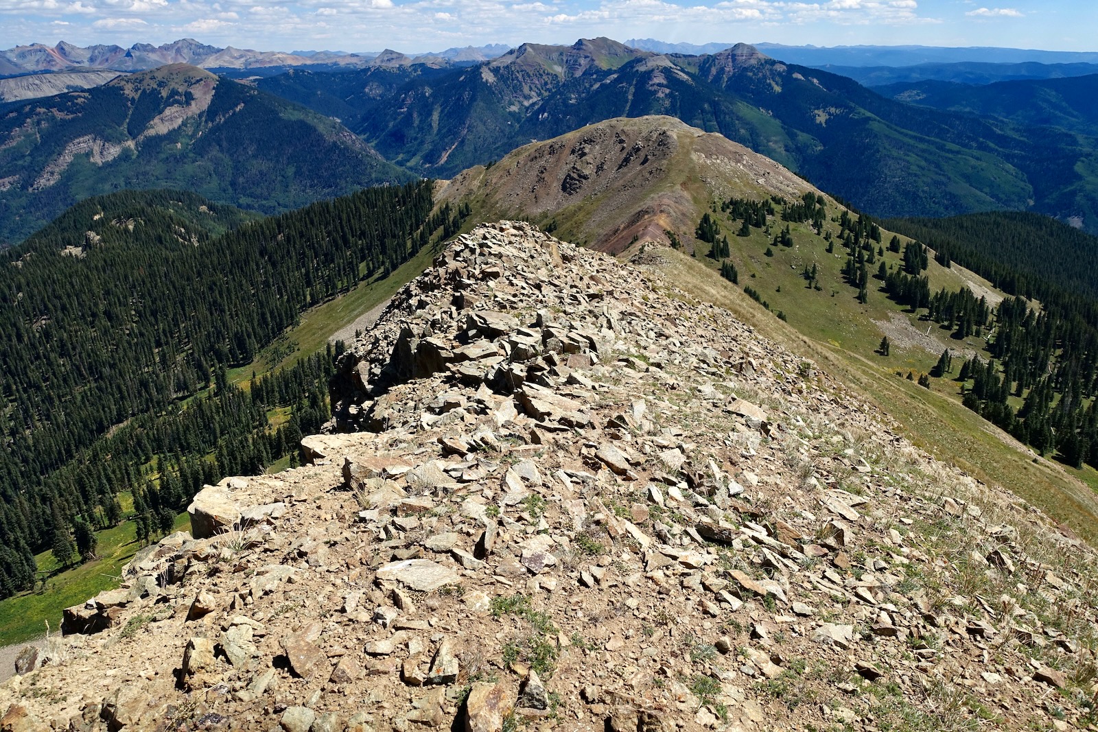
The summit is subtle but there is a highpoint at the apex of the voluminous spread at 2.3 miles. The crest is strangely uniform with nary a rock over two inches in diameter. Flattop's 798-foot prominence affords an excellent vantage point overlooking massive peaks that roll on and on, rippling ever outward to Lone Cone on the very western periphery of the San Juan Mountains. Below, Little Cone is image-left and Dolores, Middle, and Dunn peaks are on the right.

Twirling clockwise, next up are the fourteeners in the Wilson group. Walk northward and you'll see CO 145 going over Lizard Head Pass. (THW, photo)

The two hikers gazing toward the Mount Sneffles Wilderness provide scale on the seemingly unending mountaintop.

The summit provides a most excellent perspective on the San Miguel Peak group. The blade in front of V10 is Point 13,113'.

The Rico Mountains are nearby in the southwest. Dolores Mountain is on the east side of the Dolores River valley. On the divide west of the river running north to south are: Elliott Mountain, Sockrider Peak, Calico Peak, Eagle Peak and Anchor Mountain. (THW, photo)

As you stroll down the wide-open slope, get a bead on the ridge leading to Point 11,759'. For those adding Section Point, it is to the right of Hermosa Peak, image-right.

As you re-climb the small rocky ridge, about 60 feet off the top look to your right for an old two-track. It flanks Point 11,759' on the southwest. It's easy to spot.

The old trail is helpful for awhile but be sure to hold your southeast trajectory through multiple meadows and back to the Bolam Pass Road.

Section Point, 11,940'
We tacked Section Point onto our day because it was a ranked summit off the Bolam Pass Road. The drive is a commitment from Durango adding incentive for a second peak. Besides, the name was intriguing. (It remains a mystery. If you know the origin story, please leave a comment.) When seen from the pass on the Colorado Trail east of Blackhawk Mountain, Section Point (image-center-right) has considerable appeal.

The trailhead, elevation 11,380 feet, is 0.35 mile from the junction of Bolam Pass Road and FSR 149. Further travel is blocked by a berm.

Walk southwest on the abandoned road tracking along the base of the west face of Hermosa Peak. Stands of spruce rise skyward from meadowlands.

Intersect the Colorado Trail at 0.5 mile, remaining on the old road bed. The trail skims along the terminal embankments of Hermosa Peak's rock glaciers.

The path goes gradually downhill giving up 120 feet, the first of several undulations. At the runout zone of the second rock glacier at 1.0 mile, the trees open just enough to catch a quick glimpse of Flattop Mountain and its slide-away southern escarpment.

At 1.85 miles the old road continues straight and the Colorado Trail swings south on a single track. The image below gives a good feel for the crux on the southwest ridge of Hermosa Peak.

For trail hikers this is just a lovely walk on an impeccable pathway. The grade is mellow and the platform is generously dug into the slope below Point 11,866'. At 2.3 miles, Section Point comes into view. I'm enamored with the contrast of gold and deep forest green.

The treadway ascends to the shoulder of Section Point at 2.8 miles, 11,820 feet, image-left.


Leave the trail and pitch up the north ridge of Section Point.

The ridge graduates and constricts. The south face falls radically off as shown in the initial photo. The Colorado Trail flanks Point 11,752' (image-center) and makes for the pass between "Blackhawk East" and Blackhawk Mountain. Harts Peak is at the near end of what appears to be a flat blade.

We crested the seriously willow-choked and scraggly-treed summit at 3.0 miles. With a prominence of 360 feet this little mountain should have had a good viewpoint. We thrashed around searching but turned away disappointed. (There's a person in that bothersome willow patch.)

We retreated to the trail. If we had more time, we would have skirted the trail and climbed over Point 11,866', image-right, on our return.

If you'd rather not mess with Section Point, at the shoulder walk a few paces north of the trail to a small knoll for an exceptional view of Flattop and some of Colorado's most audacious peaks.