Essence: The intent of this hike was to climb Proposal, Emery, and Bonita peaks from a western approach. However, we were weathered out by mid-morning. Therefore, we settled on a circumnavigation around Proposal and Emery with a spur to Proposal. The three-peak cluster is bound by Cement Creek on the west, the South Fork of the Animas River to the south, and Eureka Gulch on the east. Western slopes are steeper than those on east; the easiest approach to all three peaks is from Eureka Gulch. This hike scales precipitous slopes, has lengthy courses of side-hilling, and crosses streams of talus. Visit six high basins with spectacular wildflowers. Views of the San Juan Mountains are boundless. Note: The LiDAR elevation measurement for Proposal Peak is 13,339 feet with a prominence of 559 feet (Lists of John). This hike is contained within the San Juan National Forest.
Travel: From Silverton, in a vehicle with 4WD (low helpful) and moderate clearance, drive up
the main drag. Measure from the junction of Greene Street and San Juan
County Road 2. Stay on Greene Street and wind up the hill past Memorial Park. The road
transitions to CR 110 and dirt at 0.8 mile. Drive northwest up the
Cement Creek corridor. Pass Silverton Mountain Ski Area at 5.7 miles. The road
splits in Gladstone at 6.5 miles; turn right. (The left fork services Hurricane and Corkscrew passes.) The road bends around the water treatment plant for the Gold King Mine, site of the infamous 2015 blowout (and one of 48 historic mines in the Bonita Peak Mining District Superfund Site.) On a platform at 6.7 miles hang a left going uphill. Then in about 200 feet, make a hard right onto CR 51 and bear southeast. The road has a fairly clean surface but it is steep and narrow. Conifers give the shelf some sense of protection. The road makes a long switchback and then heads back south. At 8.2 miles, park on the side of the road at a junction where CR 51 makes a 90 degree turn to the left (and ends at the Lead Carbonate Mill).
Distance and Elevation Gain: 4.9 miles; 2,250 feet of climbing
Total Time: 4:00 to 5:30
Difficulty: Primarily off-trail; navigation challenging; Class 2+ with moderate exposure; ultra steep slopes
Maps: Ironton; Handies Peak, Colorado 7.5' USGS Quads
Date Hiked: June 28, 2022
Difficulty: Primarily off-trail; navigation challenging; Class 2+ with moderate exposure; ultra steep slopes
Maps: Ironton; Handies Peak, Colorado 7.5' USGS Quads
Date Hiked: June 28, 2022
Quote: For those who climb, the answer is both obvious and impossible to explain—the everyday concerns of livelihood, of social standing, overdue bills, and futureless romance all fall away before the vast and overwhelming absolute of the mountain. Paul Watkins
Cast in morning shadow, the sheer west face of conical Proposal Peak is indomitable and silent. (Thomas Holt Ward)

Route: We ran the circuit counterclockwise. From parking, ascend southeast to the west ridge of Proposal Peak. Point 12,601' will be on your north. Sidehill south to the next westward ridge. This is the most challenging segment of the hike. Climb the south ridge of Proposal and retrace steps. Descend east into Slagle Basin. Cross over the east ridge of Proposal into McCarty Basin. You may climb Emery Peak from this basin. Contour around the east ridge of Emery. Climb west to the Emery-Bonita saddle. You may climb Bonita Peak from here. Pitch steeply down into Minnehaha Basin. From the Lead Carbonate Mill, walk on CR 51 back to your vehicle.

The first objective is the west ridge of Proposal Peak. From parking, elevation 11,540 feet, walk east up the road, immediately crossing Minnehaha Creek. Point 12,601' will be on your left. Severe and imposing, the razor-thin ridge has sloughed off most of itself creating rock glaciers in two adjacent basins. I was relieved it wasn't on the agenda. Leave the road where it switches north in a quarter mile. (THW, photo)
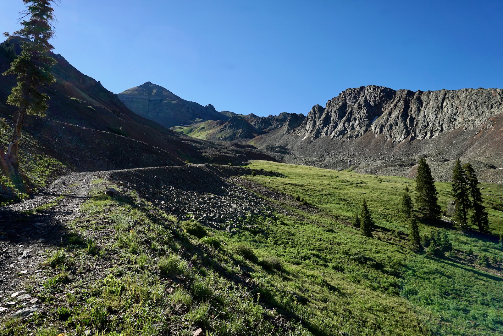
Favor the flowery slope to start. In 2022, summer monsoons kicked up in mid-June and the basin was lively with purple Silverton wallflower, lush snow buttercup, and alp lily. Work your way onto a chipped talus slope where, if lucky, you'll happen upon a historic burro track.

Back on the grass in the center of the basin at 12,100 feet, the west ridge is clearly visible, image-right. We climbed directly up the dry, stone waterway before working a series of benches. We essentially followed the path of three bucks that fled before us but it's intuitive and other than the acute angle of the slope, there's nothing tricky about this first segment.

We gained the west ridge at 12,580 feet, just 0.8 mile into the hike. From here, we could see all three of our desired peaks. Below, Bonita is center-left and Emery is the rounded prominence to the right of their shared saddle.

The mining industry in this region created a complicated road system. In this image, Corkscrew Gulch Trail built in 1882, punches up and over the ridgeline between Red Mountain No. 3 and No. 1. Mount Sneffels can be seen in the distance between them. (THW, photo)

It is a 0.3 mile sidehill passage between the two westward ridges. This stretch should be attempted only by nimble hikers with experience crossing highly pitched slopes off-trail. Self-arrest would be difficult.

Most experienced mountaineers have situations that test their composure. Mine is tumbling exposure. My companion, braver than I, placed himself downhill from me as we crossed the slope. On a previous occasion this segment didn't phase one friend but another bailed and descended to the Middle Fork of Cement Creek at the Black Hawk Mine. "The lower part is a nightmare with steep, loose, and falling rock." More pleasantly, at skyline in the image below are the peaks ringing the Ice Lake Basin, South Lookout, Lookout Peak, the 13ers above Columbine Lake, Three Needles, and mellow T10. You can pick out the top of the Silverton Mountain ski lift on the near ridge to the west.

Gain the ridge at 1.1 miles, about 13,000 feet. To climb Proposal hike east up the ridge on pleasant terrain and intersect the south ridge. If you are not climbing Proposal hold the contour southeast to the 13,020 foot saddle between Proposal and Point 13,229' and descend east into Slagle Basin.
Note: Whether you are approaching Proposal from Minnehaha or McCarty Basin, the south ridge climb to the summit is the safest option.
The south ridge has three obstacles, shown. We bypassed the first on the east. The second is moderately exposed with very loose rock and poor holds. The south end of the tiny summit spine is impassible. We skimmed it cautiously on the west. (THW, photo)

It's just a few steps across the three-foot-wide cap ridge to the minuscule summit at 1.4 miles after 1,800 feet of climbing. The airy zenith is so tiny there's barely room to sit. And yet, legend has it that Peak 13,330' was given its informal name by Gerry Roach to commemorate proposing marriage to Jennifer on the apex. Judging from the peak register, there's not a lot of traffic on this spire. Most notably, on the record was a splitboard winter ascent.

The pinnacle looks out over over innumerable ranges and basins. Captivating close by to the south are Peak 13,325' ("Velocity Peak"), Storm Peak, and Point 13,053' with the passive microwave repeater. (THW, photo)

To the north is an equally perplexing mass of mountains. Pictured below, Bonita is image-left followed by Hurricane and Hanson peaks. Uncompahgre is its incomparable self. Dominating the foreground, the north ridge of Proposal makes its jagged way to unranked Emery Peak. The traverse is troubled with Class 5 towers composed of friable rock.
(THW, photo)

Trip reports vary concerning the likelihood of success on Proposal's east ridge. One climber descended the east ridge before cutting high in McCarty Basin over to Emery. But daunting obstacles have turned others back. The image below depicts the east ridge connector with the north ridge. On the skyline are more mighty mountains of Colorado: Handies Peak, Jones Mountain, Niagara Peak, and Half Peak.

Prominent on the divide north of the Animas River are triangular Dome Mountain, Point 13,321', and Tower Mountain.

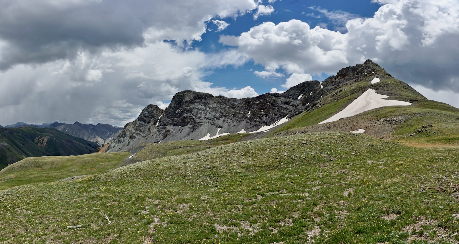
Retrace you steps on the south ridge until you are below the three outcrops. Then angle northeast down into beautiful Slagle Basin. We made for the 12,820-foot pass on the east ridge of Proposal that crosses into McCarty Basin, image-left.

This shot was taken from the pass looking into McCarty Basin. We contoured high at first, crossing swaths of tundra and rivers of rock. It would have been so simple to pitch up the green ramp to Emery Peak but the weather was threatening.

Our next objective was to curve around the east ridge of Emery and ascend to the Emery-Bonita saddle. We were racing rain so we moved fairly quickly through McCarty Basin--no time for reverie! We admired the tarn resting on a bench and thick patches of magenta paintbrush. We happened on a game trail at 12,400 feet that swung us into "Lake Emma Basin" before dispersing.

Eureka Gulch tops out at 12,080 feet in the glacial basin that once cradled Lake Emma. In the late 1880s, the Sunnyside Mine began working veins associated with the Eureka graben, a
volcanic collapse structure connecting the Silverton and Lake City
calderas. In the 1970s, a rich gold vein was excavated 70 feet under Lake Emma. On June 4, 1978, the bottom of the lake
collapsed into the active mining tunnel. Fortunately, the lake drained on a Sunday sparing 125 workers. Below, heading the basin on the north is Hurricane Peak, an exposed Class 3 challenge for hikers approaching from the southeast.

Cross another block field, this one exfoliated from Emery's north face. Deep rooted spring beauties tucked in the rocks contrast with explosive volcanics in shades of black.

Mount a false saddle and then climb pleasantly on tundra to the saddle at 3.7 miles, 12,780 feet. In 2011, I climbed Bonita from this saddle, descended over Point 13,228', swung west, and then worked back into Minnehaha Basin. Emery is more difficult--there is a vertical, chossy, Class 4+ notch composed of rotten rock beyond the false summit. (THW, photo)
We were disappointed to postpone Bonita but I've been a sitting duck dodging lightning strikes way too many times. We found broken miner's pottery beside the saddle tarn.

There is no best way down off the saddle and into Minnehaha Basin. The old pack trail shown on the maps passes through the low point but it quickly disappears having been eroded away. Unknowingly, we replicated my previous up-coming route. The ultra steep slopes were manageable by bearing southwest and searching out more gradual terrain. The flowers were outrageous both times I've been in this basin. Most notably, western valerian, king's crown, and delphinium were having an exceptional year in 2022. This image looks back up the slope to the saddle, center-left. (THW, photo)

As the slope graduates, head northwest to the Lead Carbonate Mill at 4.4 miles, 11,840 feet. Gold, silver, zinc, and lead were processed at the mill in the 1940s. (THW, photo)

It's a fast half mile from the mill down CR 51 to your vehicle. Thank you Dan Honig for pioneering this circuit route.
I snapped this photo before stuffing my camera away as rain and grapple overtook us. Emery Peak, Point 12,601', Proposal Peak, and the saturated basin reflect the weight of a water-laden sky.
