Friday, December 2, 2011

Grand Canyon Escalante Route: Tanner to Grandview

Geologic time!  How the striking of the great clock whose hours are millions of years, reverberates out of the abyss of the past!  The youth of the earth is in the soil and in the trees that spring from it: its age is in the rocks.   
John Burroughs, 1911

We lay upon thin pads borne by stone, faces to the thickly crowded starfield, measuring thirteen hours of true dark by breath and heartbeat and the rotation of the siderial clock. Cold clarity, absence of moon, the night sky with its archway of light was the best either of us had seen in decades.  Jupiter, King of the Planets, crossed the outer sky, a commanding yet comforting reliable orbiter of time.  Unbelievably, his orange brilliance was trumped on two nights (only momentarily) by exploding fireballs that separated into multiple meteors before appearing to plow into the South Rim very near Desert Watchtower.

I have a policy: no backpacking between November and February.  The firm grip of absolute night yields reluctantly to those precious hours when one may walk.  Still, here we were on the Escalante Route in the Grand Canyon between Tanner and Grandview.  We were fortunate to hold a permit at all but our allotment of a mere five light-deprived days left little time to explore.  My dream of Rim conquest via 75 Mile Creek and Papago will be realized in another season.  Delight was plentiful enough. As my companion observed, our trip was, "...full of capricious accident, and risk and reward, and all the effort and insecurity that makes life worthwhile."

November 21, 2011, Lipan Point. The moment of beckoning; two wanderers hear the river's call from the chasm.

It is a roughly 10 mile, 4,600 foot descent on the Tanner Trail to the river.  Here, we have passed through the Redwall and now must wait until our final day to do so again returning through brilliant reds below Horseshoe Mesa.  The tenacity of this limestone that renders passageway infrequent, the audacity of the rock!  It is my favorite canyon formation.

Hilltop Ruin at Unkar, is an ancient, stoic observer of the river and the boats she carries.  Great allures of this trek are panoramic vistas and the Grand Canyon Supergroup.  Comprised of nine layers, lavishly double red Dox Sandstone predominates in the Tanner region.  

The Grand Canyon traveler must be willing to walk on ever-so-thin edges and ledges. Find the skinny trackway on the far hillside made of Canyon Spice, the color of paprika and cayenne.  Careful!  The exposure is hot.

The gorgeous, sculptural walls of 75 Mile Creek Narrows.

Minuscule platforms in a slippery Shinumo Quartzite bowl provide sufficient purchase to descend into 75.  Another Supergroup formation, Shinumo is as beautiful as it is uncommon.

75's constricted corridor compels one to the river (so slowly).

Rock Beings enthrall.

The Colorado River, canyon-cutter, from the top of the Papago Wall just before a fun scramble (note, some find it alarming) down a rubble-filled gully and onto the treadway seen below.  Hance Rapids, the terminus of the New Hance Trail, is in the distance.  The Escalante Route wends for miles along the river. Ah the luxury of plentiful water while hiking in the Grand Canyon, so rare, so cherished. 

Even on Thanksgiving Day, in the Canyon rocks are still rocks and the roar of the river drowns words of wonder while a dyke of Cardenas Lava pierces Hakatai Shale above Hance Rapids at the mouth of Red Canyon. The hulking spire is simply the lesser end of a ridge spoking out from Escalante Butte.

The Supergroup meets up with 1.7 billion year old Vishnu Schist injected with Zoroaster Granite down in the basement of the world at Mineral Canyon and Granite Gorge.

From the Tonto at Mineral's edge, ever visible Vishnu Temple, guardian of our days, with its Coconino summit holds down familiar Canyon formations and a dwindling wedge of Supergroup sandwiched between Tapeats and Schist.  We wolfed down a most delicious Thanksgiving dinner at Hance Creek: chicken, potatoes, stuffing, gravy, peas, cranberries. Just-add-water and heat!

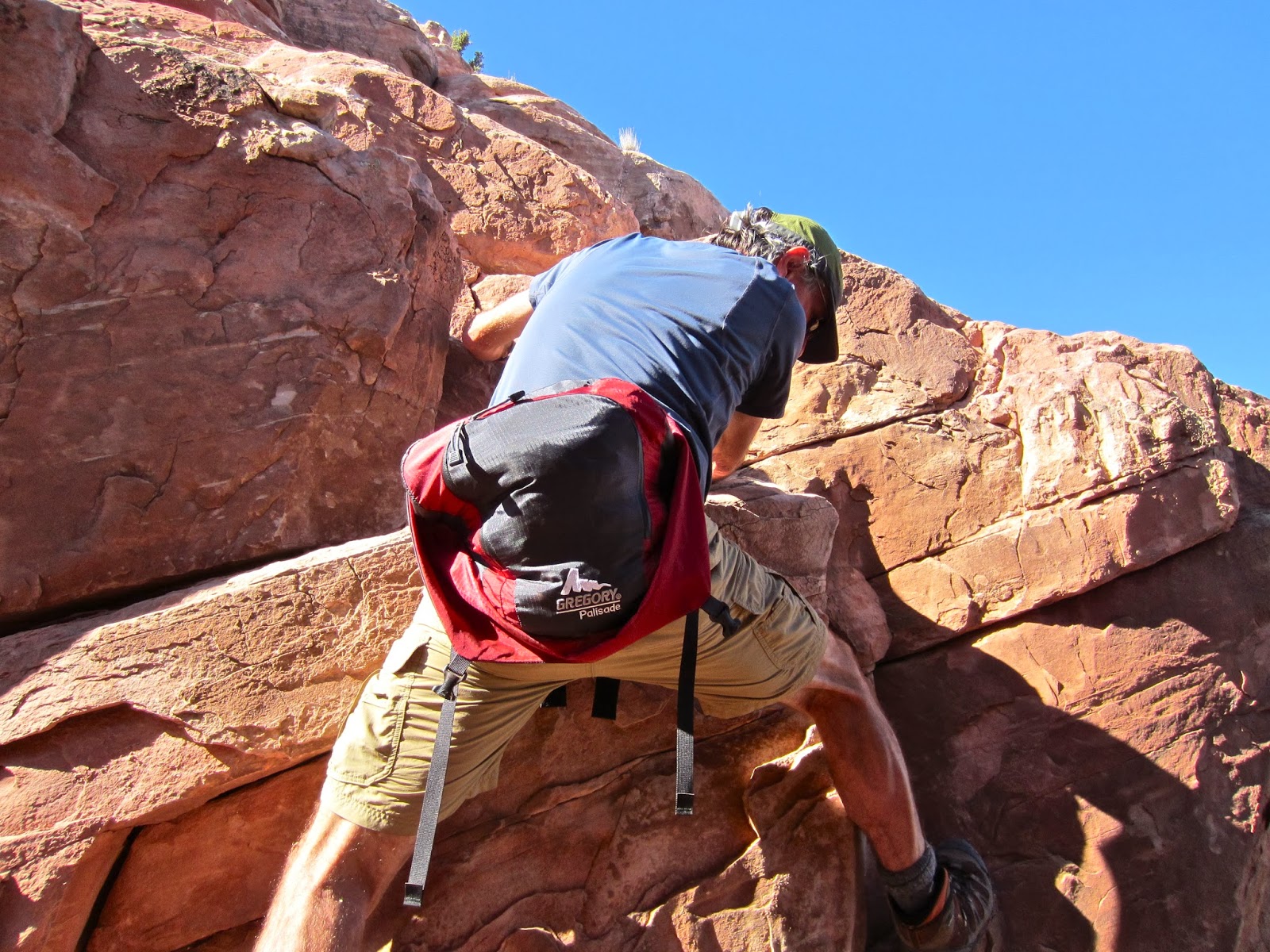
Circuit and summit the iron red Supai butte on Horseshoe Mesa.  Too much to hope for but not too much to ask, and joyfully receive. We finagled our way up through blocks on the north side until we reached the impenetrable 50 foot cap rock shown here. Cautiously we crept, circling around the never-ending butte on a rather frightening ledge to the rift at its east end. 

In this weakness was the only plausible route, a Class 4, lean-out climb.  The bravery of the scout must be recompensed.  Using excellent hand holds for the height impaired, I just managed to join him on the generous and welcoming summit.

From Grandview Point, our destination. In the cavernous space is a canyon of intimidating immensity but nearby in the center of the image I can't help but notice a Coconino ridge and butte anxious for a future visit from appreciative travelers.  Next time, perhaps.  And that is how we come to know this mind-numbing place, a human portion at a time. 

Friday, June 24, 2011

Cedar Mesa, Utah, Lessons in Self-Reliance

Here is elemental life, here is genuine freedom; but these exalted states are not to be won without strict conformity to the inexorable requirements of the land. Dr. T. Mitchell Prudden, early 1890's

As we hike so we live.  You could say that about most any endeavor, I suppose.  This little story chronicles a short trip over five days in separate canyons in Southeastern Utah. It is metaphorical throughout so make it your story if you like.

The drive to encounter the American Frontier lives in our cells. Is there yet a frontier? There's a quota system on the Grand Gulch Plateau, trails are trodden to talcum, every declivity and divide is delineated on the topo.  Even so, the explorer's heart may still be satisfied.

Solitude.  It's out there, enough to meet the need of the most ardent contemplative.  Solitude delivers by degree. Stay in camp with a good book. Share a trail. Or spend five days in absolute aloneness. No footprints. I did find one thin track on a bypass, disturbed cryptobiotic soil growing back now, like patina on a petroglyph panel.  Judging from four-legged tracks, coyotes, bears, cougars, bobcats, lizards, and rabbits noted my presence.  I startled a buck from his morning bed, irritated a red tail who swooped down from her tree skimming my head, listened to the distinctive flap of a raven's wing, and felt a black and yellow butterfly skim my cheek. To be so alone.  I found it startling, raw, virgin, deeply satisfying.  No one had been there for some time and no one was likely to happen along during my tenure.

Nine inch bear track.  In the morning our prints were equally fresh.  I snapped this in the afternoon with gratitude for these tracks signaled I was on the correct path to my truck.

I realize now that I unwittingly rely on people who have passed before to help me find my way.  In the wild I take heart in a footstep, a pile of rocks, advice from a guidebook, trails noted on a map, distinctive landscape features.  On this trip I chose the obscure.  After exploring this area for decades that's what I'm left with in order to enjoy the new while satisfying old curiosities.  Route finding was most difficult.  Self-reliance was paramount for only I could lead myself there and back. My footsteps are too ephemeral to be trusted.  Storms arise, wind erases.  So I steadfastly placed my own cairns, stacking a few little stones, a stick, some sort of marker device, at every branch in every swale, rivulet, dry wash, canyon.  Once I was certain where I was on my topo, I penciled in my route.  I trusted my knowledge of canyon architecture and wilderness experience to augment little waypoints. The return trip is so sweet.  Stepping on your own footprints, vestiges of self.  There's no comfort like it. "Oh there I am!" 

One of my Cedar Mesa/Grand Gulch Plateau 7.5 quads.  A topo serves as guide, documents where I've been, and some of what I've seen.

There are risks. I can't say there is a direct correlation between risk and treasure. That's probably a good thing. (I do believe there's a link between the number of visitors and site degeneration.) Quotas exist for popular canyons, those with the highest density of archaeological gems.  To find a ruin by intuition and searching rather than a GPS coordinate from a guide book or a number on a Trails Illustrated map, well, that feels like true discovery. 

Cedar Mesa multiroom dwelling.

The first move is walking out my door after canvasing friends and realizing I'm going solo or I'm not going.  That's an easy concern to dismiss.  The scariest risk to vanquish is starting out, taking the first few steps on a walk riddled with unknowns. Twice, I parked on roads with no tire tracks, roads that were not on my trusty map. I left the truck without knowing where I was exactly.  I walked into a pinon-juniper forest with no landmarks, searching for any indentation in the land that would indicate a water course.  I hiked for miles following the dry path of gathering waters.  Rivulet of soil to narrow drainage of sand and stone to wide wash to deep canyon to, finally, a side canyon or feature that pegged me on the map. 

Once I was in the canyon proper the real fun began for most of the traveling was on broad stone floors free of vegetation, the desert wanderer's dreamscape.

Stormlight upon the shallow, upper end of a canyon rarely visited.

There are obstacles.  Sandstone is prone to creating dramatic pouroffs, or barrier falls, that must be bypassed.  I took each attempt as far as I could and was often able to find my way around a dropoff.  But sometimes I was thwarted and had to return via another drainage, come up from below on a subsequent day, or give up altogether. Somehow it feels okay to be stopped by the landscape.  To turn back for lack of will or bravery?  Unacceptable.

Impassible pouroff near the head of a canyon on the Grand Gulch Plateau.

I'm learning to largely ignore guide books. Even simple things like distances can be way off.  Do these authors even hike?  This canyon reportedly ended, "in a sloped 40' pouroff and plunge pool almost immediately." When I checked it out I found the entrance slab to be a simple friction climb up an 80 foot watercourse.

Beyond several tricky obstacles, in the upper reaches of this canyon I found a great treasure, an impeccably crafted dwelling with a T-shaped doorway.  Its most unusual feature is the diamond design made of small stones pressed into the mud to the right of the door.  Finger indentations have endured for over 1,000 years.

There is no map to a hidden treasure, a search must take place, and this pursuit demands experience, dedication, and courage.

OK, so I took a few chances. I admit to periodic recklessness when I really want to get somewhere. The only reasonable way around this dryfall was down an eight foot wall.  It was easy enough to slither down backwards. And up? I wouldn't have dropped were it not for a three inch slope mid-way, my escape plan. Upon my return, I stacked up some rocks, then placed my backpack on the ledge above with the straps dangling in case I had to spend the night. Made it! Happiness. For it was a 15 mile day, 90 degrees, and my gallon of water was almost gone.

It was rather warm and flying teeth no-see-ums had their way with me.  The flowers were not plentiful but some prickly pear hybridized into astonishing colors.

A honey bee feeds from a pink penstemon at the base of a pinon.

May your explorations, inside and outside, be as rewarding.

Stewardship note: I always erase sign of my passage, all way markers and cairns especially. It is both irritating and confusing to find old cairns going every which way. We all want and need to find our own path when confronted with obstacles. Further, the absence of human placed features contributes to our sense of frontier.

This is what wilderness is to me: being alone and knowing no one is within miles, and that although others may have passed here there is minimal, or no, trace of their passage. That the materialistic agenda of everyday life does not pertain here. That here I set my own priorities based upon the immediate necessitites of survival. That my time is totally mine to use, to expend and extend as I see fit. That I am totally responsible for my own well-being. Wind in the Rock: The Canyonlands of Southeastern Utah, Ann Zwinger, 1978.

Saturday, January 8, 2011

Big Bend National Park: Initial Impressions


Seeking mid-winter warmth, I made a pilgrimage to the Rio Grande. If the Colorado is the mother river of never-ending life, the Rio Grande is the father. Having seen its source east of the Continental Divide near Creede, Colorado, I wanted to visit the river at the bottom of the country.  In Big Bend National Park the Rio defines the park boundary and the border between United States and Mexico for 118 miles where the sliding plane of water shifts from flowing southeast to northeast.

Sierra del Carmen, Mexico, across the Rio.
 
While all roads end at the river, Texas Farm Road 170 winds just above it between Lajitas and Presidio where the canyon-cutting waterway shows off beneath cliffs, bluffs, palisades, and mountains. Most of the River Road is within Big Bend Ranch State Park. Stop in at the Fort Leaton State Historic site (west entrance) or Barton Warnock Visitor Center (east entrance) to inquire about hiking permits and camping. For a short, delightful driving diversion, walk 0.7 mile down Closed Canyon.
 
I am a woman of the American West.  Now I fancy you can't call yourself a Westerner unless you've been to Texas.  It is the land of All The Pretty Horses, Lonesome Dove, and "True Grit".  Eight hundred and fifty miles from home, 200 miles into the state, I was still in Far West Texas, the mere western reaches of a measureless landscape. Texas gives new meaning to "vast". On lonely roads in the middle of this enormity, I'd raise one casual finger off the wheel when passing locals.  There are many opportunities. "The sun has risen, the sun has set, and here I am in Texas yet."

East into Texas and south into Mexico from the Southeast Rim of the Chisos Mountains.


I hiked extensively for seven days and saw only a minuscule portion of the 801,000 acre park. I'd start early in the morning under solstice light, imploring the sun to power up over the trees.  "Come on.  You can do this!"  Wearing four layers on top, the suffering continued in mittened, finger-nipping chill while the sun insisted on raking low across the sky as meager, dappled, half-tone shafts of light filtered through drooping juniper, Texas madrone, Arizona cypress, Chisos oak, bigtooth maple, and even aspen. While I heard rumors of stalking cougars and bears, I only saw plentiful Carmen Mountain white-tailed deer and a few javelina.

East view from Emory Peak, 7,825', high point in the park; yet another landscape that could gobble up an explorer's lifetime.

The Chisos is a mountain island in a sea of desert. I intended to climb Casa Grande but it must wait for a warmer day.

On Christmas Eve Day I climbed Emory Peak, sharing the lower trail with three Europeans, four Japanese, two from India, three Africans, two Spaniards, two from Poland, and hospitable Texans. Our national parks are international treasures.  Our campgrounds, places of refuge where kids ride bikes, couples drift at night greeting fellow travelers, one is invited for conversation over steaming cups of coffee in the chill light of dawn, and single men are hopeful.  "Please come over for chocolate and tequila.  I've got 12 liters for 14 days!"

Camping in December, I don't care where you are in this country, is all about cold management. Sun falls, the day diminishes and all too soon, vanishes. Darkness drifts down and crowds in.  I leap into the back of my truck at 6:30 and plow down to the bottom of my 30 below bag and settle in for 13 hours of winter night.  At 5,300 feet, space is shot with drifting stars and I measure time by the siderial clock.  By morning my feet are numb.

Enough!  I moved camp down to Rio Grande Village, elevation 1,850 feet, at the eastern edge of the park.  It was slightly warmer and a considerable coyote pack yelped through its yippee yap yowling repertoire all night long. Now I was on the river and in the Chihauhaun desert which extends deep into Mexico.  This is what I came to experience.

Chisos Mountains, Emory Peak, from the campground at Rio Grande Village, evening.

I walked an entire day without seeing a footprint into large-caliber roughlands.  Solitary cactus country, pierced by rare silence, I exhilarated in pure Chihuahuan remoteness. Most days I stayed on the treadway.  It was considered odd indeed to be hiking alone in a place where people find safety in numbers.  There is that side of Big Bend.  Park literature warns of drug runners and robbery.  I kept my valuables on my back or in an unsecured javelina-proof food locker at my camp site rather than in my truck at the trailhead. I felt safe enough.

People commonly canoe or ride horses across the Rio from Mexico into the park. Creosote bushes are in the foreground.

Not a dull-hued desert, even euphedra is carmine tipped.

Purple prickly pear are common.  Lechuguilla is the signature plant of the Chihuahua Desert.

Off-trail once again, I just had to climb the mountain on the right, working my way up through a spheroidal weathered granitescape and cactus obstacles. Oh the cat claw!

Driving home in a massive storm was harsh and exhausting but I got back to Durango in time for a seven degree snowshoe along the Animas River on New Years Eve.


Go to Big Bend.  The flowerscape will be truly amazing in the spring.