Essence: Wonders never cease on the Superstition Ridge traverse. Weave through weathered stone spears, spires, and spheroidals. Walk past sharp rhyolite columnar cliffs. Look north into the complexity of the Superstition Wilderness and onward to the Four Peaks. From the south rim, the earth drops 2,000 feet, inches from your perch. Along the way visit The Flatiron; Ironview Peak, 5,024'; Peak 4,869'; Superstition Benchmark, 5,057' (aka, Superstition Peak, Superstition Mountain); and Robbers Roost. Sections of the ridge trail were severely damaged in the Siphon Fire (September, 2024, 15,527 acres) and are difficult to decipher. Considerable navigation savvy is required. This is a long, demanding hike with scrambling and significant elevation gain. Hike when daylight hours are long, temperatures are cool, and there is no threat of inclement weather. I fell in love with the Superstitions on my first solo hike in 2001. While I have covered some miles in the range since then, my apologies to the many locals obsessed with the Superstitions for any ignorance displayed herein. The traverse is within the Superstition Wilderness managed by the Tonto National Forest.
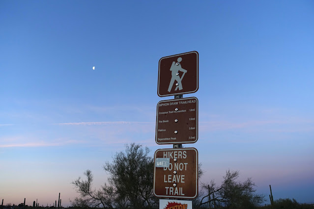
Travel: This traverse requires a shuttle. Drop a vehicle at Peralta Trailhead. From Apache Junction drive east on U.S. Route 60 for about eight miles to the traffic light at Peralta Road. Turn left and continue 7.3 miles to the trailhead. For Siphon Draw Trailhead, from the intersection of Lost Dutchman Boulevard and Apache Trail (AZ 88) drive north along the western front of the Superstition Mountains for 2.8 miles. Turn right into Lost Dutchman State Park. Go through the entrance station and follow signs to day use parking. NOTE: day use gates are closed and locked from 8 pm to 6 am. There is a restroom at Saguaro Day Use. Park at the Siphon Draw Trailhead. Water spigot.
Travel: This traverse requires a shuttle. Drop a vehicle at Peralta Trailhead. From Apache Junction drive east on U.S. Route 60 for about eight miles to the traffic light at Peralta Road. Turn left and continue 7.3 miles to the trailhead. For Siphon Draw Trailhead, from the intersection of Lost Dutchman Boulevard and Apache Trail (AZ 88) drive north along the western front of the Superstition Mountains for 2.8 miles. Turn right into Lost Dutchman State Park. Go through the entrance station and follow signs to day use parking. NOTE: day use gates are closed and locked from 8 pm to 6 am. There is a restroom at Saguaro Day Use. Park at the Siphon Draw Trailhead. Water spigot.
Distance and Elevation Gain: 15.6 miles; 5,400 feet
Total Time: 10:00 to 13:00
Difficulty: Trail, off-trail; navigation moderate to Carney Saddle and challenging from there to Fremont Saddle; Class 3 with no exposure; hike on a cool day; carry a minimum of six liters of fluids and a headlamp.
Total Time: 10:00 to 13:00
Difficulty: Trail, off-trail; navigation moderate to Carney Saddle and challenging from there to Fremont Saddle; Class 3 with no exposure; hike on a cool day; carry a minimum of six liters of fluids and a headlamp.
Lost Dutchman State Park: Show your Arizona State Parks pass or pay the fee.
Maps: Goldfield; Weavers Needle, AZ 7.5' USGS Quads
Latest Date Hiked: March 21, 2025
Poem:
Maps: Goldfield; Weavers Needle, AZ 7.5' USGS Quads
Latest Date Hiked: March 21, 2025
Poem:
He who binds to himself a joy
Does the winged life destroy
He who kisses the joy as it flies
Lives in eternity's sunrise.
Does the winged life destroy
He who kisses the joy as it flies
Lives in eternity's sunrise.
William Blake
Startled by the swoosh of ravens' wings, we paused briefly to watch them frolicking overhead. Stone beings are so enchanting all along the ridge it took a force of will to deny them our prolonged rapturous attention. There is little time to tarry on the lengthy traverse. (Thomas Holt Ward, photo)
Route: The hike begins at the Siphon Draw Trailhead in Lost Dutchman State Park and bears southeast to the Peralta Trailhead. Most features along the ridge are short, optional side trips. Reduce time and miles by descending south from Carney Saddle on the Carney Springs Trail. The contour interval for the Goldfield quad is 20 feet. Weavers Needle uses a more standard 40-foot contour interval.
Route: The hike begins at the Siphon Draw Trailhead in Lost Dutchman State Park and bears southeast to the Peralta Trailhead. Most features along the ridge are short, optional side trips. Reduce time and miles by descending south from Carney Saddle on the Carney Springs Trail. The contour interval for the Goldfield quad is 20 feet. Weavers Needle uses a more standard 40-foot contour interval.

The iconic western front of the Superstition Mountains is seen in late afternoon from the campground at Lost Dutchman State Park. Formations in the Superstition Wilderness were deposited during a period of intense volcanism between 3 and 25 million years ago. Extrusive igneous rocks include welded tuff (volcanic ash cemented under extreme heat), breccia, granite, dacite, andesite, rhyolite, basalt, and some conglomerate. Common volcanic landforms found in the eruptive field are consolidated deposits of pyroclastic flows, calderas, domes, blister cones, lava flows, and ash deposits. (THW, photo)

Siphon Draw to The Flatiron
The wide, well-signed footpath bears south and skirts the campground on the east. Flora on the bajada and seen throughout the hike is typical of the Sonoran Desert: palo verde, saguaro, ocotillo, chainfruit cholla, jojoba, and creosote. During March, the ground is typically a riot of color, but in this year of the big dry, not even the brittlebush was blooming. Stone spires and spikes cut riveting silhouettes against predawn light. (THW, photo)

Zigzag through a gate at 0.7 mile and enter the Superstition Wilderness. It was designated in 1939 and expanded to 160,200 acres in 1984. The imposing front wall of the range has a bold personality. Fangs, fingers, needles, tusks, bristles, columns--the rocks stand straight up in this crenelated world. Broken rocks overcome the smooth trail but still it is silent and peaceful as the terrain constricts and we are enveloped in stone. (THW, photo)

Massive blocks fallen from the cliffs above rest on the floor of the amphitheater. Mysterious dark caves pocket the south wall. Walk across a boot-smoothed bedrock bench, a hint of what is to come. (THW, photo)

At 2.1 miles enter a mind-numbing pink stone bowl informally known as "Slickrock Basin." A slip of water trickled into a pocket garden with bunched grass.

This magical mystery tour is brought to you by Earth Productions. This is one of the finest highlights of the entire hike so savor every footfall. (THW, photo)

The official trail ends at the top of the bowl below a seasonal waterfall. A white arrow directs into a constriction and bypasses the waterfall on the right. A path takes you over a low ridge at 3,400 feet and then descends slightly into the upper trough, shown.

Scramble up the boulder choked drainage, staying in the bottom of the canyon all the way. This is one of the sweetest stone corridors anywhere.

Low morning sun raked The Flatiron.

Siphon Draw concludes with a Class 3 scramble. Don't let this wall intimidate you. The holds are superb and it is great fun. If it seems a little scary have a friend give you a spot as you climb.

Emerge from the draw at 2.8 miles, 4,600 feet. It is a revelatory and wondrous moment to be on par with The Flatiron, a visually powerful landform. Follow the trail southwest to the east end of The Flatiron and then free-range out to the far west end. The surface is a sheet of bedrock with a smattering of thick-speared agave, pricklypear, and cholla.

Arrive on the rim of The Flatiron at 3.1 miles after 2,600 feet of climbing. Almost half of the total vertical on the traverse is polished off already. Gazing into cavernous space, the trail enters the mouth of Siphon Draw, the campground is laid out in a grid, and the Goldfield Mountains are west of Apache Trail. (THW, photo)

The people who inhabit southern Arizona have a sense of ownership when they look north across remote roughlands to the Four Peaks. (THW, photo)

It is possible to see the three ranked summits on Superstition Ridge from The Flatiron. Ironview Peak is left of "The Castle," Point 4,861'. To its immediate right is Peak 4,869', and Superstition Benchmark is image-right. (THW, photo)

Ironview Peak, 5,024'
The highpoint of the west face of the Superstitions is a short commitment and great fun for scramblers. We took the trail back to the head of Siphon Draw and continued a short distance north to see a plaque commemorating a 2011 airplane crash. We began the climb on a social trail bearing northeast.

The trail braids repeatedly. Weave around and through weathered towers and boulders. The trail isn't obvious so find your own best way up through exquisite spheroidals. On my first visit in 2003, I was guided by painted dots but they have (thankfully) faded.

Separately, my partner and I have climbed Peak 5,024' several times. Each time we crawled through two holes in the jumbled boulders.

Below, I'm pulling myself out of the first hole. (THW, photo)
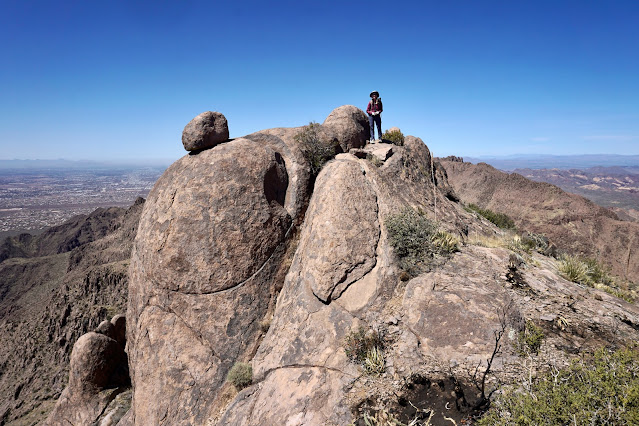
It is a pleasurable Class 3 scramble to the crest of Ironview Peak at 3.7 miles. We were now well above The Flatiron.
It is a pleasurable Class 3 scramble to the crest of Ironview Peak at 3.7 miles. We were now well above The Flatiron.

Whimsical boulders make this mountain really sweet. With a rise of 794 feet, views are sensational as well. The crest is almost 500 feet higher than Weavers Needle. For hikers doing the traverse, we actualized a shortcut my partner scoped from home. We saved considerable time and distance by descending eastward from the summit area. Visually locate the trail and aim for it (image-center).

Entire congregations of rock beings are imbued with personality. These hill climbers are leaning into the exertion.
(THW, photo)

The skyline was crowded with bands of standing rocks. (THW, photo)

In contrast to the Class 3 climb on the west side of the mountain, it was a ridiculously easy walk down to the trail. We intercepted it at 4.0 miles, 4,600 feet.
Peak 4,869'
The stretch of trail between the first two peaks is a riot of pleasure. Trail designers made every effort to stay on the contour. There are pinch points in the ridgeline where south-draining canyons plummet 2,000 feet. The footpath intentionally weaves through rock features. If I sat in one place for hours sorting out stones I'd still feel like I hadn't really actualized the scene. Below, the upcoming ranked summits are on either side of spike-topped Point 4,613'.
(THW, photo)

Two brilliant red violet hedgehog blossoms captured our attention. They were literally the only flowers we saw all day. (THW, photo)

At 4.8 miles we went through a gap in standing stones, lost about 100 feet, and then ripped back up the other side. The trail does an ingenious stunt by plowing between the walls of sizeable blocks, shown. (THW, photo)
This image looks back from a flat reprieve at south-facing layer cake cliffs. Ironview Peak is on the right. (THW, photo)

We left the trail to climb Point 4,613' but it had a technical highpoint. Total stone insanity. (THW, photo)

A little further along we were successful in climbing Point 4,642'. (THW, photo)
I recommend taking a few extra moments to play around on the fins. (THW, photo)

The trail flanks Peak 4,869' on the northeast because the ridge is spiky. Too late, we realized we could have stayed on top. The fire-damaged trail is but a thin thread on a very steep slope requiring some mindfulness.

The ridge trail intercepts the footpath to the peak. It is a mellow, no exposure climb northwest to the summit.

Arrive on the second peak of the day at 7.1 miles. With a rise of 519 feet, the vista is spectacular, especially looking north into the Superstition Wilderness.

This image is a good depiction of the northwest ridge scramble option.

Superstition Benchmark, 5,057'
The tallest peak on the ridgeline has multiple names. Lists of John calls it Superstition Peak, alternatively, Superstition Mountain. And yet, Superstition Benchmark is named on the topo. Back on the ridge trail, go up a small rise, Point 4,777', and then give up 400 feet.

Below, we are about to hit the low point, 7.5 miles, 4,350 feet. In this saddle the unsigned Hieroglyphic Trail comes up from the south. Of note, for those simply climbing Peak 4,869' and the Benchmark, this trail offers the most efficient access.

From there, we suffered some confusion about the route because the fire did extensive damage that has not been repaired. This image was shot from the saddle containing the Hieroglyphic Trail. Note the ridge trail climbing steeply left of the centerline.

The trail passes through a saddle northwest of Point 4,790', shown, and then flanks it on the west. Some cairns guided at first but they soon disappeared and left us wandering around probing.

When we were directly below the saddle between Point 4,790' and the Benchmark, we pitched east to the ridge, clawing up the hillside while contending with loose material. Eventually we found the trail and took it to the shared saddle.

Now what? We found a white painted arrow pointing to an improbable, narrow clef.

The Class 3 move up a big flake of rock was great fun.

Pass beneath abstract chest pieces and transition to the east side of the ridgecrest. (THW, photo)

At 8.5 miles, leave the official track and take a social trail northwest toward the Benchmark. The peak remained out of sight.

Free-standing needles cling to the side of the mountain.

My partner and I split up and explored two Class 3 routes as we approached the summit.

Top out on Superstition Benchmark at 8.7 miles after an accumulated gain of over 4,600 feet. The brass disk was placed in 1910. Two additional dates were imprinted in 1946 and 1965.

Superstition Benchmark has a mighty rise of 1,837 feet. This image looks southeast as the ridge steps down and the trail dives into Boulder Canyon.

Carney Saddle
The footpath is a smooth and fast downhill to start. At 9.6 miles the trail splits. The higher one climbs to an overlook and stops. This route takes the lower trail.

The trail is rough and rocky as it crashes down into Boulder Canyon. When it reaches the drainage it goes straight across and starts ascending. It was tiresome to grind uphill on tall boulder risers.

Arrive in Carney Saddle at 11.0 miles. Robbers Roost was on our wish list for many years so our plan was to visit the Roost then conclude the traverse by way of Fremont Saddle and the Peralta Trail. If you are not going to the Roost, it makes sense to exit on the Carney Springs Trail. Navigation from Carney Saddle to Fremont Saddle is challenging. A social trail exists but it is difficult to follow and faint in places. We have concluded the traverse on the Carney Springs Trail a few times. The trail is well established and direct but it is ultra steep as it stairsteps down the headwall.

Robbers Roost
From Carney Saddle the route bears east to the Roost and then north to Fremont Saddle. To begin, follow the thin track as it skirts the initial block, shown, on the north.

Again, this is not an engineered trail. In fact, it is more of a route than a trail. It would be all too easy to get lost wondering around in the wilderness at the end of a long day so hikers are advised to follow a trustworthy GPS track.

Go through a wide gap.

If you intend to tack Robbers Roost on the traverse, take someone with you who has been there before and can get you there on the first try. We couldn't find it on our traverse so we returned a few days later to search for it and it was a full hour commitment. If you dial the route, it adds 0.3 mile roundtrip and 120 feet of vertical. The stone draw holding the Roost, shown, is 0.1 mile before the trail swings from east to north, at about 11.8 miles. To begin, drop into the center of the draw.

We explored extensively on both sides of the draw. Every place we probed there were cairns leading every which way. We cliffed out at the top of pouroffs repeatedly. Once in the draw the non-technical, Class 2+ entrance to the bowl is on the east.

You can walk right under the boulder in the center of the pit.

We explored extensively on both sides of the draw. Every place we probed there were cairns leading every which way. We cliffed out at the top of pouroffs repeatedly. Once in the draw the non-technical, Class 2+ entrance to the bowl is on the east.
A gargantuan boulder on the floor of the hole and the massiveness of the smooth stone walls gives Robbers Roost a cool factor. There are stains on the walls where water enters the bowl from the north and pours out of it on the south. The Roost is an old Superstition hangout. People have been coming here for decades. Historic writing etched into one wall dates to 1935. Please do not add your mark. A plastic ammo box contains a notebook with pages of signatures. I was skeptical that the Roost would live up to the hype but now I'm a convert. (THW, 16 photo composite)
You can walk right under the boulder in the center of the pit.
Back on the trail to Fremont Saddle, follow it east 0.1 mile and then hook sharply north. The trail is clear to begin but soon you will need to follow cairns across sloping bedrock, shown. This is not an established trail and it would be very difficult, if not impossible, to follow it in the dark.

The route essentially parallels the Peralta Trail high above it. Just before it reaches Fremont Saddle it goes through a squeeze between large boulders and standing rocks. This image was shot from the saddle looking up at the pinch.

Arrive on Fremont Saddle at 13.1 miles. It is renowned, of course, for its vantage point overlooking Weavers Needle. We gazed upon the acclaimed landmark when it was pulsing amber radiance in evening light. (THW, photo)

Peralta Trailhead
You can make good time on the screaming 2.5 mile downhill southeast through Peralta Canyon. The popular trail maintains a comfortable grade with stone steps. Standing stones packed together on the west wall look very much like the communities of rocks we saw on the west end of the traverse. (THW, photo)
One mile below the saddle, look east to see Geronimo's Cave at the contact with ash-flow tuff.

Complete the traverse of Superstition Ridge at the Peralta Trailhead, elevation 2,400 feet. As the opening poem implies, joy is fleeting by nature. But there's a way in which joy accumulates over the long miles on this hike and lives on eternally through images seared into memory in the present moment.
