Travel From Durango via Engineer Pass: In a 4WD, high-clearance vehicle, from Durango drive 47 miles to Silverton. Turn northeast and proceed up Greene Street, the main drag, to the north end of town. Zero-out your trip meter as you make a soft right onto CR 2 which is paved for the first few miles. The dirt road is good at first but degenerates to a slow, rocky surface. In 11.8 miles, 0.5 mile before reaching the abandoned mining town of Animas Forks, bear right on the Alpine Loop and follow the signs for Engineer Pass. It is 4.8 rugged, edgy miles to the pass at 12,800'. Drive down the east side 9 miles to the ghost town of Capital City at 25.6 miles. Turn left on North Henson Rd and continue for 2.7 slow miles to the upper TH at 10,720'. Allow three hours from Durango.
Travel From Lake City: Turn west onto Second St. In two blocks, go left on Bluff St. In one block, bear a soft right onto Henson Creek Road, Hinsdale CR 20. There is a sign on the right designating the Alpine Loop. Zero-out your trip meter. Pass Nellie Creek Rd in 5.2 miles. Reach abandoned Capitol City in 9.2 miles and turn right on North Henson Rd. The track gets rough but can still be driven by most good-clearance vehicles. The Matterhorn Creek TH, 10,400', is at 11.2 miles. IF you have 4WD, HC, proceed 0.7 mile to the upper TH at 10,720'. Allow one hour from Lake City.
Distance and Elevation Gain: 8.8 miles, 4,848 feet of vertical from Trailhead 10,720'
Time: 6:00 to 7:30
Difficulty: Trail, off-trail; navigation critical for Wetterhorn, easy for Matterhorn; Class 3; considerable exposure on Wetterhorn, no exposure on Matterhorn
Maps: Uncompahgre Peak; Wetterhorn Peak, Colorado 7.5 Quads
Dates Hiked: September 3, 2011; July 15, 2012
Quote: The outer world is necessary to activate the inner world. They are not two worlds but a single world with two aspects: the outer and the inner. If we don't have certain outer experiences, we don't have certain inner experiences. Thomas Berry.
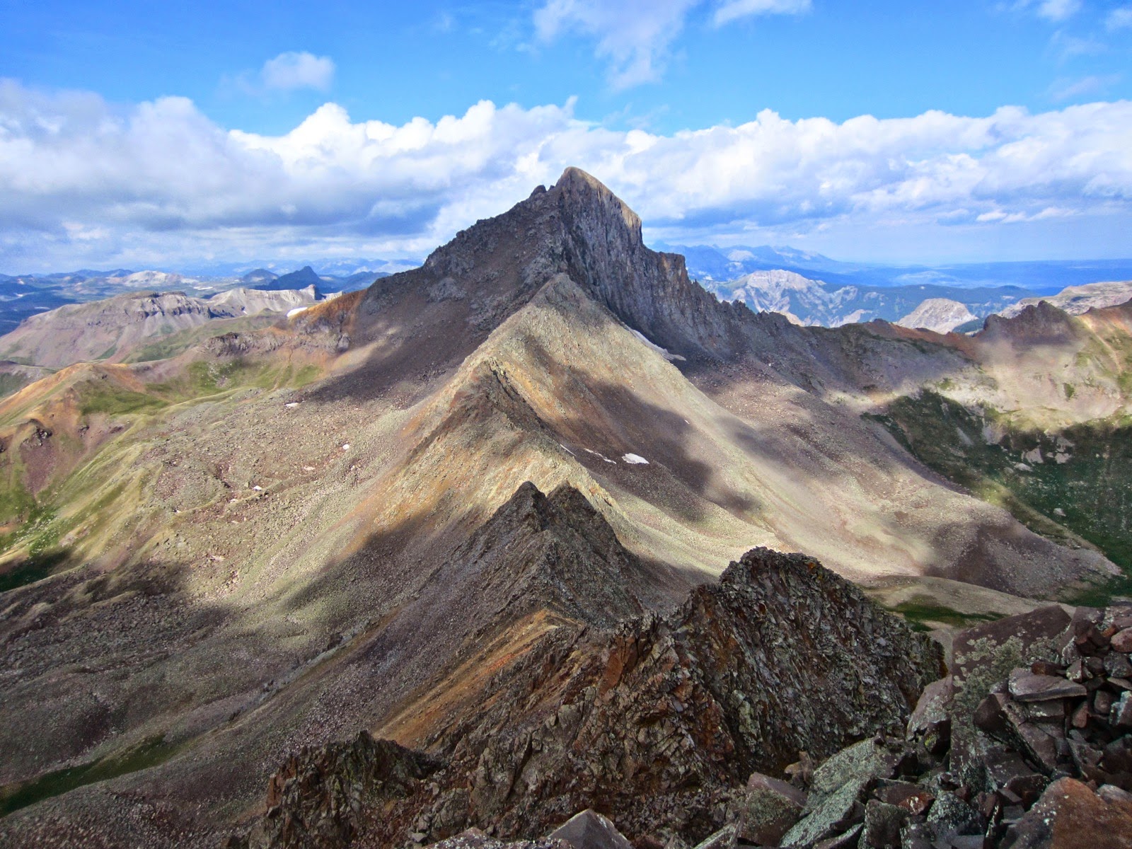
Looking west to Wetterhorn Peak from Matterhorn Peak.
Wetterhorn Peak and Matterhorn Peak Map: This map was drawn free hand without the aid of a GPS. It's not exact, but it is close.

Route: From the upper TH, pass the gate and walk north on the east side of Matterhorn Creek for 0.7 mile to a signed junction. Don't be tempted by the Wetterhorn Cutoff Trail, as likely as it sounds. Rather, take Ridge Stockway Trail #233. It makes a sweeping switchback to the southeast before resuming its northerly course. Trees are left behind at 11,600', exchanged for a day in the tundra. About 2 miles from the TH, just above 12,000', the trail splits. The track to the right leads to Uncompahgre Peak. Bear left. In the image below, Wetterhorn is glowing on a rainy morning presaging a successful climb on an improbable day.

If there is no threat of rain, you may just as efficiently climb the two peaks in either order. Generally, it is best to climb aptly named Wetterhorn, or "Weather Horn," first. Wet rock greatly increases the hazard on this mountain. The hiker below is just past the split with the Uncompahgre Peak Trail. Wetterhorn is on the left and Matterhorn, the right.

The sublime trial turns northwest and then west, ascending to Pass 13,090' in just under 3 miles from the TH. Walk through a town of picas and marmots living in the friendly boulders beside the path.

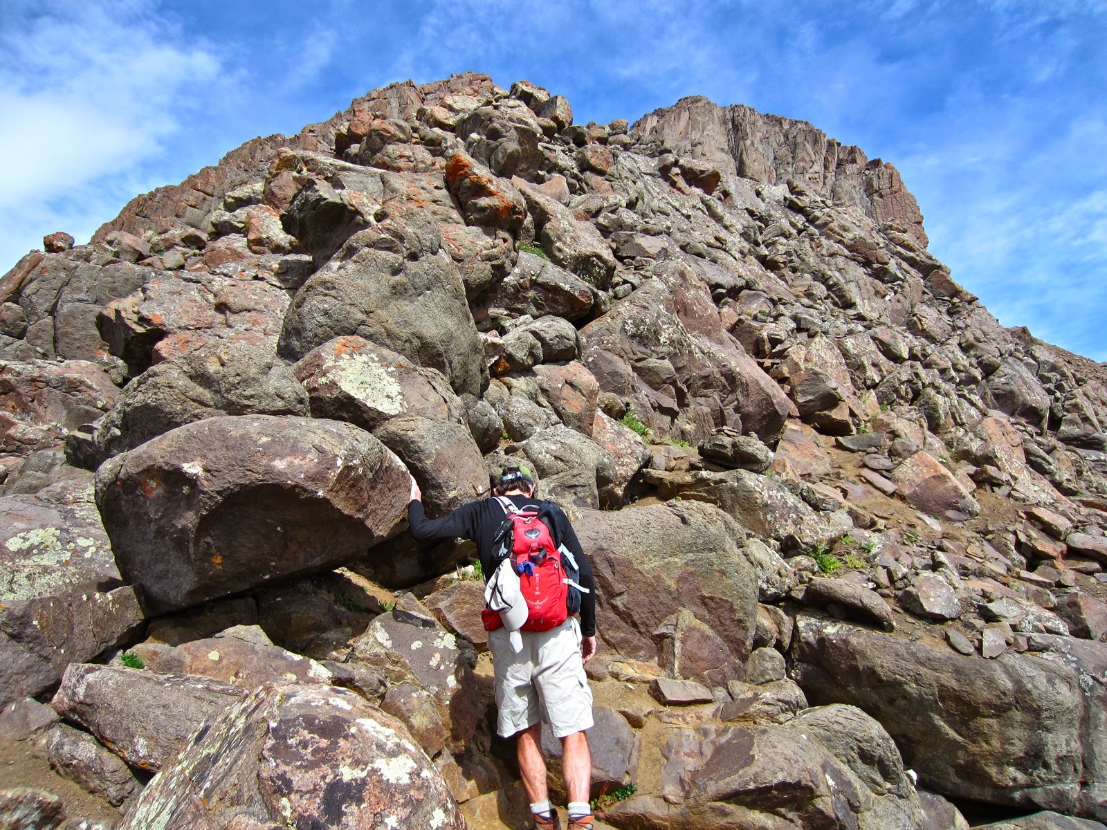
From the pass, shown, the horn is 0.5 mile away with 1,000 feet of climbing remaining. It will take an hour if navigation goes without a hitch. Climb the obvious ridge trail. There are some slippery, steep sections with resistant soil. Enter the boulders; the trail is still clear with no confusion. But soon, you will be faced with many choices, cairns leading in different directions to dubious, braided routes. Look for a large cairn that guides you onto a rising traverse. It goes up the southwest side of the ridge and then onto the rib. If you stay on the original trail too long, you'll get drawn into Class 3+ obstacles and towers that, in fact, will get you there but greatly increase the challenge. For reference, note the so-called Ship's Prow just left of the peak in the image below.

Scramble up the spine. Make it a policy to cling to this ridge, with one exception. Well up the convoluted ridge, you will come to an obstacle forcing you off the rib to the right/east. A few moves and you'll be faced with a choice to either make a seemingly unlikely scramble back to the ridge, or do a cairned lateral traverse. Do the short climb. My notes indicate the lateral was vastly exposed on resistant soil, "15 minutes of terror." Back on the ridge, work your way along the base of the Ship's Prow.
Just north of the Ship's Prow, is an 8 foot barrier with good holds. Usually, there is a cairn on top of the pitch to guide you. On top you are faced with the final challenge, the near vertical, stair-step 150 foot wall to the top. It is in a shallow gully. If there are climbers on this wall, rest on The Ramp while you wait for them to complete their climb. In this photo, the author is descending, facing the rock, as a friend walks up The Ramp. (THW, photo)

While the climb is greatly exposed, the holds are superb, there are plenty of ledges to steady yourself, the rock dependable. This group scaled the wall together because rain was imminent. Some people will prefer the reassurance of a fixed rope.

Looking at the image below, a few feet above the upper climber's white helmet is a horizontal ledge. Go left along this shelf until you reach the ridge at skyline. This move is clear when you get there. Bust up the final pitch to the rounded and generous summit.

The panorama from the crest is as commanding as can be in Colorado--14'er quality. Matterhorn and Uncompahgre are to the immediate east. Just 2.5 miles as the crow flies to the northwest is Coxcomb Peak and to its right, Redcliff, shown.

For the downclimb, return down the spine to the lateral ledge and re-enter the gully wall as these climbers have done. Some moves are best done facing the rock. Note The Ramp and Ship's Prow on the right side of the image.

Pausing on a secure platform while taking turns.

From The Ramp, looking back at friends on the wall. (THW, photo)


Return navigation is considerably more obvious and affords the opportunity to fix what you botched going up! In the image below, climbers have retreated well down the ridge. They are clamoring through boulders towards the large cairn at the trail.

From the trail above Pass 13,090' are incomparable views of Matterhorn and Uncompahgre.

To climb the lovely, beguiling Matterhorn, stay on the main trail wending your way back through the pleasant boulders harboring picas.

Leave the trail at about 12,400' and cut east to intersect the rounded south ridge of Matterhorn. Depending on where you hit it, you will be approximately 0.5 mile and 1,000 feet off the summit. It takes about an hour to span between the Wetterhorn trail and Matterhorn's crest. Simply walk up the slope from one rounded bench to another.

Begin the Class 3, super fun, 300 foot scramble to the summit. Stay on or close to the ridge. After Wetterhorn, Matterhorn feels like a delightful walk in the park.

I have considerable affection for this peak. It seems almost diminutive compared to the massive 14'ers on either side. Since is doesn't measure up to that magic number, Matterhorn is somewhat neglected. Maybe that's a good thing for you are sure to experience solitude on this beautiful mountain. From the top, Wetterhorn is a casual glance away to the West. (THW, photo)

Uncompahgre Peak, 14,309', is so close in the east that very strong climbers can summit the two 14'ers in one day. For an excellent description on how to combine these high peaks, see Gerry Roach, Colorado's Fourteeners: From Hikes to Climbs.

To return to the trailhead, walk down Matterhorn's south ridge 1 mile, dropping to 12,200'. Here you will intersect the very obvious Uncompahgre Peak Trail, not far from where you left it in the morning. Turn right/SSW, retracing your steps 2 miles to TH 10,720'. While walking back, revel in the myriad of experiences these two magnificent mountains gave you. Just think; that's all inside of you now.


