Travel: From Tucson, drive north on Oracle Road, AZ-77. Pass Ina Road and turn right on Magee Road. Go 1.5 miles to the Iris O. Dewhirst Pima Canyon Trailhead. Or, from Ina Road take Christie Drive north for 1.4 miles and turn right on Magee. The generous, paved lot is on the right. There is a drinking faucet but no other facilities.
Distance and Elevation Gain: 9.8 miles, 3,900 feet of climbing for the two-mountain Black-Line Route
Time: 8:00 to 9:30
Difficulty: Trail, primarily off-trail; navigation challenging; no exposure while climbing but breathless exposure at cliff edges; carry more water than you think you will need.
Maps: Tucson North; Oro Valley, AZ 7.5' Quads; or, Pusch Ridge Wilderness, Coronado National Forest, USDA Forest Service, 1:24,000
Latest Date Hiked: November 20, 2015
Pusch Ridge Wilderness Bighorn Sheep Closure: It is prohibited to travel more than 400 feet off designated Forest Service trails from January 1 through April 30, bighorn sheep lambing season. Table Mountain and Bighorn are off-limits during that time period. No dogs, ever.
Quote: This curious world which we inhabit is more wonderful than it is convenient; more beautiful than it is useful; it is more to be admired than it is to be used. Henry David Thoreau
From the left, Cathedral Rock, Table Mountain, and Bighorn Mountain define the eastern earthline over Oro Valley.

Route: Following the Black-Line Route, walk up Pima Canyon Trail for two miles. Leave the trail and head northeast up a broad ridge. Stay near the breathtaking northwest precipice while summiting Table Mountain. Climb Bighorn Mountain before descending on the ridge route. The Blue-Dot Route is suggested if you wish to climb The Cleaver. (Please link to the 2018 Cleaver post for the optimal route.) The Red-Dot Route is the standard gully approach. Note: There are other routes up Table. Technical climbers should check out Crescent Crack, "...clearly observed from Oracle Road as the obvious crack system that cleaves the intersection of the North Buttress and West Face of Table Mountain." Visit: Mountain Project.

From the Pima Canyon Trailhead, elevation 2,920 feet, walk through private land on a thin easement. The treadway is admirably constructed, a pleasant mix of bedrock and dirt. Walking is easy as the path threads its way through a lush jumble of typical Sonoran plants: stands of ocotillo, congregations of the mighty saguaro, brittlebush, verbena, orange globe-mallow, agave, back-lit golden grasses, staghorn cholla, sotol, and prickly pear.
At 0.4 mile, go left at the sign, staying on Trail No. 62 toward Mount Kimball, 7,258', seven miles distant. This is a classic, don't-miss Pusch Ridge hike for another day.

At 0.6 mile the east face of Table comes into sight for a brief time (left of center in this image).

Cross Pima Canyon Wash at 1.1 miles. The drainageway is generally dry and while surface water may be intermittent, don't count on it. Walk under the north face of Rosewood Point. The unmistakable Cleaver comes into view to the north. (Thomas Holt Ward, photo)

Leave the trail at 2.1 miles, about 3,480 feet. This is just past the unmarked turnoff (not an obvious trail) for Rosewood Point and Prominent Point West. Don't just settle for any old place or you will get torn up. The crossing should look rather appealing. Be sure you have a bead on the slabs of Santa Catalina gneiss on the opposite side of the creek, shown, and on the climbing ridge. In 2014, I used the undeniably miserable gully route. By contrast, this ascent is pure delight.

Shindaggers come alive in droves at 4,200 feet. These are agave schotti, not lechuguilla which are prevalent in Big Bend. At 3.4 miles, 5,300 feet, intersect the gully route, shown below. There are multiple ways to attain the summit from here; I've been all over the Table. My favorite is to make directly for the northwest rim.
But first, when you get onto the Table proper, there is a distinctive shift in vegetation associated with changes in the rock. The metamorphic gneiss transitions to granitic gneiss. You will find quartz veins and pegmatite clusters with chunks of mica and feldspar, along with gorgeous nuggets of quartz. As you proceed, there are manzanita thickets, Mexican piñon, and three kinds of oak: silver leaf, Arizona white, and scrub.


Periodically, the route will leave you standing breathless at Table's edge or gawking at a cliff face.

The western edge is the best segment of all. Walking on the rim rock is like being on the roof of a skyscraper, only here, Table is undercut.


You will reach the summit at about 4.5 miles, depending on your route. Walk all along the northern edge of Table for different perspectives on the incomparable vista. Below, I am standing on an airy perch above a 2,000 foot vertical drop. Dominating the lookoff is Mt. Lemmon, Cathedral Rock, and Mt. Kimball. Way off in the north are Four Peaks and Weavers Needle. There is good picnic seating all along the cliff edge. (THW, photo)

If you are not climbing Bighorn Mountain, see the map above for a shortcut back to the gneiss ridge. Bighorn is a quick and pleasant climb from Table. Seen below from the west rim, Bighorn Mountain is the less than obvious prominence in front of Pusch Peak. To hasten the process, from the skyscraper go east of the boulder jumbles and then return to the rim.

Acquire Point 5,462', image center- left, and drop to the low point between Table and Bighorn, elevation 5,350 feet. From here, the east slope of Bighorn is absurdly pleasant with open walking through clumps of sotol and beargrass. Cross to the highpoint at the west end of the summit ridge. Reach it at six miles, elevation 5,660 feet.

The summit register is tucked under a boulder on the west end.
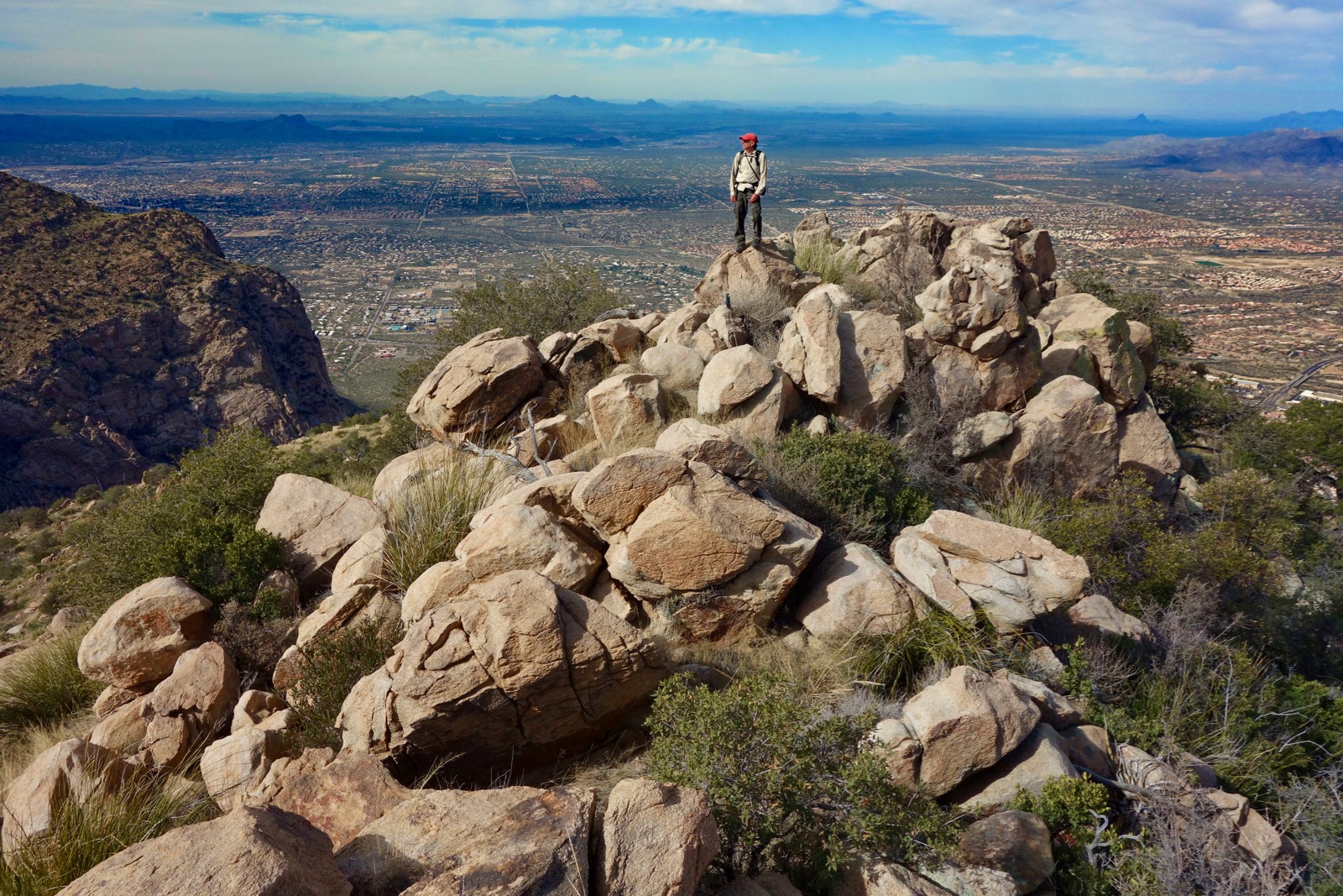
Table and Bighorn get to admire each other all day long.

The best way back to the Pima Canyon Trail is to return to the east saddle and drop to rejoin the upcoming ridge route. All other choices are deeply troubled by unavoidable slicing plants. The Pima Canyon Trail will feel like a paved highway. Savor the wind down.
Blue-Dot Cleaver Route: We had time and energy enough for The Cleaver, Point 4,910', so we descended southeast from Bighorn. Soon we were standing at the base of the blade. We were about to contour around to the northwest (Oro Valley) side when we realized we were essentially out of water. So we dove down to the Pima Canyon Trail on a wretched route, little better than the standard gully. The image below captures The Cleaver and Pusch Peak.
(THW, photo)

Red-Dot Standard Gully Route: If you must adhere to the standard route up Table be prepared to launch into spiky and steep terrain where plants are the fourth dimension. Parry with cutting swords! At 3.2 miles, 4,000 feet, leave the Pima Canyon Trail. Use the landscape for location confirmation. This is the first plausible weakness in the cliffs to the northwest. In the image below, the objective is to climb the gully just right of the metamorphic cliff band on the left, topping out on the grasslands at the horizon.


Start up the slope and then drop into the gully where it is least offensive. We experimented with both sides; the rock is best and there are fewer plants in the bottom of the defile. Wear protective armor because the shindaggers are horrendous. They are hidden under grass keeping company with prickly pear. Cat claw seems tame compared to these sneaky swords. Sure, the route is steep, gaining 1,000 feet in 0.6 mile, but progress is largely slowed because of spear-dodging. Cairns in the trench are superfluous; find your own way. Be snake aware; my hiking partner woke a rattler. Emerge at 3.8 miles, 5,000 feet. From there, do a comparatively soft ascent for about 300 feet to join the ridge route described above.

Birds: We were fortunate to have an ornithologist with us in December, 2015. Here are the birds he identified: curved-billed thrasher, rock wren, cactus wren, rufous-crowned sparrow, house finch, white-throated swift, ruby-crowned kinglet, peregrine and prairie falcons, harrier hawk and red-tailed hawk, bushtit, and Mexican jay.
Table is a distinctive and mighty mountain that garners respect. Here's how it appears from Pima Saddle.

No comments:
Post a Comment