Travel: At Center Street and Main Street in Moab, zero-out your trip meter. Drive north on U.S. Route 191 for 10.8 miles. Turn left/west on Utah State Route 313 South. At 25.1 miles, 313 South goes left to Dead Horse Point State Park. Stay straight. Pass the Canyonlands National Park entrance gate (closed) at 30.8 miles. Show your pass or pay fees at the Visitor Center, 31.9 miles. Continue south on Grand View Point Road. Stay straight at 38.0 miles. Turn right/west into the dirt Murphy Hogback Trailhead parking lot at 40.5 miles.
Distance and Elevation Gain: 12.2 miles, 1,670 feet of climbing
Time: 5:00 to 7:00
Difficulty: Trail, off-trail; navigation moderate; very mild exposure; water is available outside the Visitor Center spring through fall only, carry what you will need; the Park Service rates this hike as strenuous
Fees: In 2015 park fees went up substantially. Please check this link for current fee information. The Visitor Center is closed seasonally. For a snow report during that time, call Park Headquarters, (435) 719-2313.
Maps: Monument Basin; Turks Head, UT 7.5 Quads, Trails Illustrated No. 310, Island in the Sky District, Canyonlands National Park
Latest Date Hiked: November 9, 2015
Quote: Wilderness is not a luxury but a necessity of the human spirit. Edward Abbey
Grand View Point and Junction Butte are but an acute slice of the great circle of the horizon seen from the western end of Murphy Hogback.

Route: Walk southwest on an abandoned road across Island In The Sky to the canyon rim. Descend to a Moenkopi platform. At the trail junction go toward Murphy Hogback, doing the loop in a counterclockwise direction. Upon reaching the White Rim Road, walk off-trail to the western tip of the Hogback. Descend on the White Rim Road to the low point at Murphy Wash. Walk up the wash, close the loop, and return as you came.

Author's Note: Of all the hikes in Island In The Sky, Murphy Hogback is my favorite. It features a continuous vista into immeasurable Western reaches. You will want to go where your eyes take you but much of this vast tract of land is impenetrable, the horizon unreachable. The American West holds mysterious places that only the Earth remembers, quarters off-limits to even the most ardent explorers. The power and sublimity of this landscape will ignite desires that will never be answered.
A wide, level track dusted with sand leaves from the trailhead, elevation 6,240 feet, and heads westerly toward the Henry Mountains. Three groupings of peaks make this range distinctive. The path is bounded by an Indian ricegrass plain dotted with ephedra, prickly pear, yucca, snakeweed, rabbit brush, blackbrush, and mature piñon-juniper.

The route divides in half a mile. The right spur goes to Murphy Point. Go left toward White Rim Road. After crossing a draw, reach the canyon rim. The path turns southeast hugging the drop while it looks for a break in the imposing Kayenta Formation, the sandstone layer that forms the I-Sky mesa top. At one mile the engineered trail plummets into an amphitheater working its way down a series of ledges. Most hikers will find the horizontal shelves comfortable, a few may feel exposed. The image below was taken from the tipoff. It shows a weakness where the Kayenta gave way depositing a swath of pulverized earth and big block jumbles to make this passage possible. A break in the otherwise impenetrable escarpment encircling the mesa is uncommon; surely this is an ancient pathway.

Tread on the ledgerock to the center of the concavity. This image looks back on the walking platforms.

Stone steps marked with cairns weave down the rubble field covering Wingate Sandstone, a cliff-forming layer 400 feet thick.

Cross a boardwalk at 1.4 miles at the contact line between the Wingate and Chinle Formation.

Back on the north side of the drainage, the trackway descends through the slope-forming Chinle. From the time you arrive at the rimrock until you are encased in Murphy Wash, the field of vision is inexhaustible.
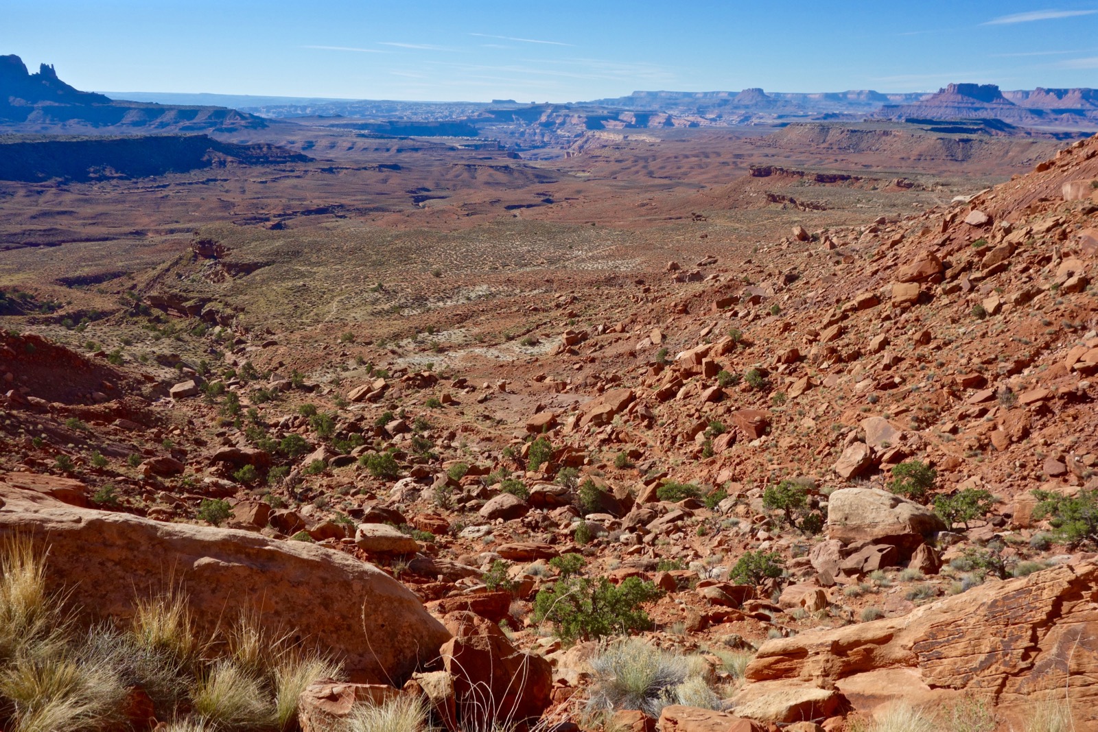
Reach a trail junction at two miles, 5,200 feet. The 6.7 mile loop segment of this hike begins here. There are two ways to reach the White Rim Road: via Murphy Wash (2.7 miles), or Murphy Hogback (2.8 miles). Promise me you will turn right toward the Hogback. By going counterclockwise, you will be walking into the immensity instead of having it at your back. Walk on a Moenkopi Formation platform all the way to the White Rim Road. The predominant shrub is blackbrush. Ekker Butte, image-center, is in the Maze District.

On this day of untroubled air, I walk in an envelope of silence under the protection of cliffrock. Slabs of stone hold up Chinle pedestals. Jump across dusty rose rivulets.

The platform bends southwest at 3.0 miles. Candlestick Tower is off in the north, shown. Navajo Sandstone domes, image-right, stand out because there is so little of this rock layer on the sky island. A short spur steps west to an overlook at 3.6 miles. See Soda Springs Basin, White Rim Road, and even cottonwoods drinking from Green River. Cross the neck onto the Hogback at 3.7 miles.

Upon arriving at the White Rim Road at 4.8 miles, turn left. Our route utilizes 1.3 miles of the 100 mile 4WD and mountain bike route that loops around I-Sky. Murphy Hogback is one of the permitted camping sites and there are pit toilets in this area. I highly recommend doing a 1.5 mile roundtrip spur to the western end of the Hogback. At the crest in the road, turn right/west and walk off-trail on White Rim Sandstone, nature's slab path. The image below shows the narrowest portion.

The peninsula ends at an abrupt drop at these flat picnic rocks. Point 5,301' is beyond the gap. The bubbly forms of White Rim Sandstone are a defining layer. High in the east are the La Sal Mountains. Spin clockwise to see Elaterite and Ekker Buttes. The Green River is the glistening plane of water very close now to its destiny with the principal water carrier of the American West, the Colorado River. Cipher our route between Murphy and Grand View Points. Junction Butte straddles the confluence of our Western heritage rivers. It takes more than a few moments to process this enrapturing landscape.

Upon returning to the road at 6.2 miles, turn right/east and drop off the Hogback.

Murphy Wash, elevation 4,800 feet, is the low point of the hike. Leave the road at 7.5 miles, turning left/north into the wash. Today the waterway is trickling and the coarse sand and gravel floor is wet. Walking is unfettered and fast.

A plethora of drainages contribute to the mazeway and we will employ several of them to find our way out. Be watchful at every tributary; it is essential to get this exactly right. The first junction is at 8.7 miles. A cairn beckons into a side canyon coming in on the left. According to their nature, going upstream watercourses grow smaller and boulders on the floor grow larger. The wash is shallow as it cuts through the Moenkopi Formation. The deposition layers are thin stripes of siltstone and mudstone. Ripples decorate bedrock.

Pass a historic streamside corral enclosed with tin, and thin, standing slab walls at 9.3 miles. The minor wash divides again. Go right at 9.5 miles. Then bypass an eight foot pouroff upcanyon-right. Expect a rubbly channel.

Force of water created a rift in the Moenkopi cap, shown, and the trail takes advantage at 10.0 miles.

There is one more bypass upcanyon-right just before closing the loop at the now familiar junction at 10.2 miles. Remounting the hardscrabble trail, desert varnish on the Wingate gleams black. Top out on the island at rest below the sky.

The La Sal Mountains appear to be just across the road from the trailhead.

No comments:
Post a Comment