Travel: From the US 550/160 intersection in Durango, drive 41 miles north on US 550. One mile before Molas Pass, just shy of mile marker 63, turn right/east at the Andrews Lake sign. It is 0.7 mile to lakeside parking with an outhouse.
Distance and Elevation Gain: 14.4 miles, 3,600 feet of climbing
Time: 7:30 to 8:30
Difficulty: Trail, off-trail; navigation challenging; Class 3 scrambling on ridge with considerable exposure
Map: Snowdon Peak, Colorado 7.5 Quad
Latest Date Hiked: July 5, 2016
Quote: Truly it may be said that the outside of a mountain is good for the inside of a man. George Wherry, 1896
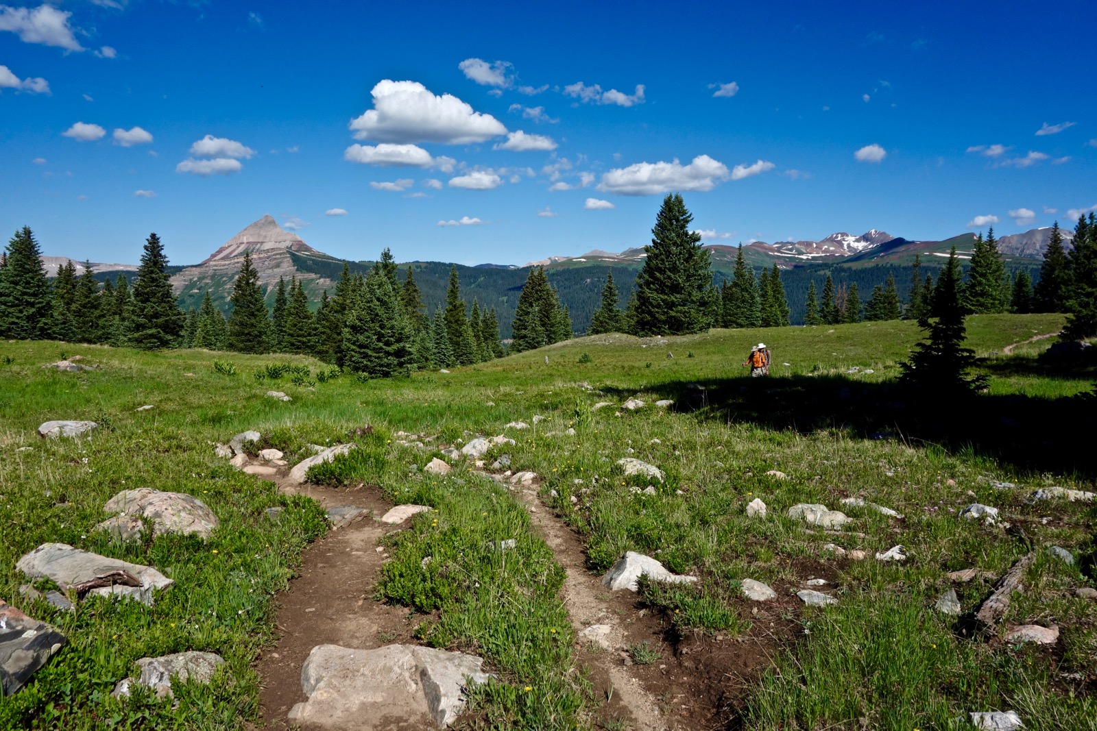
The summit ridge of North Twilight Peak, image-left, may be seen from the shoreline of Crater Lake. (THW, photo)

Route: From the Crater Lake Trailhead at Andrews Lake, walk roughly south for 5.7 miles on a rolling trail to Crater Lake. Climb the northwest ridge of North Twilight to the junction with the east ridge. Scramble west a half mile to the summit.

On a solo hike years ago I attempted to climb North Twilight directly from the lower east ridge and got cliffed out. This detail map delineates the proper route from Crater Lake. The blue-dot alternative offers a slight refinement.

From the trailhead at elevation 10,750 feet, walk south and cross the bridge on the west side of Andrews Lake. Step up to the right onto a generous, well-engineered, heavily compacted trail. The treadway enters the Weminuche Wilderness and then switches up through deep woods decorated with a diverse array of wildflowers. This image looks over the reflective lake favored by anglers to the parking lot and the Grand Turk group to the north. (Harding Cure, photo)

The trail climbs gently, gaining 450 feet over the first mile to a junction and trail register; bear right. (The left path leads to Snowdon Meadows and eventually to Snowdon Peak.) Pass a marshy, reed-spiked lake and corn husk lilies growing in linear patterns. Enter the forest at 1.5 miles and switchback downhill, bottoming out while crossing a creek at 1.8 miles, 11,000 feet. The trail gives up elevation twice on the way to the lake for a total of 500 feet. Be mentally psyched to make this up on the way home.
There is much to appreciate on this long approach to the mountain. Pass limestone bedrock runners and wander in and out of a healthy conifer forest. Expansive openings afford wild and spectacular views of Engineer Mountain. A local's favorite, the peak is featured throughout this hike. In dappled woods find columbine, geraniums and heart leaf arnica. In meadows, burnt orange agoseris and the uncommon red windflower. In wetlands, elephant head and marsh marigold. And by streams, Parry's primrose, caraway, and brookcress.
It is important to make good time on the gorgeous but long approach hike to Crater Lake. The first good look at North Twilight Peak comes at 3.2 miles in open territory.

At 5.4 miles, pass a pond in the center of a lake that has turned into a meadow. Reach Crater Lake at 5.7 miles, 11,640 feet. I'm booking it here but this is the place to pause and analyze your route. The image below shows the climbing ridge with North Twilight Peak on the right. The next objective is the high green knob in the center of the image. Gain it by way of the northwest ridge. (Harding Cure, photo)

Walk along the east side of the lake, very shortly leaving the main track and going left on a social trail that punches through some willows. As indicated on the detail map, on our most recent trip we left that secondary trail at 5.8 miles and climbed off-trail on the green slope pictured below to a prominent meadow. Alternatively, from the lake, follow the secondary trail toward the saddle. Just before a pond, angle off to the right. Cut through trees and willows for a short distance and enter the meadow.

Walk southwest across the meadow to the low ridge on the right.

This image was taken from the low ridge. From here the landscape directs onto the northeast ridge proper.

Gain the northeast ridge at about 6.2 miles, 12,000 feet. By 12,100 feet, a use trail is quite obvious. This ridge is one of the more remarkable segments of the hike. It is narrow in places with beautiful natural steps, exuding a sense of security and pleasure. The path goes under a cliff band on the east side.

The wildcat trail leads onto a steep slope of mixed vegetation and dirt. Climb west-southwest for 250 feet.

At 6.6 miles, 12,800 feet, reach the east ridge of the mountain. Turn right and climb to the top of the rounded knob.

You will be drawn magnetically onto the short, east ridge knife. As always, stay on the ridgetop unless forced off by obstacles, thereby increasing exposure. There is some flexibility in bypass choices; find a route that feels best to you. Allow 35 to 45 minutes to cover the next half mile to the summit. Test all holds.

Here's a look at the initial knife from a different (and more artistic) perspective. (THW, photo)

The next four images were shot on the return trip. They render a better look at the obstacles. Bypass on the south side of the first gendarme, a flatiron. Then get back onto the ridge.

Soon the ridge cliffs out. This image shows the go-around on the north slope. Use caution.

Stand in the gash. Next, you will be climbing toward the camera. Remember, this image was snapped on the return trip so you will be ascending whereas my friends are descending. There is evidence of much travel on the south slope and most of us went that way. However, this choice is seriously exposed and the footing is poor. It would be preferable to scale right up the spine where my climbing partner is standing, image-left.

Now downclimb a rounded outcrop and drop into the third gash, pictured. In 2010, we scaled straight down the nose. However, a huge boulder has fallen away from the landing and the remaining rock has large fissures ready to cut loose. Therefore, work your way down on the north side, staying as close to the nose as possible. Again, this image was taken on our return.

Next, scramble up a little knob that will feel nicely protected. You are home free on the extraordinary spacious and flat summit block.

Reach the 13,075 foot crest of North Twilight Peak at 7.2 miles after 2,660 feet of climbing. It is stunningly gorgeous, a unique location. West is Greyrock Peak and Engineer Mountain, pictured; US 550 goes on its wandering way far below. Snowdon Peak, out of image-view to the north, is only two feet taller than North Twilight. It is the northernmost prominence in the West Needle Mountains.

Directly south is Twilight Peak, South Twilight Peak, and the eponymous West Needle Mountain, right to left.

The best view of the mind-bending peaks across the Animas River trench is from the knob half a mile east. Here's the lineup seen in this image starting on the left: Jagged Mountain, Peak 10, Knife Point, Animas Mountain, Peak 13, Monitor Peak, Sunlight Peak, Windom Peak, North Eolus, Pigeon Peak, and Turret Peak tucked behind. Ruby Lake is image-center. (Chris Blackshear, photo)

The northeast ridge descent affords an excellent overview of the return route to Crater Lake.

Catch a brief and final glimpse of eastward peaks while passing through the big meadow. Earth effortlessly and endlessly manages to pull off the union of opposites. (Chris Blackshear, photo)

No comments:
Post a Comment