Travel: From Durango, drive north on US 550 about 47 miles to Silverton. Continue north toward Ouray for two miles. At the sign for the South Mineral Campground, bear left onto a good dirt road. In 4.3 miles, pass the Ice Lake Trailhead. The next two miles require a 4WD, high clearance vehicle. Park in a turn-out on the right at 6.6 miles at the Bandora Mine. Note that the road splits here. The left branch goes down to the South Fork of Mineral Creek and the right branch is closed to vehicles and serves as the Lake Hope Trail. Allow 1:30 from Durango.
Distance and Elevation Gain: 5.0 miles; 2,960 feet of climbing
Time: 5:00 to 6:00
Difficulty: Primarily off-trail; navigation challenging; Class 2+ with some lower Class 3 and serious exposure between the peaks.
Map: Ophir, Colorado 7.5 Quad
Latest Date Hiked: July 29, 2016
Quote:
There was a time when meadow, grove, and stream
The earth, and every common sight
To me did seem
Apparell’d in celestial light
The glory and the freshness of a dream.
Wordsworth
Vermilion Peak, 13,894', Fuller Peak, and Beattie Peak from Peak 13,302'. (THW, photo)

Route: Beattie Peak, an off-the-radar mountain, is appropriately difficult to navigate. The black-line route is the best I can offer. From Bandora Mine, climb northwest up a steep pitch for about 800 feet. Head west, curving under Pt. 12,635' and ascend the Beattie/Fuller basin to Saddle 13,020'. Climb south to Beattie Peak. Walk 0.7 mile across a slender ridge to Peak 13,302'. Descend the friendly southeast ridge to the Big Three Mine, intersect the Lake Hope Trail, and hike east to the start. From a navigation perspective it might very well be easier to do this circuit clockwise instead of counterclockwise as I describe.
Route Variations: I have climbed the southwest ridge of Peak 13,302' from Hope Pass, continued to Beattie and returned to bail into the basin below their joint saddle. Loose rock at the angle of repose makes the ascent to Peak 13,302' rather atrocious but the last 100 feet up the skinny southwest summit ridge is stellar. This would be a better descent route. Likewise, dropping into the basin from the Peak 13,302'/Beattie saddle worked nicely but sliding scree would make it a poor ascent option.
The southeast ridge of Beattie Peak looks technical if not impossible. Cliffs complicate achieving the Beattie/Fuller basin starting from the Lake Hope Trail from points west of Bandora Mine, though it has been done.
Finally, a viable social trail connects the Beattie/Fuller saddle with the Vermilion/Fuller Saddle at the head of the Ice Lake Basin. On the map below, Peak 13,300' should read Peak 13,302'.


Walk east up the road directly under the mine. Bandora produced gold and silver from 1890 to 1940. You will walk through some of the 35 gallons per minute of orange discharge high in zinc and manganese. In 2016, the inactive mine was listed as a Superfund site after it was determined there is a significant risk of a blowout. This image looks back on the mine and Rolling Mountain southwest of the South Fork of Mineral Creek.

Bear northwest up a steep, plant-covered slope staying close to the edge of the creek defile. This is the sweet spot. If you wander even a little too far west the gradient is even steeper in the conifers. At 10,900 feet enter a thick aspen stand. You can pull yourself up using their little trunks. The surface is choppy broken rock.

At 0.5 mile, just under 11,600 feet, begin curving left/west through heavy woods below the southeast ridge of Pt. 12,635'. After crossing a creek encounter some willows to timberline. In 2012, we nailed this and walked in the green zone just below the talus runoff. In 2016, we angled west too soon. It worked but it wasn't elegant. This image was taken from the Beattie/Fuller basin looking back on the contact between talus and vegetation below Pt. 12,635'.

The correct basin is characterized by Pt. 12,635's unforgettable craggy ridge on the east. Efforts to climb this went unanswered. On the west is the gendarme-prone, blocky southeast ridge of Beattie Peak. When you first enter the basin, it is Fuller Peak that dominates the scene.

A series of benches and softly rounded stone knolls structure the stunning basin. Rivulets flow in lattices, the ground is saturated, and flowers grow in crazy abundance. We saw four deer foraging.

Transition from tundra onto a gently rising field of stone. It pitches up just below the Beattie/Fuller saddle. (THW, photo)


Crest Beattie Peak, 13,342', at 2.0 miles. It is an unglamorous round rock pile with a glorious view. In this eastward image, I am drawing our route on my map as East Twin Sister rises above. (THW, photo)

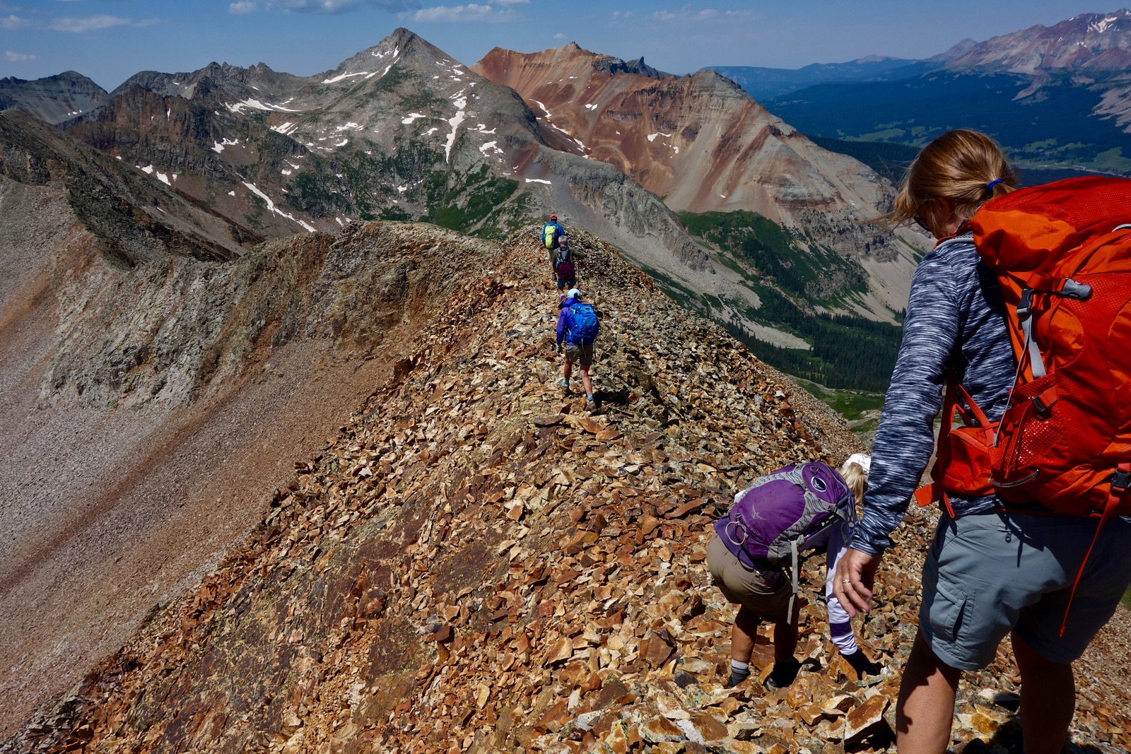
Rock formation changes and the next segment is on lichen-covered, dependable stone. Walk in a slight depression protected on both sides. Peak 13,302' is image-left.

The ridge narrows but the stone is chunky with reliable holds. Notice effervescent Lake Hope. Personal note of caution: On a two-foot-wide stretch, a rock rolled from underfoot and I crashed hard, gashing my leg and clobbering the right side of my body. I was extremely fortunate to land on stone and not sail off into thin air. With fierce determination I was able to pull myself together and finish the hike (I was leading). Please take care and hold your concentration.

Elation follows naturally on this playful ridge.

This lower Class 3 move can be taken over the top or off to either side. This bruiser of a dog had many freak-out moments and needed reassurance and assists on the ridge. Dogs are not recommended.

Reach the saddle at 2.4 miles, 13,002 feet. (If for any reason you need to escape the ridge, I have descended from here no problem.) Come to a distinctive place where the spine projects like a fin terminating in a 12-foot vertical drop. Backtrack and go around the fin on the right/west. Watch the exposure.

You are now at the base of the summit block which presents in two sections. For the first, either get back on the ridge or climb snug against it on the right.

Then confront the most hazardous part of the entire climb, a very steep dirt chute with about 75 feet of vertical. One featherweight friend successfully climbed the boulders on the left/southeast side (image-right). Use caution and check for stability. If you go up the dirt pitch, use the rock on the right for holds (left of the climbers in this image). Some of the stone flakes are well seated; others will detach in your hands. Foot anchors are few. The remainder of the climb is easygoing.

I am topping out on Peak 13,302' at 2.7 miles. The Wilson group is behind me in the northwest. Trout Lake is only a few miles away. (THW, photo)

This image shows the southwest ridge before it plummets on scree slopes to Hope Pass. Grizzly Peak is image-left with V10 on its right.

Directly south is the summit of Rolling Mountain with one of its subsidiary peaks further west. We are seeing just the vertically striated northface of this magnificent structure that does go happily on and on.

Our return route stays on the southeast ridge clear to the Big Three Mine. This ridge is incredibly enjoyable with a mix of large talus and massive boulders. It would be an excellent ascent passageway. From quite near the top you can spot the Big Three Mine and take aim. In this image, the orange tailings pile is in the green below the grey ridge.

Arrive at the Big Three Mine at 3.5 miles and turn southwest on the spur road which accesses the mine from below. Go downhill for less than 0.1 mile and intersect the Lake Hope Trail coming from the Bandora Mine; turn left. If you nail this track it is highly efficient and avoids major willow bashing. The path through a wildflower corridor makes one switchback and crosses several streams before terminating at the Bandora Mine.


4 comments:
Hey Debra, noticed a discrepancy. UN13300 is not V8 according to LoJ, Summitpost, and Roach (2018). San Juan Mountaineers Guide (1932) actually shows V8 as West Turkshead Peak. Peakbagger is the source of the error and I have notified them.
Interesting! Roach changed the designation from "V8" to "Point 13,300" (rank 403) between the 1st and 2nd editions. In his 1st edition, Roach ranks the peak 402 and refers to Beattie Peak as the parent. Lists of John just says "13,300". Caltopo's MapBuilder layer says "V8". It also designates the next thirteener to the south as “V9”. The SummitPost Beattie entry mentions it as "V8". I first climbed the Beattie-V8 pair in 2012 with a friend who recently finished climbing all the San Juan thirteeners and he maintains “V8” is correct.
Ah, I can see how the confusion propogates if Roach's 1st edition was in error too. I have a copy of the San Juan Mountaineer's Guide which is the definitive source of not only the V peaks but also the T (Telluride) and S (Sneffels) peaks. I would be willing to send photos of pertinent pages from SJM Guide if interested but not sure how to do in this blog format.
Brian! I concede...in the face of an authority much greater than I: the San Juan Mountaineer's Guide. I have revised this post and thank you for your diligence in keeping this blog accurate. Debra
Post a Comment