Travel: The Rincon Mountain District of Saguaro National Park is accessed via Old Spanish Trail in eastern Tucson. Once through the entrance station, take the first right, following the sign for the Javelina Picnic Area. The Tanque Verde Ridge Trailhead is on the right as you enter the picnic circle, 1.6 miles from the park entrance. There is an outhouse but no water at the trailhead. Water is available inside the park only at the visitor center and nearby ramada.
Distance and Elevation Gain: 18.0 miles; 4,700 feet of climbing
Time: 7:00 to 10:00
Difficulty: Trail; navigation easy; no exposure; one easy Class 3 move on the summit block; carry all the water you will need; no dogs; avoid in summer heat.
Saguaro National Park (East) Hours and Fees: Open to vehicles 7:00 a.m. to sunset. Walk or bike into the park 24 hours a day.
Map: Trails Illustrated No. 237, Saguaro National Park
Latest Date Hiked: March 10, 2017
Quote: If you wish to know the divine, feel the wind on your face and the warm sun on your hand. Buddha
A hiker gazes southwest toward Mt. Wrightson and Baboquivari Peak from the wide-open summit block on Tanque Verde Peak. (THW, photo)

Route: From the Tanque Verde Ridge Trailhead in Javelina Picnic Area, the trail bears southeast to gain the ridge; then it heads northeast following the divide. The track leaves the ridge after six miles, crosses Box Canyon and then passes by Juniper Basin Campground. The route rejoins the ridge near the summit. Tanque Verde Ridge Trail continues another 2.5 miles past the peak to Cow Head Saddle where it intersects the Douglas Spring Trail. This description assumes an out-and-back to the peak.

From the trailhead, elevation 3,100 feet, backpackers can segue onto trails that penetrate the far reaches of the Rincon Mountains. The trackway to the peak is generally excellent and easy to follow.

Immersion in a lush Sonoran garden is immediate. The pounded, crushed granite walkway plunges into the Cactus Forest featuring 25 species of cacti including the immediately obvious: prickly pear, ocotillo, purple staghorn cholla, and a mighty battalion of breathless behemoths. Mesquite, palo verde, and jojoba shade springtime wildflowers: exuberant dyebush, fragrant ragged rock flower, orange desert globemallow, wild hyacinth, desert chicory, the ever-present brittlebush, and vibrant pink beardtongue penstemon. The pure desert introduction precedes the wilderness boundary at 0.2 mile, indicated with a trail register. The path kicks up on bedrock, wandering through stone formations. Tanque Verde Ridge is comprised primarily of 1.4 billion year old granitics. The image below was taken on the return trek.

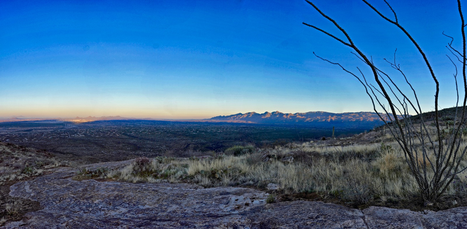
The trail penetrates the ridgetop at 0.9 mile, 3,500 feet, and turns northeast. There is no shade from here to Juniper Basin unless you go looking for it. At first-light, distant ranges are submarine blue-purple. At 1.5 miles, sheets of bedrock constrain a world of grass. The field of vision opened just as the sun illumined the Catalina Mountains and powered up the Tuscon Mountains. (THW, photo)
The path wanders on and off-ridge, sometimes to the south but mostly north. It skirts a rocky knoll and returns to the crest at 2.7 miles, 4,580 feet. And right there, where saguaros are maxing out in elevation, lives a cristate, one of the National Park's candelabra-crowned saguaros.

Plant-life transitions are so seamless, mid-altitude grasslands take over without notice. The columnar giants are gone and in their place are sotol, shindagger, and beargrass living in luxuriant fields of diverse grasses that change with elevation. First is the golden and creamy knee-high cover crop; then the finger-tip tall gangly grass with long seedheads; one variety is rusty-red and flat-bladed; and higher up the hill is the low-lying, wispy, almost invisible fairy grass. The grass at your feet is one of the best features of the hike. And yet, with every step the ever-changing vista is increasingly commanding. (THW, photo looking back)

Tanque Verde Ridge is broad for the duration. When viewed from the Catalina Range, it gains altitude in a series of undulations. Give up 40 to 100 feet at minor divots while progressing upridge. The descents feel great in the morning but be psyched for 450 feet of climbing on the return.

Traipse through bedrock and boulders. Grassland transitions to a scattered woodland as manzanita and alligator juniper take hold. The stately Arizona oak shown below is a 1989 Chiva Fire survivor. A prominent ridge runs parallel on the south forming the opposing containment of Box Canyon; its headwaters flow through Juniper Basin.
(THW, photo)

At 5.9 miles, just as the trail approaches the base of Pt. 6,300', it surrenders the ridge and descends into Juniper Basin. While persisting with the ridgecrest is tempting, it soon becomes tower-ridden and impractical.

Give up some vertical and cross Box Canyon on stone slabs guided by cairns. After an unusually wet winter there was beautiful water in the normally stone-dry drainage.

There is an outrageous mammillaria, or pincushion cactus, beside the trail. Alas, you'd have to be here in early summer heat to see it covered in blossoms.

Arrive in Juniper Basin at 6.9 miles, 5,980 feet. As the name implies, the juniper forest is resplendent. A backcountry permit is required to stay overnight in the campground. There is a communal outhouse. The food-storage box keeps cougar, coyote, javelina, and black bear from nabbing your stash. Water can be skanky or non-existent so inquire before backpacking.

The Tanque Verde Ridge Trail continues northeast. A sign updates mileages. Tanque Verde Peak is 2.1 miles away and Cow Head Saddle is 4.6 miles. From Juniper Basin to the peak, walk in the dappled shade of a piñon-juniper forest complimented by oak. Tacked to trees are orange metal blazes from a bygone era. While they are sporadic, we found them exceedingly useful in finding our way one January day when the ground was snow-covered.
The well-trodden path crosses the main tributary of Box Canyon not far from the campground. It remains on the southeast side of the wash to the ridge. Every now and then the peak is revealed as well as complicated ridge structures. The friendly trail steepens intermittently. Cross a fence line at 6,280 feet. The view corridor opens at a swath of bedrock. This image shows pyramidal Rincon Peak and Happy Valley Lookout to its left.

The trail weaves through bulky sitting boulders and columnar standing rocks as it closes in on the ridge. Towers guarded by manzanita are characteristic in southern Arizona at altitudes in the realm of 7,000 feet.

Glimpses of the summit block are frequent if you know where to look. Below, the peak is in the stony cluster on the right.

At 8.7 miles the trail regains the ridge. At a brief opening, the clear-eyed will see the metal summit post. From here, the trail was over-grown with manzanita so watch carefully. The ridge falls off to either side so it'd be hard to get lost. In a tiny clearing a signed junction points left to Cow Head Saddle. The main trail continues along the ridge as it drops for 2.5 miles to the saddle shared by Tanque Verde Peak and Mica Mountain. The peak is on a spur straight ahead. An historic sign with faded white lettering points the way.

The peak register is located at the base of the summit block. Do a short friction climb up solid rock with grippy features. Once, when the stone was snow and ice-covered, we circled a few feet to the south and scrambled up on dry rock. Don't let this playful Class III opportunity dissuade you from the zenith.

Summit Tanque Verde Peak at nine miles exactly. This is a fortuitous prominence. The boulder stack is climbable and, in this woody terrain, it could easily be a high point without a proper view. There is room for five to six people on the small and distinct weathered summit block. A second peak register is in an ammo can tucked in the rocks. Elevation gain so far is a mighty 4,250 feet.

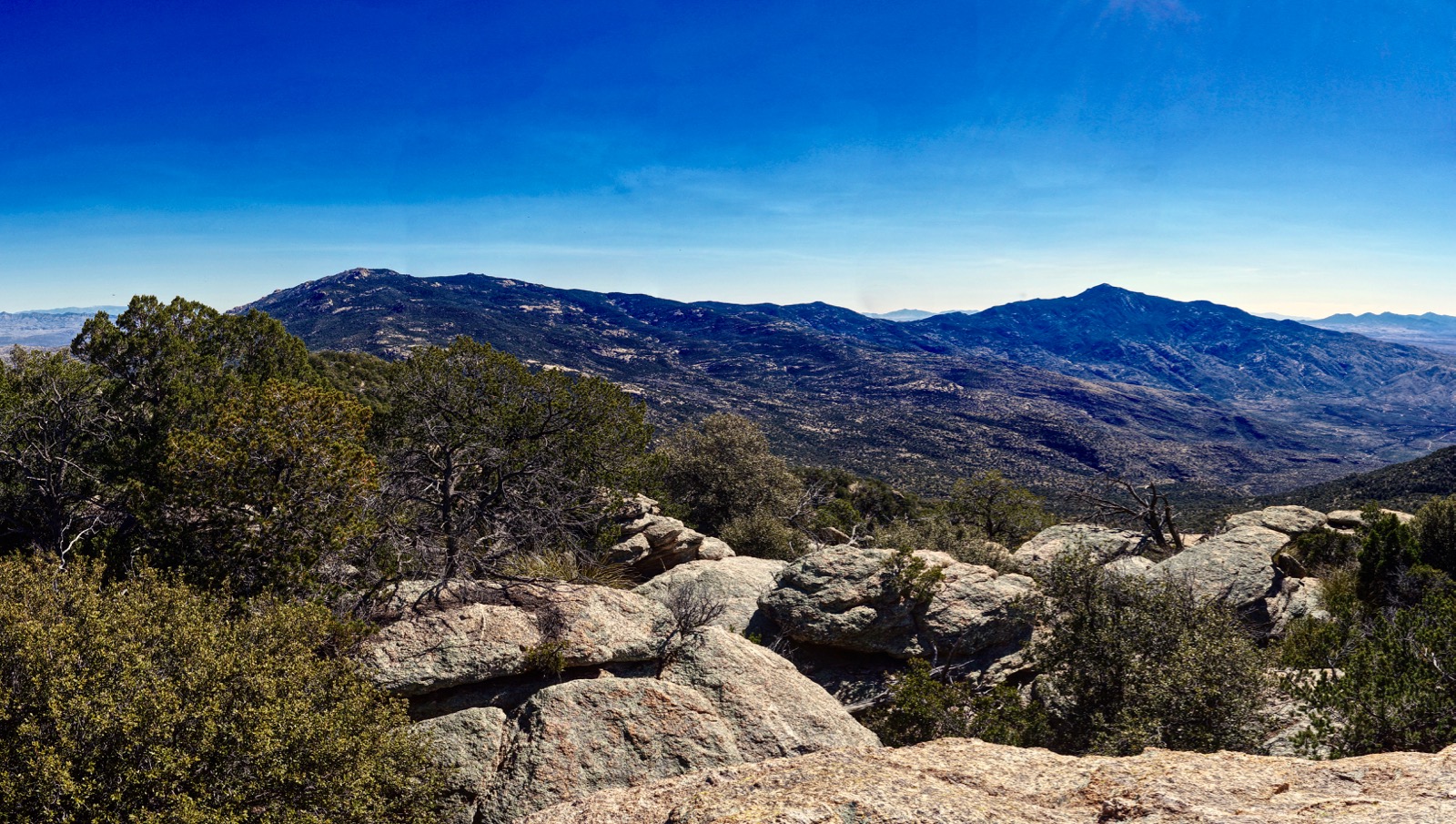
The view is all-encompassing. The mountains in Mexico are off in the deep horizon. The Pinaleño Mountains reside east of the Galiuros. Together, they look like range waves. The Santa Catalina Mountains angulate northwest in a mind-bending manner with Agua Caliente Hill holding down a central position between here and there. The Santa Rita Mountains are close enough to see winter's lingering snowpack. The city of Tucson monopolizes the valley floor. The striking geometry of the Rincon Mountains is portrayed in the image below. Mica Mountain is on the left with the greatest heft and height. (THW, photo)

From the lower ridge, look down on Javelina Picnic Area and Cactus Forest Drive. Even the transition from idyllic desert to city streets appears seamless after a full day of walking, awareness captivated by nature.

No comments:
Post a Comment