Travel: The Whetstone Mountains are south of I-10. From Tucson, in a 4WD high clearance vehicle, drive east on the interstate to Vail. Exit onto State Route 83. From here allow 1:40 to 2:00 to the end of the road and beginning of the hike. Driving south on Highway 83, pass the right turn toward Madera Canyon and proceed through a check point (operational in 2017) and up a hill. Just past mile marker 40 (18.7 miles from I-10), turn left at a brown sign for Empire Ranch Historic Site and zero-out your trip meter. From here, the going is slow and sometimes confusing. We went off on the wrong track more than once. I attempt to give accurate mileages but yours may vary. Find a map of our road track at the end of this post. The road is paved at first but soon turns to dirt. Further on it is impassible when wet. Enter the Las Cienegas National Conservation Area, a wildlife refuge.
3.1 (miles) Stop sign at T junction. Turn left on Bureau of Land Management Road 6901 toward Oak Tree Canyon. Roll through open grassland and a mesquite bosque. Cross Cienega Creek.
7.5 Hook a sharp left. This keeps you on 6901.
8.6 Y intersection, go left staying on 6901. The road rises on a ridge. At the next T junction turn right.
9.6 Go under power lines and left down a hill. Cross Wood Canyon and then crisscross a (hopefully) dry wash several times in the next annoying and rocky three miles. Climb out of the drainage.
12.8 Turn left at another T intersection notable for a large, water-filled round concrete trough. The track descends and then degenerates while crossing a wash with large stones.
14.4 Stay straight at the signed left turn to Apache Spring.
16.2 Open and close a gate.
17.5 Open and close a second gate
18.3 Caution! The track abruptly ends at a small berm protecting a dropoff. This is the end of the road and the parking area.
Distance and Elevation Gain: Apache Peak is 4.8 miles roundtrip with 2,400 feet of climbing. Add French Joe Peak and it's a total of 6.3 miles with 2,960 feet of vertical.
Time: 6:30 to 8:00 for both prominences
Difficulty: Off-trail; navigation challenging; Class 2+ scramble on French Joe summit block; no exposure; protect against brush; rocks roll under foot much of way making it more rugged than the stats would indicate.
Map: Apache Peak, AZ 7.5 USGS Quad
Date Hiked: November 30, 2017
Quote: I pace the shallow sea, walking the time between, reflecting on the type of fossil I’d like to be. I guess I’d like my bones to be replaced by some vivid chert, a red ulna or radius, or maybe preserved as the track of some lug-soled creature locked in the sandstone--how did it walk, what did it eat, and did it love sunshine? Ann Zwinger
The limestone summit block of French Joe Peak is a fun scramble. South are the Huachuca Mountains and further off is Mexico. (THW, photo)

Route: From the parking area, elevation 5,400 feet, drop into Apache Canyon and walk east. The dry creek branches twice; we went right both times. We essentially went due east, climbed out of the drainage, and gained the southwest ridge of Apache at 6,400 feet. It's a straight shot up the ridge to the peak. To reach French Joe Peak, follow the south ridge of Apache.

The image below was taken from the end of the road. Study the terrain and plot your course before commencing. There are other routes to the peak but ours was direct, protected our elevation gain, and stayed mostly in the grass. Within Apache Canyon we went right at two forks. We climbed out of the creek bed and went up the golden slope, right of image-center. It steepens and gets a little greyer before joining the southwest ridge. We moved up the spine, passing the knob, image-center, where we saw Apache Peak for the first time.

Locate a social trail off the left side of the berm. It dives down into an intimate dry waterway lush with mature riparian vegetation: sotol, beargrass, clematis, massive alligator junipers, an Arizona oak draped over the canyon, Mexican piñon...and poison ivy. All the living things were clearly happy on the canyon bottom.
At 0.2 mile, the drainage divides at two falls, each about ten feet tall. We scampered up the barrier on the right because it looked much more appealing. (The jump on the left was choked.) As it happens, this choice served our route well.

One of my companions is a geologist and he was somewhat baffled by the rock. There are bedding planes with fossilized mud tracks in sandstone, indicating sedimentary formation. And yet there are also fine-grained igneous intrusive rocks.

At half a mile the wash divides once more and we bore right. Brush wasn't a problem and we made good progress. At 5,560 feet, 0.7 mile into the hike, we climbed out of the canyon bottom, still bearing east. We scaled a rocky grass slope troubled with catclaw mimosa. Gaining elevation, the piñon-juniper woodland included spherical one-seed junipers. We were directly south of the east fork of Apache Canyon and a symmetrical hill, elevation 6,220 feet.
The land flattens ever so briefly at 6,060 feet, shown. There's no way to avoid a tangled northwest-facing oak-juniper slope that rises steeply for 340 feet to join Apache's southwest ridge. Baby heads have a tendency to roll underfoot. (THW, photo)

This image looks back on the route thus far from the southwest ridge at 6,400 feet.

An historic and picturesque barbed-wire fence runs up the ridge clear to the summit. Juniper stakes and large stone weights keep it in place. This image looks west to Mt. Wrightson.

Structurally, the Whetstones are relatively simple, consisting of a westward tilted fault block of monoclinal Paleozoic strata. Permian limestone occurs on the west flank of the mountain The oldest rocks are low on the east flank. For example, Kartchner Caverns exists entirely in the older Mississippian period.
First we happened upon calcite rhombohedrons within the limestone formation. Then small fossil nodules. And then this perfect nautiloid fossil.

Further along we found a brachiopod fossil.

This stone holds a horn coral and crinoid fossils.

At 7,100 feet, a ridge joins from the north. This is one of the documented routes up Apache. On our return we debated descending this ridge and going over the aforementioned 6,220 foot hill, but the route looked even more choked and we'd have to give up some elevation.
At 7,200 feet, crest the knob identified from the parking area. It presents as inconsequential but here the summit is revealed for the first time. The subsequent slope is loaded with fossils.

Vegetation on the ridge includes mountain mahogany, cane cholla with yellow fruits that look like flowers, Engelmann prickly pear and shin daggers, Schott's agave. Southeast Arizona is considered Chihuahuan Desert so we thought the daggers might be lechuguilla. And while lechuguilla is an indicator plant for the Chihuahuan Desert, it doesn't grow in Arizona. At 7,500 feet, we spied this sunny yellow Schott's agave, a late bloomer. (THW, photo)

Reach the hard-fought summit of Apache Peak at 2.4 miles; there was a peak register in 2017. This small zenith, topped with a little pile of limestone chunks and graced with astonishing views, is the highest prominence in the Whetstone Mountains.
Southern Arizona is basin and range topography. The valleys tend to be wider than the sky islands. Water on the east side of the Whetstones sheds into the San Pedro River; east of the river are the Dragoon Mountains. You can see Mount Glenn, the highpoint, and Rockfellow Dome. Runoff on the west side drains into Cienega Creek. Mount Wrightson dominates in the Santa Rita Mountains to the west. The Rincon Mountains reside to the north and the Huachuca Mountains (and Mexico) are south. Other note-worthy prominences are Baboquivari Peak, Mt. Graham, and the Chiricahua Mountains.
There is only one hiking trail in the Whetstone Mountains. It is accessed from Kartchner Caverns State Park in the eastern foothills of the range. It tops out at 5,620 feet.
Looking northeast from the summit, note the tilted up bedding planes. Some are favorable for vegetation growth, others not. This creates a visually striking ric-rac pattern, shown below.

French Joe Peak
Most hikers will wish to turn around at Apache Peak. French Joe is not a legal summit and the tangled mass of vegetation between the peaks is irritating. Even so, I'm glad I bothered because French Joe has its charms. It is 0.7 mile between the peaks and adds almost 600 feet of vertical overall. This image was taken from Apache and shows French Joe and a broad southern swing. (THW, photo)

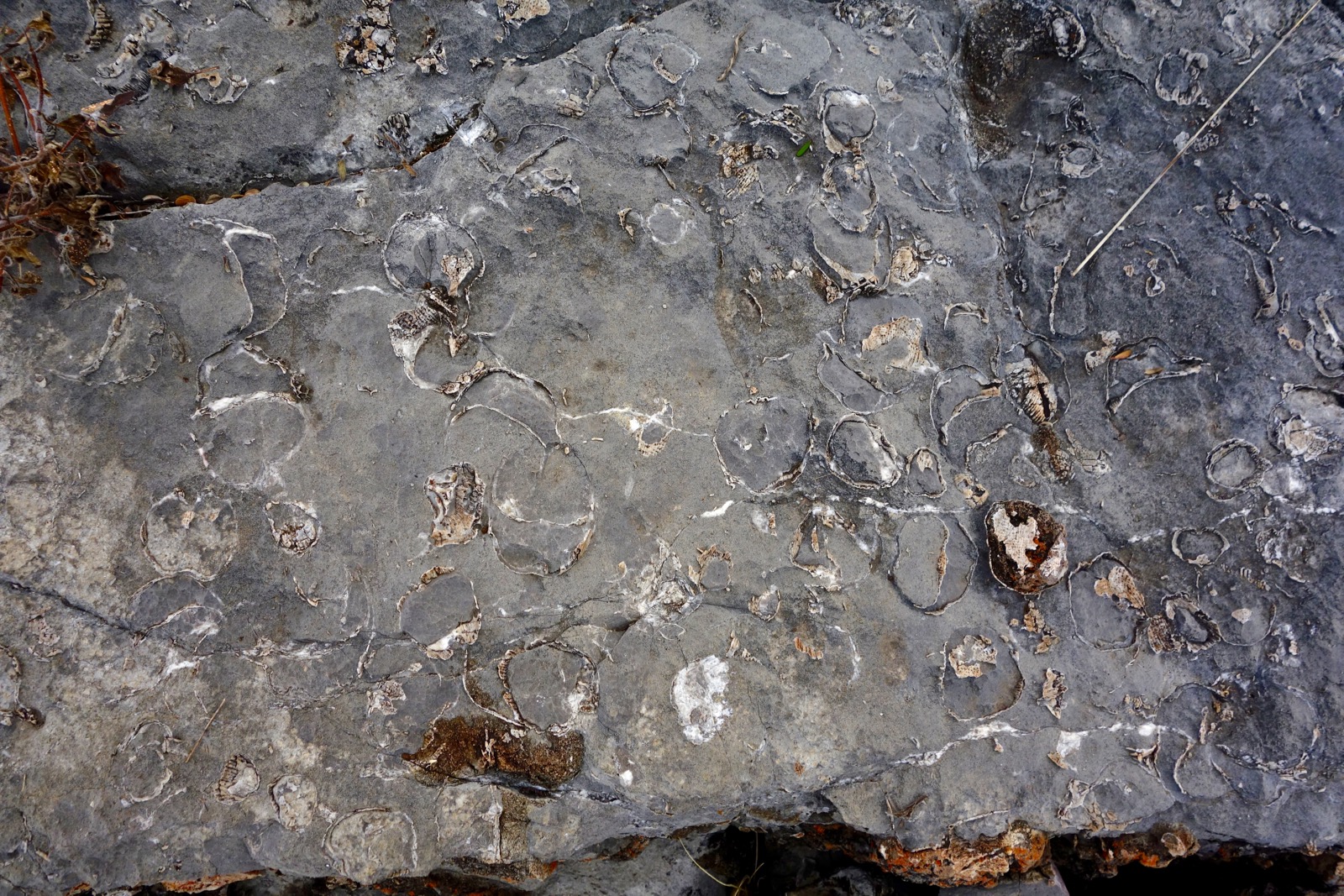
On the south side of Apache the limestone is thickly decorated with fossilized nodules and worms, lending a fascinating texture. Just before the 7,460 foot saddle is a cristate cane cholla, a first for us. It is a true anomaly.

Pass through "French Joe Park," which features an ancient symmetrical alligator juniper. The abundance of fossils continues.
Your reward is a class 2+ scramble up the limestone summit block.

Crest French Joe Peak, 7,675 feet, at 3.1 miles. We might have considered hiking to Granite Peak, right of image-center, to see more of the Whetstones but continuing on from here looked undesirable, if not impossible.

This image looks from French Joe to Apache. On our return we contoured around the west side of the peak at 7,600 feet and intercepted our upcoming track.

Birds in Las Cienegas
My friend the geologist is also a serious birder. While we were driving through Las Cienegas National Conservation Area at the end of November, he identified the following birds: northern harrier hawk, meadowlark, loggerhead shrike, Cooper's hawk, canyon towhee, Mexican jay, and blue-gray gnatcatcher.
I'd like to thank John Bregar, geologist, ornithologist, and naturalist, for bringing to light and identifying the natural treasures of Apache Peak.
4WD, HC Road from Hwy 83 to Apache Peak Parking
Click to enlarge image.

4 comments:
I have been to the top of Cottonwood Peak and I want to hike Apache Peak but it is hard to find hikers in nobody does nothing but sports Benson, AZ Did you find any caves large or small. I've only found shallow caves but I plan to join the Cochise County Cavers since they respect the caves and probably know where they are. The Cottonwood trail is tricky since the Forest Service has not maintained it for a long time
I do not recall any caves on the Apache Peak hike, but it is a difficult area where all sorts of things might be hiding. Debra
I hiked Apache Peak yesterday with three others and a dog. We did not see any caves or mine tailings.
Dogmaah How did you get to Apache Peak? Did you drive in the way stated above and hike to the peak from there? Was your experience similar to this blogpost from 2017 or has there been terrain changes?
Post a Comment