Essence: Until 2017, Mount Glenn had a strong reputation for repelling hikers with heavy brush. The landscape opened considerably after the Lizard Fire. Nevertheless, the hike is more difficult than statistics imply. Slopes are steep and grasses hide rocks that roll underfoot. Tour seven knobs on the ridgecrest while climbing to the highpoint of the sky island. The prominence northwest of the Dragoon Benchmark is a few feet higher and holds the peak register. View the ranges of Southeast Arizona and look into Cochise Stronghold throughout the trek. This hike is within the Coronado National Forest but private inholdings are nearby so remain on route.
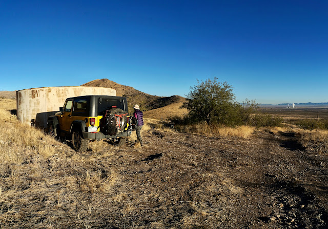
Travel: East of Benson, take Exit 318 from Interstate 10 at Dragoon Road and measure distance from the stop sign at the bottom of the eastbound exit. (Your odometer will likely vary.) Drive south on Dragoon Road, passing the town of Dragoon at three miles. At 13.0 miles, turn south on US 191 toward Sunsites. Turn west on Ironwood Road at 19.5 miles. There is a sign for Cochise Stronghold before the intersection. You'll be driving toward Mount Glenn and Rockfellow Dome. Cross a cattle guard at 24.8 miles where pavement ends. Turn right onto FSR 795, a good gravel road, at 26.3 miles. Enter the Coronado National Forest at 26.9 miles. Turn left onto FSR 4378 at 27.7 miles. If you are in a 2WD vehicle, park at this junction. The last 0.7 mile is maintained but rough and 4WD with good clearance is recommended. Park at the round water tank on the right at 28.4 miles. There is another pullout on the left at a stone foundation 0.15 mile further up the road but parking there inhibits your options. The road is technical beyond that.
Distance and Elevation Gain: 5.3 miles; 2,800 feet of climbingTotal Time: 5:00 to 7:00
Difficulty: Primarily off-trail; navigation moderate; Class 2+; no exposure
Map: Cochise Stronghold, AZ 7.5' USGS QuadDate Hiked: December 6, 2020
History: The Dragoon Mountains are imbued with history; follow in the footsteps of Cochise. His friend Tom Jeffords paid this tribute. "Cochise can't even read a map, but he and his men know every gulley, every foot of every mountain, every waterhole in Arizona. His horses can go twice as far as yours in a day, and his men can run on foot as far as a horse can run. He can't write his name, but his intelligence service knows when you got to Fort Grant and how many men you got. He stopped the Butterfield Stage from running. He stopped the U.S. Mail from going through. And for the first time in Indian history, he has all the Apaches from all the tribes fighting under one command."
Quote: You must speak straight so that your words may go as sunlight into our hearts.
Cochise, Chiricahua Chief 1805-1874
The entrancing geology of the Dragoon Mountains is revealed from Ironwood Road. To the south are the weathered granitics for which Cochise Stronghold is renown. The eastward climbing ridge of Mount Glenn (image-right) is composed of limestone and quartzite.
The Apache Generating Station in Cochise is visible from the water tank, elevation 5,060 feet. The plant is converting from coal to natural gas while diversifying its energy portfolio. The station generates 20 megawatts of renewable energy at Apache Solar Project. (Thomas Holt Ward, photo)
The first objective is to achieve the east ridge of Glenn. There are two possibilities, both somewhat arduous. Judging from trip reports, the more common route takes the road to the mine and then ascends south to the ridge. I'll describe that route first but if I had it to do over, I'd ascend on our return route.
The lower slopes of the Dragoon sky island are Desert Grasslands within the Sonoran Desert. Saguaro are absent but alive within the expanse of golden grasses are sotol, agave, prickly pear, beargrass, oak, and mesquite.
Walk southwest up the road on baby heads and boulders while putting away elevation with ease. Stay straight at the 0.2 mile split. After the first switchback the Lizard Fire burn scar is evident. Lightning ignited the conflagration in June, 2017, burning 15,000 acres. The track ends at a mine at 5,480 feet, 0.75 mile. The adit goes back a fair distance. You'd need a headlamp to venture inside. This is not recommended by this blog! (THW, photo)
From here, the route is off-trail with no guiding cairns. The ridge is 300 vertical feet to the south. Start right at the mine or back up until you find a workable opening. It looks more foreboding than it is. Pick the path of least resistance and plow up the ultra steep slope. It is brushy but not too prickly. Footing is good on a mix of dirt and limestone. Climbing the pitched beast in the morning inspired experimentation on the descent. Principally, we intended to find a route that stayed off the treed north aspect.
It took almost an hour to put the first mile away. We contacted the heart-soaring east ridge at 5,820 feet. Oh! to be an eagle and effortlessly span the open sky from the Dragoons over the Wilcox Playa to the Dos Cabezas Mountains. (THW, photo)
The peak is not yet visible but the way is clear and obstacles are few. Walk on broken quartzsite, limestone, and occasional bedrock. This hike is for the sure footed. Unstable rock is disguised by thick mats of grass. The ridgeline walk requires both patience and concentration. Ascend west to Point 6,241', shown, and then northwest to Point 6,740', image-right. (THW, photo)
Along the way are a few seemingly old and very large cairns. As guides, they are superfluous and yet they do their job with a certain earnestness. There are hints, fragments, of game and possibly human trails.
The fire opened the visual field--look over to the igneous formations in the Stronghold. If brush was an issue on the lower ridge, the way is now clear. Burned foliage is recovering amongst unharmed survivors such as symmetrical agave and ocotillo. Shindagger is notably absent.
Progressing up the ridge, Mount Glenn comes into view, image-left. At Point 6,740', 1.8 miles (image-right), the climbing ridge turns southwest and makes for the summit. A rock barrier stretches horizontally across the ridgetop above the saddle with Point 6,841'.
My partner climbed to the top of the wall but the downclimb was dicey. So we scooted a few paces south and easily clambered over the barrier. The structure is composed of stacked boulders in light and dark shades highlighted with patches of yellow lichen. (THW, photo)
The incline to Point 6,841' is steep but short. Step up on bedrock boulders and small terraces.
The damage from the Lizard Fire is concentrated in a burned forest 400 feet off the summit. The understory is reviving but the trees are skeletons. Pre-fire trip reports claim this area was almost impenetrable and visually constricting. The image below also depicts the ridgeline rock outcrop. (THW, photo)
The outcrop is 200 feet below the summit. Either climb directly up the spine through the line of boulders or skirt them on the south. We climbed the outcrop while ascending and flanked it on the descent which worked well. Plants play interference with the scramble but it was playful. Pass swirled and folded stone. (THW, photo)
Transect the linear summit ridge right at the Dragoon Benchmark, 2.8 miles. While the disk is inexplicably blank, the reference marker reads, "Dragoon, 1935." A solar cell is pinned to the ground but the device it powered has gone missing from the stacked peak cairn. (THW, photo)
You'd have to wing your way 27 miles to Reiley Peak in the Winchester Mountains to encounter a taller summit. (Glenn has a rise of 2,899 feet.) So, of course, the views are outstanding. In the Coronado Forest alone (!) spin around to see the Huachuca, Santa Rita, Whetstone, Rincon, Santa Catalina, Galiuro, Pinaleño, Dos Cabezas, and Chiricahua mountain ranges. Below, Stronghold Canyon West flushes the Dragoons to its master river, the San Pedro. The views into the crazy mash of jumbled rocks in the Stronghold are wonderful but I'd rather just go walking amongst those extraordinary stones.
The image below was shot from the benchmark looking northwest to the sister prominence 0.1 mile away. It is the consensus that the northwest summit is three to four feet superior. That's where the peak register was located in 2020. Even accounting for people who don't sign registers or failed to locate this one, not many people visit this mountain. The most recent entry was one and a half years prior to ours.
As noted earlier, we walked a few feet south of the benchmark to a small dip in the ridge and began our descent from there. The downclimb is pitched and loose with rocks at the angle of repose. It's not a panacea but it is faster than the ridgeline scramble. Dive down staying close to the cliffs and at first opportunity, crank back sharply to the northeast ridge.
It would be all too easy to get sucked into this tempting east-facing swale.
The descent is its own expedition. We'd forgotten how many knobs we climbed. And yet, it had been awhile since I felt that serene. It was as quiet as quiet gets. The air was untroubled; we hiked in solitude. The thin, but warm-enough December sun cast long shadows.
At 5,800 feet, we blew by our upcoming route from the mine and stayed on the east ridge. It presents much like the former stretch.
At 5,640 feet, the ridge splits very subtly. Veer onto the rounded northeast ridge. You will get a visual of the water tank from here, if not before. The slope is free of inhibiting brush and is satisfying from a ridge purest point of view. We saved 0.4 mile and over half an hour compared with our ascent route. This image of the line of descent was shot from the water tank. (THW, photo)
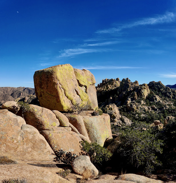
I am partial to the spheroidal granite in the Cochise Stronghold. This image was taken on an exploratory hike in the Stronghold in January, 2014. (THW, photo)


