Essence: Lower White Canyon has a slim channel, high walls, and a deeply fluted, silky sandstone floor. Utah-blue sky contrasts with vibrantly hued stone. Visitation is concentrated upstream of this quiet stretch at Natural Bridges National Monument and the Black Hole of White Canyon. This hike is short and handy enough to be treated as an interlude for those passing through on a road trip.
Travel: The turnoff from UT 95 is one mile east of the bridge across White Canyon at MM 54.5. A brown sign reads, White Canyon Access. This road is not to be confused with Farley Canyon or Lake Powell Access at MM 53. The dirt road grows increasingly rough as you drive south. Good clearance is necessary to negotiate lumpy bedrock. Park at 1.7 miles on the east side of the track on sandstone. Check to see that two washes head west on the opposite side of the road. This parking place leads to the first non-technical drop into the canyon south of UT 95.
Distance and Elevation Gain: about 6 miles; 400 feet of climbingTotal Time: 3:00 to 4:00
Difficulty: Off-trail; navigation moderate; One Class 3 move with no exposure; flash flood hazard--do not enter if storms threaten in the Cedar Mesa region; be prepared to wade.
Map: Copper Point, UT 7.5' USGS Quad
Date Hiked: April 21, 2021
Poem:
It’s not often that water flows over rock in the desert
But when it does, it is woman flowing over man
Very slowly she transforms him
He becomes deeper, more open, and softer
Meanwhile, he’s carrying her!
On a sinuous, direct path toward her completion
If you listen while the water and rock make love
You will hear them both laughing.
Debra Van Winegarden

Route: Head west down a shallow wash to the White Canyon rim. Walk a few paces north to a slickrock slope descending to the canyon floor. Hike generally northeast upcanyon to the UT 95 bridge (no exit!) and return as you came.


Some of us will travel great distances on foot to witness the sculpting power of water. Extraordinary fluted sandstone is prevalent in Lower White Canyon. (Thomas Holt Ward, photo)

Route: Head west down a shallow wash to the White Canyon rim. Walk a few paces north to a slickrock slope descending to the canyon floor. Hike generally northeast upcanyon to the UT 95 bridge (no exit!) and return as you came.

From the parking area on a small stone flat, elevation 3,860 feet, look across the road and locate two washes flowing west. The artery on the left/south is slightly more accommodating.

Both tributaries flush onto a broad platform shortly before the canyon rim. The photo below was shot looking back to the east. White Canyon is carved through buff-colored Cedar Mesa Sandstone. The sand accumulated along the shores of an ancient sea about 270 million years ago during the Permian epoch. The fine-grain, silky texture of the stone today indicates the formation was created by wind-blown dunes rather than granular sands washed along the coast by tides and currents. Cedar Mesa Sandstone is older than the Navajo Sandstone so prevalent on the Colorado Plateau.
White Canyon flows through a broad flat valley as it bears down on the Colorado River. The 400-foot-tall brilliant red-brown cliff band framing the valley is Organ Rock Shale. Composed of sandstone and siltstone, it overlies Cedar Mesa Sandstone, and is thus younger. Both strata are sub-units of the Cutler Formation.

Stand on the rim of the shallow canyon at 0.35 mile. High water on Lake Powell once inundated White Canyon's confluence with the Colorado River (about seven miles downcanyon) and came to within a third of a mile of this point. On April 21, 2021, lake level was elevation 3,563 feet, allowing for a free-flowing convergence. (THW, photo)

To access the canyon floor, drop a few feet down to the next level and walk about 30 yards to the north. Descend the sandstone slope, shown. As friction pitches go, this one is gentle.

Contact the canyon floor at 0.4 mile. My GPS unit gets wonky in tight canyons so I won't be able to give mileages to specific features on the way to or from the bridge. The slope you came in on is your ticket out of the canyon so if you need to, mark this location with a cairn. Of note, there are other opportunities to exit the canyon downstream. However, there is no escape option upcanyon until you are well north of the bridge.

All the elements at play in a fluid canyon are presented over the next two and a half miles. Soft sand on the wash bottom transitions to cobbles and then bedrock. Though the walls are widely spaced to begin and only about 40 feet in height, their vertical nature immediately constrains the horizontal vision field. We poked around in feeder slots but never got very far given the prevalence of swirling potholes. (THW, photo)

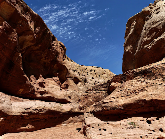
Within half a mile, the corridor constricts to about 12 feet, pinches through a short slot, and widens in a jumble of beautiful water-polished boulders. The Southwest is suffering from a prolonged drought so the only water we encountered was in deep tanks. This hike would be an entirely different proposition with flowing water. White Canyon begins on the southern slopes of Bears Ears and joins forces with Burch Canyon in Natural Bridges. Some decades ago I was hiking upstream of the Monument in heavy rain when White Canyon Creek, in a matter of minutes, went from ankle to thigh deep. Flashing is a very real hazard on this hike. Below, white sky dots sync with dark solution cavities. (THW, photo)

Vertical, storm-carved walls climb to 250 feet. Desert varnish streaks in tiger stripes. Varnished waves on the floor look razor-sharp but it is an optical illusion. The wave edges are smooth and barely perceptible. (THW, photo)

A jammed and vertically suspended cottonwood log signals the beginning of a brief cluster of massive boulders. We found a way through upcanyon-right. There is one Class 3 move with silky holds. Some people will appreciate a boost or hand-up. Do not let this stop you--the sculpted stone gallery lies just ahead.

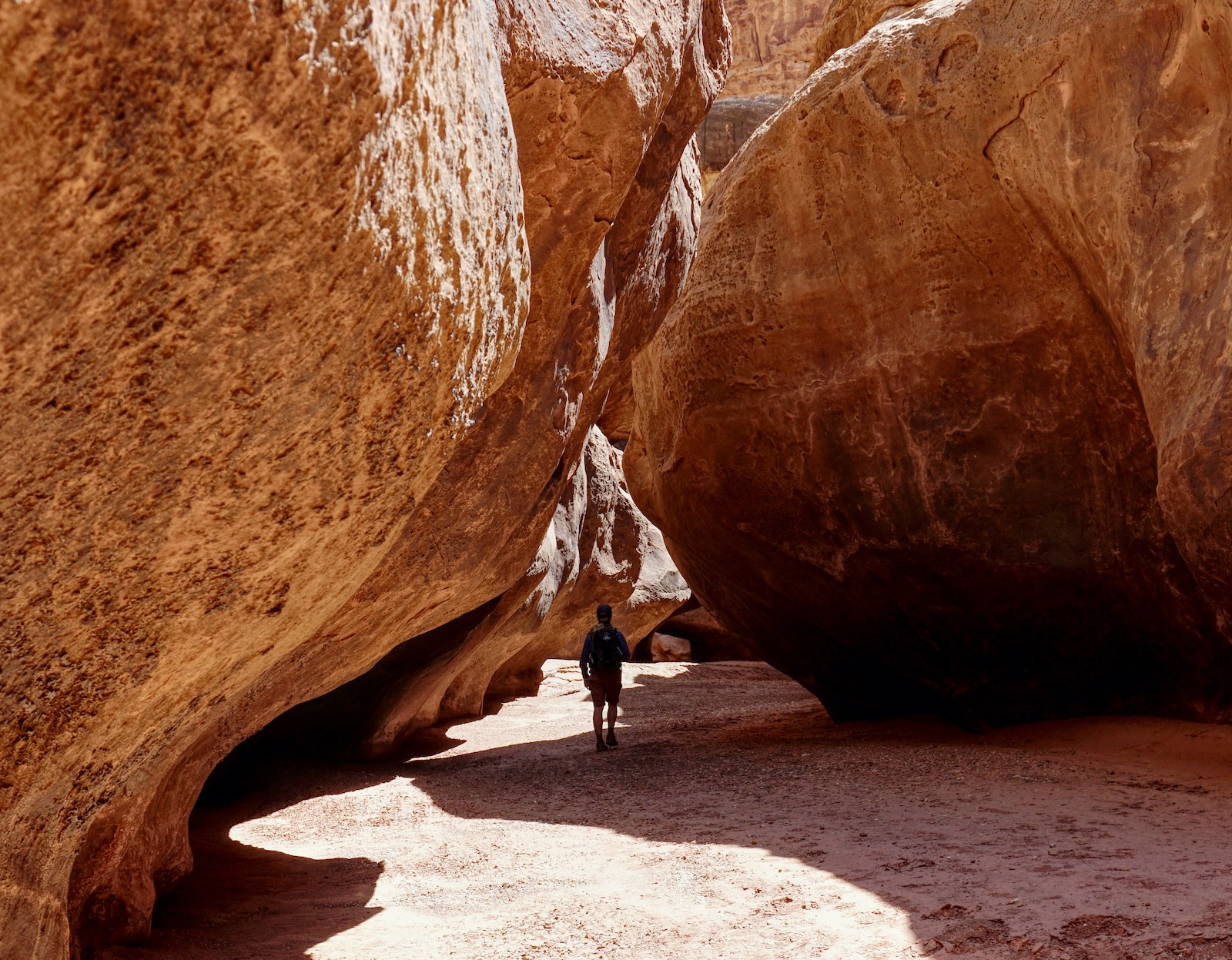
Beyond the boulders, bypass a linear tank upcanyon-left. This photo looks back on the bypass, image-right. At the upper end of the go-around is a long stream of fluted forms incised on the sandstone floor. In forty years of traipsing around in the desert Southwest, I've never seen anything approaching this artistry. Geologists will tell you the intricate carvings are made by suspended grit and boulders bouncing along in flash floods. The ever-evolving sculpture leaves me speechless. (THW, photo)

Scamper through a second set of boulders and enter an altogether different and sublime canyon segment. Here the floor is perfectly flat with bulging sidewalls pressing toward one another. (THW, photo)
A suspended horizontal log pinned between canyon walls casts a shaft of shadow. It mimics and signifies the rapidly approaching highway bridge.

After about three miles of blissing out in White Canyon reverie, you will be standing under the bridge spanning the walls on Utah State Route 95, the Bicentennial Highway. The road between Blanding and Hanksville existed as a primitive dirt road in the 1930s. The highway was improved and paved in time for the U.S. Bicentennial in 1976. (THW, photo)

We did this hike in the middle of a long day of driving. You may continue upcanyon before turning around. Do your research first if you intend to pass through the Black Hole. (THW, photo)

A few blooming plants applied dots of color, including yellow evening primrose...

...and Sclerocactus parviflorus. (THW, photos)

Thank you, Road Trip Ryan for instructions to the parking patch and for turning us on to White Canyon below the bridge. We'd driven over the span hundreds of times totally oblivious of the hidden wonders below.
No comments:
Post a Comment