Essence: Majestic Miller Peak and its companion Carr Peak reside opposite one another on the Miller Canyon rim. This hike ascends both mountains and spans their common ridge. There are multiple approaches to Miller Peak, the undisputed highpoint of the Huachuca Mountains. This description begins on the Carr Peak Trail and transitions to the Crest Trail, accessing Miller from the north. Given the total domination of Miller, the vast visual sweep of flowing grasses in the upper basin, three diverse rock formations, unparalleled vistas, and the sensuous forested folds of the range, this landscape serves nicely as the definition of beautiful. The Huachuca Mountains are a handful of miles from the U.S.-Mexico border. The range is managed by three jurisdictions: Department of Defense (Fort Huachuca), National Park Service (Coronado National Memorial), and U.S. Forest Service (Coronado National Forest and the 20,190-acre Miller Peak Wilderness where this hike is located).
Travel: From I-10 in Benson, drive south on SR 90. In Sierra Vista, segue to Buffalo Soldier Trail and turn right on SR 92. Just south of Mile Marker 328, turn west on Carr Canyon Road and measure distance from the junction. At 1.3 miles pavement ends. Pass through an open gate at 1.4 miles and enter Coronado National Forest. There are two caution signs: smuggling and illegal immigration may be encountered, and vehicles over 20 feet are prohibited. 4WD with low range and sturdy tires is recommended. The road is graded but becomes increasingly rubbly. It climbs aggressively--a whopping 2,740 feet over seven miles. Two lanes narrow to one with turnouts. There are ten switchbacks that become increasingly tighter as you climb. This road is not for people with a fear of heights. The narrow shelf is considerably exposed. At 6.2 miles the Reef Townsite Campground is on the right and Old Sawmill Spring Trail is on the left. The road improves. The large Carr Peak trailhead parking lot is at 7.4 miles. Ramsey
Vista Campground begins at the far end of the lot.
Camping: Both of the U.S. Forest Service campgrounds have spacious, private, wooded sites with fire pits and grills, picnic tables, pit toilets, trash cans, and tent pads--but no water. Fees apply. First come, first served. Ramsey Vista has eight sites and Reef Townsite has 16. There is an option to walk from Reef Townsite on the Old Sawmill Spring Trail and intersect the Carr Peak Trail. In December, we were the only visitors at either campground.
Distance and Elevation Gain: 12.4 miles; 3,350 feet
Total Time: 6:00 to 8:00
Difficulty: Trail; navigation easy (four trails, signed junctions); Class 2; no exposure; carry all the water you will need. Huachuca is a Pima word that translates, "place of thunder." Let this be your summer monsoon warning--be off the peaks by noon. The Carr Peak Trail is cut into steep slopes--avoid when snow covered. Spring and fall are optimal.
Quote: The heart from the moment of its first beat instinctively longs for the beautiful. Richard Jefferies.
Difficulty: Trail; navigation easy (four trails, signed junctions); Class 2; no exposure; carry all the water you will need. Huachuca is a Pima word that translates, "place of thunder." Let this be your summer monsoon warning--be off the peaks by noon. The Carr Peak Trail is cut into steep slopes--avoid when snow covered. Spring and fall are optimal.
Map: Miller Peak, AZ 7.5' USGS Quad
Date Hiked: December 7, 2021Quote: The heart from the moment of its first beat instinctively longs for the beautiful. Richard Jefferies.
Miller Peak is one of five mountains in Arizona with over 5,000 feet of prominence. Coupling the summits of Miller and Carr is a reasonable one-day quest for most hikers thanks to well-engineered and maintained trails.

Route: Bear south on the Carr Peak Trail. It swings west along the southern slopes of Carr. Take the Carr Peak Spur to the summit either coming or going. Circle Miller Canyon basin and intersect the Crest Trail heading south. The Miller Peak Trail climbs to the highpoint of the range. Return as you came. Note: The Miller Peak topographical map has 25-foot contour intervals.

Carr Peak Trail
The trailhead is located on the west side of the parking lot, elevation 7,375 feet. Posted, no bikes in the Miller Peak Wilderness. Ascend gradually through a mix of manzanita, madrone, alligator juniper, and ponderosa in the upper reaches of the Madrean pine-oak woodland. Cross the wilderness boundary at 0.1 mile on an interior ridgetop. A connector trail from the north end of the Ramsey Vista Campground joins here. This is one of many softly rounded, north-bearing ridges in the upper Carr Canyon basin. Look over the manzanita tunnel to the north slopes of Carr Peak. In December, aspen and oak have shed their leaves and the mountain is cloaked in gray. The Huachuca Mountains support 19 rare plant species and 26 avian species of conservation concern. In December, blossoms were absent and so were the birds.

We walked straight into the winter sun, low in its southernmost realm. Trees part to reveal grand views of Sierra Vista already 3,000 feet below. Ranges to the east ripple off one after another in variegated hues of blue.
(Thomas Holt Ward, photo)

The lower part of the trail is rubbly. Chipped rock mitigates trenching of the old treadway which plows through limestone boulders. At half a mile, enter an extraordinary, elegant and well organized Apache pine forest. Limbed, straight-up trunks culminate in crowns with long needles in bundles of three. These attractive trees can grow to 120 feet.
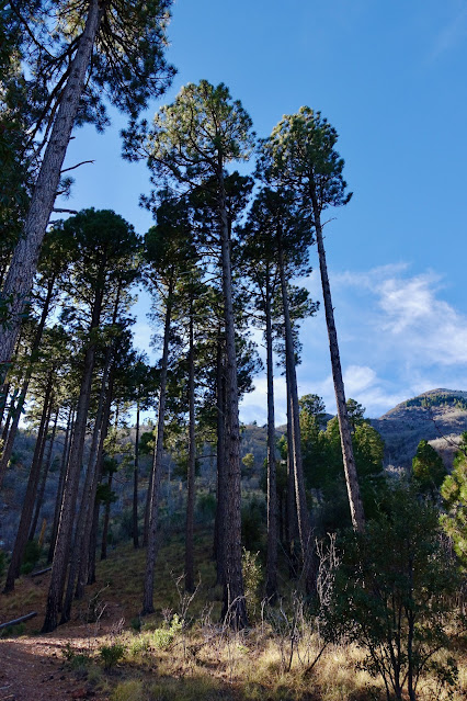
At 0.65 mile, the Old Sawmill Spring Trail comes in from the Reef Townsite Campground. This is the first of many very old and charming trail signs.

Soon after, a series of ten switchbacks mount up the far eastern rim of Carr Canyon basin. Limestone sheets are uplifted naturally at an angle and subsequently were blown out to make passage. Watch for a limestone sinkhole to the right of the trail. Gain the northeast ridge of Carr Peak at 1.3 miles, 8,100 feet. From here, the road to Reef Mine and the platform's east-facing escarpment are visible. (THW, photo)

Four significant fires have rolled across the Huachuca Mountains since 1977. The most recent, the Monument Fire in 2011, began on the U.S.-Mexico border, burning south into Mexico and then turning north and scorching 38,000 acres in the Huachucas as far north as Carr Canyon. The fire was at its highest intensity in the Carr Peak area, wiping out vast tracks of conifer, including this grassy ridgetop. (THW, photo)

The trail is a constantly evolving overlook in and of itself. Miller Peak makes its first appearance at 1.5 miles. At ground level, we were fortunate to spot a ptarmigan brood dressed in earth-colored camouflage. The footpath soon slides off to the north side of the ridge and doesn't regain it for over 600 vertical feet. Post fire, an opportunistic, young aspen forest has taken the place of Douglas fir. Northwest are the remarkable limestone ramparts of Ramsey Peak.

The trail returns to the northeast ridge at 8,750 feet and begins contouring below Carr on the south side. The pathway is cleaved into a steep slope that crashes down the east wall of the range. Above are exfoliating limestone cliffs. Freshly broken boulders were scattered on the trail. Some places on the planet flash red when you pass--don't linger.

Round the corner and see the rim of the Miller Canyon bowl encompassing the two peaks. In December, the tapestry of color was vivid. Grasses were burnt gold. The Apache pine, brilliant green. The rock formation had transitioned from gray limestone to a deep purple rhyolite. (THW, photo)

The Carr Peak Spur takes off at 2.5 miles, 9,000 feet. We saved the short jaunt up Carr for our return trip, described later in this post. The image below was taken from the spur. The route to Miller from here sweeps west, south, and finally, east. Over the next mile the trail gives up 450 feet.

The Monument Fire incinerated the south-facing slope leaving an open, park-like environment with milk-white quartz blocks and an abundance of perfectly symmetrical agave.

Crest Trail
The Carr Peak Trail ends at the junction with the Crest Trail at 3.6 miles. The Crest Trail comes in from the west and continues south past the Miller Peak spur to its end at Montezuma Pass. The 790-mile Arizona Trail tracks along with the Crest Trail in the Huachucas before transitioning to the Yaqui Ridge Trail. The southern terminus of the AZT is less than ten miles from here. For Miller, turn left on the Crest Trail and descend another 150 feet. We were so dubious about the elevation loss that we climbed back up to double check. Trust the sign and disconcerting drop.

The trail bottoms out at the junction with the Miller Canyon Trail, 8,550 feet. It's anyone's guess how a bathtub got hefted to the trailside spring. The Forest Service recommends purifying the water.

The contouring Crest Trail takes direct aim at Miller Peak. Look deep into Miller Canyon and to SR 92 crossing the San Pedro River valley heading toward the Mule Mountains and Bisbee.

Pass through the Miller-Carr saddle at 4.3 miles, approximately 8,540 feet. The trail tracks along the east side of the ridge. We saw almost no wildlife but between our coming and going a bear happened along pawing rocks to scrounge for grub. Aspen were taking hold post-fire and the rock formation transitioned to an intrusive igneous diorite granitic. The north face of Miller features weather-scoured and eroded stone.

We tripped a surveillance camera in the forest as we approached the west ridge of Miller. Soon after, we got repeatedly buzzed and inspected by a Border Patrol helicopter. Trip reports warn of running into immigrants on the Crest Trail. We saw no evidence of this in 2021. However, hiking solo is not recommended. Arrive on the west ridge at 9,000 feet. (THW, photo)

Miller Peak Trail
The Miller Peak Trail leaves the Crest Trail at 5.4 miles, 9,100 feet.

The spur switchbacks moderately steeply through boulders on the north side of the ridge before returning to the center line for the finish.

Arrive on the broad summit at 5.9 miles. With a rise of 5,011 feet, this is one of the supreme vantage points in Southern Arizona. Only the foundation of an historic fire lookout tower remains. All I could find was a 1962 reference in the Tucson Daily Citizen: "The Miller Peak Lookout in the Huachuca Mountains will be flown by
helicopter to the top of the mountain whose upper elevations still are
covered by deep snow."
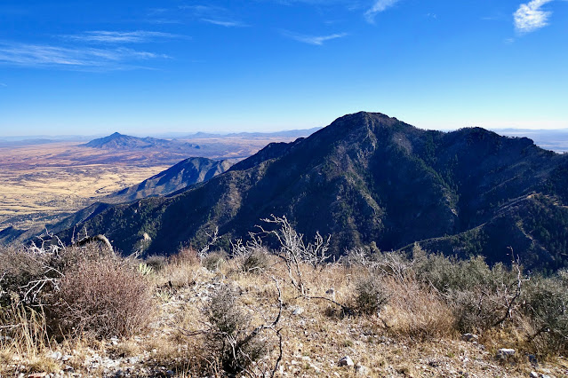
The great circle of the horizon is spellbinding by sheer immensity. In the south, Sierra San Jose is the conical peak beyond the arrow-straight border wall. Vanishing into the blue distance are the vast and mysterious reaches of Mexico. (THW, photo)

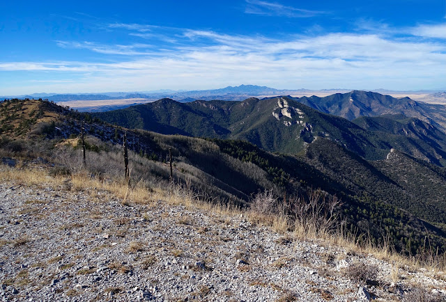
Directly below to the south (and out of sight) is the Lutz Canyon Trail, yet another access option for Miller. Bob Thompson Peak is image-left and Montezuma Peak is image-center. The Coronado National Memorial is south of their shared ridge. Coronado Peak, within the monument, is southwest of Montezuma Peak.

Well to the west is monolithic Baboquivari Peak. Northwest, Mount Wrightson has earned its supremacy in the Santa Rita Mountains. In the foreground are the Crest and Carr Peak trails circling high in Miller Canyon.

To the north, the Whetstone Mountains lie west of SR 90. The Border Patrol surveillance blimp is on the ground because of high winds. Finally, Carr Peak our next quest, is on the left.

Retrace your steps to the Carr Peak Trail. This image was shot as it swings back east above Miller Canyon. Carr Peak is over on the right.
Carr Peak Spur
From the Carr Peak Spur at 9.3 miles, the summit is only 0.3 miles afar with 237 feet of elevation gain. The out and back takes about half an hour, including time on top.

This trail affords one of the biggest views of the Miller Canyon headwall. Wend through boulder gardens, first rhyolite and then limestone.

The gravely domed summit is a superb observation point with a rise of 700 feet. If you are short on time, Carr would be a wondrous journey all by itself. Huachuca Peak is to the right of unmistakable Ramsey Peak.
Miller Peak is only 229 feet higher than Carr.
Sharply down to the north is vertical-walled Carr Canyon. On the broad, treed flat a white vehicle is parked at the trailhead. You can make out the trail on the initial ridge and the elegant forest, image-right. The land plunges abruptly to the valley floor. Return on the now familiar treadway back to the trailhead.

Personal Note: I'd like to offer a brief comment on the Covid-19 pandemic that has ravaged humanity for two years running. I am so sorry for those of you who have suffered physically, emotionally, or economically during this pandemic. Or worse, lost a loved one. Thirty years ago I put Miller Peak on my master wish list. Life takes inexplicable turns and my quest was delayed time and again. Ironically, this opportunity arrived while I was still in the midst of a case of breakthrough long-haul Covid. Therefore, my relatively slow hike was imbued with profound gratitude and heightened awareness for the beauty of the natural world, and Miller Peak in particular.
No comments:
Post a Comment