Essence: Explore the rugged and wild divide running northeast to southwest
between Wild Burro and Ruelas canyons in the "Little Turtle Dove Mountains." Climb two ranked summits and one
spiky point. The off-trail segment is brushy and contending with boulders slows progress. And yet, the granite spheroidals are a compelling feature of the hike. Evolving views from the peaks and the ridge between them are entrancing. Tortolita Mountain Park is known for its density of crested saguaros and vast network of trails admirably engineered and maintained by the city of Marana. Spend a peaceful day in the lush Sonoran adjacent to Tucson. The trek is suitable for hikers experienced with off-trail desert travel.
Travel: The hike begins from the Wild Burro Trailhead, 14810 N. Secret Springs Drive. Measure distance from Twin Peaks and Tangerine roads. Twin Peaks becomes Dove Mountain Blvd at the intersection. Go north on Dove Mountain. The Peak 4,373' divide is visible from the road. At the traffic circle at 4.5 miles, take the first right, staying on Dove Mountain. At the Ritz Carlton gatehouse, tell the attendant you will be hiking. In another 0.7 mile, turn right and then immediately go right again into the large dirt parking lot. Restroom and drinking faucet, no fees. Maps are available at the trailhead.
Distance and Elevation Gain: 7.6 miles; 2,200 feet
Total Time: 5:30 to 7:00
Difficulty: Trail, off-trail; navigation moderate; Class 2+ with no exposure; brushy--catclaw and yucca unavoidable--dress defensively. Carry all the water you will need and hike on a cool day.
Map: Ruelas Canyon, AZ 7.5' USGS Quad
Date Hiked: January 17, 2023
Quote: The finest workers in stone are not copper or steel tools, but the gentle touches of air and water working at their leisure with a liberal allowance of time. Henry David Thoreau
The finest workers in
stone are not copper or steel tools, but the gentle touches of air and
water working at their leisure with a liberal allowance of time. Share
this Quote
Henry David Thoreau
Read more at https://www.brainyquote.com/topics/stone-quotes
Read more at https://www.brainyquote.com/topics/stone-quotes
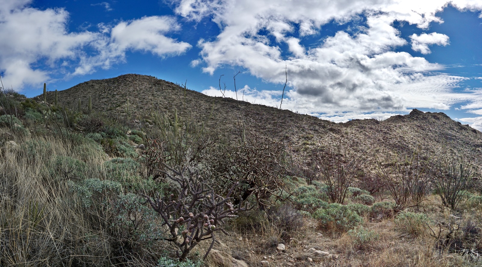
The Peak 4,373' divide is detailed from the Wild Mustang Trail. Peak 4,373' (image-left), unofficially known as Ridge Crest Peak, is climbed occasionally. Neglected Point 4,070' and Peak 4,053' have enthralling features. The commanding peaks in the Santa Catalina Mountains soar east of Oro Valley. (Thomas Holt Ward, photo)

Route: Hike northeast on the Wild Burro Trail (WBT) to the Alamo
Springs Spur Trail (ASST). Turn east and link with the Alamo Springs Trail (AST), bearing southeast. Crest a small southwest-running ridge. Leave the AST and climb roughly east to Peak 4,373'.
Follow the ridge southwest over Point 4,070' and climb Peak 4,053'. Return
to Saddle 3,710'. Descend northwest to the AST and hike southwest back to the WBT. Unutilized segments of the AST are indicated with a blue line. The Ruelas Canyon quad has 20-foot contour intervals.

Peak 4,373', Ridge Crest Peak
The trailhead for the Wild Burro Trail is on the south side of the parking lot adjacent to the restroom, elevation 2,800 feet. This route stays on the WBT for two miles. You can't get lost--signs are color coded and plentiful. (THW, photo)

The WBT heads east for 0.15 mile and then turns northeast. (The south spur is a link to Dove Mountain Blvd.) Crisscross
back and forth across the wash on the trail or, just
walk up the waterway. The Wild Burro Canyon floor is broad, flat, and uniform. On our hike the atmosphere was unusual. We waited for a three-day storm to blow out and began hiking mid-morning. Visibility went well into forever, rock glistened, droplets clung to flora, sand underfoot was firm (no mud!), and the earth smelled bright and fresh.
The Tortolitas are prized for wildflowers but nothing was blooming in January. We gave our full attention to the remarkable array of mature cholla: staghorn and buckhorn, walking stick, silver, teddybear, and robust stands of chainfruit. Living within chollaland are elder saguaro, paloverde, barrel cactus, creosote, brittlebush, and acacia.
Equally captivating were spheroidal boulders piled up on either side of the wash forming ridges and peaks. The Tortolita Mountains were birthed in the Crystalline Basement. The range is a northwestern extension of the Catalina Metamorphic Core Complex
which makes up the Santa Catalina Mountains. The 600-million-year-old igneous Tortolita Mountains Granite emerged from beneath the crust of the earth by tectonic forces roughly 18 million years ago. Over the eons weathering processes smoothed the edges and corners to create the spheroids. (THW, photo)

Trails
converge at a signed junction at 0.7 mile. This hike is a stem and clockwise
loop beginning on the WBT and ending
on the AST. However, you could start on the AST and hike counterclockwise. This is particularly attractive if your one goal is
Peak 4,053'. For the purposes of this description, turn left, staying on WBT. In another tenth of a mile, the Upper Javelina Trail branches.
The WBT transitions to a more pleasant singletrack composed of crushed granite.
At 1.9 miles the WBT leaves the wash. Follow the sign leading to the Alamo Springs Spur Trail. The canyon narrows, walls steepen, and water-scoured boulders reside in the channel.

At 2.0 miles, 3,040 feet, the ASST hooks a right and climbs out of the drainage. Boulders are heaped up on either side of the trail. The engineering marvel maintains a pleasant grade with steps made from scavenged stone or cut into bedrock bedazzled with quartz veins. The path tracks along a tributary of Wild Burro while steadily wandering up the hillside. Soaking wet, brilliant green moss contrasted with black stone.

The link trail runs into the AST (and ends) at a switchback at 2.5 miles, 3,400 feet. Keep climbing. We were unfamiliar with the AST. It wasn't on the Ruelas Canyon quad so we were winging it and delighted that it served our purpose so nicely. A trail is the easy way to climb a mountain.

The trail passes a Hohokam defensive wall. The Hohokam occupied this region from approximately 500 to 1200 CE. We left the AST on the crest of a southwest bearing ridge at 3.1 miles, 3,870 feet. From our launch point, Peak 4,373', image-left, was just half an hour off. The off-trail segment is decidedly rougher and seriously brushy so if it doesn't appeal, simply stay on the AST. (THW, photo)
Ascend east to a nearby knob which is adorned with the Hohokam wall. Scout your route from there. We mounted east up the subtle west ridge, shown, to about 4,100 feet. When the ridge steepened markedly, we left our trajectory and headed southeast toward the southwest ridge.

Upon reaching the ridge at 4,300 feet, we happened upon an established, engineered trail with water bars, retaining walls, cairns, and switchbacks. How curious! (THW, photo)

As the mountain rounds off there is a sign for the Canyon View Trail, a 2.5 mile loop that tops out on Ridge Crest Peak. We later found the trail referenced in AllTrails as the Canyon Pass Loop. The trailhead is in a gated community in Ruelas Canyon. Access is private, by permission only.

The broad crest is surprisingly untrammeled. We attempted to stay on fragments of trail but essentially barged through brush and boulders to the highest point at 3.6 miles. It is north of the point indicated on the topo. We found a peak register deeply buried in the summit cairn--just one envelope in a small glass jar placed in 2000.

With a rise of 403 feet, there are wonderful views of the range and outward to other sky islands. This image looks west, deep into Wild Burro Canyon and across to the even more glorious and challenging Peak 4,416' divide.

Looking east, the drifting cloudscape unfurled momentarily to reveal fresh snow in the higher elevations of the Santa Catalina Mountains. (THW, photo)

Point 4,070'
To continue on the traverse, begin descending on the Canyon View Trail.

Leave the trail at 3.8 miles, 4,280 feet, staying on the ridgecrest, actively dodging cactus and huge boulders.

From the 3,998-foot saddle we began looking for a reasonable scramble to the summit of undeniable Point 4,070'. (THW, photo)

We got lucky on the south side. Class 3 bouldering to the apex is great fun. Don't pass it by. (THW, photo)

Peak 4,053'
The descent south from Point 4,070' pitches steeply through a boulder garden. The initial ridgetop had significant challenges which we bypassed on the west. Back on the ridge, shown, this challenging segment required a lot of patience. Cactus dictated our every move. Yucca was especially punishing. We dropped into the 3,710-foot saddle at 4.4 miles. We found no sign of a social trail on either side of the saddle. (THW, photo)

The climb to Peak 4,053' from the saddle is via the northeast face. It looked rather daunting. We decided to get out on the rock and give it a shot. I'm so glad we did. The boulders are not as big as those on the opposing slope. Rock is stable. Footing is good. It's not too steep. Turns out, this was the easiest wild ridge segment. Allow one hour to reach the crest, hang out, and return.

The big and broad summit is composed of massive, flat, swaths of stone. Stand on the picnic top at 4.6 miles. Of the three prominences, this was our favorite. It would be a delightful destination all by itself. Jeffords Peak, 4,696', the high point of the Tortolita Mountains, is visible to the north. (THW, photo)

Peak 4,175' across Ruelas Canyon tempts but it is on private property. (THW, photo)

The Tortolita Mountains step sharply down to the desert floor. There is a wide-swing view of Marana, Tucson, and the Tucson Mountains.

It was satisfying to look back on our ridge traverse having gained a greater sense of familiarity with the range.

It was a smooth descent back to the saddle. We thrashed our way northwest contending with intense brush. We didn't know the precise location of the AST but eventually hit upon it at 5.2 miles, 3,580 feet. It would be easy to miss so have it pegged ahead of time if possible. This image looks back on the saddle from the AST.

The AST descends a couple of hundred feet, gets on a ridge and climbs 125 feet. We loved this trail for its undulating terrain; ridges and mountains on either side; and great views. The AST plunges on a staircase made of scavenged boulders into Wild Burro Canyon. We closed the loop at the junction of the WBT and AST at 6.9 miles. The only wildlife we saw was a herd of javelina trotting through the parking lot upon our return. (THW, photo)

2 comments:
I stumbled on this page after hiking Jeds Peak last week and have booked your blog now. I decided to do Ridge Crest Peak yesterday after reading this blog, i was sort of following your route up, which wasnt to bad at all, it was a great spot 👍 I was also interested in finding the hohokam wall you mention, but alas i couldn't distinguish a wall from the rocks there, i will look for it again in the future.
Hey Mick, Thanks for your comment. I'm glad Earthline was helpful for you. Good job making the peak. So many more to follow! Once you spot a Hohokam wall you'll know what to look for. Lots of them out there. Debra
Post a Comment