Essence: Standing sentinel over the Mount Sneffels Wilderness, the steep-sided pyramid is sighted from distant San Juan summits. Embedded in a vertiginous topography, surrounded by technical peaks, it is a happy accident that Colorado's 27th highest mountain can be climbed without ropes. LiDAR has increased the elevation by five feet to 14,155' with a rise of 3,030 feet (map, 14,150'). Mount Sneffels was named after the Icelandic volcano Snaefellsjökull, "snow fell glacier". This post describes the Standard Route on the south slopes to Lavender Col before pitching up a lengthy couloir. Conditions are steep, slippery, hardscrabble, and chossy. The spectacular Southwest Ridge Route is best suited for experienced mountaineers comfortable with a sustained Class 3 scramble and periods of considerable exposure. Navigation is nuanced with several pinch points that must be nailed. The post concludes with the descent on the Standard Route. The hike is within the Mount Sneffels Wilderness managed by the Uncompahgre National Forest.
Travel: On US 550, in the first hairpin south of Ouray, turn west on CR 361, Camp Bird Road. Measure distance from there. At 2.9 miles the road is high above Canyon Creek on a shelf. At 4.6 miles bear right at the "Y" onto CR 26. Pass under a rock overhang at 5.2 miles. The road to Imogene Pass branches left at 5.9 miles. Stay straight on CR 26. At 6.7 miles the road to Governor Basin branches left. Stay to the right, following the sign for Yankee Boy Basin, "Recommend high clearance, 4WD." The track is steep with swales and rock. Park at the Lower Trailhead at 7.5 miles. Parking is limited but there are several pullouts down the road. Pit toilet, no potable water. There is dispersed camping in this area. Dedicated 4WD vehicles may venture to midway parking in another 0.75 mile or the Upper Trailhead at the end of the road in 1.8 miles, elevation 12,440 feet.
14ers.com has travel instructions.
Distance and Elevation Gain: Statistics are equivalent for both the Standard and Southwest Ridge routes from the Lower Trailhead: 6.0 miles; 3,000 feet.
Total Time: 5:00 to 8:00
Difficulty: Rockfall danger on both routes; carry crampons and an ice axe if snow and ice are present.
Standard Route: 4WD track, trail, off-trail; navigation moderate; One Class 3 move with mild exposure; trekking poles recommended.
Southwest Ridge Route: 4WD track, trail, off-trail; navigation challenging; Class 3; considerable exposure; helmets recommended.
Maps: Telluride; Mount Sneffels, Colorado 7.5' USGS Quads
Latest Date Hiked: August 17, 2025
Poem:
The timid folk beseech me, the wise ones warn me,
They say that I shall never grow to stand so high;
But I climb among the hills of cloud and follow vanished lightning,
I shall stand knee-deep in thunder with my head against the sky.
Winifred Welles
In this renowned view from the Dallas Divide on the San Juan Skyway, resplendant Mount Sneffels thrusts from the Uncompahgre Plateau to dominate the northern front of the San Juan Mountains. The Hayden Expedition, 1873-75, made the first recorded ascent of the peak to set up a fixed triangulation station for use i
n geodetic surveying. Route: Both approaches begin at the Lower Trailhead and continue west on the incoming road. At the Wrights Lake Spur, the Standard Route (black line) remains on the technical 4WD road to its end at the Upper Trailhead. Transition onto the Blue Lakes Trail for 0.4 mile and turn north on the unmaintained Mount Sneffels Trail. When the trail ends, continue north up the broad, open slope to (or near) Lavender Col, the Sneffels-Kismet saddle. Climb northwest in a couloir to within 20 feet of the top. Divert west at the Class 3 "V-Notch" and free climb to the summit. For the Southwest Ridge Route (blue line), hike northwest on the Wrights Lake Spur and Blue Lakes Trail to Blue Lakes Pass. Off-trail, climb north through a challenging maze, paying close attention to your GPS track from a trusted source, or other tool. With few exceptions, plan to descend on the Standard Route.
Standard "South Slopes" Route
From the Lower Trailhead, elevation 11,280 feet, walk west on the road you drove in on. In just 0.1 mile the road splits at a tetrahedron boulder. Continue straight ahead.
Several rivulets cross the road creating big puddles you will want to skirt. At 0.45 mile, bear right to avoid private land on the left branch. I was amused (in a good way) that the land owner pleads with all passers-by not to pick the flowers. By mid-August, wildflowers were waning after a strong blooming year.
Right across the road a sign delineates the trails in Yankee Boy Basin. The numbers check out. The Mount Sneffels Trail is 1.8 miles afar.
The initial hike up the road is pleasant, stony but not steep. At 0.75 mile, 11,720 feet, there is a midway parking option.
The track to the Upper Trailhead degenerates considerably beyond that point.
Both Gilpin Peak, pictured, and Mount Sneffels contribute runoff to Wrights Lake. Its outlet, Sneffels Creek, is the cascade tumbling below the road. In Camp Bird the streamway converges with Imogene Creek and the two become Canyon Creek. The constricted waterway has carved a determined path through Box Canyon to reach its confluence with the Uncompahgre River in Ouray.
The singletrack to Wrights Lake and Blue Lakes Pass (Southwest Ridge Route) leaves the road at a signed junction, 0.9 mile. For the standard route, stay on the road which hooks sharply to the right.
Yankee Boy Basin is a magnificent glacially carved hanging valley holding the Wrights Lake cirque and tundra benches flowing all over the floor. The basin is enclosed by spiked arêtes and technical peaks composed of friable stone. Teakettle Mountain (13,815', ranked 102 in Colorado), Coffeepot, and Potosi Peak frame the northeast wall.
I climbed Mount Sneffels twice in August, 2025. On the first hike the atmosphere was tainted by wildfire smoke casting an orange hue over the landscape and compromising visibility. In this image, I'm closing in on the Upper Trailhead. Kismet, an unranked thirteener is in the foreground. To its left, the entire southwest ridge of Sneffels from Blue Lakes Pass to the summit is visible. In a blockfield adjacent to the road a pika yanked a bouquet of wildflowers from the earth with its mouth and scurried off to its stone home with winter fodder. Eep!
The track ends at the Upper Trailhead, 1.8 miles, 12,440 feet. While the parking lot was a busy scene, most of these folks were out for a joyride. The mountain was quiet. (Thomas Holt Ward, photo)
The Upper Trailhead is the southern end of the Blue Lakes Trail. The footpath climbs over Blue Lakes Pass where it enters the 16,587 acre Mount Sneffels Wilderness. The southwest ridge and summit are on the eastern boundary of the wilderness. The popular trail descends through the cluster of Blue Lakes and continues to the northern terminus on CR 7 (East Dallas Creek Road) south of CO 62 and west of Ridgway.
The Blue Lakes Trail heads northwest plowing through talus yards eroded from the south slopes of Kismet.
After just 0.4 mile on the trail, 12,620 feet, watch for a signed junction and take the right branch. The accuracy of "Mount Sneffels 0.7" is close enough. Climbing over 1,500 feet in 0.7 mile is a stiff pitch.
The Mount Sneffels Trail is unmaintained and all too short-lived but it starts out admirably with short switchbacks, stone steps, retaining walls and three-foot-tall rock piles to mark the way.
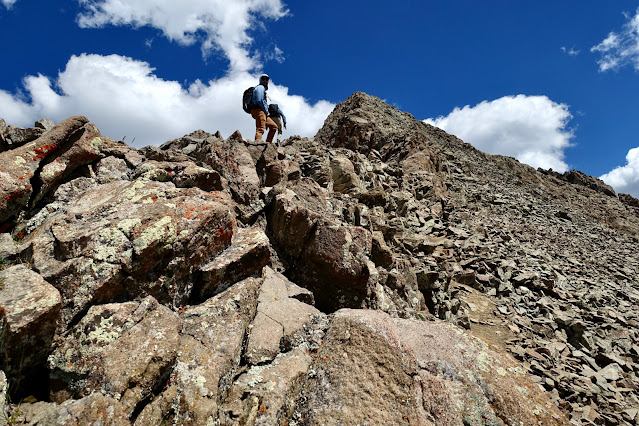
Round the corner and see up the wide south slope clear to the Sneffels-Kismet saddle, Lavender Col. It is a thrilling moment on the Standard Route. (THW, photo)
Pass through a gateway cairn at 13,000 feet. This marks the end of the engineered trail and the pathway splinters and braids immediately. The hardscrabble surface is resistant, slick and super steep. Look for buried boulders and nibs to push off from. Better yet, favor the talus on climber's left as the group in the previous photo was doing. I have been on Mount Sneffels four times, the first in 2004. The slope was challenging back then but not nearly as damaged from overuse as it is today. Please take good care not to dislodge loose rock in this shooting gallery, remaining constantly mindful of the climbers below you. If you have a helmet, wear it.
There is not any advantage to tagging the low point in Lavender Col, the 13,500 foot saddle between Kismet and Sneffels. Rather, contact the saddle on the west side. The highpoint of
Kismet, 13,694', shown, is hard to delineate from the rotten madness this peak dishes out. I once climbed the sub peak from Lavender Col but the summit is best approached from Yankee Boy Basin.
Lavender Col is named for Dwight Lavender born in Telluride in 1911. He and his older brother, David (
One Man's West), spent their summers on the family cattle ranch at the foot of Lone Cone. Dwight founded a loose collection of climbing enthusiasts, the San Juan Mountaineers. He, along with Carlton Long and Mel Griffiths, compiled the earliest guide to the San Juan and La Plata mountains,
San Juan Mountaineers' Climber's Guide to Southwestern Colorado. At age 23, Dwight returned to Stanford to begin graduate work and died of polio. His guide was consequently never published. Lavender
Peak in the La Plata Mountains is named for Dwight as well. My partner, Thomas Holt Ward, and I were so moved by Dwight's story, we were inspired to complete his work in the La Plata Mountains. Our book is dedicated to Dwight Garrigues Lavender,
La Plata Mountains: Comprehensive Guide to Peaks and Trails, published in 2024
. From the saddle, 2.7 miles, turn northwest into a couloir about 80 feet wide. The scrambling is Class 2+ over the next 500 feet of vertical. This couloir can hold snow well into summer. Ice axe and crampons advised.
I have always thought of the couloir as a fun scramble on stable rock but I've been corrected by friends who think it is a classic San Juan couloir with dangerous loose material. I've seen plenty of boulders flying out of control. I favor the wall on climber's right to brace from and duck behind. It is probably safer to stay out of the center.
The couloir tops out at 14,040 feet. Definitely go check out the northface tipping point either coming or going. Access to the mountaintop is through a crack shooting up to the west about 20 feet below the top of the couloir. The exit crack is about 30 feet of vertical finishing with a Class 3 move with some exposure on the left. This V-Notch is the crux of the Standard Route. Holds for hands and feet are skimpy. Search around and you will find sufficient holds to make the move safely.
The V-Notch has a distinctive face from the top side so turn around and make a mental note of its location for your downclimb. The best rock on the entire mountain is the last 100 feet of vertical to the apex. It is my favorite part of the climb. Over too soon! The weathered stone is a raspy granitic with strong, stable features. Mount Sneffels is surrounded by peaks composed of San Juan Explosive Volcanics. What makes this peak so exceptional and inviting are the igneous granitics that intruded into the older volcanics.
Arrive on the zenith of the pyramidal peak just shy of 3.0 miles after 2,900 feet of climbing. The crest is conical but comfortable with good sitting rocks all around, accommodating a dozen people at most. The image below looks southwest. With a rise of 3,030 feet the view is exceptional. I'll show more shots from the summit (and a word on the descent) at the conclusion of the Southwest Ridge Route. (THW, photo)
Southwest Ridge Route
In this image taken from the Standard Route, the southwest ridge looks like a series of sinister spears and spires. And yet, there is a way through the tormented geology. It's extraordinary that the ridge works out, especially given how it looks from the outside. Having said that, navigation is nuanced and not intuitive. You must know how to solve landscape puzzles. Carry a GPS track or go with a friend who knows the route. Link to
14ers.com for a description with images. This post might prove useful but it is not intended to get you up the mountain. Its purpose is simply to share my impressions and spread the joy this route imparts for experienced scramblers. Note, if you find yourself contemplating a move higher than Class 3+, you are off-route. Back out and try again.
From the Lower Trailhead, elevation 11,280 feet, walk west on the road for 0.9 mile to the Wrights Lake Spur. Moving from the road to the singletrack is an immense relief and immediate immersion in nature. In mid-August the tundra was enveloped with seedheads from summer's spent flowers. The trail skimmed us effortlessly through rivers of talus.
Wrights Lake, 1.3 miles, 12,180 feet, is a surprisingly small gem encased in a cirque at the head of Yankee Boy Basin. A couple of roads descend on the lake. The trail to the pass curves adjacent to the north bank. (THW, photo)
The
rock glacier streaming from Gilpin Peak was sourced from steep, north facing headwalls. The wall on the west side of the lake is along the frontal slope of the glacier. Stone essence, coupled with lake and sky create an irresistible study in gray and blue. At 13,694 feet, Gilpin is a Colorado bicentennial (ranked 149). The
standard route ascends its northwest ridge from Blue Lakes
Pass.
The trail to the pass affords opportunity to take a good look at both the south slope on the Standard Route and the southwest ridge. The route up the ridge begins on the west side, hidden from view in this image. The crux of the climb is in the vicinity of the pronounced gash mid-way to the summit.
At 2.1 miles, 12,680 feet, the footpath from the Upper Trailhead joins. (THW, photo)
If you parked at the Upper Trailhead it is only 0.6 mile and 240 feet of gain to this junction. (THW, photo)
Approaching any pass in the San Juan Mountains is revelatory.
Blue Lakes Pass at 2.4 miles, 13,000 feet, is rapturous. There is so much to see from the eastern boundary of the Mount Sneffels Wilderness. Below, image-left, are flow lobes of a rock glacier emanating from the Gilpin-Dallas ridgeline topped with T1, T2, T3, and T4. Technical Dallas Peak, 13,812' (LiDAR) is ranked 104 in Colorado. The highest of the Blue Lakes is at 11,700 feet, a substantial drop from the pass.
During the Pleistocene a river of ice flowed down the basins on either side of the pass leaving behind an ultra thin ridge at the head of the two cirque headwalls. The ridge we are about to climb is an arête, defined as a narrow ridge of rock separating two glacially-carved valleys.
The scramble climbs almost 1,200 feet in 0.7 mile. Allow one and a half to two hours to reach the summit assuming no major navigation blunders. At the base of the climb I stashed my trekking poles and put on my helmet. I was ascending with my son and partner who climbed the ridge two weeks prior and remembered flawlessly every twist and turn.
A social trail leaves from the pass and braids immediately. We took the high trail, hugging the initial wall of pinnacles on climber's right. I was immediately delighted by the quality of the rock. I braced off icy stone clinging to the silence, stillness, and solitude of night.
Hiking due north, holding to the wall, we had a good visual of the first chute. The route goes up and through the gully slicing between two massive pinnacles.
Above the initial wall, the route broadens and braids. We favored large solid talus over loose dirt tracks. I've annotated a few photos to give you a clearer visual of your optimum path.
The view from the southwest ridge is far superior to the Standard Route. A free-standing earth pillar overlooks the incomprehensible freakish beauty of this landscape. It is truly hopeless to take it all in. (THW, photo)
Seen from the spire above, a solitary individual stands in the center of Lavender Col. (THW, photo)
This image was taken from the south slope looking over to a group of people on the southwest ridge standing near the pillar. How could you not fall in love with the brilliantly-hued igneous stone that is Mount Sneffels?
The talus in the lower chute is solidly seated providing natural stairsteps as the pitch steepens. Watch continuously for headbangers literally everywhere. My helmet protected me when I rammed into a jutting rock.
The chute splits. Go into the gully on climber's right.
I felt like I was inside the ridge rather than on top. There was a sense of comfort in the narrow corridor of stone. It was steep, of course, but not exposed.
This image looks back down the chute to the initial wall of pinnacles and pass. (THW, photo)
At the top of the chute, there is a perfectly flat, short traverse over to the gap in the ridge.
The major gash at 13,500 feet is the navigational crux of the route and possibly the most exposed area. With standing rocks all around it's a wonder you can cross over the gap. Below, my climbing partners are on route, crossing the flat.
Looking at the image below, the objective is to climb the gully high in the center. To get into it, the safest bet is to stay high, avoiding the lower gully. I've drawn a red circle around a cairn that marks the preferred path. It's resting on a stone ridgelet you must climb. (THW, photo)
As we paused to get our bearings, a descending couple came into view. They were clearly in a state of exuberance and gave me permission to use their photo. Her hand is remarkably right by the cairn you must achieve.
Begin by dropping about 20 feet. The dirt is thankfully sticky. Move toward the wall on climber's left. Scramble up the rock rib aiming directly for the circled cairn.
My son and I are on the rock rib at the mandatory cairn. (THW, photo)
To enter the lengthy chute, pictured, the route crosses a stone bridge.
Drop about 20 feet onto the bridge. This is one of the aforementioned navigation pinch points. You have to nail this series of moves. Reflecting on the blade above the bridge, take a moment to marvel at the incessant verticality of this mountain. (THW, photo)
Cross the bridge, take a couple of steps to the right and enter the steep and narrow chute. This image looks back on the bridge and the blade. Many Class 3 pitches are concentrated in this gully. I love the structure and character of the chute requiring diverse scrambling skills. With my hands and feet all over the stone, I felt a sense of intimacy with the mountain. (THW, photo)
There are a couple of awkward Class 3 moves. For instance, you will come to a place where you must throw your leg and body over a block or do a Class 4 scramble straight ahead.
At the top of the chute, you have a choice. A trail advances into a rubbly gully on climber's left. This option works, eventually leading you back to the ridgetop. Alternatively, we headed to the right and immediately got on the ridgecrest, pictured. It's way cooler with better views and an obvious upward-leading ramp.
I had assumed we'd be on the razorback most of the time but, no, it took 640 feet of climbing to break out on top. There is some exposure on the ridgeline from here to the summit, visible for the first time.
Soon we encountered the weathered igneous rock so welcome on the last 100 feet of the Standard Route. The stone is well seated and the surface is grippy but holds are rounded. (THW, photo)
There was just one angular wall that pushed us briefly off to the east side of the ridge.
There is some exposure on the workaround. (THW, photo)
Take the first opportunity to climb back to the center.
The ridge tapers at 13,900 feet. There's a short stretch where the spine is one-boulder-wide. My partners took it standing up but I thought it was spooky enough to put my hands on the rock.
It's multiple choice up the summit block.
Top out on the diminutive and indomitable summit at 3.0 miles. Yes! This image looks down on a couple of climbers bracing with all fours as they near the summit block. Look to the east-west ridgeline to see T1-T4 packed in a tight line. Streams of castoff stone spread in successive waves of concentric curves.
Look over Dallas Peak to the horizon spanning from Lizard Head, over the Wilson group of fourteeners, to the
San Miguel threesome, and finally, to solitary
Lone Cone, the westernmost summit in the San Juan Mountains.
To the northeast is
Uncompahgre Peak, the monarch of the San Juans at 14,318' (LiDAR). Ridges swirl at random. Cirque Mountain whirls around to Teakettle Mountain and
Mount Ridgway. But then Teakettle whips over to Potosi by way of Coffeepot. Not to mention all the mountains of the Weminuche rippling off into oblivion. So much, too much, to take in.
Standard Route Descent
It is risky to descend on the southwest ridge if you have not just climbed it. It would be all too easy to get lost. In general, if you descend from any mountain on an unknown route and fail, you have no choice but to climb back up. You could conceivably exceed your energy, food, and water reserves, and expose yourself to an electrical storm. In contrast, it is never a problem attempting an unknown ascent. If you must turn around, you have completed your uphill effort for the day. We descended on the Standard Route because it was quicker and, frankly, we were mentally taxed and didn't want to think all that hard. Below, hikers are descending to the V-Notch located between the two knobs.
This group is on the playful 100-foot descent between the summit and the V-Notch.
I found downclimbing the V-Notch a little trickier than the upclimb. Having a spot is helpful. (Suzanne Fiorillo, photo)
Once back in the couloir, be sure to walk up to the top and look down the northface chute, typically climbed in the winter.
Back in the couloir, once again I favored the northeast wall. Be super mindful not to kick loose rock onto hikers below.
Trekking poles are helpful managing the tedious south slope. It is a welcome relief when the trail resumes at the gateway cairn at 13,000 feet.
Cruising down the road serves as a wind down after a glorious day on Mount Sneffels.
Mount Sneffels has such a distinctive shape it's easy to locate from disparate points afar. This image was taken from a neighborhood peak to the southeast,
T8 (Peak 13,315'). Find the earth pillar and gash! (THW, photo)
This final image was taken from the summit of
Wasatch Mountain, due south of both Mount Sneffels and Telluride. (THW, photo)