Travel: From Silverton, drive up Greene Street, the main drag. Zero-out your trip meter as you make a soft right onto San Juan CR 2. The pavement ends at 2.0 miles. On a good dirt road pass the turnoff to Cunningham Gulch in Howardsville at 4.1 miles. Pass the road into Maggie Gulch at 5.9 miles. Reach Minnie Gulch at 6.5 miles and turn right onto San Juan CR 24. The steep, rocky road climbs switchbacks before suspending itself on a shelf high above the gorge. 4WD (low helpful), moderate clearance, and beefy tires are necessary. In 7.8 miles, pass the first of many mine ruins and wreckage, some classically picturesque. Turn right at the fork at 8.1 miles. Treeline is at 9 miles. Park at 9.5 miles where the road switches abruptly left to end at the Esmeralda Mine. A sign indicates the trail is closed to all motorized vehicles.
Distance and Elevation Gain: 15.5 miles, 4,200 feet of climbing makes for a big day
Time: 7:30 to 9:00
Difficulty: Continental Divide Trail, Colorado Trail, off-trail; navigation moderate; appreciable exposure for 0.25 mile on Class 2 knife
Maps: Howardsville; Pole Creek Mountain, Colorado 7.5' Quads
Latest Date Hiked: July 22, 2014
Quote: Like sands through the hourglass, so are the days of our lives, and for that live moment we thrive. Binary Star
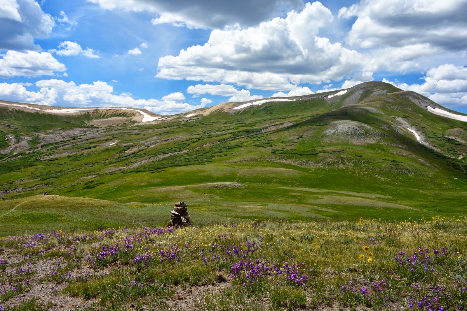
Descriptively named Half Peak. The 14'ers, Redcloud Peak and Sunshine Peak, are in the same neighborhood on the left.

Route: This is an out-and-back from the Minnie Gulch Trailhead. For a detailed description of all routes to Half Peak, including the Cuba Gulch and Cataract Gulch approaches consult, Colorado's Thirteeners: 13,800 to 13,999 Feet, by Gerry and Jennifer Roach.

From the trailhead, elevation 11,520 feet, cross a streamlet and walk south-southeast up Minnie Gulch. This image looks back at the trailhead.

In mid-July the wildflowers are unbeatable. They flow out of rocks and spill down the hill.

They cross the trail and tumble to the bottom of Minnie Gulch. The scene looks like a Pointillist painting by Georges Seurat. I scribbled down the names of 27 bloomers while covering the first mile.

The path eventually becomes marshy and braided. Just stay above and east of the creek. There is no need to doggedly stay on the trail to the head of the broad valley at 12,760'. Instead, at about 12,550', turn east and ascend a grassy slope, working around islands of rock, to 12,745' at 1.6 miles. Here you will meet the Continental Divide Trail (CDT) and Colorado Trail (CT) sharing the same treadway (N37 49.685 W107 31.181). Where you hit the trail is less important than securing it. Cairn edifices are so herky and beautiful, there must have been a cairn creation contest. This image shows the head of Minnie Gulch and Middle Mountain ridge. (THW, photo)

The hike ambles along the CDT/CT for the next few miles. Turn north, and gradually climb to meet the Continental Divide at Ridge 13,000'. Pass this Parry's primrose showing off.

On the broad ridge at 2.3 miles, two trails meet. One path, blocked off with rocks, leads north passing a small pond. Avoid this trail unless you want extra credit for climbing Cuba Benchmark, 13,019', shown 0.3 mile away. (THW, photo)

The straightforward approach is to stay on the CDT/CT. The GPS track above reflects exploration in this area: if you wish, climb Pt 13,041' before cutting cross-country down to the main trail. However you go, there is no way to avoid losing 400 feet before climbing once again. This is the first of two places the route gives up considerable elevation on the way to Half Peak. This image shows the first view of the mountain, Cuba Gulch, and a CDT/CT cairn.

One autumn there were four elk herds in the upper reaches of Cuba Gulch.

After the elevation loss, the trail climbs gradually over the next two miles, heading ever east, until it tops out 300 feet shy of ranked Pt 12,990', seen below after an autumn dusting. It would be an easy climb going or coming.

Staying on the crest of the Continental Divide, the trail nevertheless descends again, dropping 500 feet. Then, it surmounts a steep incline to arrive at the base of Pt 13,164', a ranked 13'er, seen below.

Half Peak dominates the landscape as the trail bends around Pt 13,164'.

At 6.1 miles, reach the base of the mountain. Leave the trail for the final 1.6 mile climb to the peak. Cut east just past a typically muddy area (N 37 50.810 W107 28.232). The climb is gentle for the first 0.5 mile. Stay close to the west side of the broad base, near the cliff. After a roller, The Trudge begins as the grade steepens for the next 0.7 mile. Walking is accommodated on a uniformly gravel surface. At 7.3 miles, the mountain squeezes to form the "Neck Of The Hourglass." For the next 0.25 mile the exposure is grave, dropping over 400 feet on either side. Walking on the almost flat constriction is simple but the rock is not dependable. There is a lot of loose material mixed with good-enough footholds. Stay on top of the ridge except when forced off to the west side, graced with scraps of social trail.
(THW, photo)


Return to the rib and stay on it until the pinch, quite suddenly, opens broadly onto the summit plateau. Continue on the same trajectory, crossing the top of the hourglass, and reach the peak at 7.7 miles. The high point is elusive; there is no registry. However, the 800 foot north face cliff edge is abrupt, even undercut. A rock glacier fans out from the base. (THW, photo)

The view from Half Peak is one of the best in the San Juans. See the distinctive summit from everywhere; see everywhere from it. Wetterhorn Peak, 14,015', is in the center of the image below with Matterhorn Peak, 13,590', to its right, and then Uncompahgre Peak, 14,308'. Handies Peak, 14,058', is less than 4 miles to the NW, just left of the photo. Turn around and the vista is equally large-caliber.

Tip the hourglass over, returning as you came. The flow of time slows while crossing the Neck, the speed regulator. (THW, photo)

The image below shows the trail ascending the minor pass left of Pt 12,990'.
Regain Ridge 13,000' by walking through an emerald green saturated landscape.

Stay on the CDT/CT a good half mile into Minnie Gulch before short-cutting to the trailhead connector. A fantastical, prize-winning cairn guides the traveler while Sheep Mountain dazzles with cloud-defying sunlight.

No comments:
Post a Comment