Travel: From the US 550/160 intersection in Durango, drive north on US 550. Crest Molas Pass at 41.0 miles, Mile Marker 64. Take the signed left towards Little Molas Lake at 41.4 miles. Drive on a good dirt road, passing an established campground, and park at the Colorado Trail TH at 42.5 miles. Allow 50 minutes from Durango.
Distance and Elevation Gain : 10.7 miles; 3,600 feet of vertical
Time: 6:00 to 8:00
Difficulty: Colorado Trail, social trail, off-trail; navigation moderate; some exposure on west slope of Grand Turk;
Class 2
Maps: Snowdon; Silverton, Colorado 7.5 Quads
Latest Date Hiked: August 18, 2022
Quote: Deep in their roots, all flowers keep the light. Theodore Roethke
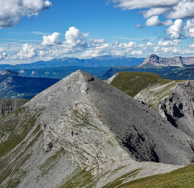
Grand Turk and Sultan Mountain, the double prominence on the right, 4,000 feet above Silverton, viewed from Macomber Mountain.

Route: The classic route up all three peaks is where you dream it to be every time you drive over Molas Pass, shown. From left to right are: West Turkshead Peak, The Cleft, East Turkshead Peak, and Grand Turk. A social trail goes through The Cleft just right of the snow field.

Map: The trek is an out-and-back. Make it a five peak day by adding Point 12,899' and West Turkshead Peak, 12,849', indicated by the blue line. For a shorter, alternative route into "Valley of the Turks," see the end of this post.


Continue on the trail as it heads northeast up the broad ridge. Buttercups pump out wattage, highlighting ever beckoning Snowdon Peak.

At 2.0 mile, 11,640 feet, there is a closed trail going east. Leave the Colorado Trail and ascend north-northeast up the ridge until you reach 12,000 feet. The idea is to get around the base of Peak 12,849' ("West Turkshead Peak"), and contour into the "Valley of the Turks".

Be sure to swing around and look at the peak line-up: the Twilights, Potato Hill (aka Spud Mountain), and Engineer Mountain. The treadway will guide you home on the return.

There are remnants of an old road on the ridge. The route skims just above the largest patch of willows as it curves around West Turkshead Peak.

The Valley of the Turks awaits. Pick your way through the sky pilots, around patches of corn husk lily, across shallow drainages and stretches of slippery dirt. Finally, pass very near a few large boulders that tumbled off the Telluride Conglomerate rim.

As you contour, keep a bead on the obvious trail that runs up through the cleft. Cross the creek well up the valley at about 12,000 feet, 3.0 miles. Pitch steeply up alongside a shallow gully for about 150 feet to intersect the trail. Turn north and allow the track to guide you through the appealing cleft at the apex of the valley. This area holds snow quite late so don't push the season on this hike.

The lichen on the conglomerate is so orange. The king's crown so red. The alpine avens so yellow. You'll find yourself thinking you are in an exotic magical kingdom and surely a genie is going to appear and grant you three wishes. If three peaks are your heart's desire, you are in luck!

From the cleft top, walk on a faint trail NNE under Point 12,899'. Head directly for the saddle north of this point and south of Spencer Peak (Point 13,087' on topo), shown. Don't shortcut and miss the saddle.


From the window turn east and scramble through an outcrop to attain the west ridge of Spencer Peak.

Sultan Mountain
The trail climbs the west ridge and then, about 50 feet from the summit of Spencer, contours below the crest on a good trail to attain the NNE ridge. While our route saves Spencer for the return, it would be easy to simply go over the top. This image was taken from Spencer's NNE ridge. Sultan is on the left, Grand Turk, the right. Notice carefully, a social trail that skirts Grand Turk, a thin thread crossing the west slope at 12,800 feet. Many people will use this shortcut with nary a thought of danger. I find it frightening. The 0.3 mile trail is a thin, off camber trace. Much of the path is on decent rocky chunks but there are sections of loose, slippery dirt and hardscrabble that threaten to slide one into the brink. In 2022, I went up and over the ridge in both directions.


Here's a closeup shot of the trail flanking Grand Turk on the west. (Thomas Holt Ward, photo)

Clinging to the slope along the unpleasant thread are pale sky pilots that waft an elixir of lavender and rose.

From Saddle 12,776' north of Grand Turk, it is a quick and lovely walk up the south ridge of Sultan Mountain.

From the 13,368' summit at 5.1 miles, the vista is so spiked and complicated it is mind-numbing. The Ice Lake peak cluster in the west includes the color summits: Vermilion and Golden Horn.

Be sure to traipse a mere 0.1 mile NW to Sultan's subsidiary summit. From there, I am checking out Silverton, distinctive Half Peak, and a string of fourteeners. (THW, photo)

Grand Turk
From Saddle 12,776' north of Grand Turk, it is a quick and lovely walk up the south ridge of Sultan Mountain.
From the 13,368' summit at 5.1 miles, the vista is so spiked and complicated it is mind-numbing. The Ice Lake peak cluster in the west includes the color summits: Vermilion and Golden Horn.
Be sure to traipse a mere 0.1 mile NW to Sultan's subsidiary summit. From there, I am checking out Silverton, distinctive Half Peak, and a string of fourteeners. (THW, photo)
Now for Grand Turk, as seen from Sultan. The Silverton 7.5 topo mistakenly names the third knob to the east the peak at 13,148'. The eminence is actually 13,167', the second prominence. You will find the peak register there. In 2022, the peak register was missing.

From Sultan, return to the saddle. I always feel like I'm on a two lane bridge that falls off decisively on either side. Climb directly up Grand Turk's NW ridge. This short expedition is pure pleasure so don't miss it. Look down vertical chutes to the NE. It is a tundra walk from the first prominence to the peak at 6.1 miles.

Spencer Peak
From Sultan, return to the saddle. I always feel like I'm on a two lane bridge that falls off decisively on either side. Climb directly up Grand Turk's NW ridge. This short expedition is pure pleasure so don't miss it. Look down vertical chutes to the NE. It is a tundra walk from the first prominence to the peak at 6.1 miles.
Spencer Peak
To reach Spencer, seen below, swing over and down to meet Grand Turk's SW ridge and drop 400 feet to the saddle. There is a use trail clear to the crest at 6.7 miles. Spencer has two faces. On the south it looks like a smooth, green ball. On the north, it's a cone culminating on a perfect, gray point. In 1989, the mountain was officially named for Donald Spencer, an esteemed mathematician who lived for a time in Durango. (THW, photo)
To return to the trailhead, descend the west ridge of Spencer and rejoin your in-coming route.
Point 12,899' and West Turkshead Peak, 12,849', Optional Additions
Do you wish for two more? From the Window of Towers, climb the east ridge of Point 12,899' and go down the south ridge. Or, go around it. From its southern base at 12,500 feet, climb the east ridge of West Turkshead until you intersect the north ridge. Ascend on tundra to the summit, 0.5 mile from the saddle.
East Turkshead Peak, 12,734'
Below is an image of East Turkshead taken from the slopes of Spencer. The peak is the knob in the center of the ridge. Once, we approached it from the west and got turned back at the vertical cliff just before the summit block.
Alternative Route into Valley of the Turks
This shortcut approach to Valley of the Turks (black line) saves 1.2 miles each way relative to the standard route that starts on the Colorado Trail (blue line). It requires a bit more navigation savvy.

Measuring from the main parking lot, walk back up the incoming road for 0.25 mile. Pass two closed trails, signed. Turn north onto a distinct dirt path that heads into the timber. The trail soon dissipates but fragments reappear now and then. Hold a north-northeast bearing on a subtle ridge to about 0.7 mile. Turn north-northwest and climb a series of benches. Catch frequent glimpses of West and East Turkshead peaks framing Valley of the Turks. I find it helpful for route finding to take aim on West Turk.

I hesitate to use a tree as a navigation aid but so long as this scorched tree is standing, it signifies that you are on the proper route. From there, keep heading up, staying well clear of the boggy, willow-infested creek. A social trail materializes by a jutting, triangular conglomerate boulder.

The path crosses to the east side of Molas Creek at 1.4 miles, 11,680 feet. Make your way into the valley and do a rising traverse to the cleft trail at about 12,000 feet.
In September, 2021, we started out on the shortcut route. Domestic sheep were grazing in the valley and two white guard dogs did their best to intimidate us for a good distance. We took the standard route back to the Colorado Trail. This image shows the shallow gully we used to transition from the cleft trail to the 12,000 foot, willow-free contour on the west side of the valley.

10 comments:
Would these peaks be okay to ascend this week, the week of 11/19/18
It would be a snow climb: carry snowshoes, ice ax, crampons, and check the avi hazard before you go. Debra
Would dogs be able to hike this trail safely?
If you love your Dog Beings? Please, leave Them at home...technical difficulty is high especially tagging Sultan and technically? All Dog Beings in Wilderness should be leashed ... It's a lose/lose for both Two and Four Leggeds on this one if you insist upon bringing your Dog Beings up these peaks.
Thanks for the appropriate reply, Steve. I totally agree. Debra
No problem with my dog on all three summits. The only diversion that was necessary was to avoid the outcrop scramble at the cleft before spencer peak. If you go slightly west there is a loose but short path around the rock. The rest of it is gravy. Leashed when necessary. There are marmots along the way, and they move quite slow so be aware.
Did you note Debra’s comment about the sheep with guard dogs? I’d skip bringing your furry companions, as even leashed animals would be considered a threat by trained sheep dogs.
Sad to say the “stalwart tree” has finally succumbed and was prone on the ground today. (Lynn Wynn just hiking a bit on the CT this morning)
Lynn, This is sad news indeed. That tree was (and still is) an old, dear friend. Debra
RIP Bates Tree!
Post a Comment