Travel: At the junction of Utah State Route 12 and Hole-in-the-Rock Road, set your trip meter to zero and drive south. Expect some washboard on the maintained broad surface. After 10.6 miles, turn left at a sign for Harris Wash. The side road bears east while crossing a euphedra and juniper plain. Veer left at 13.3 miles. Pass primitive camps with superb views. The road goes over a rise and then winds down, crossing a couple of washes. Take the left fork at 15.9 miles. Rabbitbrush, sage, and cottonwood edge the canted road. There are whoop-de-doos in the soft dirt. Park under a big cottonwood at the Harris Wash Trailhead, 16.7 miles from Highway 12. 4WD is recommended.
Distance and Elevation Gain: 11.2 miles; 1,000 feet of climbing
Time: 5:00 to 7:30
Difficulty: Off-trail; navigation challenging; numerous Class 3 chockstone obstacles and a lower Class 4 friction pitch with exposure
Map: Red Breaks, UT 7.5 USGS Quad
Reference: Canyoneering 3: Loop hikes in Utah's Escalante, Steve Allen, 1997.
Latest Date Hiked: April 18, 2017
Poem:
We think we choose our own path,
Until in canyons we stray,
And find our intentions bounced from wall to wall,
Our illusions winked out in profound shadow,
And our conceits dissolved in bright and clear and beckoning pools.
Thomas Holt Ward
The confluence of Red Breaks Canyon and the East Fork. (THW, photo)

Route: Walk north from the trailhead. Cross Harris Wash and enter Red Breaks Canyon. Where the canyon divides into the Upper West Fork and Northeast Fork, branch right. Exit the Northeast Fork and gain the pass between Points 6,015' and 5,887'. Descend the East Fork and drop back into Red Breaks Canyon to return to the trailhead. The blue-line is an alternate route from the Old Sheffield Road parking area to the pass between the Northeast and East Forks. A map detailing access to Big West Fork from the west side of Red Breaks follows.

An established path links the trailhead, elevation 4,960 feet, to Harris Wash. Cross the huge drainage and locate a dirt road leaving the wash on the opposing bank. The road drops into Red Breaks Canyon at 0.3 mile and continues up the other side at a massive cottonwood. Leave the road and bear left/north up Red Breaks Canyon.
Stay in the broad, main wash. It's not a pretty entrance and, frankly, the first mile is kind of a drag trudging in deep sand. The low, red hills bordering the channel are in the Carmel Formation. The resistant limestone cap slows the erosion of the underlying sandstone.
At 0.9 mile, Navajo Sandstone comes up out of the ground and the canyon narrows. Reach a 20 foot barrier fall at one mile. Climbers can opt for the Class 5 pitch up-canyon-right (UCR). We backed up about 50 yards and climbed out UCL. A clear path runs along the west rim. It is not marked downcanyon but there is a major cairn at the upper end of the 0.2 mile bypass trail. (THW, photo)
Upon reaching the floor, the canyon splits. Red Breaks Canyon is to the right. Walk on deeply incised, sculpted bedrock with fluted chutes directing into water-filled tanks. Tamarisk gives way to juniper lining the clean bottom. Paradise interplays with unremarkable stretches of rubble and deep sand slogging.

The inner canyon narrows to six feet, three feet, six inches, with walls fanning out to permit passage. In the lower slot there are about five Class 3 chockstones that require jockeying. Some hikers will need a helping hand, packs off.

The slot continues for about 0.3 mile and the pace is slow. The second set of narrows has deeply fluted, cross-bedded walls. (THW, photo)

Pass the suspended East Fork confluence UCR at 2.3 miles. The Big West Fork joins Red Breaks Canyon UCL at 2.6 miles. The impassible fall is stunning with vertical funnels. Stay in the main canyon.
The 1.2 mile Big West Fork slot is reportedly the most beautiful in the area. Chockstones are numerous and challenging. Bypass directions are at the end of this post. (THW, photo)

Red Breaks Canyon widens and constricts repeatedly. Chimney a ten foot dryfall. Bypass a 15 foot jump.

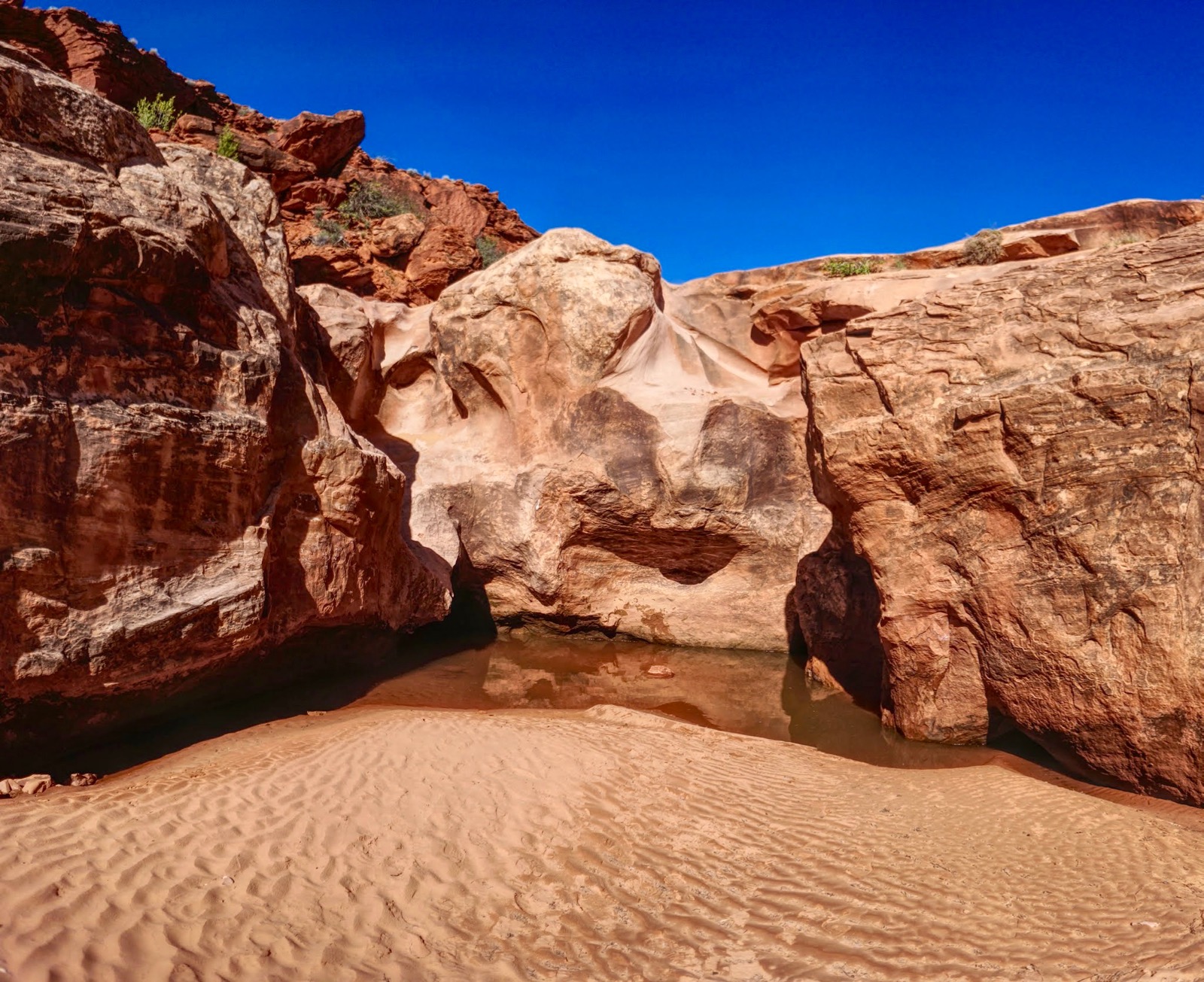
Walls lower and creamy stone intercepts a sandy corridor signaling an upcoming canyon division. (THW, photo)

A two-tiered fall with a deep waterpocket in the middle is located where Red Breaks Canyon divides into the Upper West Fork and the Northeast Fork at 3.7 miles. Our route goes into the Northeast Fork, UCR. For me, this junction is the most aesthetically pleasing scene in the region. (THW, photo)

The canyon constricts and 0.1 mile ahead is a high, impassible fall with a pool. Backtrack to the top of the two-tiered fall. The bypass is located on a broken slab between the canyons. The lower Class 4 friction pitch is about 80 feet.

At the top of the incline, Point 6,015' is visible at the head of the Northeast Fork. It is an exhilarating moment.

The intermediate bench segues back into the canyon. The next one-mile segment is simply outrageous--big, broad, and beautiful. Liesegang paints swirls and streaks on bedrock. Sand fills low places as water. Tanks are deep. There are no obstacles. (THW, photo)

Ascend the softly rounded amber-colored floor.

Textures vary radically.

Once clear of Point 5,887' and closing in on Point 6,015', shown, leave the canyon and bear east to a minor pass at 5,780 feet.

Note: Inselberg Pit, one of the largest cylindrical sandstone weathering pits on Earth, is relatively close by. This is the point where the navigation savvy may divert.
At 5.6 miles, drop off the softly rounded pass into the East Fork. Like the Northeast Fork, the canyon is unusually welcoming, even broader and flatter, the total opposite of a slot. The aeolian process has scoured the canyon floor silky smooth. There are a series of soft funnels to pass through.

Moqui marbles are attached to underlying sandstone. To learn how the iron concretions are formed, consult Becky Oskin's article in Live Science. (THW, photo)

Stone displays hues of pearl, ruby, bronze, and garnet-colored dotted lines. (THW, photo)

An ephemeral pool in the East Fork. (THW, photo)

A checkerboard wall interrupted and enhanced by erosion. (THW, photo)

The canyon constricts and shoots into a keeper pothole. Bypass DCL, descending a friction pitch back into the canyon.

The passageway slots up. We turned around just before the pouroff at the Red Breaks confluence at 8.3 miles. Now you have route options. The first I have not done. Back up until you can climb onto an intermediate, east-side bench. A distinct trail goes down to the confluence where there is reported to be access into Red Breaks Canyon. Retrace your steps down the slots and back to the trailhead.
We chose to backtrack 0.2 mile to elevation 5,280 feet. Look for a gap in the east rimrock. This is an easy escape route onto the Navajo caprock framing the inner canyon. From here, follow the rim downcanyon. Avoid trampling the inches-thick cryptobiotic soil crust broken only by cougar tracks. This rim image looks down the East Fork toward the confluence with Red Breaks Canyon. (THW, photo)

The image below depicts the dramatic, suspended confluence.

The ledge walk is pleasant. There are occasional cairned routes to the canyon floor. We played out the rim until it grew tiresome and reentered Red Breaks Canyon via a minor branch at 9.9 miles. From here, we simply retraced our steps to the trailhead.
Note: A variation on this hike may be done from Old Sheffield Road. It is 2.75 off-trail miles from the parking area to the pass between Points 6,015' and 5,887'.
Big West Fork From Old Sheffield Road (May, 2017)
This shortcut route to the Big West Fork is much quicker than coming in from the Harris Wash Trailhead.

Travel: Old Sheffield Road is off Highway 12 between Escalante and Boulder, UT. At mile marker 70 (where a cattle guard crosses the highway), turn south on a dirt road suitable for 2WD with good clearance. The road splits in Big Spencer Flats, 5.8 miles from the highway. Veer right/south staying with the main road. Drive another 2.6 miles across a sage flat north of the Red Breaks cliff face. Two standing logs mark the end of the road at a drill hole and cattle tanks.
From the parking lot at elevation 5,740 feet, either cut directly across a dune field or take a social trail southwest onto a sandstone apron. Pass a multi-hued bowl with scattered iron concretions. While passing south of Point 6,136', get a visual on the weakness in the well-armored Red Breaks escarpment, shown. It is a simple Class 2+ climb to the mesa top just shy of 0.8 mile, 5,940 feet. A large cairn marks this location for the return.

The terrain on the Carmel Formation surface is broken by small drainages and hills. Head southeast on red earth with rock chips and well spaced foliage in a piñon-juniper forest.
In 2.1 quick miles, reach the rim of the Big West Fork, hopefully about 0.3 mile from the confluence, shown below. At a break just south of a small drainage, descend from the mesa to a mid-level bench. If you want to head up Big West without delay, walk down the small sandstone bowl to the floor of the tributary, 2.2 miles from the trailhead.
(THW, photo)

Before going upstream into the slot, walk a few paces downcanyon to the barrier fall with its exquisite vertical fluted water chutes.

For those who want to get into Red Breaks Canyon, follow the clear trail on the bench south for 0.2 mile. Descend a mild friction pitch to the floor of the main canyon, shown (N37 39.922 W111 20.535). For those continuing upcanyon, enter a slot with one chockstone. Reach the Big West/Red Breaks confluence in 0.2 mile.
If you are coming up Red Breaks from Harris Wash and you overshoot the Big West Fork bypass upcanyon-left, you will know upon reaching the confluence. Backtrack through the slot to the bypass.

We only made it 0.3 mile up Big West and missed most of the premier slot. The first chockstone is great fun.
(THW, photo)

The fifth chock was beyond my ability level. The captured boulder is 12 feet tall with a water scoured six-foot hole beneath. I couldn’t find decent holds and had to concede. However, a couple of serious climbers happened along and commandeered it beautifully. Bring a line for hoisting packs. According to the literature, a more challenging chockstone awaits upstream. (THW, photo)

An important note from author Steve Allen about protecting endangered National Monuments in Southern Utah.
No comments:
Post a Comment