Travel: From the US 550/160 intersection in Durango, drive north on US 550 for 24 miles. Turn left at Needles Country Store, Mile Marker 46.2. Gas, water and snacks are available. Trailhead parking is at the south end of the commercial cluster, just north of a corral. Allow 30 minutes from Durango.
Distance and Elevation Gain: 5.6 miles roundtrip and 1,650 feet of climbing; the optional loop extension adds 0.8 mile and 100 feet of gain
Time: 3:00 to 4:30
Difficulty: Trail most of the way; navigation moderate; no exposure prior to precipitous clifftop
Map: Electra Lake, Colorado 7.5 Quad, or Trails Illustrated: Durango, Cortez #144
Latest Date Hiked: June 3, 2025
Navajo Prayer:
In beauty may I walk
With beauty before me, may I walk
With beauty above me, may I walk
With beauty below me, may I walk
With beauty all around me, may I walk
In beauty, may my walk be finished.
US 550 traverses the base of the Hermosa Cliffs. Morning color flames the flanks of Castle Rock in autumn. In winter, the cliffs are framed by white aspen trunks. In all seasons, handsome Hermosa is a powerful, magnificent beauty.

Route: Elbert Creek Trail #512 wends up the east-facing slope of the Hermosa Cliffs, staying north of the drainage. The Castle Rock route leaves the trail at two miles and moves northeast on a well-established social trail. Finally, climb the gentle, west flank of Castle Rock. Walk east along the south cliff edge to the high point. Return as you came or extend the trip with an optional loop, shown.

This image of Castle Rock and Needles Country Square was shot from the trailhead parking area.

The multi-use trail welcomes hikers, mountain bikers, and equestrians.

From the trailhead, elevation 8,800 feet, walk west beside a working corral. The Forest Service issues grazing permits in the summer. Close the gate behind you. In February, 2015 the San Juan Mountains were suffering from a dry winter. We carried snowshoes and used them near the top. Start out in the morning when the mud is frozen. More normal for February would be a snowshoe hike in deep snow.

The track crosses Elbert Creek at 0.3 mile. While the stream is typically under snow in winter, the crossing is tricky when the water is high. The trail makes two long traverses as it switchbacks up the east-facing grade. Aspen are sun worshipers so naturally they predominate; this is the most dazzling autumn hike in the region. In winter, pass through a monochromatic lower story world of perfectly vertical white trunks and long, slender shadows. The ceiling contrasts with ravishing Colorado cerulean.

At 1.2 miles, the path rounds the corner and gradually climbs a south-facing slope. Hear the turbulent creek plunge down the ravine. On this warm aspect, a few Douglas fir and Rocky Mountain juniper hang on while aspen thrive. As the drainage narrows and shade thickens, so do Engelmann spruce and subalpine fir. A spring trickles out from under the trail and down a wooden flume, forest gives way to meadow, and a perfectly placed, historic line cabin is reached at 1.8 miles, 9,800 feet. The chinked log building is the property of the San Juan National Forest. It is locked and not open to the general public. Range riders sometimes stay here in the summer. For the rest of us, the front porch offers protected bench seating.

Continue past the cabin in the open valley to a fabricated post at two miles. Leave the Elbert Creek Trail, hooking a sharp right onto a well-established social trail that climbs northeast up a south-facing hillside, shown below.
Note: The Elbert Creek Trail, an east/west lateral, carries on until it intersects the north/south Hermosa Creek Trail #514, eight miles past the cabin. Elbert Creek Road #581 is one mile west. A right turn on #581 leads to Durango Mountain Resort. The road is open to 4WD traffic in the summer.

The trail transitions from the open slope into a deeply wooded, often chilly drainage at 2.2 miles. Climb 300 feet over 0.2 mile. The pitch softens and the thick forest abruptly gives way to a pastoral valley. As soon as you are in the open, start looking for a cairn that marks a faint track to the right/southeast. In winter the cairn is not visible but snowshoe tracks frequently show the way.

Ascend the west flank of Castle Rock. The woods are a little tangled in here but after about 100 feet of climbing and 0.2 mile, you will pop out on the abrupt, south rim of the escarpment. The unforgiving aerie is sure to leave you breathless and backing away from the drop.
Geological note: According to John Bregar, geologist, probably several times during the geologically recent Pleistocene epoch, ice in the glacially carved valley, over 1,600 feet below, thickened to reach nearly to the top of the cliffs. The Hermosa Formation dates to the Pennsylvanian period, approximately 300 million years ago. The cliffs consist of alternating beds of limestone (deposited when sea levels were high) and sandstone (deposited when sea levels were low) with intervening layers of silt and shale. The sea level fluctuations correlate with glacial and interglacial episodes, similar to what occurred in the Pleistocene.

Walk east, round the corner to the north, and reach Castle Rock at 2.8 miles. The San Juan Mountain celestial skyline is as sweeping as it is startling. To the east at center, Pigeon Peak and Turret Peak upthrust in their jaggedly way. The bulkier Twilight Peaks in the West Needle Mountains are on the left. Mountain View Crest contrasts with its visually flattened top on the right. Highway US 550, of course, runs along the base. East of the road is Electra Lake which drains into the Animas River.

There are pleasant sitting ledges back from the no-nonsense, 800 foot cliff face. You needn't to be as daring as these two. The integrity of the rim rock is inconsistent so settle onto a comfortable picnic perch.

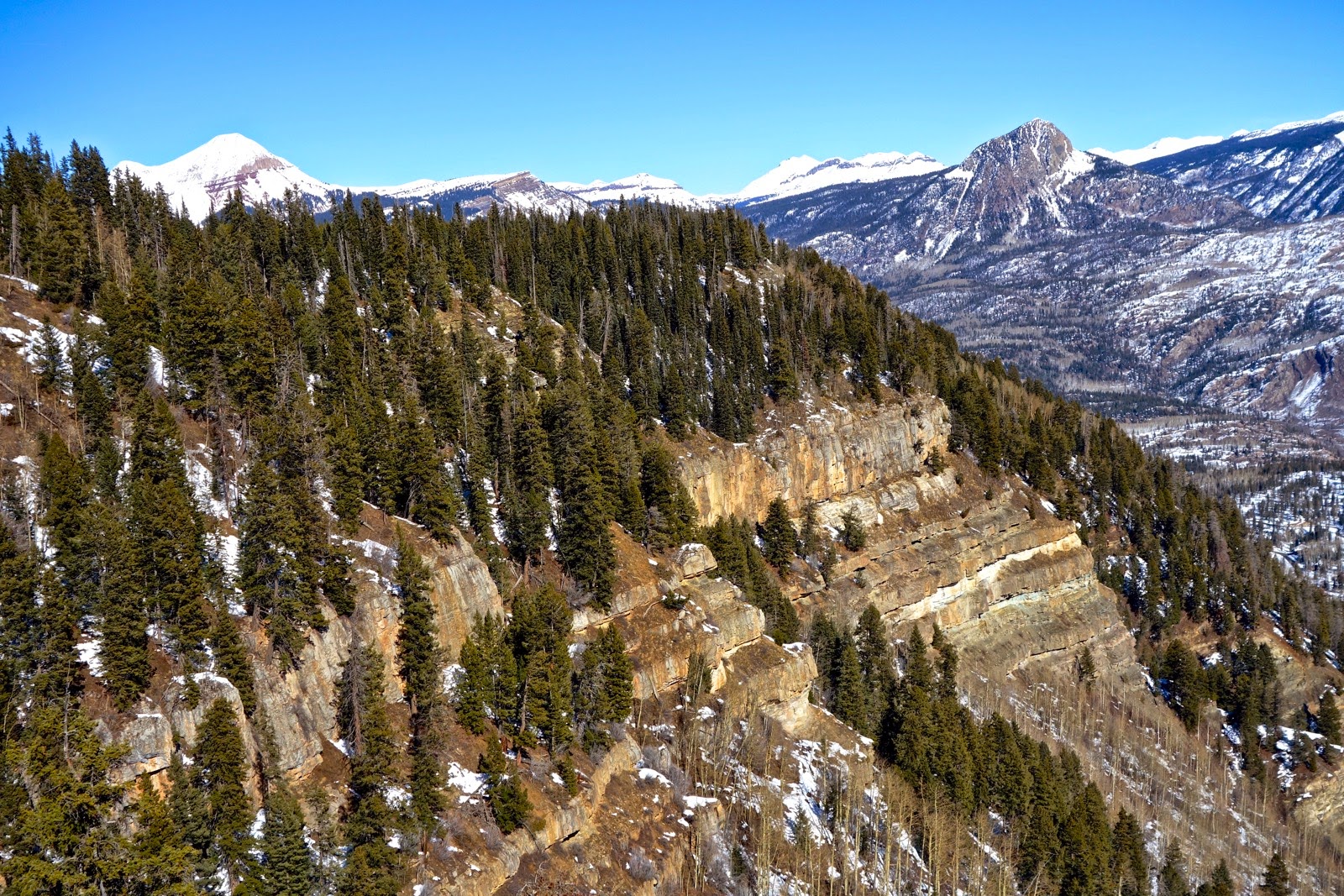
Return as you came or proceed north 0.5 mile, paralleling the cliff edge at a serene distance to arrive at another promontory with a striking look back at Castle Rock. Engineer Mountain and Potato Hill, "Spud Mountain," frame the north, as seen in the image below. Until 2014, there was a memorial in the depression between the two high points commemorating Joe Ehrich, 37. On April 21, 1986, Joe tragically fell 800 feet to his death when he drove his snowmobile over the cliff. The two friends accompanying Joe speculated that the sun's morning reflection gave him the illusion there was a clearing through the trees ahead. In reality, the snowfield was thin air.
To complete the small loop, walk west on a social trail for 0.1 mile into an open valley. As shown on the map above, turn left/south on a social trail to rejoin the incoming path. Animal tracks imprinted in snow are easy to identify. I have seen elk, deer, lynx, squirrel, snowshoe hare, grouse, and turkey.
In summer, red columbine and heart leaf arnica bloom beside the lower trail; lupine are lush around the cabin; and the charmed will find fairy slipper orchids living in the shady, moist woods. While this hike is popular and wondrous all year, many locals make an annual pilgrimage in autumn.

3 comments:
Thanks so much for this write up of the trip. We can see the cliff face from our cabin and are looking forward to hiking it tomorrow.
A group of 5 snowshoed up to the cabin last night. It was a full moon in a clear sky. One of our group commented:
"What we saw, and felt, few seize the opportunity to see in real life. The lighting and shading of the full moon on the trees and on the snow, that certain but ever changing hue, fully illuminated paths, still silence but for the crunch of the snow beneath us. Free, but Priceless" Joseph
I'm blissing out on your gorgeous, descriptive, and poetic rhapsody.
Post a Comment