Eureka Dune's 650 foot sand mountain contrasts with the banded Last Chance Range. (THW, photo)

Travel: Fuel-up at Stovepipe Wells. (It'll cost you.) Carry all the water you will need. Drive east on CA 190 for 9.0 miles to Scotty's Castle Road. Turn left/north and drive 33 miles to the Grapevine Entrance Station. Turn left toward Ubehebe Crater. At 2.6 miles, turn right onto Big Pine Road, dirt, and drive through the northern end of Death Valley for 21.3 miles to Crankshaft Junction. The signpost is made from a hefty crankshaft. Stay left. Climb to the top of the Last Chance Range on a windy, steep road with washboard. In 7.4 miles, asphalt assists the curvy downhill through brightly colored Hanging Rock Canyon for 5.0 miles to South Eureka Road. Turn left/south. The dirt track narrows and the washboard is hideous. It is 10.0 miles to Eureka Dunes and the dry campground at its base. To reach the trailhead for Hidden Dunes, drive south on South Eureka Road for 3.5 miles. Look carefully for a track on the right that punches over a berm before becoming defined. This is the only obstacle that will likely stop a 2WD vehicle. (You won't get this far without sturdy tires and moderate clearance.) Drive west across the raw desert for 2.4 miles, mostly smooth and flat, with a few whoop-de-dos and shallow washes. Park at a wellhead beside a whitish mound. At the end of this hike, drive back to South Eureka Road and turn right/south. The Eureka Dunes campground is another 6.5 jarring miles away. It is 88.3 miles from Stovepipe Wells to Eureka Dunes without the Hidden Dunes spur.
Hidden Dunes
Distance and Elevation Gain: 9.5 miles; 1,300 feet of climbing (Your stats will vary.)
Time: 4:00 to 6:00 (You can wander for days.)
Difficulty: Off-trail; navigation moderate (but critical!); no exposure; carry all the water you will need; no refuge from the sun so avoid during the hottest months; wear protective clothing on windy, sandblast days
Maps: Hanging Rock Canyon; East of Joshua Flats; Last Chance Range SW, CA 7.5 Quads, or Trails Illustrated: Death Valley National Park, #221
Reference: For a poetic rendering of the dunes, more hiking suggestions, and lessons in geology and natural history, consult: Hiking Western Death Valley National Park: Panamint, Saline, and Eureka Valleys, Michel Digonnet, 2009.
Date Hiked: April 2, 2015
Quote: I have always loved the desert. One sits down on a desert sand dune, sees nothing, hears nothing. Yet through the silence something throbs, and gleams. Antione De Saint-Exupery, The Little Prince
Route: Hike southwest for three miles to The Gap in the Saline Range. Hidden Dunes is on the west side of The Gap. A loop hike to Pt 3,960' is suggested but you may wander freely. However, you must come back through The Gap to return to your vehicle.

Before leaving the wellhead trailhead at 2,974 feet, have a strategy for locating your vehicle at the end of the hike. The wellhead mound is white and can be seen from far off so it makes a reasonable navigation marker. However, it takes the sharpest eye to spot it from The Gap. I found it immensely helpful to take a visual bearing off a rise on the Last Chance ridge to the east, shown. (THW, photo)

Hidden Dunes are tucked away in a west spur off Eureka Valley, funneled between no-nonsense mountains in the Saline Range. Digonnet aptly named them for only true dune-hunters and Death Valley devotees would cypher them.
Walk southwest across the raw desert on firm, level ground. Creosote bushes are widely spaced. Aim for the obvious gap in the ridge. A dune demurely shows itself through the rift. Savor this part of the journey. It is over in a hour and the treasures are endless. (THW, photo)

At 0.7 mile, ventifacts appear everywhere. Wind with its load of grit, polishes and facets otherwise undisturbed stones. The colors vary from creamy to jet black, from red-orange to brown. We found chunks that are surely garnet. After lying around so still for a thousand years, we didn't dare move a thing. A notable feature of this hike, I would have been contented to look at rocks all day. Please consult Digonnet for a geological explanation. I had camera failure on this day but have no substitute for this blurry image.
Stride across the shiny rock desert. The patio playa has an oddly perfect uniform rock surface. (THW, photo)

Walk through The Gap at 3.0 miles, 3,300 feet. It is a portal to another world. Perfectly pointed peaks lie atop the circular rim of a massive scooped out bowl of sand. The first dune was so in-our-face and tall, we thought surely it was the highest of them all. Not even close. We knew from reading Digonnet the dune fields went on for 2.5 miles to the south. We headed that way, walking in the transition zone between dune and mountain. At 3.4 miles, the two co-mingle and we clamored up the sand. We playfully plunged down a slope shown below and contoured on rock-covered sand heading south. (THW, photo)

Soon we spotted an appealing high dune integrated into the mountain by prevailing winds. We climbed 500 feet on a steep sandy scree slope just north of the dune's edge. At the top, 4.2 miles, the sand is covered in gold flecks. Big chunks of nearly black rock have razor-sharp edges. The sand and rock make for a strange but appealing partnership. The image below looks back at High Point 3,960', the highest dune in the most accessible northerly cluster.
(THW, photo)

We scampered down to the west. It was a breezy day and in no time at all, our footprints vanished. (THW, photo)

Circling back north toward The Gap, we hit all the high points on the main sand ridge. These dunes are so wondrous, we will return to climb the highest one, a mile south of here. This area is on the flight path for F-15 training maneuvers. Looking at the image below, the jets flew through the low point in the Saline Range, directly overhead, made a banking turn through The Gap, and then squeezed between Eureka Dunes and the Last Chance Range. (THW, photo)

Sand whips off a cornice. (THW, photo)

Patterns mimic lake ripples. (THW, photo)


March is peak wildflower season. This desert prince's plume is nourishing bees. (THW, photo)

Eureka Dunes
The dunes are at the southern end of Eureka Valley, tucked into a tapering wedge between the banded Last Chance Range and the chaotic Saline Range. While dunes cover nearly seven square miles, a sand mountain dominates the northern sector. Mount the highest stand-alone dune in the park, a 650 foot effort. Round trip is about 2.5 miles from the campground. Study the topography and approach the peak from the lowest angle, likely the northwest. In the image below, I am reaching merely the first rise on my way to the summit. Some pitches are so angular we progressed slowly, sliding backwards with each determined step. Ridgelines are razor thin, falling so steeply off both sides it was almost scary. (THW, photo)


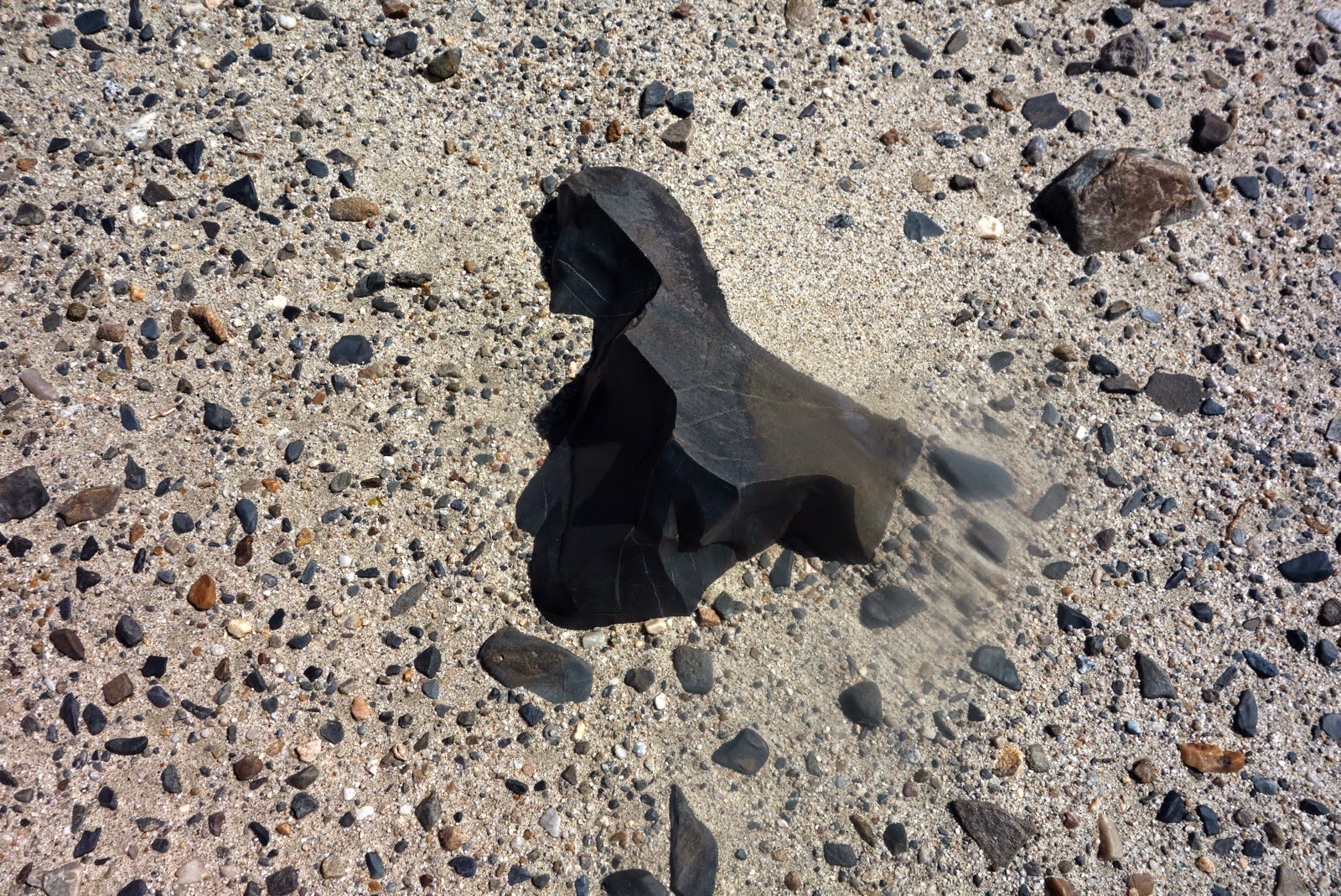
Black sand has a different density so the grains intermingle to create ripple art. (THW, photo)

Standing completely still on the crest of the sand mountain, we were startled by an inexplicable, alien sound--booming sand. The slopes lie at the angle of repose so as wind whips sand over the crest, it glides down, creating an ultra strange vibrational sound. Plunging off the crest, sand avalanched under our feet, booming away, the ground pulsating beneath us. (THW, photo)

Eureka Dunes Campground
There are two clusters of sites, about seven total. Each has a picnic table and shares the outhouse. There is no water. Pack out your trash. Enjoy the remoteness, quietly snuggled at base of the dunes and Last Chance Range, shown. Dramatic and appealing, the dunes positively glow at twilight. (THW, photo)

No comments:
Post a Comment