Travel: From Escalante, UT, travel east on Hwy 12 to MM 66.9. Turn onto a dirt pulloff out of the line of two functioning range gates on the south side of Hwy 12.
Distance and Elevation Gain: 10.1 miles (13.1 with side trip); 2300 feet of climbing
Time: 6:30 - 10:00
Difficulty: Trail, off-trail; navigation challenging; mild exposure
Maps: Tenmile Flat; Calf Creek, UT 7.5 USGS Quads
Reference: Canyoneering 3: Loop Hikes in Utah's Escalante, Steve Allen, 1997. Utah's Canyon Country Place Names, Steve Allen, 2012.
Guest Author: Thomas Holt Ward
Date Hiked: May 22, 2017
History of the Bowington Road: Originally a horse trail established by John Bowington in the early days, it linked Escalante and Boulder. It was later improved to a rough wagon road and enjoyed a brief period of popularity, being favored as less dangerous than the Boulder Mail Trail. It was abandoned after several sections washed out a few years later [paraphrased from Steve Allen].
Quote: Greatness is a road leading toward the unknown. Charles De Gaulle
Hiker ascends an impressive cut sandstone ledge on the BR. (THW, photo)

Route Summary: From TH 5960, cross Hwy 12 and head northeast about a mile to Big Flat Wash. Follow this two more miles and make a steep descent to the Escalante River. Ascend the opposite bank and climb bare slickrock another 1.6 miles generally northeast to meet the Bowington Road. Follow this well-cairned trail another 2.6 miles southeast back to the Escalante River. Optionally, take the three mile round trip to Escalante Bridge. Cross the river and ascend the spectacularly engineered section of the road exiting the river basin. From here, continue across slickrock and Big Flat another three miles to rejoin your incoming path and return to the starting point.

The Hike: From the trailhead at 5,960 feet, cross Hwy 12 and roll under a well built barbed wire fence (don't worry - you're on public land). Walk northeast through rice grass and snake weed on a generally gentle downhill route. A transmission line should appear off to your left at about 0.3 mile. At 0.6 mile, you should arrive at Big Flat Wash amongst piles of cow patties. The wash at this point is mud-walled, but soon to transforms itself into sculptural sandstone. You're in the Carmel Formation at this point, but as you proceed downstream, the wash quickly changes to washed Navajo sandstone. If you're lucky, observe Primsrose Gigantea sprouting from tiny sand dunes.
The first pouroff obstacle can be bypassed easily on the left. A branch enters from the right soon after and the drainage becomes a wonderland of gentle pools and polygonal pillow rock--a route over rippled stone with minor step downs that charm without hindering.
Eventually an impressive 75 foot pouroff blocks the way, but can be bypassed on the right through a stone gully. The canyon is now more broad, decorated with cliffrose between 300 foot walls, and sandy bottomed between tanks (with good water on this occasion).

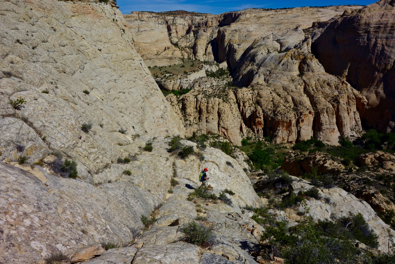
At mile 2.0, all this charm drops 200 feet into a deep impassable gorge. (THW, photo)
 |

Follow this down canyon for a couple of hundred yards until you see a 10 foot pinnacle on top of the slickrock ridge on your right. You can friction your way up the slickrock to the tower, choosing the least steep route you can find--there are lots of good choices.

Once there (mile 2.5), to the northeast is a shallow slickrock basin with a higher ridge beyond. Head for the lowest point on that ridge by whatever route through the dazzling white stone that you like. Reaching that point, the Escalante River valley is visible at last. And to your right is a large crack in the high walls of the river basin. It looks daunting, but this is your way down.

Finding the right spot to descend is not obvious. There is a nice cairn on a bench just below the rim where you are standing about 0.1 or 0.2 mile along the rim toward the crack. Head down from here following occasional cairns and a worn path.

A little ways down, you will come to the top of a bouldery gully. This may be an alternate route down (there's a path to it at the bottom), but a trail also goes left, which is the path we took.

The path moves north along a social trail on edge under the Navajo cliff. Make a steep descent down a friction pitch and join the other path to the river. A more open route instead of the mysterious crack.
The view across the river to the sandstone region to be explored:

Looking back on route down below the Navajo cliff-face:

Congratulations, you've reached the floor of the river canyon at 5,380 feet, a navigational accomplishment. Although the route will remain unmarked until you reach the Bowington Road, you've done the toughest part.
Join the well-trodden backpacker's trail heading right downstream along the river. At mile 3.3, you will cross the river on that trail. A few steps further and you should spot a social trail heading left towards a break in the Navajo sandstone. This is the way out. You will first enter a sand-floored drainage with ponderosa pines.

At the upper (westerly) end, you will see a black streak left by the passage of water down the stone. Walk around a pool and follow this up out of the sand. From here to the Bowington Road, in one of the finest segments of the hike, you will be on slickrock almost exclusively. This begins with a large bowl at a striking reflection pool, which can be bypassed on the right.

You can return to near the center of the drainage at this point and traverse along multiple pools on a bit of a friction pitch, or you can remain high above them until the series of bowls ends. The Navajo walls here are breath-taking and creamy.
This drainage bowl is southeast of Point 6084. You can see a 15 foot pinnacle on the ridge just below that prominence. Head for it.

At mile 4.1 (5,800 feet) you will come to a broad saddle above a northwest-southeast running drainage. The bottom of this drainage looks somewhat appealing, but don't be fooled. It is a nearly impassible tangle of foliage. The correct path is to parallel the drainage heading northwest along the gently sloped slickrock above.

At mile 4.4, you will see the canyon below divides in a section of open rock. This is where you want to cross over and enter the northeast branch. After a series of impressive deep tanks, at mile 4.6 (5,850 feet), you will see a line of cairns crossing the drainage and heading up a sandy hill on the right. You have reached the Bowington Road.

The trail now travels easterly in and out of sand amongst wizened pinons and junipers. To the north, you will see domes and wildly shaped prominences rising out of iconic cross-bedding and pillow rock hills. (THW, photo)

As the trail sweeps to the southeast, a deep wide gorge opens up ahead. This is the fault through which the old road descends back to the river, and a spectacular one it is.

There is complete solitude as you descend through mustard sands and white walls along the southwestern side of the canyon. The twisting path passes a rusty stack of paper-like layers. (THW, photo)
 |

Before you reach that point however, perhaps a hundred feet above the bottom, you should stop and inspect the opposite wall for your way out. Yes, another navigational challenge awaits. There are two notable (if not entirely obvious) landmarks to look for. Almost directly across the canyon, perhaps a little to the right, the actual Bowington Road is visible making a rising traverse from left to right up the sandstone wall. It may not jump out at first, but it is ruler-straight in a land of curves.

Following this line to the left, you will see a distinctive pink pinnacle with a shear face on the left side. The entrance to the rising road is located near the base of this pinnacle. Continuing down, the river is reached at mile 6.9.
Side Trip to Escalante Natural Bridge: At this point, it is possible to make a short but rewarding side trip downstream. The round trip is about three miles on the well-worn Escalante River Trail and includes a skyline arch, fascinating petroglyphs, and the natural bridge (I have not made this trip personally, although I have been there from the trail that runs upstream from the Hwy 12 bridge).
Begin by heading towards the river until you encounter the well-worn backpackers' trail along the river. Turn left downstream and be prepared for multiple wet river crossings. In about a mile, the unnamed skyline arch will appear at the top of the canyon wall on your right. Beyond this, there are elaborate petroglyphs along this wall and a small ruin. Finally, in another few tenths of a mile, the 130 foot tall Escalante bridge appears on your right. Return as you came. (THW, photo)

Continuing the Hike: Walk along the north bank of the river a little downstream of where you entered the canyon. You should find a worn (if steep) crossing point which is most apparent on the opposite bank. You should be very near the aforementioned pink pinnacle, shown.

Cross here and follow a visible trail into a large break in the canyon wall just upstream of a side canyon. You should be able to see the worn path winding up through this break, although there were no cairns here when we visited.
The path climbs up and back towards the river, coming out in the amazing cut you observed from the opposite side.

Signs of construction are obvious and impressive here, with sections of wall hacked or possibly blown out, chiseled steps, holes for supports (for something) and scattered bits of very old dimensional lumber.
After ascending along the river for about a third of a mile, the cut stone path sweeps to the left and away from the river into a large open area of rising slickrock, passing southeast of Point 5769.

After this point, and contrary to some reports, we found only the occasional seemingly random cairn, and it is difficult to know if you are on the old road or not.

Continue southeast through this area, eventually turning more to the south in order to remain in slickrock. If you're lucky, you'll reach a section of more apparent construction remnants where the old road exits the slickrock on a steep friction pitch, image-left.

Once out of the slickrock, we found no further trace of either road or trail, nor any cairns. Steve Allen's description does indicate the possibility of joining an off-road vehicle track, but we were unable to locate this. In this case, proceed by dead reckoning across the benchland until you reach Hwy 12. If you encounter a shallow canyon with cliff walls, this is probably Big Flat Wash upstream of where you entered it at the beginning of the hike. In this case, proceed left along the cliff until you reach an obvious place to head off the mini canyon and cross over. (You have actually found the original BR again, here.) Reaching the highway, you can find your car from there, at about mile 10 (or 13, with the side trip).
An important note from author Steve Allen about protecting endangered National Monuments in Southern Utah.
6 comments:
I know this is a bit old now, but I was wondering if you ever stumbled upon any sites/ruins while up there around big flat? I didn't take note of any in the picture, but always sort of assumed some were around that area tucked away.
Hi Sal, Thanks for your question. We were focused primarily on navigation challenges on this expedition. However, we were casually looking out for cultural sites and didn't see anything prehistoric in the Big Flat area. Debra
What a fantastic hike. So much beautiful white sandstone and some wonderfully intricate route finding. And what an amazing bit of history to follow the Bowington Road, carved into the rock hillside. Thanks for writing about this route, Debra.
This post was clearly intended for you. Good job finding your path through complex terrain. I'm pleased Earthline was helpful. Thanks for your comment. Debra
Hi Debra, I have only recently discovered your blog and am thoroughly enjoying reading your beautifully written trip reports, especially for Southern Utah, where I have spent many enjoyable days hiking and backpacking over the years. I am really looking forward to following a few of your routes at some point in the future. Although I thought I was fairly familiar with this area, you have introduced me to places that I literally hadn't heard of, and am now very interested to explore. I don't want you to reveal all your secrets, but how did you find out about the Bowington Road and Claude V. Cutoff Road, for example? Is there a book somewhere that highlights these old historical roads in the area ?
Hi Lain, I appreciate your enthusiasm for Earthline. I started roaming around solo in the region 30 years ago prior to the inception of GSENM. Many of the Earthline posts reflect early discoveries. More recently, I've been referencing my friend Steve Allen. His Canyoneering 3: Loop Hikes in Utah's Escalante is noted at the top of this post. Bowington and the Claude V. are detailed in Steve's guide. Debra
Post a Comment