Travel: From Interstate-10, take Exit 211, 87 North (Florence and Coolidge). Measure from the signal on the east side of the overpass and drive east toward the Casa Grande Ruins National Monument. Your odometer reading may vary by as much as 5%. AZ-87 is well north of the peak and it's going to feel like you're going in the wrong direction for awhile. At 3.5 miles, turn right on Houser Road. At 8.6 miles, turn right on Brady Pump Road. At 9.8 miles, leave the pavement and angle right on a dirt road just before an industrial complex. The road comes to a Y at 10.2 miles. You can go either way. Both choices will route you back onto a powerline service road. Open and close a gate at 11.7 miles. At 13.1 miles, turn left at a T. From here it is just 0.1 mile to the end of the road. The track is rocky; good tires are essential. 4WD with moderate clearance is recommended. The parking area is on Arizona State Trust Land. Post a recreation permit. You will find several alternate travel instructions on the web. Thank you to Southern Arizona Hiking Club leaders for scoping out this excellent access very near a footbridge over the CAP canal.
Picacho Peak State Park: While you are in the area visit the park (fee) for camping, visitor center, and an ultra fun little peak climb.
Distance and Elevation Gain:
Newman Peak, 5 miles; 2,700 feet of climbing
South Newman, 4.7 miles, 2,450 feet of vertical
Total Time for Either Hike: 4:30 to 6:00
Difficulty: Faint trail and cairned route; navigation moderate; Class 2+ bouldering with no exposure; hike on a cool day (winter months) and carry all the water you will need; wear long pants.
Map: Newman Peak, Arizona 7.5' USGS Quad
Date Hiked: Newman Peak, February 29, 2020; South Newman, December 11, 2020
Quote: And above all, watch with glittering eyes the whole world around you because the greatest secrets are always hidden in the most unlikely places. Those who don't believe in magic will never find it.
Newman Peak is identifiable from the Interstate and from the beginning of the hike by its summit towers, image-left. The path through the sloping Sonoran and near vertical west walls is not immediately apparent. The landscape is complicated by broad washes and narrow defiles that have to be sorted out as you ascend. Peak 4,209', "South Newman", is image-right. (Thomas Holt Ward, photo)

Route: For Newman Peak, following trail remnants and cairns, walk east up the bajada and along a westward waterway. Enter a stone-filled gully and climb north. Break out of the chute and hike east to the summit. Visit the web for an alternate route that approaches from the southeast. For South Newman, leave the Newman trail at one mile and climb southeast up a swale to the South Newman--Point 4,162' saddle. Climb the east ridge of Peak 4,209'.


From trailhead parking at elevation 1,840 feet, walk south on the road paralleling the canal for about 100 feet. Pitch up a single track on your left, hop over a barbed wire fence, and cross the footbridge. In wintertime, morning shadows linger. (THW, photo)

Walk east a few paces and then north while watching for cairns heading due east. The 1930s trail is subtle after decades of erosion, floods, and plant growth. It requires navigation prowess to stay on the old track. Link to Hike Arizona for an historical account of the trail. In 1931, an airway beacon was installed on Newman Peak to assist pilots flying at night. The trail was built for the installation and weekly inspection of the two-ton beacon.

The bajada has a park-status supply of saguaro. Plus, there are barrel, hedgehog, pricklypear, and mammillaria cactus; buckhorn, teddybear, and chainfruit cholla; palo verde, agave, ocotillo, creosote bush, and triangle leaf bursage. The bloomers were just getting started. We noticed brittlebush, Arizona lupine, trailing windmill, ragged rock flower, deervetch, desert globemallow, tackstem, hummingbird bush (chuparosa), scorpionweed, and fiddleneck.

We ran into a few climbers who were going to traverse the ridge between Newman Peak and South Newman and then descend through this draw back to the trail.

Weathered boulders are piled up along the banks of arroyos and on the bajada. Cross the broad and beautiful stony wash at 2,540 feet. At 1.2 miles, pass by a hapless boulder with a white arrow pointing the way to the "top". Steadily the boulders increase in size, the clambering begins, and the pace slows. It is a rock fest from here to the summit.

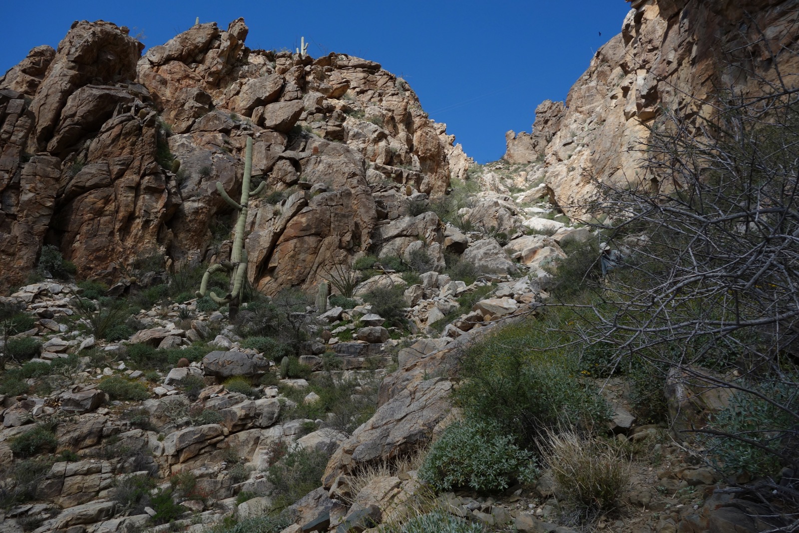
As you ascend toward the west walls you will notice a number of gullies and chutes coming into the main channel from the north. The trail pitches up the defile located just east/right of the round stone knob (left of center in the image below). Notice the wires strung from the peak.

Follow cairns carefully as you transition up-mountain-left toward the climbing chute.

Turn north into the chute at 1.8 miles, 3,460 feet. In 2020, there were plenty of cairns to alert you. Take special note of this location for it is here you must leave the gully on your return.

The toughest part of the hike begins. The terrain steepens and material is loose. Gain 560 vertical feet in less that 0.4 mile. Groups use caution; one member in our party dislodged a boulder three feet in diameter. The old trail is almost nonexistent but some dilapidated retaining walls remain. The pitch is troubled with catclaw, cholla, and hackberry. This image looks down on the lower gully. We spotted a desert bighorn with a lamb in the defile.
(THW, photo)

At 3,800 feet, make a short jog to the west and then turn back north. The image below shows the upper gully from that location. This little jog is barely noticeable on the upclimb but it threw us for a loop momentarily on our descent. Remember this place.

These hikers are in the fun zone in the upper chute. (THW, photo)

I find it troubling that anyone would spray paint the obvious out in the wilderness. (THW, photo)

The gully is constrained by walls of erratic and shaved stone. The group climbing both peaks is about to crest the chute in this image.

Top out of the gully on a small saddle at 2.2 miles, 4,020 feet. The old trail is in better shape in the upper reaches of the mountain. The path does a lateral north-northeast while heading a draw and then climbs east on switchbacks with well-placed stone steps.

This image looks down on the platform at the top of the chute and over to South Newman. Picacho Peak is on the rise and Baboquivari Peak claims landmark status in the south.

Hardware gives away the location of the peak.

Cresting, swing around to see I-10, irrigated fields on the flats, and Table Top Mountain in the northwest.

Arrive on the broad summit at 2.5 miles. It is seriously industrial with three sets of microwave towers, buildings, a helicopter pad and who knows what else. The University of Arizona Ramblers placed the summit register in 1989 and captured records dating to 1988.

Walk all over the crest to take in the boundless vista. The Flatiron in the Superstition Mountains is distinctive to the north. Image-left, the Tortolita Mountains lie in front of Mount Lemmon and Pusch Ridge. The Tucson Mountains and Kitt Peak are in a cluster with Safford Peak. I-10 cruises through the gap. And finally, you can size up whether you'd like to make the push to South Newman or return as you came. I regret not doing the traverse when we climbed South Newman. The day was short and we got a late start. (THW, photo)

With its sheer west escarpment and a summit free of human presence, South Newman radiates strong appeal.

Total Time for Either Hike: 4:30 to 6:00
Difficulty: Faint trail and cairned route; navigation moderate; Class 2+ bouldering with no exposure; hike on a cool day (winter months) and carry all the water you will need; wear long pants.
Map: Newman Peak, Arizona 7.5' USGS Quad
Date Hiked: Newman Peak, February 29, 2020; South Newman, December 11, 2020
Quote: And above all, watch with glittering eyes the whole world around you because the greatest secrets are always hidden in the most unlikely places. Those who don't believe in magic will never find it.
Newman Peak is identifiable from the Interstate and from the beginning of the hike by its summit towers, image-left. The path through the sloping Sonoran and near vertical west walls is not immediately apparent. The landscape is complicated by broad washes and narrow defiles that have to be sorted out as you ascend. Peak 4,209', "South Newman", is image-right. (Thomas Holt Ward, photo)

Route: For Newman Peak, following trail remnants and cairns, walk east up the bajada and along a westward waterway. Enter a stone-filled gully and climb north. Break out of the chute and hike east to the summit. Visit the web for an alternate route that approaches from the southeast. For South Newman, leave the Newman trail at one mile and climb southeast up a swale to the South Newman--Point 4,162' saddle. Climb the east ridge of Peak 4,209'.

The Picacho Mountains are a compact north-south trending range located midway between Tucson and Phoenix. Picacho Peak, 3,370', (image-left) and the Picacho Mountains are separated by a gap of shallowly buried bedrock. Interstate 10, railroad tracks, and the Central Arizona Project canal pass through the opening. Picacho Peak is composed of basalt and andesite volcanic rocks. Newman Peak and South Newman consists of crystalline rocks: granite, gneiss, and schist. (Arizona Geological Survey)

From trailhead parking at elevation 1,840 feet, walk south on the road paralleling the canal for about 100 feet. Pitch up a single track on your left, hop over a barbed wire fence, and cross the footbridge. In wintertime, morning shadows linger. (THW, photo)

Walk east a few paces and then north while watching for cairns heading due east. The 1930s trail is subtle after decades of erosion, floods, and plant growth. It requires navigation prowess to stay on the old track. Link to Hike Arizona for an historical account of the trail. In 1931, an airway beacon was installed on Newman Peak to assist pilots flying at night. The trail was built for the installation and weekly inspection of the two-ton beacon.

The bajada has a park-status supply of saguaro. Plus, there are barrel, hedgehog, pricklypear, and mammillaria cactus; buckhorn, teddybear, and chainfruit cholla; palo verde, agave, ocotillo, creosote bush, and triangle leaf bursage. The bloomers were just getting started. We noticed brittlebush, Arizona lupine, trailing windmill, ragged rock flower, deervetch, desert globemallow, tackstem, hummingbird bush (chuparosa), scorpionweed, and fiddleneck.

We ran into a few climbers who were going to traverse the ridge between Newman Peak and South Newman and then descend through this draw back to the trail.

Weathered boulders are piled up along the banks of arroyos and on the bajada. Cross the broad and beautiful stony wash at 2,540 feet. At 1.2 miles, pass by a hapless boulder with a white arrow pointing the way to the "top". Steadily the boulders increase in size, the clambering begins, and the pace slows. It is a rock fest from here to the summit.

As you ascend toward the west walls you will notice a number of gullies and chutes coming into the main channel from the north. The trail pitches up the defile located just east/right of the round stone knob (left of center in the image below). Notice the wires strung from the peak.

Follow cairns carefully as you transition up-mountain-left toward the climbing chute.

Turn north into the chute at 1.8 miles, 3,460 feet. In 2020, there were plenty of cairns to alert you. Take special note of this location for it is here you must leave the gully on your return.

(THW, photo)

At 3,800 feet, make a short jog to the west and then turn back north. The image below shows the upper gully from that location. This little jog is barely noticeable on the upclimb but it threw us for a loop momentarily on our descent. Remember this place.
These hikers are in the fun zone in the upper chute. (THW, photo)

I find it troubling that anyone would spray paint the obvious out in the wilderness. (THW, photo)

The gully is constrained by walls of erratic and shaved stone. The group climbing both peaks is about to crest the chute in this image.

Top out of the gully on a small saddle at 2.2 miles, 4,020 feet. The old trail is in better shape in the upper reaches of the mountain. The path does a lateral north-northeast while heading a draw and then climbs east on switchbacks with well-placed stone steps.

This image looks down on the platform at the top of the chute and over to South Newman. Picacho Peak is on the rise and Baboquivari Peak claims landmark status in the south.

Hardware gives away the location of the peak.

Cresting, swing around to see I-10, irrigated fields on the flats, and Table Top Mountain in the northwest.

Arrive on the broad summit at 2.5 miles. It is seriously industrial with three sets of microwave towers, buildings, a helicopter pad and who knows what else. The University of Arizona Ramblers placed the summit register in 1989 and captured records dating to 1988.

Walk all over the crest to take in the boundless vista. The Flatiron in the Superstition Mountains is distinctive to the north. Image-left, the Tortolita Mountains lie in front of Mount Lemmon and Pusch Ridge. The Tucson Mountains and Kitt Peak are in a cluster with Safford Peak. I-10 cruises through the gap. And finally, you can size up whether you'd like to make the push to South Newman or return as you came. I regret not doing the traverse when we climbed South Newman. The day was short and we got a late start. (THW, photo)

With its sheer west escarpment and a summit free of human presence, South Newman radiates strong appeal.

South Newman, Peak 4,209'
Begin on the Newman Peak route. At 1.0 mile, 2,420 feet, the Newman trail jags left and the route to South Newman continues straight ahead. In 2020, there was a large cairn, a branch across the path, and a couple of big boulders.
The route is cairned to the saddle but they are infrequent in the lower segment. You could just plow up to the saddle but the cairns make the climb easier and we did our best to follow their guidance. There are fragments of a very faint social trail in the grass.

The ever-present north face of South Newman commands reverence, glowing in early-winter ambience. The stone in the swale is composed of granite and diorite but the South Newman wall is gneiss.

By 2,700 feet the route is a bouldery way. It’s primarily Class 2+. We did some low Class 3 moves, possibly avoidable. The swale turns into a headwall and the pitched route crosses the waterway repeatedly. Stay alert to catclaw and thorny plants.

Break out of the boulder field trough and onto a grassy slope at 3,360 feet. From here, it’s easier going to the saddle, 1.9 miles, 3,660 feet. (THW, photo)

There are no cairns showing the way from the saddle. In brief, climb southwest to a knob at 3,900 feet and then up the east ridge to the peak. The image below was shot from the saddle. The east ridge of South Newman is image-right and the climbing gully to escape the saddle is on the left. Walk toward the cliff, jog left and locate the Class 2+, 80-foot chute.


Crest South Newman at 2.3 miles. Not to diminish Newman Peak (it is tallest after all), South Newman has an entirely wild and wonderful presence. The small summit just feels like a peak should, even if you can’t look directly down the west cliff. There’s a peak register but only two to three groups sign in each year. The image below was taken on the summit. It depicts the traverse from the saddle to the parent peak.

The banded subsidiary peak will reward those to take the 0.1 mile jaunt. Walk on sheets of fractured black gneiss. The little dome sitting at the west end of the Picacho Mountains has the best view of Picacho Peak, the canal, the interstate, and points beyond. You needn’t reclimb South Newman. Just angle northeast back to the east ridge.

1 comment:
Hi there, I'm reaching out to ask your permission to use a photo or two from this post for an area nomination to the BLM. Please contact me at joe_trudeau@tws.org. Thanks!!! Joe Trudeau, The Wilderness Society, Prescott, AZ (928) 800-2472
Post a Comment