Travel: From Durango, drive 41 miles north on US 550. One mile south of Molas Pass, just shy of mile marker 63, turn east at the Andrews Lake sign. It is 0.7 mile to lakeside parking with an outhouse, no water.
Distance and Elevation Gain: 8.9 miles; 2,300 feet of climbing
Total Time: 5:00 to 7:00
Difficulty: Trail, off-trail; navigation moderate; steep slope; Class 2+ scrambling up Point 12,450'; no exposure
Map: Snowdon Peak, Colorado 7.5' USGS Quad
Latest Date Hiked: June 21, 2021
Quote: I devoted myself to simplicity and returned to it all, left that workaday life for this
wisdom of wandering, for this wilderness of rivers-and-mountains clarity. Xie Lingyun (385-433 CE)
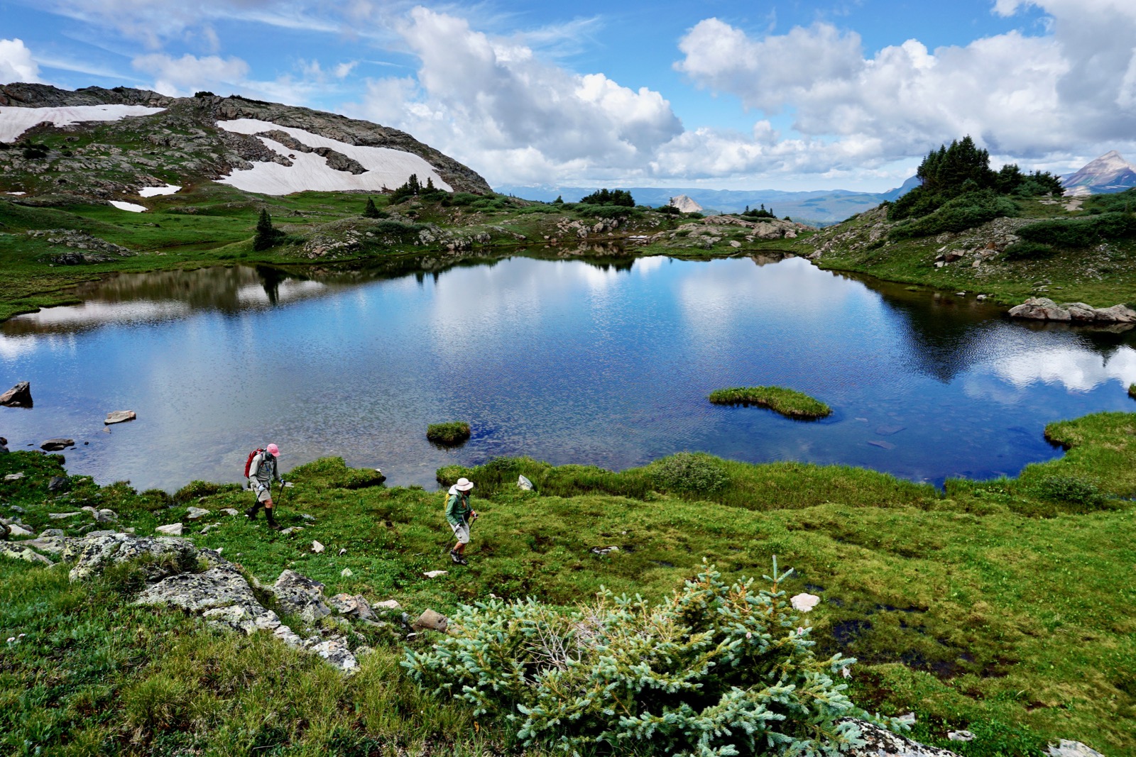
The Snowdon Ponds mirror disks are located on two large benches west of Snowdon Peak in the West Needle Mountains. (Thomas Holt Ward, photo)

Route: From Andrews Lake, hike roughly south on the Crater Lake Trail. Leave the established track and walk east across Snowdon Meadows on a secondary trail heading toward Snowdon Peak. At 11,600 feet, turn south and climb to Heart Lake and on to the saddle east of Point 12,450'. Scramble northwest to the prominence. Loop through Snowdon Ponds and then retrace your steps to Andrews Lake.

Snowdon Meadows
From the parking lot, elevation 10,750 feet, walk across the bridge on the west side of Andrews Lake. The lake is never crowded where throwing in a line is more common than hiking. (THW, photo)

Step up to the right on the engineered, heavily compacted Crater Lake Trail. It switches gently up through deep woods with a diverse array of wildflowers. A trail register at 1.1 miles, 11,200 feet, marks the junction of the main track which heads south to Crater Lake and our spur to the left.
There is much to explore in this moist area and it is the final destination for most hikers. The water in the meadow drains into a swallow hole, or swallet, a limestone geological feature. Karst, a dissolution of limestone, forms rock runners that compartmentalize tundra. A fault created a one billion year gap between the limestone formation and the much older quartzite on the Snowdon ridge. (THW, photo)

Top out on a rim overlooking the first and largest of the Snowdon Meadows. Two paths cross the marsh and rejoin on the other side. The lower track runs beside rills coursing through the tundra, the channels rimmed with marsh marigolds blooming in drifts among verdant mosses. You will be walking on a giant wet sponge. To keep your feet dry, turn left and take the higher track. Below, I am looking at N1 (Point 12,628'), Snowdon Peak, and Point 12,450'. (THW, photo)

This is one of the finest meadowlands in Colorado. Elephant head saturates the landscape with purple spikes. American bistort adds white puffs, and queen’s crown, shown, is a blend of pinks. (THW, photo)

The unofficial and unmaintained trail enters the forest which has been ravaged by beetle kill in the past decade. You just have to put up with stepping over deadfall as the footpath guides you across three more meadows broken by patches of woods. If the trail is indistinct in boggy areas, search it out on the other side. At 2.0 miles the trail kicks up steeply, a warm up for the green wall below Heart Lake. The glistening stone knob and ridge to the south is our highest destination, Point 12,450'.

Point 12,450'
At 2.2 miles, 11,600 feet, the trail splits. The primary track continues straight and climbs very steeply to the saddle north of Snowdon Peak. Our route hangs a right on a secondary track which vanishes in a talus field at the terminal embankment of a rock glacier, image-left. The route crosses the blocks and then climbs the green pitch, shown. Snow remains in the Naked Lady Couloir which is left of the West Buttress of Snowdon Peak.

While crossing the boulder pile listen for pika squeaks and watch for yellow-bellied marmots. Pause and you will hear hidden water running under rock, my favorite sound on earth. If you are not accustomed to walking on boulders, it takes a little practice. It helps to be sure-footed and agile. These wedged blocks are stable and interlocked so try to maintain some momentum while skimming across the field. Caution: quartzite is ultra slippery when wet.
On the other side of the talus yard is the green wall. Climb just west of the beige bedrock slabs. They have been glacially polished and are ice-rink slick. When you reach the top of the slope, turn around and make a mental note of the trail's location leading back into the forest. (THW, photo)

"Heart Lake" is at the top of the green slope at 12,000 feet. (The heart shape is only obvious from Snowdon Peak directly above.) Approach on the east side of the outlet. In 20 years I've never seen the snowfield completely disappear so I call it the Heart Lake Glacier. Cross the outlet on stones, weave through stunted trees for just a few steps and then walk along the lake shore. (THW, photo)

Continue on a southern trajectory taking aim on the saddle east of Point 12,450', shown. This is a superb Snowdon environment, the landscape of ultimate freedom. Treelimit is the highest elevation at which trees can grow. At treelimit they become progressively smaller, more shrubs than trees. Krummholz is a German word which translates "elfin timber" or "crooked wood." The sweet little trees by the lake surrender to tundra, flowers, bedrock and boulders. The visual simplicity is all so appealing. Walk up the fellfield on earthen ramps. Snow lingers long on the north side of the saddle. You may skirt the snow fields on the east.

After a strong winter, water is on the surface and charging under rocks. In 2019, Indian paintbrush and alpine avens were having a good year.

The playful climb to Point 12,450' begins on the south side of the saddle on a green patch at 12,300 feet. Big quartzite boulders on the southeast ridge are great fun. This would be a good Class 2+ scramble for teens or anyone who wants practice before tackling bigger mountains. It is only 150 feet of open climbing to the crest. If this is not your idea of a good time you can still visit the lakes. The prettiest pond is close by south of the saddle.

A peak register tucked in a tall summit cairn awaits at 3.2 miles. Only a few people have signed the register since it was placed in 2016. The prominence is not a ranked summit but it is a stunning place with remarkable views. The biggest drama is to the east. You can feel the Quartzite Dragon (Snowdon Peak) breathing down your back. The distinctive "W" seen from US 550 is in the clef, shown. (THW, photo)

Due north is Molas Lake and Silverton. Above town is Anvil Mountain, image-center, and Grand Turk on the left.
(THW, photo)

There is a full throttle view of the West Needle Mountains, La Plata Mountains, Engineer Mountain, and the Ice Lake group. To capture the image below we walked west along the north edge of the gray stone plateau. With binoculars you could see your vehicle in the Andrews Lake parking lot. The big green patches are the Snowdon Meadows.

Krummholz Tarns
The lakes are located on two glacially carved terraces. As you walk down the west ridge of Point 12,450' you'll get a good look at the lower terrace at 12,000 feet, the "Krummholz Tarns." We spotted almost a dozen lakes and plotted a course to string them together. You are unlikely to see other people as you meander between the shimmering pools. Below, US 550 threads between Potato Hill and Engineer Mountain. (THW, photo)

The lake community offers much to observe: glacially scraped quartzite (rock), mounds of elk scat (fauna), and tiny purple violets (flora). (THW, photo)

Look for brilliant splashes of pink not even a half inch across. Pygmy bitterroot just barely protrudes from the soil.
(THW, photo)

Still air turns pools into mirrors. (THW, photo)

We came upon a deep lake with clear blue water and a stone necklace. At the far end we ascended a green ramp to 12,200 feet, the approximate level of the upper terrace. (THW, photo)

Snowdon Ponds
Turn north-northeast and walk back to the saddle. Along the way you will pass three hanging lakes. It is helpful to follow streamlets uphill because they lead to more ponds and bogs. The liquid mirror near the saddle reflects Engineer Mountain on a still day. Malachite greenness encircles water that matches the color of the sky. (THW, photo)
2 comments:
I visited this beautiful place today. We made a big loop, taking the Crater Lake Trail in for about 2.5 miles, then hiking off-trail to the east for about 1 mile to reach the lakes. Then over the 12,300' pass and back to Andrews Lake.
What a fabulous loop. Nice! Debra
Post a Comment