Travel: In a 4WD low, high-clearance vehicle with tough tires, from Durango drive 47 miles to Silverton on U.S. Route 550. Turn northeast and proceed up Greene Street, the main drag, to the north end of town. Stay straight as San Juan CR 2 veers off to the right. Zero-out your trip meter. Paved San Juan CR 110 (Cement Creek Road), sweeps to the left and starts uphill. You will see a sign for the ski area Silverton Mountain, six miles ahead. Pavement ends at 0.8 mile. At 1.7 miles there is an information board on the left at a pull-out. Look for a road hidden in the trees and easy to miss on the right. Hook sharply right onto CR 70. The sign is visible once you make the turn. In 1.6 miles the road rises 1,300 feet. (Tack this on to your climb if you don't have a suitable vehicle.) At 1.8 miles, take the left fork. Go right at 1.9 miles. The one-vehicle width road has a rocky surface and is the steepest road I've ever been on. Travel through a healthy aspen, fir, and spruce forest. At 3.3 miles, a signed private road comes in on right. Turn left and park on a flat landing with barely room for three vehicles at 11,280 feet. Allow 1:30 from Durango. Use engine breaking to descend this technical road.
Distance and Elevation Gain: 3.4 miles; 2,400 feet of climbing
Time: 3:00 to 5:00
Difficulty: Off-trail; navigation moderate; Class 3 with considerable exposure on fractured, loose rock
Map: Silverton, Colorado 7.5 Quad
Latest Date Hiked: September 5, 2016
Quote: Mountains are not fair or unfair, they are just dangerous. Reinhold Messner.
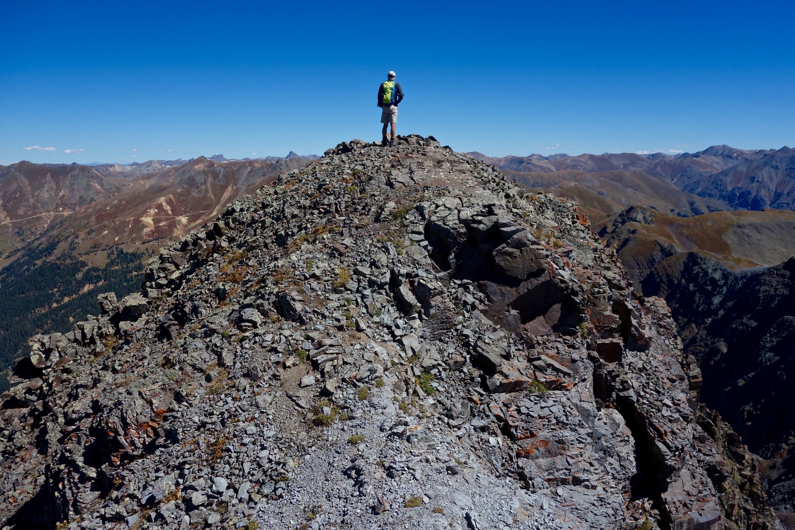
Profile of Storm Peak's southwest climbing ridge.

Route: Climb steeply northeast, staying out of Hancock Gulch. The grade eases at a diamond-shaped platform. Continue on tundra to the southwest ridge of Storm Peak. Round trip to Storm is just under half a mile. Back on the diamond, hike west to Point 13,235' and then south, rejoining the upcoming route above an eroded cliff band.

From the pull-out at elevation 11,280 feet, locate a social trail where the private road and parking spur meet. Use the trail for less than 0.1 mile where it affords a vantage point of the climb. The trail fades away at hunting camps in a group of conifers.

I've ascended the southwest slopes of Storm Peak three times, always differently. Decide on a route that stays to the right of the exposed, eroded cliff band and specifically the substantial outcrop, image-center. There's no getting around the steepness. The last time we headed toward the final stand of conifers at 11,800 feet and then climbed the undulating ridge making use of tundra ledges; this worked beautifully.

It is possible to stay in the tundra for most of the initial climb with a couple of rocky pitches near the top of this lower segment.

Avoid Hancock Gulch, a trap to my right. In this image, Silverton is in the valley, U.S. Route 550 climbs to Molas Pass, and Sultan Mountain, Silverton's guardian peak, is image-right. Storm Peak is visible when driving from Durango to Silverton. (THW, photo)

In just 0.8 mile, reach the top of the eroded cliff band at 12,760 feet. The bucolic slope rises gently from here. Hike northeast along the edge of the diamond-shaped platform for the best views. In 2006, I attempted to climb Storm Peak from Boulder Gulch. After summiting Pt. 13,254' (off image to the right), I encountered the 80 foot wall shown below. It was impossible to scale and the upper reaches of well-armored Hancock Gulch were too precipitous to afford a bypass.

Reach the apex of the diamond at 13,200 feet, 1.2 miles, and turn north. Storm Peak rises into view. It is the moment I love most because of the sharp contrast between the lush, colorful tundra and black volcanic ridge. Velocity Peak, Pt. 13,325', is image-right. (THW, photo)

Walk north to 13,380 feet where the southwest ridge of Storm intersects the diamond at 1.4 miles. From here, it is a mere 0.22 mile to the summit and will take 25 to 45 minutes. There are eight to ten knobs varying between 30 and 80 feet in height. The rock is like shattered glass, riddled with cracks, brittle, and sharp edged. The crumbly stone plays tricks, making the trek tedious and dicey. Test a hold, think it's good, only to have it peel off under weight. The exposure is generally mitigated by a saddle or chute. But in a few places, say, short knife edges and when climbing off the ridge, the exposure is untamed. Be slow and methodical. Stay on the center of the spine but if forced off, bypass north.
(THW, photo)

I led a group up Storm Peak once. Fewer is better.

Following is a sample of images and a description of how we attacked the knobs. These are just illustrative because you'll figure it out as you go. This is the third knob. We went straight up the middle of this near vertical face and then scooted around on the left side for the last eight feet.

My climbing partner is looking down from half way up the third knob. (THW, photo)

Cross a 20 foot-long knife. This is knob number five. We went up the center from the saddle, then moved into the next crack to the right and up the very steep gully. Handholds were good; footholds, untrustworthy.

This is the second half of the ridge.

Here's a look at the last few pitches.

The final wall is the most exposed. We could not climb the slit so we bypassed left of the block covered in yellow lichen and then moved back to the right.

Summit Storm Peak at 1.6 miles. The view from the small, rounded crest is captivating near and far. Find a USGS survey marker and dotted saxifrage.
There is a rift in the summit block making the east ridge traverse to Velocity Peak unlikely.

Looking south, the Grenadier Range accounts for the jagged horizon. Point 13,254' stands above Boulder Gulch. To its right is the 80 foot wall that cut off access to Storm from the south ridge. The cluster of sparkling lakes step down into Boulder Gulch. Across the Animas River is Arrastra Creek and Basin.

The north-northwest ridge of Storm directs to the three Red Mountains. Mount Sneffles wilderness is at skyline.

And finally, across Cement Creek to the west is Anvil Mountain. The Ice Lake cluster with unmistakable Golden Horn is above Anvil. The descent off the initial summit block is the most perilous, sending you slightly off the rib to the north side. Then, cross a short knife.

Back on the diamond, walk west along the undercut north edge. From Pt. 13,235', shown, turn south and intersect the up-coming track above the outcrop. As indicated on the map above, we probed the west slopes for an alternative descent route but penetrating the eroded cliff band did not look promising.

I have climbed Storm Peak in three seasons. In late spring I've glissaded lower slopes. In autumn, geranium leaves flame and flowers have gone to seed except for a variety of gentian and mountain gold. Mid-summer, the assortment and abundance of flowers is exceptional. Look for an albino sky pilot and purple, Silverton wallflower.
No comments:
Post a Comment