Essence: The view of the Grenadier Range from Point 12,891' (Arrow
Benchmark) is so good, to beat it you'd have to go climb the
peaks. Look directly south across the Elk Creek canyon to
the arc of quartzite geometric configurations we call mountains
for lack of a better descriptor. Cover most of the miles on the Whitehead Trail beginning in Deer Park. Arrow Benchmark is a trail and tundra walk. Peak
12,936' is more challenging. The trail begins on a sliver of private land
where hikers are granted an easement. It moves through Bureau of Land
Management property and soon crosses into the Weminuche Wilderness within the
San Juan National Forest. Both peaks are clearly visible from the US 550
overlook on Molas Pass. 2023 Note: LiDAR has elevated unranked Arrow Benchmark by one foot to 12,892' with a rise of 249 feet. Peak 12,936' was elevated to 12,959' with a rise of 395 feet.
Travel: In a vehicle with 4WD low and high clearance, from the
intersection of Greene Street and East 14th Street in Silverton, drive east
three blocks to the bridge over the Animas River. Measure distance from there
and make an immediate right on San Juan CR 33. The track is rocky and very
steep. Pass a wooden box car at 2.2 miles. At the 2.9 mile split in Kendall
Gulch, turn right on CR 33A. The stream is funneled through a culvert under
the road. The track narrows. Shelf segments are protected by trees. Drive
through a meadow and then make a couple of steep, tight switchbacks. The road
splits at 4.9 miles. The tamer choice is straight ahead on CR 33A to a parking
pullout on the left in 0.1 mile. Or, turn right on a technical road requiring
ultra high clearance. Drive 0.1 mile and park on a rise on the right, just shy
of the Montana Mine.
Distance and Elevation Gain: 11.2 miles, 2,300 feet; optional Whitehead Peak adds 2.0 miles and 960 feet
Total Time: 6:00 to 7:30
Difficulty: Trail, off-trail; navigation moderate; mild exposure on Whitehead Trail and moderate exposure on Peak 12,936'
Maps: Silverton; Howardsville; Storm King Peak, Colorado 7.5' USGS Quads
Latest Date Hiked: September 20, 2023
Quote:
Total Time: 6:00 to 7:30
Difficulty: Trail, off-trail; navigation moderate; mild exposure on Whitehead Trail and moderate exposure on Peak 12,936'
Maps: Silverton; Howardsville; Storm King Peak, Colorado 7.5' USGS Quads
Latest Date Hiked: September 20, 2023
Quote:
If there was something in the air
If there was something in the wind
If there was something in the trees or bushes
That could be pronounced and once was
overheard by animals,
Let this Sacred Knowledge be returned to us again.
Atharva Veda
The north faces of Peak 12,936' and Point 12,891' are primitive-looking
volcanic structures. The trail heads deeply incised Whitehead Gulch, freeing
the climber to approach both mountains from welcoming slopes.
(Thomas Holt Ward, photo)

Route: From Deer Park, hike south on the Whitehead Trail. It swings
east around the runout of the west ridge of Whitehead Peak and then tracks
above Whitehead Gulch. Head the gulch and hike south to a pass at 12,560
feet. Leave the trail bearing southwest and climb both peaks in either
order. Return to the pass and rejoin the Whitehead Trail. Climbing Whitehead
Peak is an option discussed at the end of the post.

Whitehead Trail No. 674
The trailhead is located southwest of the large marsh in Deer Park. From the
parking lot for the Montana Mine, walk south on the road a few paces to the
mine, elevation 11,625 feet. The unsigned trail begins to the left of the mine
entrance. A private property sign and chain are strung across the rocky trail.
The sign reads, "No Motor Vehicles Allowed...Hikers & Horsemen Welcome."

The forested portion of this hike lasts mere moments. Walk beside a pretty
little stream and reflection pool in a boggy meadow. This is grouse habitat
but sadly, the fir trees are quickly succumbing to beetles marching across
huge swaths of the San Juan National Forest. Pictured are Peak 13,109' and
Point 12,829'.

Deer Park is a massive U-shaped basin open on the west. In 2010, we did a
seven-summit circuit beginning with Point 13,409' and finishing on Point
12,829'. We hit the Whitehead Trail below Point 12,462'.

Pass below a block field. This 3X4 foot breccia boulder is composed of
cemented angular fragments of igneous rocks ejected by a volcanic blast or
pyroclastic flow.

There has been some effort to keep the pack trail viable. The thin dirt track
is marked with six-foot poles. The path rises very gradually as it moves south
to round Point 12,462'.

At 1.5 miles, cross the wilderness boundary into the Weminuche. This hike's two prominences are visible as well as the Grenadier Range. The West Needle Mountains are remarkably close by, just across the Animas River gorge. From the right is N1, Snowdon Peak, South Snowdon (N2), and N3. (THW, photo)

The trail turns east and holds the contour 1,000 feet above Whitehead Gulch.
Head a ravine below Peak 13,109'.

The thin trail platform is suspended over the drop. It is washed out at about
2.2 miles. The stretch is short but the footing is poor and a slip could send
you sliding down a stone funnel.

In 2023 this passage was somewhat improved.

Southern Colorado is suffering under an "extreme drought" in the summer of
2020 so the little lake on a shelf below Peak 13,109' has almost entirely
evaporated. Yet, it still bears the reflection of Peak 12,936'. (THW, photo)

The pathway threads a line between a verdant marsh at the top of Whitehead
Gulch and steel-gray cliffs on a troubled, narrow ridge. The pack trail is
making for the pass, image-right.


The last 40 feet steepens and footing is slick.


Round the top of the gulch at 3.6 miles. Engineer Mountain stands out in the
westward gap. It's late in the summer now and most of the flowers have gone
to seed. Sneezeweed is hanging on along with bottle gentian, yarrow, and a
smattering of old man of the mountain.

As you approach the pass, the trail braids. Just stay reasonably close to
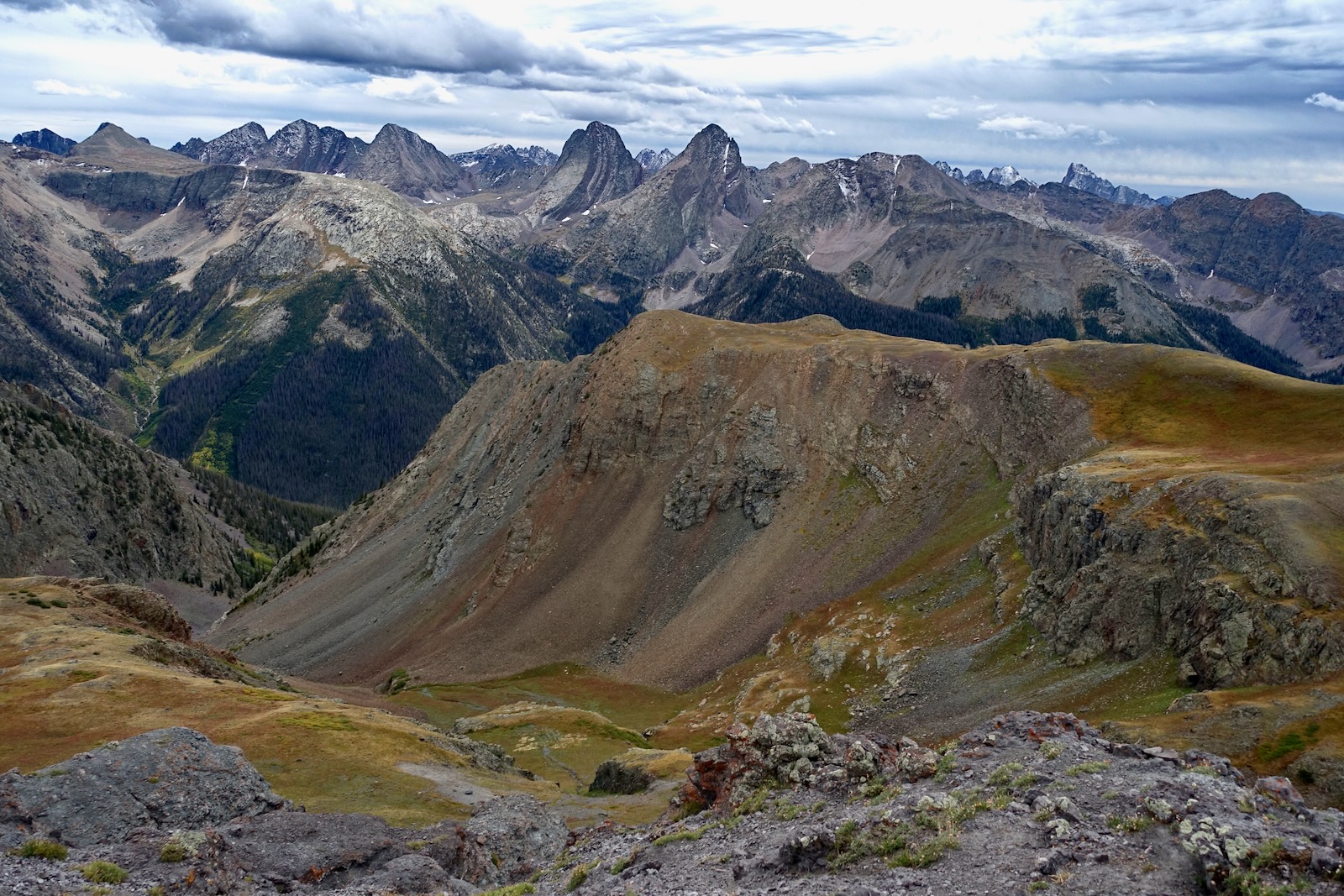
the guide posts. Reach the pass at 4.3 miles, 12,560 feet. Topping any pass
is inevitably a profound pleasure but this one rattles the core definition
of what it means to be human on this planet. We are looking at Wham Ridge on
Vestal Peak, 13,864' (image-center), and Arrow Peak, 13,803'. Various agents
of erosion have scraped and stripped away the sedimentary and volcanic
overburden. What remains are ancient quartzite peaks that are best described
by mathematicians and poets. The humble hiker must resort to quiet
invocations and chants. (THW, photo)

According to the topo, the Whitehead Trail continues east for four miles
passing Lost Lake and Verde Lakes, and terminating at the Continental Divide
Trail. To climb Peak 12,936' (image-right) and Arrow Benchmark, hike
off-trail bearing southwest. I will describe Point 12,891' first because it
is within the capability of most hikers but you could switch the
order.

Arrow Benchmark
A well-trodden deer and elk trail spans from the pass to the saddle
northeast of the prominence. Follow it into the pink quartzite blocks at the
lower end of the east ridge of Peak 12,936'.

Alight on a broad bench. Now the summit is visible and the way is clear. The
strong game trail with hoof depressions will get you across a hardscrabble
ravine. Reach the saddle at 5.2 miles, 12,620 feet.

A small lake is cradled on the terrace to the west. Standing prominently on
the other side of the Animas River is
Grand Turk and Sultan Mountain.
(THW, photo)

The final pitch to the rounded summit is fairly steep but little
hummocks create steps all the way up.

Top out on Point 12,891' at 5.5 miles. The silver-colored benchmark reads
"ARROW ET 1964." If a blog reader knows what "ET" references, please
leave a comment.

The prominence rounds off deceivingly. In one mile the south slope
plummets 3,000 feet to the Colorado Trail running alongside Elk Creek. The
vantage point is ennobling. In the image below, to the right of Arrow Peak
is Electric Peak, Graystone Peak, Point Pun, and Mount Garfield.

The quartzite arc continues east to encompass companion Trinity Peaks.
(THW, photo)

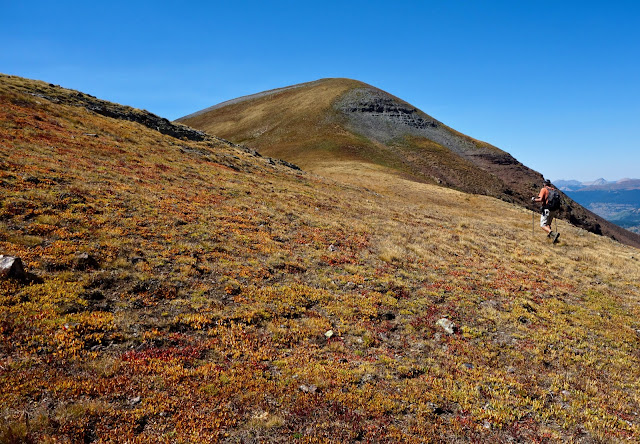
A group descends Arrow Benchmark in golden sublimity. (THW, photo)

Peak 12,936'
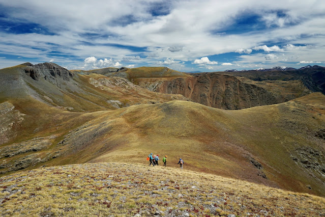
There are two viable routes up Peak 12,936' from the saddle. You could certainly climb the southwest ridge, shown, and descend the east ridge. I preferred the look of the more gradual, grassy pitch to the east ridge, image-right.
There are two viable routes up Peak 12,936' from the saddle. You could certainly climb the southwest ridge, shown, and descend the east ridge. I preferred the look of the more gradual, grassy pitch to the east ridge, image-right.

Once east of the cliffs, we left the game trail and ascended easily on a
pleasant incline to the ridge just 100 feet off the summit, shown.

The ridge is narrow and the material is loose. (THW, photo)

The last 40 feet steepens and footing is slick.

From the top of the final pitch, it is a sweet little undulating walk to the
summit. The peak register was placed earlier this year (missing in 2023). Looking east, the
Whitehead Trail cruises along on the bench above the Elk Creek trench. (THW,
photo)

This image looks west along the extended summit ridge and southwest to Arrow
Benchmark. (THW, photo)

The summit is yet another superlative vantage point on the Weminuche Wilderness.

The descent is straightforward. We down-climbed the east ridge, threaded
between the dark outcrop and quartzite blocks, then strolled down to the
trail at the pass. Reverse this route for the most direct ascent of Peak
12,936'.
(THW, photo)

Whitehead Peak, 13,259', Side Trip
The roundtrip spur adds 2.0 miles with 960 feet of vertical. LiDAR has elevated the unranked summit to 13,276' with a rise of only 139 feet.
Curious about the link
between the Whitehead Trail and Deer Park Trail, we decided to give it a
whirl and climb Whitehead Peak. Looking at the image below, the route climbs
to the small saddle just east of the mountain. There are no cairns at either
portal to this trail and it has largely disappeared. We found scraps of it
here and there. Nevertheless, it is a suitable route if you'd like to get
into the Highland Mary Lakes basin which can be best characterized as
endless bliss.

It was easy enough to just grind up the hill to Whitehead Peak. The Deer
Park Trail no longer exists on either side of the Whitehead--Peak 13,402'
(Mount Rhoda) saddle. In 2004, I did a solo hike from Deer Park. First I
climbed an ultra steep gully to Point 13,399' (not recommended). I went on
to Peak 13,434', Rhoda, Whitehead, and backtracked to the pass. Even in
2004, the trail was absent but I enjoyed the slide down into the,
"...gorgeous high valley, glaciated boulders, stream, and magnificent
flowers." You may also traverse the west ridge of Whitehead and hit the
trail below Point 12,462'. Or, it appears you can drop off the ridge to the
south from the Whitehead--Peak 13,109' saddle. This image looks back at that
descent route.

Peak 12,936' and Arrow Benchmark from Molas Pass, US 550, image-left.

1 comment:
I believe that is a triangulation point for arrow peak (the T in ET). There is at least one more fixed point for arrow triangulation somewhere. Curiously NGS doesn't list this as a station (no PID) and this one doesn't list actual data.
Post a Comment