Essence: The walk to Denver Pass from the west is easy, fast, and high alpine beautiful on abandoned mining tracks. From there, Seigal Mountain is a relatively gentle, welcoming, off-trail climb suitable for families. Effort is minimal and yet the 13er yields a panoramic vista payback. Return by way of Lake 12,536' to see waterfalls spilling into the Horseshoe Creek gorge. Denver Pass provides access to Gravel Mountain and Peak 13,688'. Gravel is a laborious and tedious proposition. The ridge to Peak 13,688' is enjoyable but exposed. Based on new, more accurate measurement technology, LiDAR, the bicentennial has been elevated to 13,702 feet. Our plan was to climb Point 13,708', the north end of the "Catwalk" from Denver Pass, but we were stymied by rain. While there are private holdings throughout this region, the hike is entirely
on public lands administered by the Bureau of Land Management.
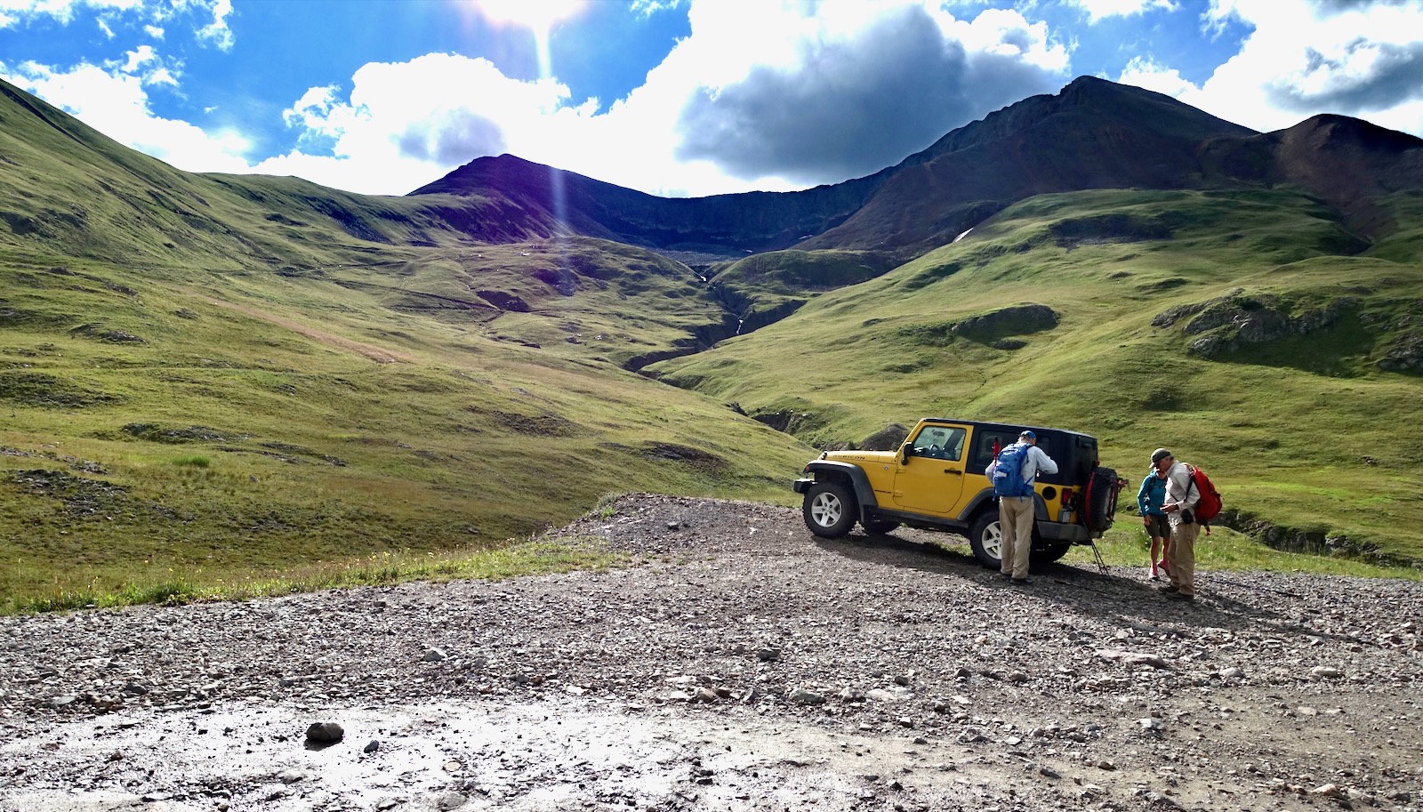
Travel: In a 4WD vehicle with high clearance and sturdy tires, drive up Greene Street in Silverton
to the north end of town. Zero-out your trip meter as you make a soft
right onto San Juan CR 2. The dirt road is good at first but degenerates
to a slow, rocky surface. At 11.4 miles take the signed right fork toward Engineer and Cinnamon passes. When the road to Cinnamon Pass cranks to the right, stay on the road toward Engineer Pass. Park at 13.3 miles on the right, across the road from a shack and just before the turnout for Denver Lake. You can avoid driving over a large bedrock boulder by parking at Denver Bridge and hiking from there. Driving through the ghost town of Animas Forks adds 1.1 miles.
Distance and Elevation Gain: Seigal Mountain and Lake 12,536', 3.5 miles; 1,400 feet. Gravel Mountain and Peak 13,688', add 4.0 miles and 2,400 feet, measured from Denver Pass.
Total Time: 2:00 to 3:30 for Seigal. Add 3:30 to 4:00 for the Gravel pair.
Difficulty: Trail, off-trail; navigation moderate; Class 2; no exposure on Seigal; mild exposure on the ridge between Gravel and Peak 13,688'.
Map: Handies Peak, Colorado 7.5' USGS Quad
Total Time: 2:00 to 3:30 for Seigal. Add 3:30 to 4:00 for the Gravel pair.
Difficulty: Trail, off-trail; navigation moderate; Class 2; no exposure on Seigal; mild exposure on the ridge between Gravel and Peak 13,688'.
Map: Handies Peak, Colorado 7.5' USGS Quad
Date Hiked: August 2, 2022 (Seigal); July 6, 2013 (Gravel and Peak 13,688')
Quote: Hiking is not escapism; it’s realism. The people who choose to spend time outdoors are not running away from anything; we are returning to where we belong. Jennifer Pharr Davis
As seen from Point 13,704', Seigal Mountain has a humble, classic profile when compared with its neighbors. The ease of this climb is a great deal of its charm. (Thomas Holt Ward, photo)

Route: From the parking pullout, walk east on a series of old mining roads to Denver Pass. Climb north to Seigal Mountain. Visit Lake 12,536' on your return. For those going on to Peak 13,688', from Denver Pass descend east into Hurricane Basin and pitch up Gravel Mountain. Peak 13,688' is an out-and-back to the south.

Seigal Mountain is visible (off-image-left) from the parking pullout, elevation 11,900 feet. South of the peak is Denver Pass, Point 13,708', the Catwalk, and informally named Animas Forks Mountain. Please visit Earthline for a description of the Catwalk circuit that includes Wood Mountain.
Walk up the road a few feet and cross the stream flowing from Denver Lake at a culvert. Cut east a few steps to access an old mining track. The west slopes of Seigal are pockmarked with adits and a bevy of criss-crossing roads. There is no best route up the gentle incline. Just aim for the pass either on the zigzag or barge straight up. Turn around to see Denver Lake nestled below Denver Hill (image-right), and Houghton Mountain. The glacial valley of California Gulch is just south of Houghton. The Mountain Queen at the head of the gulch is one of the oldest mines in the western San Juan region. Ore was shipped over Engineer Pass in the 1800s by pack train and wagon to the smelter in Lake City. More recent operations centering around Animas Forks were initiated by World War II and postwar demands for gold, silver, lead, copper, and zinc.

In spite of the lengthy extraction history and the ever-present sound of motos on the Alpine Loop, the basin is an oasis of rolling tundra and wildflower abundance. The deeply incised Horseshoe Creek gorge bifurcates the bowl.

Below, hikers are striding over to check out the lake. Seigal Mountain and the path to Denver Pass are behind them.

We hadn't expected to find a trail to the pass. It was a one-boot-wide footpath but nonetheless an exhilarating discovery.

It is a defining, even imponderable moment to surmount Denver Pass at 1.3 miles and see into a whole new world. Especially this one. San Juan Mountain's highest 14er, Uncompahgre Peak, is locked forever in communion with Wetterhorn Peak, one of the more heart-skipping and unforgiving in Colorado's collection. Inconspicuous between them is one of our all-time favorites, Matterhorn Peak.
Scattered on the 12,900-foot saddle are mining debris, decaying telephone poles and wire. The pass is the launch point for three destinations: Seigal Mountain (north), Gravel and Peak 13,688' (east), and Point 13,708' and its companions (southeast). (Betsey Butler, photo)

Seigal Mountain
It's a mellow ascent for less than 400 feet to the crest. Footing is good, rocks are well seated, there are lots of plant platforms, and it's never too steep. There are occasional faint fragments of social trail.
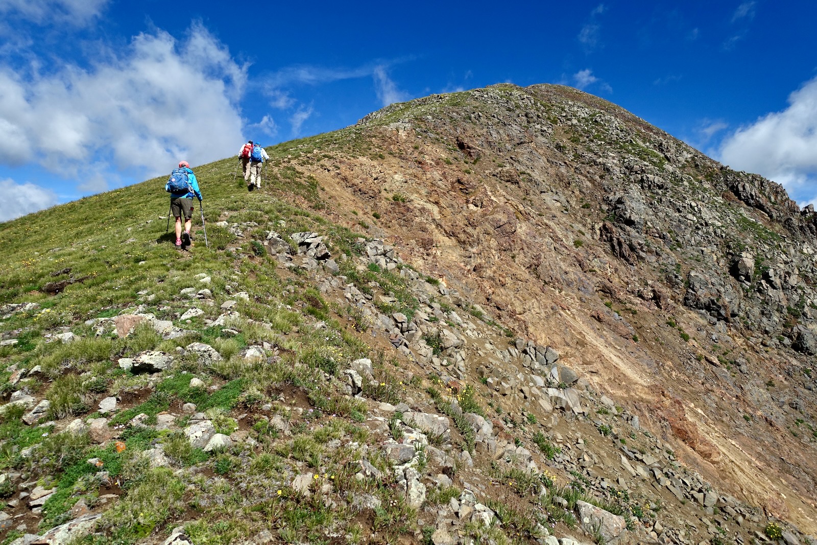
We passed a stick lodged in a rock cairn and I wondered what its story was. We went over three rollers that fooled me every time. Flowers were past peak but we spotted ubiquitous alpine avens, purple fringe, alpine sandwort, bluebell, snowball saxifrage, and moss campion. Below, hikers are approaching the true summit.

Almost there. This image looks down on the sweet little rollers, the glacial cirque holding teal waters, and across to the undeniable fierceness of Animas Forks Mountain. (Richard Butler, photo)

Arrive on the broad, roomy summit after just 1.6 miles. It was such a quick run up Seigal I was bowled over by the first caliber view. Well to the south the quartzite Grenadier Range and Needle Mountains slash the sky.

To the north, beyond the summit plateau and Engineer Pass is Darley Mountain, irresistible Wildhorse Peak, Dragon's Back, and Coxcomb Peak--the odd shaped series. (THW, photo)

Here's another take on the upper echelon peaks to the northeast as seen from Seigal. (Richard Butler, photo)

For those going on to Gravel Mountain (image-left) and Peak 13,688', this is a good vantage point for reconnoitering the route from Denver Pass (image-lower-right) to Hurricane Basin. It looked like a clean shot up Point 13,708' (LiDAR, 13,715 feet, rise 294 feet) but rain was imminent.

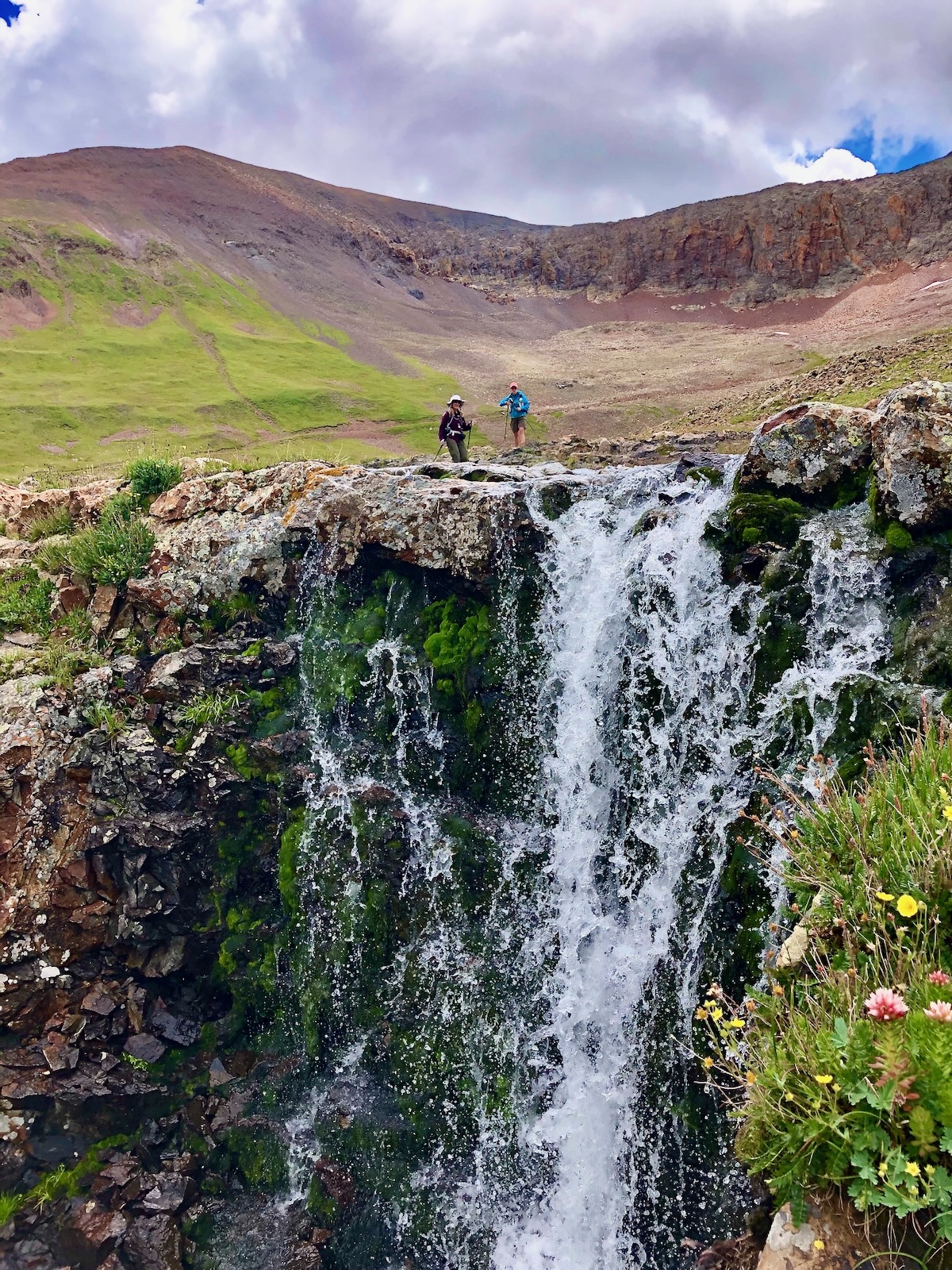
We decided to visit Lake 12,536' as consolation and it turned out to be a delightful diversion. Approaching the lake shore are runs of sparkling volcanic rocks. (Betsey Butler, photo)

The perfectly round lake flows into Horseshoe Creek, the banks lush with thick moss and queen's crown. (Betsey Butler, photo)

The water holds at lake level for a few yards and then plummets into the gorge in a series of waterfalls and cascades. It's a simple matter to rejoin your upcoming track or free range back to your vehicle. (Richard Butler, photo)
Gravel Mountain and Peak 13,688'
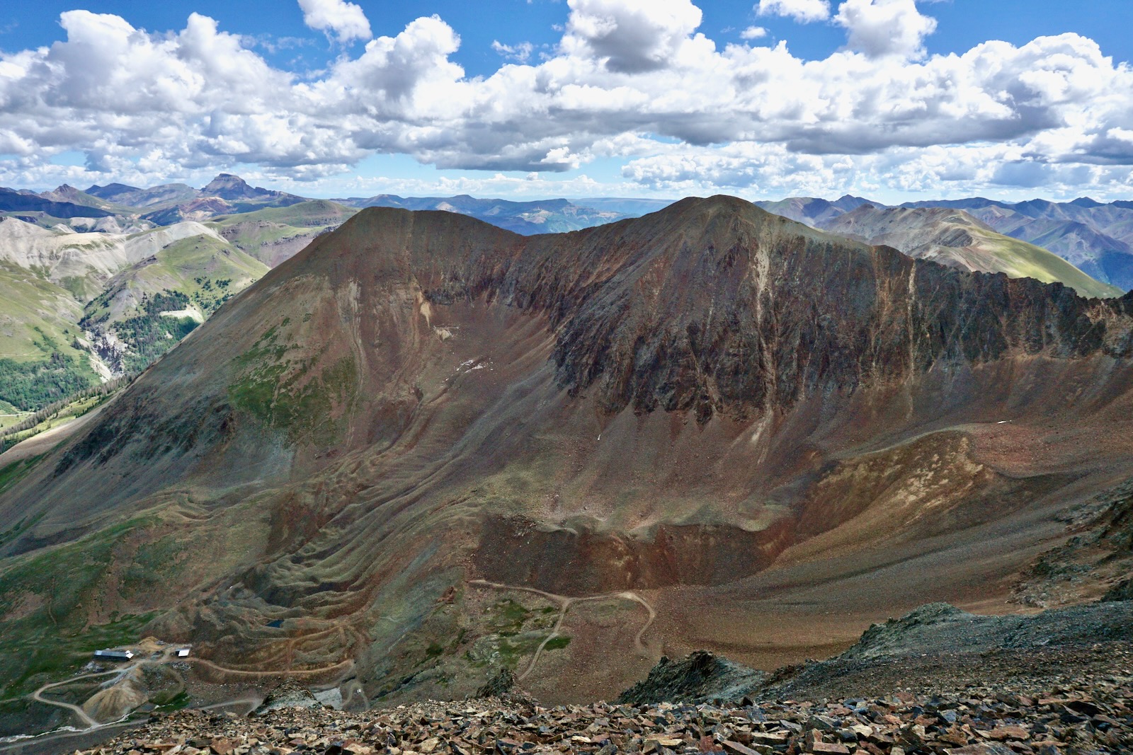
I climbed both peaks on July 6, 2013, a year before I began this Earthline blog. I wasn't carrying a GPS unit but I was keeping field notes and drawing routes on maps. These peaks are close by but they are a significant increase in effort compared with Seigal. The image below was shot from Point 13,708' (on the Catwalk circuit) and shows the boarding house and climbing route. If you are approaching Gravel from Henson Creek, see SummitPost for a description of the east ridge route. (THW, photo)
From Denver Pass we went, "...down a mix of grass, mostly broken rock, 600 feet into Hurricane Basin to
the Golconda Boarding House, elevation 12,300 feet, 0.8 mile. It is a sturdy log structure, very picturesque." Since our visit, in 2014 the Hinsdale County Historical Society stabilized the boarding house and an adjoining compressor/blacksmith building.

It is a 1,300 foot climb over 0.7 mile to Gravel Mountain. I wrote a few choice words (not suitable for this blog) describing the slog up this aptly named peak. "Every step had some slippage backwards on scree. It was rather miserable but I was stoic." Gravel is an unranked summit with 157 feet of prominence. It initiates the tamer of two possible approaches to Peak 13,688'.

To reach the bicentennial, descend to the 13,420-foot saddle. "It was easy and fun to the ranked summit. However, it is quite narrow and one must be mindful." It took us 30 minutes to cover the half mile traverse. On Lists of John, the LiDAR measurement for the peak is 13,702 feet with a rise of 348 feet.

From our perspective on the mountain that day, the south ridge traverse to Wood Mountain looked dangerous and I penciled an "X" on my map. However, the passage across the arête is beautifully described in Liba Kopeckova's SummitPost entry. She concurs with Robert Ormes that it is loose third or fourth class rock. Below, the spiky ridge is seen from the saddle west of Wood. Peak 13,688' is center-left. (THW, photo)

Here's a look at the east side of the south ridge of Peak 13,688' (shot from Wood Mountain). (THW, photo)

We essentially retraced steps by returning to Gravel, sliding back down the west slope, and hoofing it back up to Denver Pass.

No comments:
Post a Comment