Essence: Point 6,820' is on the divide between Finger Rock and Pontatoc canyons, midway between Linda Vista Saddle and "Little Kimball." The tumbled stone prominence has been informally called "Gorp Peak" by generations of hikers but the derivation is lost to history. With a rise of 160 feet, it is not a legal summit. However, given its prominent appearance, important location on the Catalina Front, and far-reaching views, it feels like a real mountain. This approach uses the Finger Rock Trail for most of the distance. With only 1.6 miles off-trail (roundtrip), it's a handy summit. The pitch from Linda Vista Saddle is fairly steep. The only thing that stood in our way were impeding grasses. This hike is within the Pusch Ridge Wilderness, managed by the Coronado National Forest.
Travel: From Tucson's Skyline Drive, go north one mile on Alvernon Way to the Richard McKee Finger Rock Trailhead. Park in a large lot on the left. There is a drinking faucet but no other facilities.
Distance and Elevation Gain: 7.8 miles; 3,800 feet
Total Time: 6:00 to 8:00
Difficulty: Trail, off-trail; navigation easy; Class 2+ with mild exposure on the Finger Rock Trail
Map: Tucson North, AZ 7.5' USGS Quad
Date Hiked: November 17, 2022
Pusch Ridge Wilderness Bighorn Sheep Closure: It is prohibited to
travel more than 400 feet off designated Forest Service trails from
January 1 through April 30, bighorn sheep lambing season. Gorp Peak is off-limits during that time period. No dogs!
Quote: The farther one gets into the wilderness, the greater is the attraction of its lonely freedom. Theodore Roosevelt
The west-facing cliffs of Gorp Peak are highlighted from Point 5,730' on "Linda Vista Ridge," the divide comprising the southeast wall of Finger Rock Canyon.
Quote: The farther one gets into the wilderness, the greater is the attraction of its lonely freedom. Theodore Roosevelt
The west-facing cliffs of Gorp Peak are highlighted from Point 5,730' on "Linda Vista Ridge," the divide comprising the southeast wall of Finger Rock Canyon.

Route: Hike northeast on the Finger Rock Trail to Linda Vista. Stay on the trail toward Mount Kimball another quarter mile. Take a spur south to Linda Vista Saddle. Pitch northeast off-trail to Gorp Peak. Return as you came. Or, as of 2025, descend on the extended Pontatoc Trail from Linda Vista Saddle. See the end of this post for details and a map.

Gorp Peak might well be considered an obscure summit living in the shadow of popular Mount Kimball and Finger Rock Guard. I assume hikers reading this post are familiar with the Finger Rock Trail, the quickest access to Mount Kimball.
The Pima, Finger Rock, and Pontatoc canyon trails all crash down from the high country to the desert floor with a southwestern slant. Finger Rock has a reputation for being the most challenging--relentlessly steep with boulders in the treadway. It's also the most open of the major front range corridors offering expansive views.
Finger Rock Trailhead, elevation 3,060 feet, is one block up Alvernon Way from the parking lot. Leave the city behind and step into the wilderness. Plants weren't flowering in mid-November but we were immediately in the company of familiars: mesquite, barrel cactus, staghorn cholla, jojoba, paloverde, ocotillo, pricklypear, bursage, and saguaro, the signature plant of the Sonoran Desert.
At 0.1 mile the Pontatoc Trail branches off to
the right. Stay on the Finger Rock Trail and take in the sweep of peaks: Prominent Point, Finger Rock and Guard, Mount Kimball, Linda Vista Ridge, Gorp Peak, and Pontatoc Ridge.

The trail tracks along the Finger Rock Canyon channel. The first creek crossing at 0.9 was a study in transformation. The stone-dry streamway was scoured and scrubbed white, the brush obliterated by the 2022 summer monsoons. The trail was wildly disorganized; follow the cairns. Not far to the southeast, Sabino Creek crested during the monsoons at 4,150 cubic feet per second. Just try to imagine that!

At 1.2 miles, the trail leaves the waterway and begins stair stepping on a rising traverse up the high-angled
southeast slope. In moments, the path was far off the canyon floor and the relief was so profound it felt like our foreheads were about to bump right into Finger Rock Guard.

Finer Rock Canyon is a narrow corridor and the trail is caught in the squeeze. The footpath is cleaved under the west cliffs of Point 5,730'. It is little more than a route with rock steps thrown in. We passed gratefully by an AmeriCorps trail maintenance crew trimming brush and shoring up the eroded trail. Look off in the distance and the trail, thin by necessity and obscured by grasses, is difficult to locate. In the lower right corner of the image below a woman in red is passing by a large boulder.

I've been hiking on the Finger Rock Trail for 20 years and consistently my favorite feature is a series of Catalina gneiss sidewalks below Linda Vista. Some hikers will feel a sense of exposure on the stone runners clinging to the very edge of the abyss. (Thomas Holt Ward, photo)

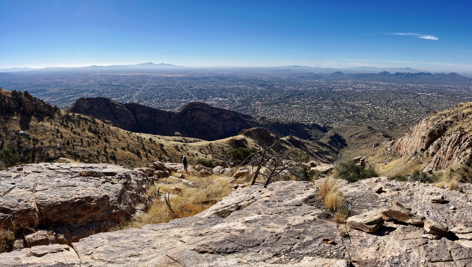
Arrive at Linda Vista at 2.7 miles, 5,220 feet. This is an irresistible place to rest on sitting rocks and look out over Baboquivari Peak, Kitt Peak, and the Tucson Mountains. The 400-foot-tall sheer wall of Point 4,625' creates a grand entrance to Finger Rock Canyon. (THW, photo)

Linda Vista resides at the junction of opportunity. The route to Finger Rock Guard being the most exhilarating and sensational.

For Gorp Peak, stay on the trail toward Mount Kimball. There's a moment where you can actually see beyond the sheer wall of the false summit to the true highpoint.

The length of the southwest ridge is visible from the trail. The Bighorn Fire swept through the region in summer, 2020. Its spotty nature burned many trailside trees while leaving others untouched. (THW, photo)

Leave the primary trail at the apex of the second switchback, 0.3 mile beyond Linda Vista. A strong social trail bears south to Linda Vista Saddle, 3.1 miles, 5,580 feet. From the divide between Finger Rock and Pontatoc canyons, the view opens to Mount Wrightson and the Rincon Mountains. The prominent knob to the west is the terminus of Linda Vista Ridge. Please link to that post if you'd like to tack on the sweet little climb up the stone block.


Gorp Peak is 0.8 mile northeast with another 1,240 feet of climbing. Allow a solid hour or even more each way. The false summit, shown, is just 120 feet below the top.

A variety of waist-tall grasses were the defining feature of the climb in November, 2022. It took considerable extra power to plow up and through the entangling thick mats. Poles were helpful. I don't know if the grasses were opportunists capitalizing on the Bighorn Fire or responding to the 2022 monsoons. It was impossible to see our feet and we were counting on sleepy snakes. Stealth pricklypear and shindaggers were easy enough to dodge. (THW, photo)

A variety of waist-tall grasses were the defining feature of the climb in November, 2022. It took considerable extra power to plow up and through the entangling thick mats. Poles were helpful. I don't know if the grasses were opportunists capitalizing on the Bighorn Fire or responding to the 2022 monsoons. It was impossible to see our feet and we were counting on sleepy snakes. Stealth pricklypear and shindaggers were easy enough to dodge. (THW, photo)

The ridge undulates but overall, the ascent is steep. It's well out of the standard comfort zone--1,000 feet of gain per mile. The image below puts the stone knob into perspective relative to Point 5,730' on Linda Vista Ridge. (THW, photo)

There are no serious challenges or obstacles. Enjoy the Class 2+ scramble up the first minor cliffband or swerve around it with a zig and a zag. Pass through some unspectacular hoodoos in their optimal Catalina zone at 5,800 feet.

Quartz veins within the mass of granitic gneiss have pegmatite clusters with
chunks of mica and feldspar. I happened upon a sizable piece of blue quartz embedded in a boulder. That was a first. Its luminosity was dazzling.

From a rock outcrop we could see the interior ridge straddling the two canyons of Pontatoc. In 2016, we descended on that route after exploring Linda Vista Ridge. On a separate hike we investigated the length of lower Pontatoc Ridge below the 5,140-foot saddle. (THW, photo)
A brief interlude of resurrection moss interlaced on a bedrock sheet was a significant reprieve from boot-snaring grass.

One of the finest features of the upper Finger Rock Trail are the crenelations on the southeast wall. We intentionally walked along the rim above them. Mount Kimball is image-center at skyline.

The pitch up the false summit looks intimidating from afar but it is a non-issue.

From the false summit, 6,700 feet, the view of the crest remains elusive. Madrone, oak, and piñon present more of a barrier but there are no true obstacles.

Emerge from the trees on Gorp Peak at 3.9 miles. The summit has two boulder stacks almost identical in height. There was a small pile of stones and a damaged peak register (with just one signature) on the southeast block. The view is big and broad expanding out from Tucson to the ranges southward. (THW, photo)

Gain a whole new perspective on Pusch Ridge. I was surprised to see that we were higher than both Prominent Point and Table Mountain. They are much bigger efforts. (And therefore deserve to be taller, right?)

The ridge continues, dropping 160 feet and then climbing past the "Towers of Hercules" to Point 7,123', informally called Little Kimball. (THW, photo)

Gorp Peak first grabbed our attention when we were doing a loop that incorporated upper Pontatoc Ridge and Little Kimball. We gave some thought to cutting a spur to Gorp but we had the challenging Towers in front of us. Plus, the jaunt to Gorp looked oppressively brushy in 2016, shown.

The steep descent was a grass slip and slide. It took some effort to stay upright.

I adore the walk down the Finger Rock Trail in the afternoon. Soothing winter warmth. Glowing golden grasses and sparkling rocks. The peaceful, silent desert. It is a deep privilege to step into what feels like truly remote wilderness at the very gates of the city. (THW, photo)

In February, 2025, the Coronado National Forest redirected and extended the Pontatoc Trail system. The upper Pontatoc Trail links with the Finger Rock Trail near Linda Vista Saddle creating the potential for a 7.0 mile loop with 2,600 feet of elevation gain. The instantly popular circuit highlights two radically contrasting landscapes. The Finger Rock Trail, confined within a constricted canyon, is steep and notorious for its boulder-cluttered platform. The spectacular upper two miles of the new Pontatoc Trail is a buff dirt footpath with a carefully managed grade. The old Pontatoc Canyon Trail appears to have been abandoned above elevation 4,360 feet. The Pontatoc Ridge Trail has been renamed the Garnet Trail.

1 comment:
Brava MS D for another wonderful explication!!
Post a Comment