Travel: In Silverton drive up Greene Street, the main drag, to the north end of town. Zero-out your trip meter as you make a soft right onto San Juan CR 2. On a good dirt road drive to the mining ghost town of Eureka where the road crosses the Animas River at 7.8 miles. Look for a sharp left at 8.2 miles rising above the old Eureka Mill foundations. This is Eureka Gulch 4WD road, the first left after the bridge. The narrow but fairly smooth shelf road clings to the south skirts of Eureka Mountain. The track curves around and follows above the South Fork of the Animas River. Pass a private road at a green gate at 9.0 miles. At 9.3 miles, make a soft left onto a thin, rocky road, HC helpful. Park at a campsite below a tailings pile at 9.8 miles. This is shortly before the road crosses the Eureka Gulch drainage. Allow 20 to 30 minutes from Silverton.
Distance and Elevation Gain: 5.7 miles; 3,100 feet of climbing
Time: 4:30 to 6:00
Difficulty: Primarily off-trail; navigation moderate; low Class 3 with moderate exposure
Maps: Handies Peak; Howardsville, Colorado 7.5 USGS Quads
Latest Date Hiked: August 9, 2017
Quote: Each blade of grass has its spot on earth whence it draws its life, its strength; and so is man rooted to the land from which he draws his faith together with his life. Joseph Conrad, Lord Jim
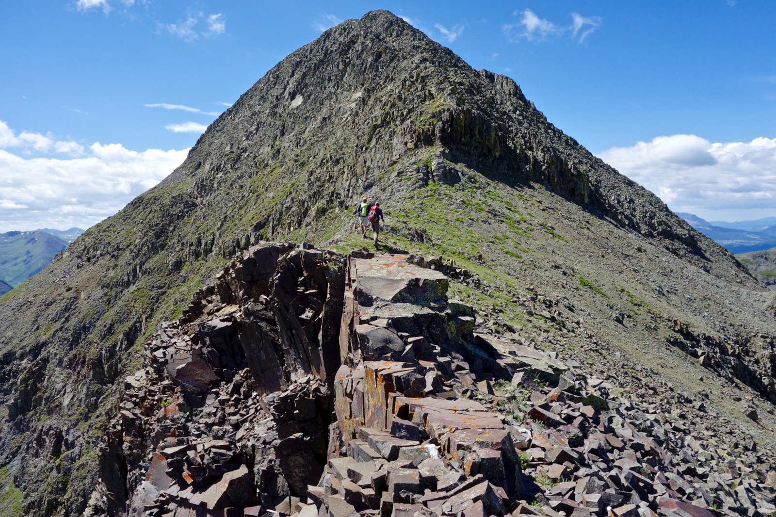
Dome Mountain is the resplendent mid-way point of a grass-covered ridge running northeast from Tower Mountain to Point 12,420'. The massif is bounded by the South Fork of the Animas River on the north and the Animas River, 3,500 feet below to the south. (THW, photo)

Route: There are numerous, pleasant routes to and from Dome Mountain. The black-line route is my favorite because it gains the ridge at first opportunity and then circles the basin above Lake 11,820'. Utilize a slide path to access the northwest ridge of Point 12,420'. Walk southwest to Dome Mountain. Descend on the north ridge to Lake 11,820'. From there do a lateral traverse back to the up-coming route. Alternative routes will be discussed. The blue-line west ridge route is for experienced mountaineers only.

From the trailhead at elevation 10,500 feet, walk west on the 4WD track. It bends north and crosses Eureka Gulch at 0.15 mile. Balance on rickety logs. Dome Mountain comes into view, image-left. The peak in the center is Point 13,321'.

Pass by substantial mining structures. At 0.3 mile, there is a small campsite and vehicle turnaround. Hang a sharp right on the road. Walk up a few paces and look for a pack trail on the left with a sign post placed by the BLM. Locating this trail is a major assist. The image below was taken on the return.

At 0.5 mile, notice a well-worn footpath on the south side of the South Fork of the Animas River. The unstable crossing on thin, rolling logs would be difficult in high flow.

Walk west below a north-facing slope distinctive for intervals of wide avalanche paths. The trail passes through a forest of chest-high trees. These short little guys are buried under snow in the winter protecting them from slides. At 0.8 mile, 10,880 feet, leave the trail and climb the left side of the slide path seen below.
Alternative Routes to Dome: I have continued on the footpath another 0.2 mile or so and climbed the next avi path. From there, I have ascended the northwest ridge of Point 12,540'. Another time, I went to the lake. From there I climbed the green wall heading the basin to Point 12,641'. These routes are indicated on the map above in purple. They work great but you'll miss Point 12,420' and a portion of the ridge.

After about 200 vertical feet an old trail becomes apparent switchbacking up the slide path, staying northeast of a sizable ravine. Perhaps this useful thread was once a mining trail. At 11,400 feet the terrain opens and the desired ridge is visible, image-left. The ubiquitous wildflower contrasting markedly with green lusciousness is orange sneezeweed. Move left and gain the ridge at 1.3 miles, 11,800 feet. From this vantage point, it becomes obvious that the forest all around is dying from beetle kill. This has occurred quite recently and we are heartsick.

Crest Point 12,420' after a consistent, no-nonsense effort at 1.7 miles. The vantage point yields a wonderful perspective. The ridge drops sharply away to the northeast. On the south side the land crashes down 2,600 feet to the Animas River. Southwest, the rollers on the climbing ridge rise ever onward toward the peak. This little knob is not to be missed.

From here the course offers a temporary reprieve from steep climbing. A game trail skirts south of Points 12,540' and 12,641'.

I have seen two elk herds migrate from the lake over the ridgetop and down into Otto Gulch. Keep watch for soaring golden eagles.

Drop into Dome's shallow east saddle at 2.5 miles, 12,540 feet, shown. The tundra pitches up to almost 13,000 feet where loose, rubbly scree overcomes. It's just steep and unstable enough to be a little sketchy to the junction with the north ridge at 13,140 feet. Allow 15 to 20 minutes from here to the top.

The summit block initiates at a six foot, low Class 3 pitch which these hikers are approaching.
The ridge is quite thin but gives you climbing options. Watch for unreliable holds and loose material mixed with well-seated, solid rock. The mountain falls away on both sides, exposure is moderate. Be deliberate. (THW, photo)

Crest Dome Mountain at 3.0 miles. The lookout is outstanding. The image below depicts much of the climbing ridge. On the northeast horizon are Coxcomb Peak, Wetterhorn Peak, and Handies Peak.

Nearby to the west are three lakes encased in step-down Cataract Basin. Macomber Peak is image center and Tower Mountain is on the right. While Tower is the western terminus of this ridge the way is blocked east of Point 13,321'. Every time I've been on Dome the weather has limited top-time. There is so much more to see.

Two hikers downclimb from the summit.

The north ridge intersects just 0.2 mile below the crest. This great little ridge steps down on a mix of crumbly San Juan explosive volcanics and tundra.

Descending the north ridge makes for a wonderful top-of-the-basin loop. (THW, photo)

Descend to the little teal-colored lake at 11,820 feet, 3.9 miles. This image shows some of the headwall climb from the lake to Point 12,641'.

Yellow and green reflected.

Once in electric weather I bypassed the lake and stayed on the north ridge into the trees and down to the footpath beside the South Fork. We encountered a bear with two cubs. Another time, I descended an avi path east of the lake outlet. This time, as indicated by the black-line route, we took a lateral course utilizing elk trails for 0.6 mile back to the upcoming avi path.

Returning to the South Fork.

West Ridge Descent Route
In 2009, I explored the west ridge. From my field notes: It looks impossible but there is a way. Loose. Not too scary. Poles helpful. Point 13,321' is inaccessible from the 12,700 foot saddle. Slide down scree to the north. Descend upper gully into cliffs. Work laterally. Find steep, vegetated slot through cliffs. There is pyrite and rhodonite at the mines on the South Fork. Cross the river and take the pack trail back to the vehicles.
6 comments:
Beautiful!!
Thank you. So very green that day.
BREATH TAKING. My dad owns just shy of 10 acres of land on the cataract basin in Howardsville. For Prospectors it's like heaven full of Gems.💎 We own a good portion of the lakes. Gold and silver can be found as well.
I am pleased you enjoyed reading the Dome Mountain post. It is an honor to hear from a local. Debra
Hi Debra! Can you share a bit more on the blockage issue from Dome to Tower you mentioned? At point 13,321 just East, is it cliffed out or something else?
Excellent question. I've been up Dome three times. In 2009, I was there with a couple of mountaineers who attempted the traverse to Tower. East of Point 13,321' they were turned back by "spires, gashes, and cliffs." Debra
Post a Comment