Essence: Yoas Mountain is on the rippling northwestern flank of the Santa Rita Mountains. The ranked peak is so low it would be inconsequential were it not for its unique vantage point on Elephant Head and other much higher summits on the west slope of the range. This description of the "slightly fun little peak" begins from the Quantrell Mine Trailhead (also the Elephant Head trailhead) and descends 950 feet before starting the 800-foot summit ascent. The trailhead is at a higher elevation than the peak. There are other shorter routes but this one is not difficult and it isn't too brushy if you stay on course. Strong hikers could conceivably combine Yoas with Peak 4,259' and/or Elephant Head and Little Elephant Head. The hike is on public lands managed by Coronado National Forest.
Travel: From Tucson, drive south on I-19 passing the town of Green Valley. Take
Exit 56, Canoa Road. Start measuring from the bottom of the ramp. In
the rotary, go around and under the freeway. At the stop sign turn south
on the frontage road. At 3.2 miles, turn left on Elephant Head Road.
Turn right on paved Mount Hopkins Road at 4.7 miles. At 10.3 miles, go left on
FSR 183. 2WD vehicles with decent clearance should be adequate on the
graded gravel road. Park under a large oak in a circular lot 12.7 miles
from the interstate.
Distance and Elevation Gain: 7.4 miles; 1,850 feet
Total Time: 4:00 to 5:30
Difficulty: Trail, off-trail; navigation moderate; Class 2 with no exposure
Map: Mt. Hopkins, AZ 7.5' USGS Quad
Date Hiked: November 22, 2024
Poem:
What point of light
& dark do we not
understand?
The morning makes
No judgment
Under blue skies
Everything shines.
Art Goodtimes
Seen from the north ridge of Devils Cash Box, our mountains of interest are iridescent in horizontal light. Yoas Mountain is the symmetrical summit on the left. The blip between it and Elephant Head is Peak 4,259'. Little Elephant Head is on the right.
Route: From the trailhead in Agua Caliente Canyon hike generally north on the Quantrell Mine Trail. In one mile, transition northwest and drop into Chino Basin. At the junction with a secondary track, elevation 3,760 feet, walk south for 0.1 mile. Leave the road and ascend off-trail, bearing west-southwest to the summit.
Walk a few paces back down the access road and locate the Quantrell Mine Trail, Forest Service Trail 950, on the north side of the track, elevation 4,580 feet. The trail is open to mountain bikes but I have not seen tracks. The recommended 30-mile loop begins at the Lawrence Whipple Observatory Visitor Center and utilizes rough jeep roads.
The trail
crosses Agua Caliente Canyon right away then bears northwest, rising gently. Mesquite, turpentine bush, agave, shindagger, cholla, and sotol grow
in the desert grassland ecosystem. For better or for worse (off-trail), this is an ocotillo-rich hike. Look southwest to see the deeply cleaved ridgeline bearing ranked summits Peak 5,012' (image-left) and Devils Cash Box, 4,964'. We found them so enticing, we returned a couple of weeks later and climbed those two, along with our favorite, Devils Throne, Peak 5,359' (further south, off-image).
Elephant Head comes into view from a low saddle at 0.7 mile, 4,700 feet, the high point of this hike. Right on the saddle is a trail bearing west and then north to Peak 5,139', "Little Elephant Head." From the saddle, the footpath
gives up considerable ground as it drops into Chino Basin. Be on alert if you hope to catch a glimpse of Yoas along this stretch. Below, it's in the center of the image, down low.
Arrive at a signed junction at 1.0 mile, 4,520 feet. The Quantrell Mine Trail and the route to Elephant Head bears right. For Yoas Mountain, branch left, dropping into Chino Basin.
The thin and rocky crushed granite trail is clearly underutilized. There is grass in the pathway and encroaching from the sides. The visuals of the north face of Little Elephant Head highlight this segment. (Thomas Holt Ward, photo)
Just past the spring marked on the topo (which I did not see) is the Elephant Head Mill Site at 1.7 miles. According to the placard the mill was established in 1915 to process lead, zinc, and silver ore.
We didn't see much evidence of the handful of structures once on the site. The vegetation was too intimidating to poke around for a better look. In this photo you can make out the cement dam and pipes going into a steel tank.
Just beyond the mill site walk through a gate designed to block vehicles but not hikers, bikers, or stock.
Below the gate the trail turns into an overgrown two-track, Chino Spring Road, FSR 4073. The road was too rocky to be pleasant for bikes but I saw occasional OHV tracks. This image looks back on the barrier fall in Chino Canyon and the abandoned road platform leading from the mill site.
The topography was alluring and beautiful with Elephant Head on our right and Peak 4,259' out in front of us. It would be easy to confuse this ranked summit (rise 399 feet) with Yoas. I think the two of them would combine nicely. As it happens, our hiking buddy had a scheduling constraint so we had to let it go.
Yoas Mountain is southwest of Peak 4,259'. Below, the actual summit is to the right of the rocky knob we'll be climbing.
The most dramatic take on Little Elephant Head is right from Chino Spring Road. That is one powerful monolithic pinnacle. (THW, photo)
The most dramatic take on Little Elephant Head is right from Chino Spring Road. That is one powerful monolithic pinnacle. (THW, photo)
Stay on the road to a junction at 2.7 miles, elevation 3,760 feet, the low point in the hike. Leave Chino Spring Road there and turn south on a secondary track (image-left). Judging from tire tracks, most OHVs coming up from the north turn around here. The first time I climbed Elephant Head in 2012 we started from the confluence of Madera Canyon Wash and Chino Wash. You could save significant vertical by parking at the confluence and hiking up Chino Spring Road to this point.
The secondary road points due south to start. Santa Rita pricklypear is common on
rocky hillsides in this region. An exceedingly colorful specimen was growing beside the two-track.
After just 0.1 mile, leave the track and climb to a low saddle (3,860 feet) between what appears to be two little hills. Actually, this saddle is at the base of the south ridge of Peak 4,259'...in case you are tempted. Ocotillo interference is the main obstacle between here and the Yoas summit.
From the saddle we made a mess of our route to the base of the rocky knob. We were duking it out with catclaw and the whole assortment of slashing plants. On our return we avoided that entirely. So, from the saddle walk a few paces southwest and you will see a multi-step pouroff.
Walk southwest in a water-sculpted wash. Alas, it is short lived.
This image looks back on the emergence from the wash, your best access route to the base of the rocky knob.
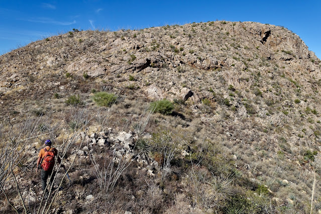
Less than half a mile from the junction at 3.2 miles, 3,920 feet, leave the wash and start climbing the roller. The knob is distinguished by the cluster of boulders on its head.
It's not too steep. There are shindaggers but you can mostly avoid them. The brush isn't bad. It feels so good to be going uphill, finally. Toward the top you'll work around some granite boulders with good examples of case hardening.
Top out at 4,220 feet and get a good look at the remainder of the route. It was starting to look like fun. Give up about 40 feet, staying on the ridgeline. On our return we cut off the top of the roller on the south but the further south you go, the brushier it gets. In retrospect, I wish we'd just gone back over the top. (THW, photo)
Simply follow the ridge as it curves from southwest to north. Go directly over one more insignificant roller in the arc.
Below, my partner is nearing the summit ridge. The ridgecrest is mildly scrambly with mostly fractured boulders and a few nice big ones. I admit to being a little disappointed. I was hoping the mountain would have more of a solid stone structure like Elephant Head.
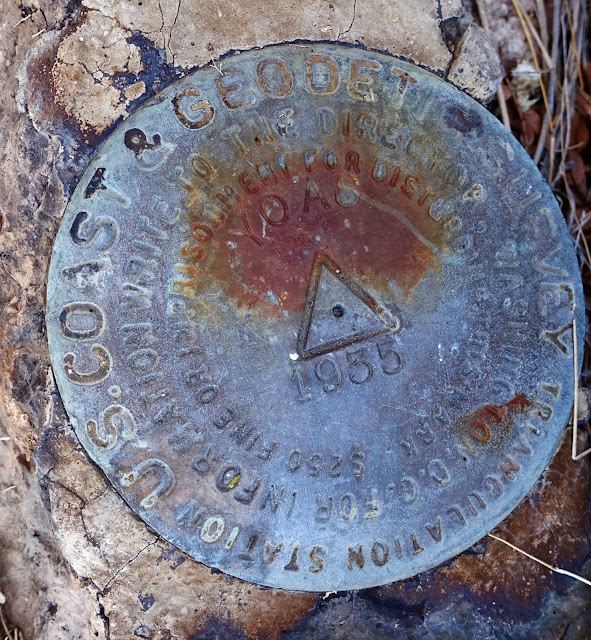
We crested at 3.7 miles after 800 feet of vertical. The top was covered in pointed rocks so it didn't qualify as a picnic peak. It's worth noting that we are pretty darn close to the international border with Mexico. Judging from all the trash strewn about, this is a migrant holdout. The Yoas Benchmark was placed in 1935. The registry dated to 2019. The next entry was in November of 2022 when Mike Williams signed in. The beta we had for this hike crossed private land so I'd like to thank Mike for turning us on to this public lands route. Check out his excellent description and track in Hike Arizona.
The lookout from Yoas is much better than its 371-foot prominence would imply. There is an intimate perspective on the south face of Elephant Head. I assume that everyone climbing Yoas has been up Elephant Head, but just in case...On my first climb we went up the Chino Spring Road apiece and then did a "shortcut" straight up Chino Canyon. It was brush infested with Class 3 bouldering. It would be faster to stay on the road to the standard route on the Quantrell Mine Trail. Of personal interest, I left my boots at home that day and did the whole hike in backless clogs. (THW, photo)
The Fred Lawrence Whipple Observatory can be seen on the summit of Mount Hopkins at elevation
8,585 feet. While there are facilities at three different elevations the summit observatory is operated jointly by the Smithsonian Astrophysical
Observatory and the University of Arizona for solar system, galactic and
extragalactic astronomy. Tree-clad Pete Mountain, shown, is typically climbed from the Old Baldy Trailhead.
The escarpment encircling Little Elephant Head gives one pause. Hikers are fortunate to have a walk-up on the south ridge. (THW, photo)
From this perspective, Devils Throne is clearly visible south of Devils Cash Box. There is an exposed Class 3 route up its south ridge that is way fun for experienced scramblers. (THW, photo)
Baboquivari Peak resides in the west beyond the Santa Cruz River valley. The beautiful intervening range is the Cerro Colorado Mountains. (THW, photo)
As you leave the summit be sure to make a hard turn onto the east ridge. It would be all too easy to skitter right down the south ridge. On our hike, our little group separated momentarily and at the low-point junction, our friend absentmindedly started walking down the Chino Spring Road. I was on alert because I didn't see his boot prints going uphill. It took a little while to sort this out. It was a gentle reminder not to separate out in the wild. Upon reaching the Chino Spring Road you've got some ascending to do. It's roughly 950 feet from the low point back up to the 4,700-foot saddle.


2 comments:
4259 is indeed quite nice and a bit airy on the summit ridge if you've got the time. Chino Basin was apparently named for the Chinese laborers who did the work there.
Thanks for weighing in on Peak 4,259' Chris. I'm sorry we had to pass it up. Debra
Post a Comment