Essence: There is something magical about climbing a peak that looks downright impossible, and yet, a passage is revealed as you ascend. The Picketpost Mountain Trail is not established or maintained. It is little better than it was in 2011 when I first hiked it solo. The climb is steep with friction pitches on clean bedrock and slick, loose material. There are multiple braids. Pick a
line you are comfortable with. If you get into exposed Class 3 terrain, back out and work another path. I can't overstate how fun this adventure is for hikers in reasonable shape with some experience scrambling and navigating. The stand-alone peak has a rise of 1,475 feet and superlative views. Strong hikers could climb the peak and then circumnavigate the mountain on the same day. Linked perimeter trails highlight the many faces of Picketpost. Take a fascinating tour of volcanic stone features on the east and west slopes. Both hikes are on public land managed by the Tonto National Forest.
Travel: For those traveling from the west, from Florence Junction (US 60 and AZ 79), mile marker 213, drive east on AZ 60 for 9.5 miles to mile marker 221.5. Turn south on FSR 231, signed Picketpost Trailhead. At 0.3 mile turn east on FSR 310 as directed. Pull into the large parking lot at 1.0 mile. For those traveling from the east, from the junction of AZ 177 and US 60 in Superior, it is 5.1 miles to mile marker 221.5. The graded dirt roads are 2WD accessible. Pit toilets, picnic tables, no water, no fee.
Travel: For those traveling from the west, from Florence Junction (US 60 and AZ 79), mile marker 213, drive east on AZ 60 for 9.5 miles to mile marker 221.5. Turn south on FSR 231, signed Picketpost Trailhead. At 0.3 mile turn east on FSR 310 as directed. Pull into the large parking lot at 1.0 mile. For those traveling from the east, from the junction of AZ 177 and US 60 in Superior, it is 5.1 miles to mile marker 221.5. The graded dirt roads are 2WD accessible. Pit toilets, picnic tables, no water, no fee.
Distance and Elevation Gain: Peak, 4.6 miles; 2,100 feet. Circumnavigation, 9.0 miles, 900 feet
Total Time: Peak 3:00 to 5:00; Circumnavigation, 4:00 to 5:30
Difficulty: Peak, braided trail; navigation moderate; Class 2+ with mild exposure. Perimeter, Class 1 trail; navigation moderate; no exposure; carry all the water you will need and hike on a cool day.
Map: Picketpost Mountain, AZ 7.5' USGS Quad
Latest Date Hiked: January 19, 2025
Quote: And above all, watch with glittering eyes the whole world around you because the greatest secrets are always hidden in the most unlikely places. Those who don't believe in magic will never find it. Roald Dahl
By virtue of its isolation and structure, Picketpost Mountain is a draw for the people of Arizona on the order of Weavers Needle and Baboquivari Peak. But unlike the two technical landmarks, the summit of Picketpost is attainable for strong hikers.

Route: For the peak climb, head south on the Arizona Trail. Branch onto the unsigned Picketpost Mountain Trail and climb southeast to the peak. For the circumnavigation, hike counterclockwise for the best perspective on the varied faces of Picketpost. Hike south on the Arizona Trail, east along a west fork of Telegraph Canyon to FSR 4, northeast to the Arnett Canyon Trail, and northwest on the L.O.S.T. Trail back to the trailhead. There are several junctions with no signs on the circuit. Carry a map or a GPS track. It would be easy to get lost out there.
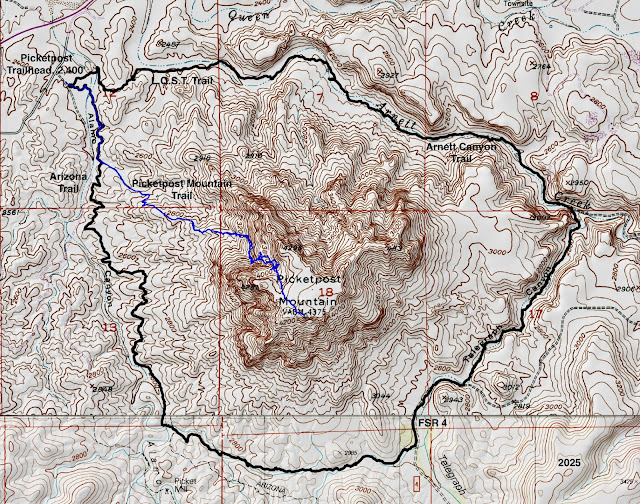
Route: For the peak climb, head south on the Arizona Trail. Branch onto the unsigned Picketpost Mountain Trail and climb southeast to the peak. For the circumnavigation, hike counterclockwise for the best perspective on the varied faces of Picketpost. Hike south on the Arizona Trail, east along a west fork of Telegraph Canyon to FSR 4, northeast to the Arnett Canyon Trail, and northwest on the L.O.S.T. Trail back to the trailhead. There are several junctions with no signs on the circuit. Carry a map or a GPS track. It would be easy to get lost out there.
Picketpost Mountain Summit Climb
First off, Picketpost is spelled with one word in spite of what's implied on the information placard at the trailhead. Please note that dogs must be leashed. This is not a dog-friendly hike. Nevertheless, on the weekend we passed a steady stream of hikers with kids and dogs in tow. (Thomas Holt Ward, photo)

Begin both peak and perimeter hikes by heading south on the Arizona National Scenic Trail (AZT). The Picketpost Trailhead, elevation 2,400 feet, is 300 miles along the 800 mile cross-state trail from Mexico to Utah.
The trail immediately crosses the waterway in Alamo Canyon. A sign cautions against fording the creek when flooded. In January of 2025, the streambed was stone dry. The desert was desiccated from three parched months. We kicked up billows of dust with each footfall. Nothing was blooming. Plants that are acclimated to the Sonoran Desert were shriveling and turning brown: saguaro, palo verde, jojoba, pricklypear, and varieties of cholla including staghorn, chainfruit, and teddybear.
At a quarter mile there is a signed junction with the L.O.S.T. Trail. This is the conclusion of the circuit around the mountain. For the peak climb, stay on the AZT. The unsigned turnoff onto the Picketpost Mountain Trail is at 0.6 mile. Leave the AZT and head southeast.

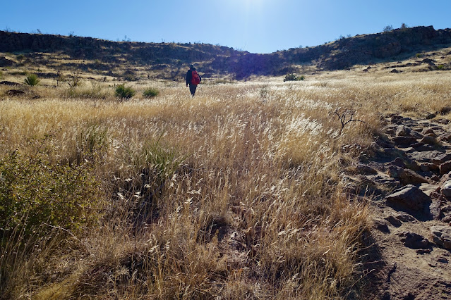
The footpath is a well-established trail to begin, winding up onto the bajada. Backlit grasses were the color of January. The mountain has a structure typical of peaks born of volcanogenics. Vertical cliffs composed of welded ash-flow tuff are painted with lime-yellow lichen. I was elated to be present in this panoply of color and texture. (THW, photo)

The trail gains a ridgelet topped with big boulders. This image looks back northwest to Weavers Needle and Superstition Mountain.

From the ridgetop the route to the summit remains mysterious, likely exciting for some and intimidating for others. Looking at the image below, the standard route climbs toward the cliffband, image-center-left, does a lateral into the defile, and ascends the gully a short distance before moving back north to punch up through a weakness in the cliffs, unseen below.
Of note, the trail to the summit is severely braided, in part because there are several viable routes up the mountain and no best way. Directional arrows spray painted on boulders long ago have thankfully
faded. Cairns can be helpful but they are sporadic and can lead one astray. Rely on experience and intuition, opting for the most comfortable path. Some choices are more exposed than others. If you find a good line on the ascent, keep turning around and memorizing landscape features so you can replicate the moves on your way back down.

A couple of
landscape markers are helpful. The first is at 3,100 feet where the small ridge butts up against the highly angled west slope of the mountain. Below, two hikers are standing on the Class 2+ pitch you must hit.

Scampering up the pale rock is where the excitement begins. Exhilaration! From there, the hike becomes a climb
ascending 1,275 feet in 0.8 mile.

The route points east toward the cliffs, ascending on the north side of the main defile.

At 3,360 feet, the route turns south and makes a lateral toward the gully. There are splinters and choices. We found a super fun, scramble-rich option.

The crack I am climbing is within the Apache Leap Tuff formation. It is composed of welded crystal-rich ash-flow tuff, pink-gray in color. Notice the metamorphic gneiss stones cemented within the breccia. (THW, photo)

There are various entry points into the throat of the ravine bifurcating the west slope. The second important landscape marker, a stone draw, is at 3,700 feet. It is one of the most beautiful structures on the mountain. (THW, photo)

Again, take note of where you entered the draw so you don't blow by your exit on the descent.

Cliffs head the top of the ravine.

The route is forced out of the defile and jogs north to a break in the upper cliffs, shown. Seen from any distance it is clear that the column-forming rock on the upper mountain differs from the formation below. The high cliffs are composed of a volcanic rock called quartz latite. The rocks are phenocrysts of quartz, biotite, hornblende, and feldspar in a glassy matrix.

On our ascent we followed cairns into a Class 3 crack slightly south of the standard weakness. We were definitely off route. The pitch was ultra steep and material loose so the slide potential was serious. To exit, we climbed a ten-foot wall with marginal but functional-enough holds for adept scramblers. While we enjoyed the crack I can not recommend it for Earthline readers.
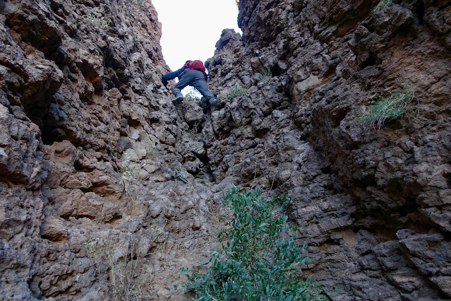
Below, I am scrambling out of the crack at the top of the wall. (THW, photo)

We emerged from the crack at 4,000 feet. This image looks down on the proper route at the same elevation.

The climb graduates considerably and the trail is once again uniform and defined through the dramatic finish. Native grasses are tempered by beargrass, sotol, and pricklypear.
Looking back from very near the summit, the trail is located between points 4,281' and 4,296'. The top of the mountain splays out gently in three directions. If I do this hike again, I'll visit all three of the numbered points.

Arrive on the crest of Picketpost Mountain at 2.3 miles. There were multiple peak registers placed inside a black mailbox. This is clearly and understandably a popular destination. In 2015 the mailbox was red and a metal bench sat nearby. (THW, photo)

The Picketpost Benchmark was cemented in place in 1936. (THW, photo)

The freestanding peak is a superlative vantage point. Looking northeast past Point 4,113' is the small town of Superior. It has a rich history of truth and legend associated with Picketpost Mountain on its western flank and Apache Leap on the east. (THW, photo)

Looking southeast, directly below the mountain are Telegraph and Arnett canyons featured on the circuit hike. Directly beyond is The Spine in the White Canyon Wilderness. There is no alternate secret route off this mountain. Retrace your steps or make only minor adjustments. (THW, photo)

Picketpost Mountain Circumnavigation
From the Picketpost Trailhead, elevation 2,400 feet, walk south on the AZT.

At 0.25 mile pass by the junction with the L.O.S.T. Trail. To do the circuit counterclockwise as described in this post continue straight on the AZT.

Stay on the AZT when the Picketpost Mountain Trail branches east at 0.6 mile. If you are doing the circuit after climbing the peak you will join the loop here. The uphill grade is mellow on the flowing, undulating, and winding trail. If there is but one purpose of this hike, it is all about visually appreciating this captivating mountain from every angle. For example, the vertiginous, faceted escarpment on the west face of Point 4,281' argues strongly for a visit while on the mountaintop.

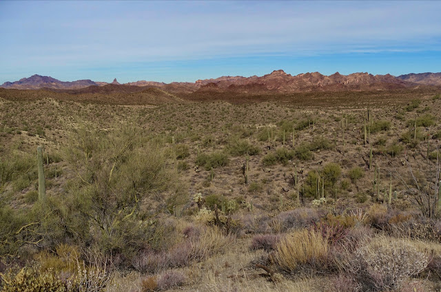
There is a unique perspective on the Superstition Mountains. Adding to the flora mentioned earlier are mesquite, barrel and hedgehog cactus, agave, and ocotillo. Drought deciduous brittlebush had shed all of its foliage and wasn't even thinking about blooming.
The summit of Picketpost is visible briefly from this angle on the southwest face. Notice the contact between the two different volcanic rock formations. (THW, photo)

The trail gives up 100 feet to come alongside Alamo Canyon at creek level, 2.2 miles, 2,600 feet. We were with friends who did the circuit in the spring of 2024 when the washes were flush. I couldn't help but wonder what this hike would look and feel like if water was running and wildflowers were blooming.
The footpath swings east and ascends to the high point of the hike. At 3.5 miles, 2,880 feet, the AZT heads south, signed with a carsonite marker, shown. The perimeter trail leaves the AZT and bears east. Be aware that the circuit strings together several trails and most of the junctions are not signed. 
The multi-tiered south face of the mountain rises up from a broad spread of alluvium to confront vertical cliffs of welded tuff which are overlaid with quartz latite. There are cave openings, big and small, all over the surface. (THW, photo)
The multi-tiered south face of the mountain rises up from a broad spread of alluvium to confront vertical cliffs of welded tuff which are overlaid with quartz latite. There are cave openings, big and small, all over the surface. (THW, photo)

Descend along a west tributary of Telegraph Canyon. We paused to search for the mailbox on the summit but were unable to get a bead on it, or any hikers on the high point. (THW, photo)

We intersected Forest Service Road 4 at 4.1 miles in Telegraph Canyon. Walking northeast it was clear that the footprint of Picketpost Mountain was expanded on the east and north. Point 4,113 is image-right.

FSR 4 was marked with a carsonite marker placed by the Tonto Recreation Alliance. The non-profit partners with the Forest Service to keep hundreds of
miles of OHV trails open. We saw tire tracks but no vehicles.

When the road turned east at 4.6 miles, we followed a large cairn on a 90 degree left, staying in Telegraph Canyon, shown. This critical unsigned turn would be all too easy to miss.

At 4.8 miles, stay in the canyon at a pouroff or do a short bypass downcanyon-left. Stone pools and drops would be delightful if water was running. At 5.2 miles we heard trickling and sure-enough, a slip of water was flowing in the streambed. There was green vegetation in the mesquite bosque. The trail was not well-defined in this area but no worries. Just stay on the floor of Telegraph Canyon. We encountered one small party of hikers on the entire circuit and several people on horseback. (THW, photo)

The canyon is visually engaging, enclosed between magnificent orange and gray cliff walls. (THW, photo)

A remarkable rhyolite earth pillar is located at the confluence of Telegraph Canyon and Arnett Creek at 5.8 miles. The standing stone has been separated from a dike or remnant wall. Open and close a gate. The circuit turns northwest on the Arnett Canyon Trail. (THW, photo)

There are numerous whimsical stone features composed of welded tuff. The organic shapes seemingly without logic kept us enthralled all the way back to the trailhead.

At 6.2 miles the L.O.S.T trail joins from the north and turns west. This is the end of the Arnett Canyon Trail. L.O.S.T. is an acronym for Legends of Superior Trail. It begins in Queen Creek Canyon, runs through the historic mining town of Superior, and ends at the AZT near the Picketpost Trailhead.

The trail tracks along the Arnett Creek corridor. Pass by a weathered tuff wall topped with soft crenelations.
(THW, photo)

At 7.4 miles there are mysterious palm trees on both sides of the wash. (THW, photo)

Grass, stone, saguaro, and sky are quintessential elements of the Sonoran Desert. (THW, photo)

Wrapping up the circuit, at 8.4 miles, the trail splits at a signed junction offering two choices back to the trailhead. The 0.8 mile option closes the loop at the AZT a quarter mile from the trailhead. The 0.6 mile alternative passes through a gate and climbs a masterful staircase carved into the bedrock. (THW, photo)
At the top of the stairs walk out onto a sheet of tuff overlooking the northwest face of Picketpost. The circumnavigation comes full circle at the east side of the parking lot.

No comments:
Post a Comment