Essence: The objective of this hike was to complete the traverse from Osobavi Peak to La Jolla Peak, walking toward Baboquivari Peak from the south. Given the immensity of Baboquivari watching our every move, it is understandable why the landmark is at the heart of the origin story of the Tohono O'odham people. We thought this segment would be straightforward but we discovered many time-consuming obstacles on "La Jolla Ridge." The complexity and raw beauty of the ridgeline far exceeded our expectations. The crest of the north-south running Baboquivari Mountains divide marks the eastern boundary of the Tohono O'odham Nation. Ascend to the divide on an east-trending ridge. Scale slightly tricky Point 5,704' on the return. A well-established migrant trail runs along the divide. It is advisable to hike with a companion or two. The hike is primarily on Arizona State Trust Land. The first mile is on a designated access route through a public easement. The standard route to La Jolla Peak is from Thomas Canyon. That is a shorter hike but the road is demanding even for 4WD vehicles.
Travel: There is a Chevron station on the Ajo Hwy, AZ 86, at Three Points, Robles Junction. Drive south toward Sasabe (Port of Entry) on AZ 286 through the Buenos Aires National Wildlife Refuge. It is about 30 miles to mile marker 15.8, just past a big pullout on the west side of the highway. Turn west on an unsigned road and measure distance from there. Cross a cattle guard. There is plenty of dispersed camping. The graded road has some washboard. At 2.6 miles go left at the split following a hand painted sign for the Mormon Corral. At 3.1 miles turn right when the road to Mormon Corral goes left. At 5.5 miles turn right following the sign for the designated access route around private property. (If you were to continue, in a quarter mile you'd come to a locked gate posted, "Dead End, Private Property, No Trespassing.") Park in front of boulders on your left in a wash at 5.6 miles. Display an Arizona State Trust Land permit. The trailhead is 2WD accessible.
Travel: There is a Chevron station on the Ajo Hwy, AZ 86, at Three Points, Robles Junction. Drive south toward Sasabe (Port of Entry) on AZ 286 through the Buenos Aires National Wildlife Refuge. It is about 30 miles to mile marker 15.8, just past a big pullout on the west side of the highway. Turn west on an unsigned road and measure distance from there. Cross a cattle guard. There is plenty of dispersed camping. The graded road has some washboard. At 2.6 miles go left at the split following a hand painted sign for the Mormon Corral. At 3.1 miles turn right when the road to Mormon Corral goes left. At 5.5 miles turn right following the sign for the designated access route around private property. (If you were to continue, in a quarter mile you'd come to a locked gate posted, "Dead End, Private Property, No Trespassing.") Park in front of boulders on your left in a wash at 5.6 miles. Display an Arizona State Trust Land permit. The trailhead is 2WD accessible.
Distance and Elevation Gain: 10.3 miles; 2,700 feet
Total Time: 6:30 to 8:00
Difficulty: Trail, 4WD track, off-trail; navigation moderate; Class 2+ with no exposure; hike on a cool day and carry all the water you will need.
Maps: Mildred Peak; Baboquivari Peak, AZ 7.5' USGS Quads
Date Hiked: March 16, 2025
Quote: For some time now it has seemed to me that two questions we should ask of any strong landscape are these: firstly, what do I know when I am in this place that I can know nowhere else? And then, vainly, what does this place know of me that I cannot know of myself? Robert Macfarlane
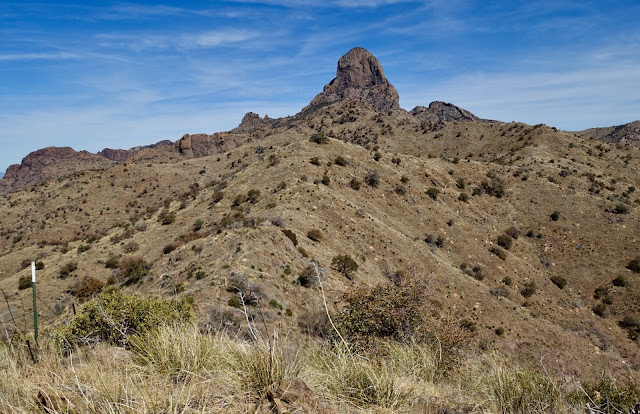
Seen from Point 5,704', La Jolla Peak (fourth knob from the left) is cherished for its proximity to Baboquivari Peak. However, the challenging ridgeline is such a pleasure the mountain would be a draw even in isolation.

Route: From parking, walk west on the designated access route for one mile. Transition onto a 4WD track on Arizona State Trust Land. Turn north into Jupiter Canyon. Just past the dams we took an east-trending ridge to the divide, gaining it where we left off the month prior on our Osobavi Peak hike. If you wish, you could ascend on our return ridge featuring Point 5,704'. Once on the divide, hike north to La Jolla Peak.

Watch for the directional sign posted on the incoming road at 5.5 miles.

The designated access route is sponsored by Arizona Game and Fish. From
parking, elevation 3,980 feet, begin walking west through coarse gravel in Shaffer Wash.
At 0.3 mile turn out of the wash and onto a singletrack, paralleling the watercourse on its north. Follow signs carefully. Little bits of faded orange flagging mark the route through a maze of stock trails. At 0.4 mile, cut around the perimeter of corrals on the north. They are constructed with pipes and juniper logs, very similar to the exceptional corrals in nearby Thomas Canyon.

Climb over a gate posted, "Private Property, Foot Access Permitted."

Pass a dissolving adobe outbuilding and dilapidated house. The designated access route returns to Shaffer Wash and merges onto the 4WD track at 1.0 mile. Both technical Mildred Peak (image-left) and Osobavi Peak have strong appeal.

At 1.5 mile turn north into Jupiter Canyon. La Jolla Peak stays hidden but keep in mind it is one mile due south of Baboquivari Peak.

Notice the gray standing stones on the right at 1.7 miles. This is the first of several dikes this hike will pierce. Pass an adit associated with the Jupiter Mine which functioned in the canyon from 1930 to 1941. The road passes through a dike punctured by the waterway at 2.4 miles, shown. Go left at the next split and cross the canyon below a cement dam. (Thomas Holt Ward, photo)

At the top of the first rise, 4,440 feet, 2.6 miles, leave the road and ascend west-northwest. It is steep, loose and slick. Intercept a primitive trail about 100 feet up.

The grade softens at 4,800 feet. (THW, photo)

The Baboquivari Mountains are composed of Mesozoic sedimentary and volcanic formations. The
Mesozoic Era lasted from about 252 to 66 million years ago. The ridge is topped with purple slabs of stone with a black sheen. Baboquivari Peak and the dikes are composed of Baboquivari
Granite, a much younger rock from
the Tertiary Era, 66 to 2 million years ago.

Superlative views from the ridge include Osobavi, a draw due to its name, form, and accessibility. (THW, photo)

Our goal was to connect the dots and gain the divide where we left it after climbing Osobavi.

In mid-February the desert is typically putting on a vibrant wildflower display. However, in the spring of 2025 the drought was so severe we didn't seen even one flower blooming. Rainbow mammillaria were profuse throughout the hike. 
At 3.4 miles, 5,580 feet, we arrived on the divide. In retrospect, it's a good thing we didn't try to tack La Jolla onto the Osobavi hike because achieving the peak turned out to be slow and challenging, especially given our navigation errors. Turning north on the undulating ridge, walking was easy along the fenceline on a pounded use trail. Power emanating from the guardian is ever-present and undeniable.
The Tohono O'odham Nation splays out west of the divide. A permit is required for any hiking on the reservation.

We found a humanitarian water and supply stash adjacent to the trail. Undocumented
border-crossers and Mexican drug cartels are active in this area. (THW, photo)

We passed our east-bearing descent ridge topped by Point 5,704'. (THW, photo)

La Jolla is a shy peak that remained hidden until we were practically on top of it. The third knob below obscures the highpoint.

As we approached the south end of La Jolla Ridge we passed an emergency call sign, another indication we were on a migration pathway.

The ridge has four principal knobs. We took the migrant trail west of the first two but on our return climbed over the tops of them.

The west side trail winds up through large chunks of stone. 
At 5.0 miles, 6,000 feet, the trail returned to the ridgecrest. It flirted with one side of the ridge and then the other, throwing in some Class 2+ scrambling.

The trail saddled up against two massive boulders.

Past the boulders it worked best to stay as close to the ridgetop as possible, even when the trail moved to the west side. We thought for sure the knob shown below was the final mount to the summit. No! The highpoint is the fourth roller in the lineup.

Finally, the crest of La Jolla Peak comes into view. The third roller terminates in a short knife with a technical downclimb.

We didn't see the workaround on the east on our way up the mountain so
we dropped 200 feet off the spine on the west side. Don't even think
about that as an option. We crossed a treacherous scree field at the angle of
repose and then clawed our way to the saddle just south of the peak on an extremely steep slope. For the Class 2+ option, just before the knife, find a downclimb on the east side of the ridge, shown. It is not as precipitous as it looks. You will intercept a trail that goes north to the saddle. Now that we know how to do this correctly, La Jolla Ridge is pure
pleasure.

If you wish, there is a solid Class 3 option on the east side, shown.

From the saddle, the final moderately steep heft to the summit on grass and rock is fun and easy. This is the hidden magic path to La Jolla Peak from the south.

We alighted on the summit at 5.4 miles. The small crest with a rise of 330 feet had good sitting rocks but no peak register. The Buenos Aires National Wildlife Refuge is to the east in front of the Cerro Colorado Mountains.
(THW, photo)

The summit block is precipitous on the north. The primary purpose of this route was to approach Baboquivari Peak from the south spending the day in the presence of the monolith. (THW, photo) 
In this closeup, you can see (and scout) some of the principal climbing routes.

Look west into the Tohono O'odham Nation.

La Jolla is on the list of Southern Arizona Hiking Club peaks. They start the hike in Thomas Canyon, shown. If your primary purpose is to bag the peak (and you have a vehicle capable of handling the technical road) the SAHC route is ideal. If you wish to savor the walk toward Baboquivari, approach from the south.

Having botched the route from the third knob to the peak we were elated to find the elegant, east-side bypass.

On our return we went over the two southernmost knobs and intersected the trail. (THW, photo)

The south side of the second roller was especially entertaining. (THW, photo)

We reached our east ridge descent route at 6.2 miles, 5,780 feet.

Point 5,704' is composed of crumbling bedrock and rubble. We picked our way carefully up the west ridge.

The conglomerate was so ancient it was becoming unglued making the ground skittish.

The crest is a delight. We could even see La Jolla from there, the only place the peak showed itself from a distance. (THW, photo)

The first 100 feet coming off Point 5,704' had some slick dicey bits. (THW, photo)

The descent on the grassy broad east ridge was quite easy. When I visualize the topography at the bottom of Arizona, this is the scene I conjure. (THW, photo) 
Intercept the road in Jupiter Canyon at 4,520 feet. About 30 yards before the first dam turn right to stay on the road. We closed the loop at 7.7 miles. Historic mines stilled, under the protection of an overarching oak, walking down the abandoned road felt peaceful, even pastoral. (THW, photo)

At 9.3 miles, follow the signage left out of Shaffer Wash road and back onto the private land bypass. Deep into the afternoon, the air untroubled, shadows long, the sun's warmth on our backs, our intention fulfilled, we walked in contented silence.

No comments:
Post a Comment