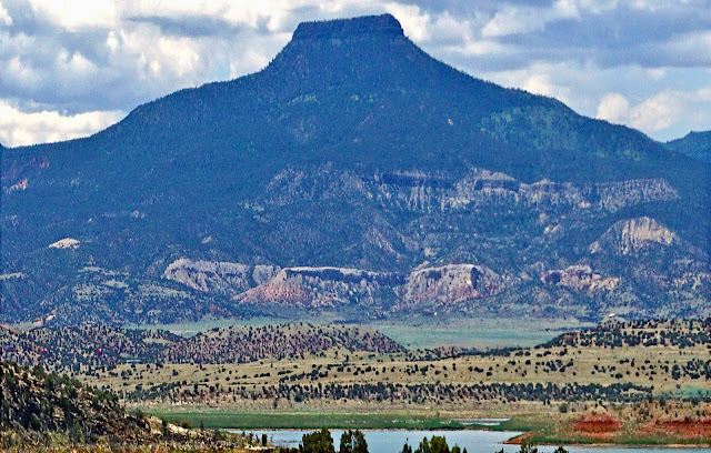
Essence: Climb two ranked summits in the Chalk Mountains southeast of Pagosa Springs. The hike is within the South San Juan Wilderness, 158,790 acres at the southeast run of the San Juan Mountains and a few miles north of the New Mexico state line. Navajo Peak is an airy sphere and Peak 11,409' is a tiny highpoint on a long and slender ridge composed of bubbly andesite. The moderate statistics do not tell the true story. There was nothing tame about this raw hike. The two access ridges creating an embedded loop are hard to locate and unrelentingly steep. While we loved this challenging hike, it is not for everyone. LiDAR has increased the elevation of the Navajo 2 Benchmark by four feet to 11,327 feet with a rise of 324 feet. Peak 11,409' was decreased by seven feet to 11,402 feet with a rise of 328 feet. The hike is within the San Juan National Forest. The route would be exceptionally beautiful when the aspen turn in autumn but you will be sharing the terrain with hunters.
Travel: US 84 runs southeast from Pagosa Springs, CO to Chama, NM. In the hamlet of Chromo (four miles north of the New Mexico border), turn east on the first road south of the Navajo River, mile marker 4.4, and measure distance from there. County Road 382 (Navajo River Road) is unsigned at the intersection. Navajo Peak is visible from the graded gravel road. It parallels the Navajo River on the south side. At 5.8 miles pass the Oso Diversion Dam. A cinnamon-colored black bear dashed across the road feet in front of us. Soon after, a buck in velvet did the same. Watch your speed. Cross the Navajo River at 6.5 miles. At 7.7 miles turn left on FSR 731, Price Lakes Road. The Forest Service gate was open. The curvy road narrows and climbs gently. Dispersed camping is abundant. At mile 15.2 the road ends at a large parking area and turnaround at the Navajo Peak Trailhead. No facilities. 2WD vehicles should be adequate.
Distance and Elevation Gain: 6.3 miles; 2,700 feet
Total Time: 5:30 to 7:30
Difficulty: Trail, primarily off-trail; navigation challenging; Class 2 with no exposure; steep with loose rock and poor footing.
Map: Chama Peak, Colorado 7.5' USGS Quad
Total Time: 5:30 to 7:30
Difficulty: Trail, primarily off-trail; navigation challenging; Class 2 with no exposure; steep with loose rock and poor footing.
Map: Chama Peak, Colorado 7.5' USGS Quad
Date Hiked: June 23, 2025
Poem:
Some nights elk whistle & lions howl
Coyotes in the canyon
The evening lisp of the aspen trees...
Even tarantulas on a trek
Padding across the highway
To get down to the river
Lots of talking
going on around here
If you're listening.
Art Goodtimes
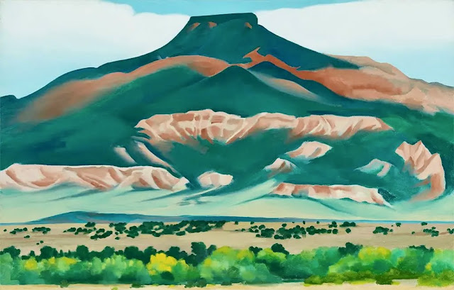
Navajo Peak is visible from US 84 for many miles and consequently it was on our radar for some years. I mistakenly assumed there would be a pounded path to the summit from other kindred spirits. But there were no signs of human passage and we waited below the peak until two playful cougar siblings cleared off the top. Below, from the left is Navajo Peak and Point 10,938'.

Route: Hike northeast on the Navajo Peak Trail for about one mile. Use a GPX track or compass to locate the ascent ridge in heavy woods. Climb east and gain the divide running north from Navajo Peak. Climb Navajo and then walk north to Peak 11,409'. Return to the descent ridge and plunge southwest to the forest floor. Hold a southwest bearing to intersect the Navajo Peak Trail. Retrace steps to the trailhead.
Route: Hike northeast on the Navajo Peak Trail for about one mile. Use a GPX track or compass to locate the ascent ridge in heavy woods. Climb east and gain the divide running north from Navajo Peak. Climb Navajo and then walk north to Peak 11,409'. Return to the descent ridge and plunge southwest to the forest floor. Hold a southwest bearing to intersect the Navajo Peak Trail. Retrace steps to the trailhead.
Navajo Peak Trail #577 doesn't go to the peak but it is handy for getting the hike started. The West Trailhead for the seven mile thru-hike is off FSR 663, Buckles Lake Road. We signed the trail register at the East Trailhead, elevation 9,380 feet, and headed north across an open meadow.

Enter a deep forest with many trees at their maximum for height and girth: towering aspen, Douglas fir, and Engelmann spruce. The smooth dirt path plowed through stands of ferns up our chests. Wildflowers were diverse so I kept a running list as we walked along. Shade-loving flowers, sunny ridgeline flowers--the list is at the end of this post.
(Thomas Holt Ward, photo)

Cross a small stream right away. At 0.75 mile there is an alluring view of Navajo Peak presiding over a lush meadow with a small watery disk. This image was shot in the afternoon when the sun shone directly on the spherical peak and the linear white trunks of the aspen.

Navajo Peak
Our plan was to ascend a west running ridge that would deposit us on the Chalk Mountains divide just north of Navajo Peak. After climbing both summits, we planed to descend on a southwest running ridge and arrive back on the trail roughly where we left it. We couldn't see the ascent ridge from the trail so it was hard to get a bead on the best place to leave the path. We stepped off the trail at 0.9 mile, 9600 feet, but we could have gone as much as 0.1 mile further before turning off. I thought for sure there would be a social trail, a series of cairns, something, to guide us. Nothing. The forest floor was thick with snowberry and deadfall littered the surface. We couldn't even see our feet for half a mile. Carry a GPX track or be adept with a map and compass. You won't see the ridge until you are right on top of it.

I was fascinated to find historic arborglyphs in this seemingly random area. We happened upon an elk jawbone with teeth and later, a deer skull with the spine attached. There is a lot going on in these woods. 
We contacted the ridge at about 9,960 feet. In the next 0.7 mile we would pitch up 1,280 feet. By anyone's definition that is steep. (THW, photo)

The ridge narrowed, the blocks of rock grew bigger, loose material dislodged underfoot, fragments of a game trail came and went, and the grade was unrelenting. Pale new growth sprung from the tips of the fir trees. Woods' rose was blooming profusely. Put your nose in a flower for a burst of energy and elation. (THW, photo) 
The return ridge is adjacent to the north. 
We paused on a small landing to study the peak and its imposing west ridge. (THW, photo)

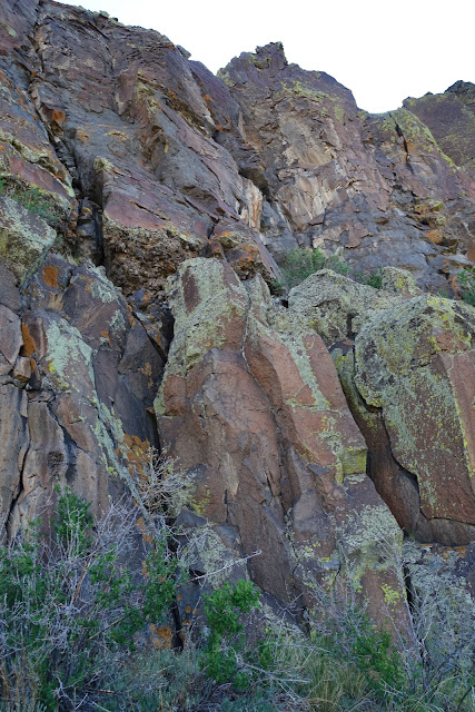
The hike is a tour of bold volcanic features. The Chalk Mountains are located within the San Juan Volcanic Field. The range displays an array of volcanic rock types. Andesite, an igneous rock, is the most common but these small knobs on the landing site are composed of breccia--born from explosive volcanism where rock fragments are cemented together.

Ascending on the thin stone ridgecap, it was disheartening to see more beetle-stricken trees at higher elevations.

We walked on weathered stone blobs covered with green lichen.

We intersected the divide at 2.0 miles, 11,180 feet. The summit of Navajo Peak was just 0.2 mile north. Looking at the stone chaos and the dead trees, my first reaction was, "That doesn't look possible!" In reality, the summit (image-right) is easily achievable. While paused to consider the route, we saw two mountain lions scampering all over the subsidiary peak on the left. In time, one flew down off the mountain. The other cat was in no hurry to go anywhere. We watched as it dashed all around and flashed its tail. Later that week we spoke with a wildlife biologist with Colorado Parks and Wildlife. He said cougar kittens remain with their mother for 18 to 24 months. After she separates from them, siblings commonly stay together for another two to three months. We waited for the juvenile cats to disperse and when we were pretty sure their mother wasn't on guard, we proceeded up the mountain...watching over our shoulders all the while!

We started up the ridgeline but immediately a gray gendarme composed of San Juan Explosive Volcanics looked troublesome.
We bypassed it easily on climber's right.

We worked around the second block on the right as well. The shiny, vertical walls looked like rhyolite, my favorite volcanic rock. (THW, photo)
There is nothing difficult about any of the moves on this hike. I'm including this photo because I like the fiery orange lichen and the structure of the block. Most Earthline readers who stumble on this post are unlikely to execute this hike so it feels important to show in images some of the forms that our Earth has sculpted. (THW, photo)

From the ridge junction, the sub-peak on the left looked taller but as we closed in, the stick protruding from the peak cairn identified the actual highpoint.

My partner is rounding the pole on the gray sphere.

Navajo Peak is over 3,000 feet above the Navajo River. The peaks on the east side of the river are on the Continental Divide. (THW, photo)

We crested the summit at 2.2 miles. For many years this peak had enticed us so it was a delight to be in its intimate presence at last. Here we were at the bottom of Colorado, at the southern terminus of the San Juan Mountains, standing on a large, airy ball that floats 1,500 feet above the forest floor on the south end. Take another look at the feature photo to comprehend the precipitous nature of this abrupt edge.

Someone unceremoniously propped a piece of dimensional lumber stuck with rusted nails into a pile of rocks serving as the peak cairn. There was no summit register. We were putting on our packs to leave when I noticed that a boulder with the cemented benchmark was thrown into the mix.

The disk was cockeyed but clear as day--"NAVAJO 2, 1954."

To the southeast, Chama Peak is the symmetrical twelver in the set of three mountains due north of Chama, New Mexico, and three miles (as the crow flies) north of the state line.

The Navajo Peak Trail passes south of V Mountain, the flat mesa, image-center.

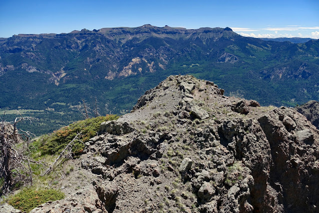
Look north to examine the route to Peak 11,409'. Bear north from the ascent ridge, dropping into the saddle. Pass west of Point 11,324', the impressive all-stone outcrop. Continue past the descent ridge with the cut-away south face. Go over Point 11,355', and crest Peak 11,409', image-center. To its left is Chalk Benchmark, 12,031', the highest point in the Chalk Mountains. 


There are two rollers on the way to the next peak. We climbed a couple hundred feet to our descent ridge and kept on going. Most of the trees at this elevation had been destroyed by beetles. Piles of bear scat were all over the ridge.

This image looks south to Navajo Peak and fearsome Point 11,324' from the gentle climb to Point 11,355'. (THW, photo)

The summit ridge of Point 11,409' is a hoot. It finishes with a 200-foot decidedly narrow ridge walk on strange, bubbly rock to a highpoint about three feet wide. It holds the record for our tiniest ranked summit ever with one or two rocks to perch on. It was hard to believe we'd only hiked 3.7 miles thus far.


We walked through a verdant glade surrounded by a stately, shimmering grove of aspen. As before, the foliage was thick and tall and visibility was limited. You will need a GPX track or a compass bearing to find your way back to the Navajo Peak Trail. We contacted it right where we left it in the morning at 5.4 miles. The smooth footpath was a pleasant conclusion to a rugged off-trail hike.
I was introduced to the wildflowers of Colorado while living in Crested Butte in the 1990s. A botanist friend kept a list of blooming plants on every hike and I adopted the habit. Following, is a list of the plants in blossom on this hike early in the season in order of observation: Colorado blue columbine, sneezeweed, mountain parsley, geranium, white peavine, heart leaf arnica, osha, Indian paintbrush, purple vetch, clover, white violet, strawberry, baneberry,
snowberry, bluebell, thimbleberry, false Solomon's seal, spotted coralroot, salsify, woods' rose, pussy toes, meadow rue, whiplash daisy,
dotted saxifrage, potentilla,
king's crown, cutleaf anemone, native honeysuckle, Fendler's sandwort, slender-tubed phlox, western valerian, elderberry, alpine phlox,
parrot beak lousewort, alpine avens, senecio, scarlet gilia, alpine sandwort, elderberry, yarrow, purple violet, current, chainpod, Rocky Mountain penstemon, and serviceberry.
We walked over to the subsidiary peak. Soft dirt patches were completely covered in cougar prints.
It afforded a holistic perspective on Navajo Peak. (THW, photo)
Peak 11,409'
From the intersect with the ascent ridge (shown), Peak 11,409' is 1.3 miles north. Staying on top or very near the ridgeline, descend steeply to the saddle at 11,020 feet (11,003 feet, LiDAR). 
Nothing is a gimme on the off-trail portion of this hike. Point 11,324' is constantly shedding material (don't linger). Footing was difficult as we walked across accumulated rubble. Oh for the dexterity and nimbleness of a cougar. 
We might have avoided side-hilling on babyheads by staying a little further out from the base of the wall. (THW, photo)
There are two rollers on the way to the next peak. We climbed a couple hundred feet to our descent ridge and kept on going. Most of the trees at this elevation had been destroyed by beetles. Piles of bear scat were all over the ridge.
Cutleaf anemone was having a banner year in 2025. Once out of the woods, we saw them throughout the hike. Anemone multifida thrives within a wide elevation span in Colorado, from 6,500 to 14,000 feet. Anemone lack petals and strong shades of red predominate in the sepals. (THW, photo)
Windflower, another common name, often have bicolored sepals. (THW, photo)
This image looks south to Navajo Peak and fearsome Point 11,324' from the gentle climb to Point 11,355'. (THW, photo)
Closing in on Point 11,355', Peak 11,409' is image-right.
The summit ridge of Point 11,409' is a hoot. It finishes with a 200-foot decidedly narrow ridge walk on strange, bubbly rock to a highpoint about three feet wide. It holds the record for our tiniest ranked summit ever with one or two rocks to perch on. It was hard to believe we'd only hiked 3.7 miles thus far.
Mike Garrett placed the peak register in 2014. We were intimately familiar with his distinctive registers as he has climbed all the peaks in Colorado over 12,000 feet. Subsequently, only five people signed in. Three of them were close hiking buddies. In 2016, legendary John and Alyson Kirk of Lists of John did a massive circuit that included Navajo Peak, Chalk Benchmark, and V Mountain for a total of 15 miles with 5,000 feet of vertical. There was something incredibly charming about sitting on a warm rock on the minuscule summit. I loved that little mountain and didn't want to leave. (THW, photo)
We were back at our southwest-bearing descent ridge at 4.3 miles, 11,220 feet, shown. The drop is pretty darn steep--1,420 feet in less than 0.7 mile. But the footing was good and the hike was enhanced by incorporating two ridges. The ridge was rather narrow and fell off steeply on both sides but there was no sense of exposure. 
The ridge offered up superb views of Navajo Peak and intriguing volcanic features.
This tower is one of innumerable inexplicable works of Earth art.
As the gradient eased we came to an area where the land had sloughed off. We simply played out the ridge to 9,800 feet. (THW, photo)
We walked through a verdant glade surrounded by a stately, shimmering grove of aspen. As before, the foliage was thick and tall and visibility was limited. You will need a GPX track or a compass bearing to find your way back to the Navajo Peak Trail. We contacted it right where we left it in the morning at 5.4 miles. The smooth footpath was a pleasant conclusion to a rugged off-trail hike.