Essence: Wheeler Peak is the highest point in New Mexico with a prominence of 3,401 feet. The peak is located in the Sangre de Cristo Mountains,
extending south for 250 miles from Poncha
Pass in Colorado to Santa Fe, New Mexico. Drive through Taos Ski Valley to access the trailhead. Trundle at length through the forest before breaking out into the alpine on expansive slopes of tundra and stone. Wheeler is a worthy peak for the state's highest. Join the regular procession of hikers rejoicing in the best that the earth has to offer and full-circle views. The well-engineered trail makes the peak accessible to everyone in good physical condition. For those who wish to see more of the mountain, hike south to Simpson Peak. The hike is within the Wheeler Peak Wilderness managed by Carson National Forest.
Travel: It is about 16 miles from the junction of US 64 and NM 150 to Williams Lake (and Wheeler Peak) Trailhead parking. Drive northeast on NM 150 past Arroyo Seco and up the Rio Hondo canyon to Taos Ski Valley. Follow signs for the Williams Lake Trailhead onto Twining Road. Pass Kachina Vista Municipal Park. The dirt road is well-graded but very steep, 4WD helpful. It is 1.7 miles up the switchbacking road to a right turn into the large parking lot. It fills in prime season so arrive early. Pit toilet. No water. Distance and Elevation Gain: Wheeler, 9 miles; 3,000 feet. Add Simpson, 1.3 miles; 400 feet
Total Time: 5:00 to 6:30; Simpson adds about one hour.
Difficulty: Trail; navigation easy; Class 2 with no exposure; do not underestimate the thunderstorm generating capacity of Wheeler Peak. During the monsoons, summit early and plan to be back down in the trees by noon.
Map: Wheeler Peak, New Mexico 7.5' USGS Quad
Date Hiked: October 6, 2023
Poem:
And far on high the keen sky-cleaving mountains
From icy spires of sunlike radiance fling
The dawn.
From icy spires of sunlike radiance fling
The dawn.
Percy Bysshe Shelley
A great wash of mid-day light illuminates Wheeler Peak with a high alpine intensity. Hikers reveling in enchantment are clustered on the summit in this image shot from Simpson Peak. (Thomas Holt Ward, photo)

Route: The Williams Lake Trail is the shorter of the two standard routes to the summit. (The other, the Bull-of-the-Woods Trail, is 16 miles round trip.) From parking, follow directional signs through Taos Ski Valley for half a mile to the actual trailhead. The footpath bears south for two miles before leaving the Williams Lake Trail and pitching east to the saddle with Mount Walter. Ascend south to Wheeler Peak. For those going on to Simpson Peak, descend the south ridge of Wheeler off-trail and pick up a ridgeline footpath to Simpson.


From Williams Lake Trailhead parking, elevation 10,200 feet, walk roughly south through the ski area following signs for the Williams Lake Trail, 0.5 mile afar. Note that by October the first three miles of the hike was in the shade of the Wheeler Peak ridgeline so the first series of images shown below were shot on our return from the mountain.

Cross the Lake Fork of Rio Hondo on a bridge and locate the start of the Williams Lake Trail, a single track at the base of a ski slope.

Trees have been thinned and shredded. The footpath skims along the base of a talus slope with impressive boulders.

Blue blazes mark the trail as it winds up through a climax sub-alpine fir forest. Flowers are asleep in October, moss drapes from the dense canopy, the forest floor is cluttered with fallen timber--the woods have a bedraggled appearance.

Enter the Wheeler Peak Wilderness at 1.0 mile, 10,600 feet. The trail bears south into a massive amphitheater enclosed by high ridges shedding water into Williams Lake. The power of erosion is on display as the trail traverses blockfields built by boulders exfoliated from the mountains above. Colorful lichen in shades of gray, green, pink, black, and white indicate that these rock piles have been in place for a very long time. The prominence seen below, incised with debris and avalanche chutes, is the end of a ridge extending eastward between Lake Fork and Kachina peaks.

The route to Wheeler Peak diverts from the Williams Lake Trail at 2.1 miles, 11,200 feet. The lake is a popular destination for half-day hikers.

The forest transitions from fir to old-growth Englemann spruce with characteristic swoops at the base of their trunks. The immaculate dirt treadway, softened with spruce needles, is a welcome respite for hikers heading downhill.
(THW, photo)

Pass alongside the first substantial outcrop, composed of metavolcanic gneiss, at 2.6 miles. (THW, photo)

Trees thin at 11,600 feet. Hardy shrubby cinquefoil thrives on open slopes. Mid-summer, they beam with profuse yellow blossoms. In the autumn their branches take on a purple cast.
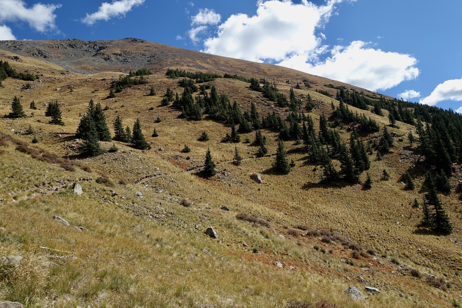
The vista to the west is wide open at last. The tallest point on the opposing divide is Lake Fork Peak. To its west is Point 12,535' with the distinctive summit cone. Between them is a rock glacier ever so slowly descending in folds toward Williams Lake. The prominence seen earlier with the series of chutes sits out front and Kachina Peak is on the far right.

Because the trail is on the west side of the Wheeler Peak ridgeline, the approach is stingy with sunshine. It was 33 degrees when we started hiking and we didn't break out into the sun until 3.2 miles, 12,000 feet! We were so elated we gave the prominent bench the name "Wheeler Park" and paused there for a warmup snack. (THW, photo)

The broad sweeps of tundra reminded us of the high alpine in Colorado. Undefined heaps and piles of rocks pocketed the landscape.

Extensive blockfields formed felsenmeers. The peak is visible from the Wheeler Park bench. It may look far away but the bulk of the elevation gain is accomplished and alpine euphoria is a proven power enhancer.

Trail engineering is commendable given the jumbled streams of stone that must be traversed. (THW, photo)

The generous trail platform is cleaved into a steep slope.

Switchbacks tighten and the procession of people above and below stand out. (THW, photo)

I've included this image because it captures the unadulterated power of this living bastion and the context in which it prevails. (THW, photo)

We are closing in on the divide.

This image was taken from the last corner before contacting the ridge. The peak is visible and due south from here. (THW, photo)

Arrive on the Wheeler Peak ridgeline at the Mount Walter saddle at 4.25 miles, 13,040 feet. It's always exciting to anticipate the whole new world that awaits. Look southeast across a high basin to the ridge extending from Simpson Peak (image-right) over Old Mike Peak to Red Dome. (THW, photo)

There are a couple of rollers on Wheeler's north ridge. (THW, photo)

For those tacking on Simpson Peak, the return trail links back up with the standard route north of the second roller. (THW, photo)

The summit is a rounded crest with room for the congregation of hikers standing on the highest point in New Mexico.

Alight on the summit at 4.5 miles. There are plenty of sitting rocks for the clusters of people rotating on and off the peak. (THW, photo)
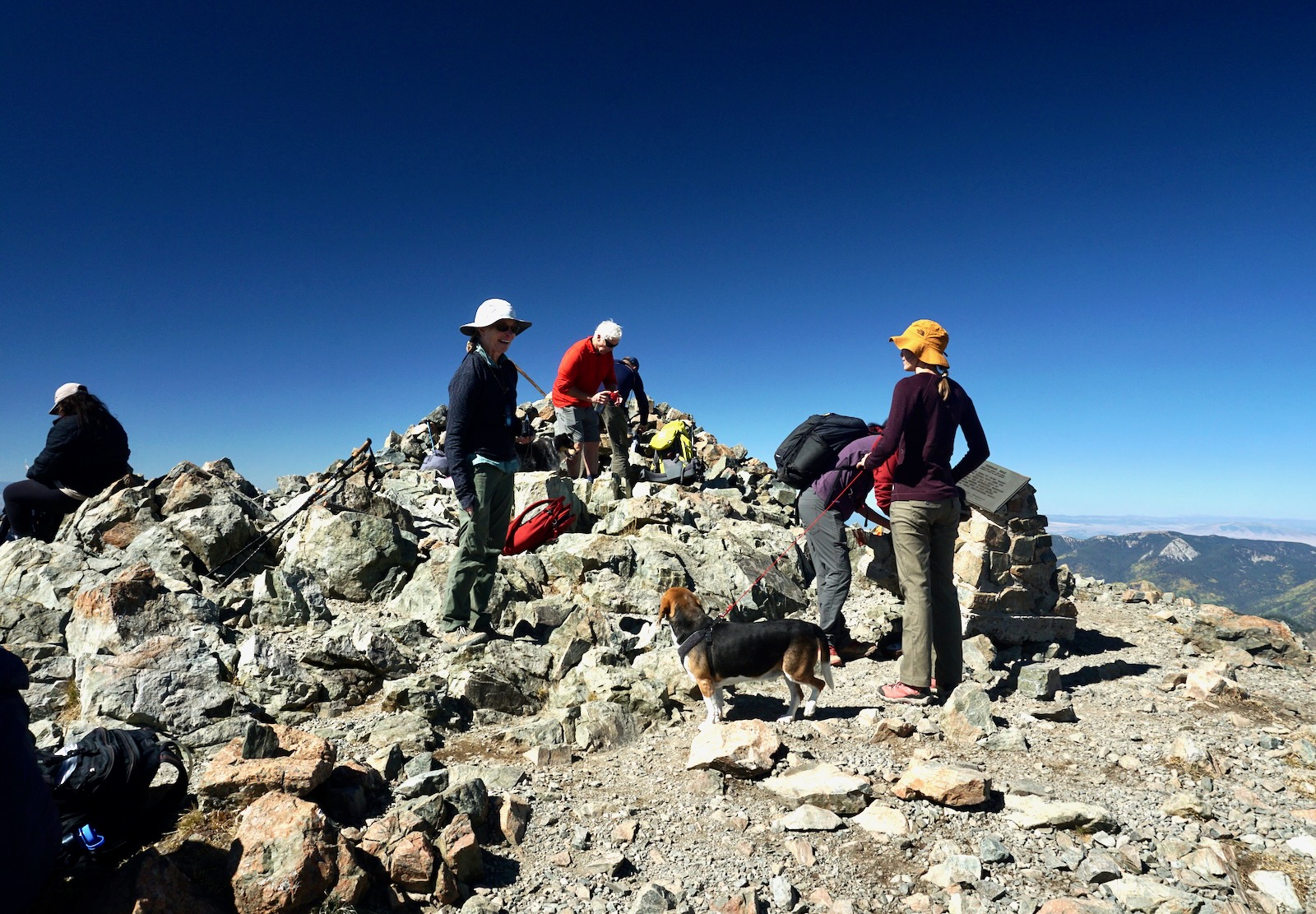
A plaque pays tribute to early surveyor, George Montague Wheeler. In 1872, Congress appropriated funding for Wheeler’s teams, officially establishing the United States Geographic Surveys west of the 100th Meridian. The group that measured the height of Wheeler did a commendable job. Just recently the peak was evaluated by LiDAR, the most accurate measurement technology available today. The peak's elevation was raised by a mere one foot to 13,162 feet. Curiously, multiple biographical sketches of Wheeler state he was born in 1842 (not 1832) and died in 1905.

The peak register is located in the steel pipe below the plaque. (THW, photo)

We were able to find a battered disk with a Reference Mark (unnumbered) but not the Benchmark. (THW, photo)

The image below looks northwest to Taos Ski Valley. Look closely and you'll see the trail emerging from the forest, crossing the Wheeler Park bench and switchbacking up toward the ridge.

Look back down the north ridge and up to Mount Walter. LiDAR raised its elevation from 13,133 to 13,140 feet. However with a rise of just 80 feet, it is not a ranked peak. Nevertheless, we would have happily climbed Wheeler's neighbor to the north were it not for the six hour drive home awaiting.

Simpson Peak, 12,976'
The optional spur to Simpson adds 1.3 miles, 400 feet of elevation gain, and one hour round trip. It will appeal to hikers who want to further explore the Wheeler Peak environs. Launch off-trail and get a better feel immediately for the mountain. There are scattered chunks of quartz on the south ridge. (THW, photo)

Pick your way through some talus. We heard a pack of coyotes yipping and yelping in the Williams Lake basin, a rare treat for us.

We met up with a trail in the saddle at 12,860 feet. The ridge narrows a bit but there is no sense of exposure on the smooth walking surface. (THW, photo)


The path slithers by a spiky section on the east.

While you could climb the north ridge directly, it is altogether easier to stay on the trail as it flanks the summit on the east.

The trail returns to the ridge at the boundary of the Taos Pueblo Wilderness. Do not trespass onto tribal lands. Climbing Old Mike Peak is off-limits. (THW, photo)

However, Simpson is within the Wheeler Peak Wilderness. Leave the trail and ascend north a short distance to the summit.

Arrive on Simpson Peak at 5.2 miles. Lists of John gives Simpson a rise of just 76 feet, another unranked peak. However, it is both delightful and important given its perspective on Wheeler and its position at the apex of three divides. Look 2,000 feet down into three major basins. Equally remarkable is the bronze plaque honoring Charles Emerson Simpson born in 1898, a forest ranger who died in 1917 in the "World War." The tribute was placed on the mountain before World War II occurred and it remains in place. Let's all vow to keep it there for another 106 years. (THW, photo)

It would be a crunchy start but within bounds if you wish to scramble west over Point 12,819', pivot north to Lake Fork Peak, and work your way down-ridge back into the ski area. Mountaineers only!

The telephoto image below looks to Wheeler from Simpson. The trail running along the base of the image is the Bull-of-the-Woods Trail. You have two options for your return and neither of them include this trail! Rather, you can retrace your steps over the summit of Wheeler, or you can flank it on the east on a trail (visible in this image) that will take you back to the north ridge. (THW, photo)

Below, a camouflaged hiker on the Bull-of-the-Woods is about to meet the ridgeline trail. Keep going!

If you'd like to flank the summit, leave the ridge on the trail at about 12,900 feet.

Below, I'm rising up the secondary trail and about to engage the ridge at 6.0 miles, 13,100 feet--a short distance south of the Wheeler-Walter saddle.
Wheeler Peak gets climbed by a lot of people checking it off a list. Whether it's the high points in all 50 states or county high points in New Mexico (Taos County). Personally, I've wanted to climb Wheeler for four decades, ever since a friend who grew up in Los Alamos shared his love for the mountain. No matter the motivation, this "sky-cleaving" guardian is so influential I'll be carrying it around in my heart for decades to come. (THW, photo)

No comments:
Post a Comment