Travel: From Red Mountain Pass drive 1.7 miles north. As you straighten after the second hairpin, get in the left turn lane at the sign for the Red Mountain Mining Overlook (Idarado Mine). Park in the paved circular lot.
Distance and Elevation Gain: 7.5 miles, 3,000 feet, most direct route; 8.1 miles, 3,400 feet as described.
Total Time: 6:00 to 8:00
Difficulty: Gated 4WD track, primarily off-trail; navigation moderate; Class 2 with no exposure; traction devices recommended for crossing snowfields.
Map: Ironton, Colorado 7.5' USGS Quad
Latest Date Hiked: July 4, 2025
Total Time: 6:00 to 8:00
Difficulty: Gated 4WD track, primarily off-trail; navigation moderate; Class 2 with no exposure; traction devices recommended for crossing snowfields.
Map: Ironton, Colorado 7.5' USGS Quad
Latest Date Hiked: July 4, 2025
Historical Note: The San Juan Mountaineers, founded in 1912,
assigned an alphanumeric designation to select unnamed peaks. "T" means
the peak is on the old 15-minute Telluride quad. "V" stands for Vermilion, and "S" for Mount Sneffels. Reference The San Juan Mountaineers' Climber's Guide to Southwestern Colorado, out of print, completed in 1932 by Dwight Lavender et al., after whom Lavender Peak in the La Plata Mountains was named.
Quote: I’m a person of the mountains and the open paddocks and the big empty sky, that’s me, and I knew if I spent too long away from all that I’d die; I don’t know what of, I just knew I’d die. John Marsden
Quote: I’m a person of the mountains and the open paddocks and the big empty sky, that’s me, and I knew if I spent too long away from all that I’d die; I don’t know what of, I just knew I’d die. John Marsden
T7 has a dual personality. There are literally no obstacles on the southwest ridge composed of chipped volcanic rock cloaked with a thin mantle of tundra. In contrast, the northeast ridge to T8 presents an undeniably troubled challenge for the climber. (Thomas Holt Ward, photo)

Route: From US 550 walk northwest up a 4WD track to the Barstow Mine. Swing northeast with the road as it heads toward Spirit Gulch. At 11,240 feet transfer to a faint pack trail bearing southwest into Commodore Gulch. Ascend on the northeast side of the gulch to 12,100 feet. Cross over to the southwest side. Ideally, climb through the center of the basin to the saddle. If snow is too deep ascend the southwest slopes to Point 13,217'. Visiting Imogene Pass is optional. From the saddle mount the southwest ridge of T7.

From parking at elevation 10,660 feet, look northwest and spend a moment to get oriented. Shown below from the left is Commodore Gulch, the southeast ridge of T7, Spirit Gulch, and the south ridge of T8.

Below, hikers are walking from the parking lot down to the highway. The track into Commodore Gulch is at the apex of the hairpin turn. There's room to walk on the safe side of the guardrail.

The story of the Idarado Houses is explained on an historical placard. In 1948, ten houses were moved from the town of Eureka on the Animas River northeast of Silverton to this site. The buildings were hauled over Red Mountain Pass, a dirt road at the time.

The Treasury Tunnel of the Idarado, created in 1896, extended five miles west under 13,000 foot mountains to the Pandora Mill near Telluride. The houses were occupied until the Idarado ceased mining operations in 1978. Notice the ladder extending to the second floor window for access to the house in heavy snow years. These ladders are common on mining shacks in the mountain towns of Colorado.

In the hairpin, scoot around a green gate barring vehicle traffic and pass by a substation.

The track is wide and smooth and maintains a pleasant grade. Conifer woods with shade-loving flowers encroach on either side. Cross the Commodore Gulch drainageway at 0.55 mile. This route remains on the northeast side of the gulch until 12,100 feet. Arrive at the Barstow Mine at 1.05 miles, 11,000 feet. The Fluorine-Fluorite Mine was part of the Red Mountain Mining District. This was a big operation and mining debris is strewn over a large area and the tailings piles are massive. I did this hike in 2012 with a geologist who poked around looking (in vain) for the transparent crystals which vary from clear to richly colored. (THW, photo)

The road out of the mine hooks northeast and climbs into Spirit Gulch. This route accesses Commodore via the southwest-bearing pack trail accurately depicted on the Ironton quad. Start looking for it taking off from the left side of the road at 11,240 feet, 1.5 miles. We overshot the faint singletrack the first time, searched around, found it, and built a cairn. The elusive trail (easy to lose) makes a perfect rising traverse.

The summer of 2025 is proving to be an exceptional year for wildflowers. We even saw the purple Silverton wallflower, unique to a small region encircling the mountain town. (THW, photo)

The footpath ended in a treed swale at about 11,540 feet. We built another cairn at the upper end of the pack trail.

We held a northwest bearing while ascending until we were trapped by the walls of the ravine at 11,760 feet forcing us to turn north.
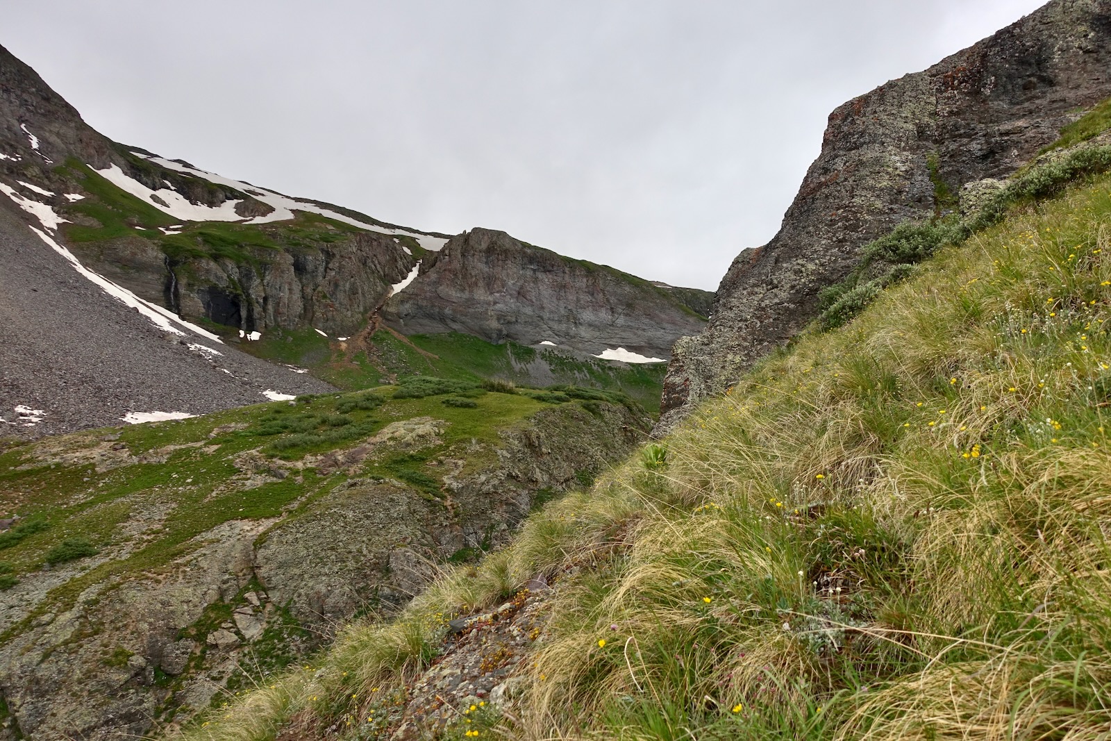
The grade steepened significantly for the next 300 feet. We let a herd of two dozen elk guide us. We smelled the animals and happened upon their beds before they showed themselves. (THW, photo)

Below, we are following in the footsteps of the elk.

The path I am about to stumble on may look like a social trail but we saw no evidence of humans in the gulch and suspect is it a game trail. (THW, photo)

We got our first visual of the saddle. Wisps of clouds descended and dissolved intermittently. While we were a month further into the summer than on our first climb in June, 2012, the snowfield at the head of the basin was considerably larger.

We arrived on a broad bench at 12,100 feet. We threaded between gigantic boulders that tumbled from the cliffs above. Wildflowers were clustered at the bases of the warm, protective rock--mountain bluebells, king's crown, old man of the mountain, alpine clover, and alpine avens. Plan to spend a few extra moments in this sparkling park.
The final fiery renaissance in the San Juan volcanic field was a succession of
massive volcanic explosions which racked the range from about 35 to 28 million years ago. The San Juan formations seen throughout this hike were carved from the thick blanket of gray volcanic rock which smothered the San Juan uplift. (THW, photo) 

Commodore Gulch is enclosed by two cliff-forming ridges. Below, I'm pointing to a deer herd grazing on the steep slopes of the ridge running southeast from Point 13,217'. We shared the upper recesses of the basin with the elk herd seen earlier. A ptarmigan was camouflaged in summer colors. (THW, photo)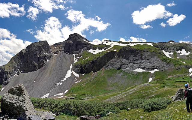

The southeast ridge of T7 is the most direct line to the peak. Our route detours through the basin to avoid the jagged complexity of the ridgetop.

At 12,100 feet, 2.4 miles, cross to the southwest side of the gulch.

In 2012, the stream was flowing under snow bridges as well. Therefore, we mounted the small knob (image center-left) before returning to the floor of the gulch and climbing the throat all the way to the saddle. We went straight up the snowfield at the head of the basin (traction recommended). That was a 7.5 mile roundtrip hike.

In July 2025, the snowfields and bridges were so extensive, we worked the southwest slopes and ridge flowing from Point 13,217'. Our improvisation added one mile but it also extended the tour through this heavenly basin. Waterfalls cascaded down every crack and crevice.

We ascended intuitively, following the natural contours of the landscape. There were three of us on this hike and it was fun to toss around route options and reach consensus.

Considering how extensive the snowfields were we weren't sure at this point whether we'd even make the peak. We turned west at 12,500 feet. 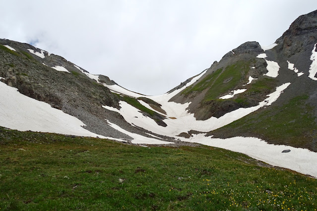

A mine shaft is a clear marker for this location. We poked into the head-high shaft that receded into darkness. (Exploring mines is not recommended by Earthline!) We spotted a narrow green ramp going over the roof of the mine that would take us to the next level. This was our lucky day. 

The ramp lifted us into somewhat chaotic territory with patches of snow and small cliffbands.

It was simple enough to engage the southeast ridge of Point 13,217'. We topped the unranked summit at 3.2 miles.

You can descend northeast from Point 13,217' directly to the saddle where the mellow climb to T7 awaits. (THW, photo)

Since a couple of us were veteran Imogene Pass Run racers, just for fun we made a short side trip west to the pass.

One member in our group dashed up to Point 13,365', "Fort Peabody," site of the highest historical military post in the United States.

Imogene Pass, elevation 13,114 feet, 3.6 miles, is spectacular.
It is the highest vehicular mountain pass in the San Juan Mountains, and
the second highest in Colorado. The Telluride side of Imogene Pass was
closed for the summer of 2025. According to San Miguel County
Road and Bridge Department, a retaining wall gave way causing erosion along a section where the road is blasted into the cliff.

To reach T7 we cut west of Point 13,217'.

It was an easy but bigger drop than we anticipated into the 12,860-foot saddle (LiDAR, 12,886 feet). This image looks back on Point 13,217' and the saddle from the southwest slope of T7.

If your timing is good, the ridge will be covered in alpine phlox. It emits a sensational perfume guaranteed to double your energy.

The grade is moderately steep, footing is good, and there's nothing to dodge. (THW, photo)

We stopped to photograph a big chunk of quartz crystals. Our geologist friend, John Bregar, has seen quartz crystal masses in several places around Silverton. He noted, as volcanic rocks spewed out of the various calderas cooled down, they shrank and cracked and formed vugs (cavities). Hydrothermal fluids (hot mineralized water) carrying lots of silicon dioxide deposited large quartz crystals in the cavities where they formed slowly over time. (THW, photo)

I walked along the southeast edge simply because the cliffs were so interesting. This area looks like a mix of welded ash-flow tuff and rhyolite.

Nearing the crest, the peaks to the south became apparent. In this image Ptarmigan Lake is nestled east of Telluride Peak followed by Point 13,510'.

A hiker crests the endless softly rounded summit at 13,359 feet.

Arrive on T7 at 4.6 miles. The peak cairn and register are not quite on the highest point of the curve so be sure to take that in. The vista is surprisingly comprehensive--see all the San Juan monsters surrounding you. This image looks northwest to the bodacious peaks in the Mount Sneffels Wilderness. (THW, photo)

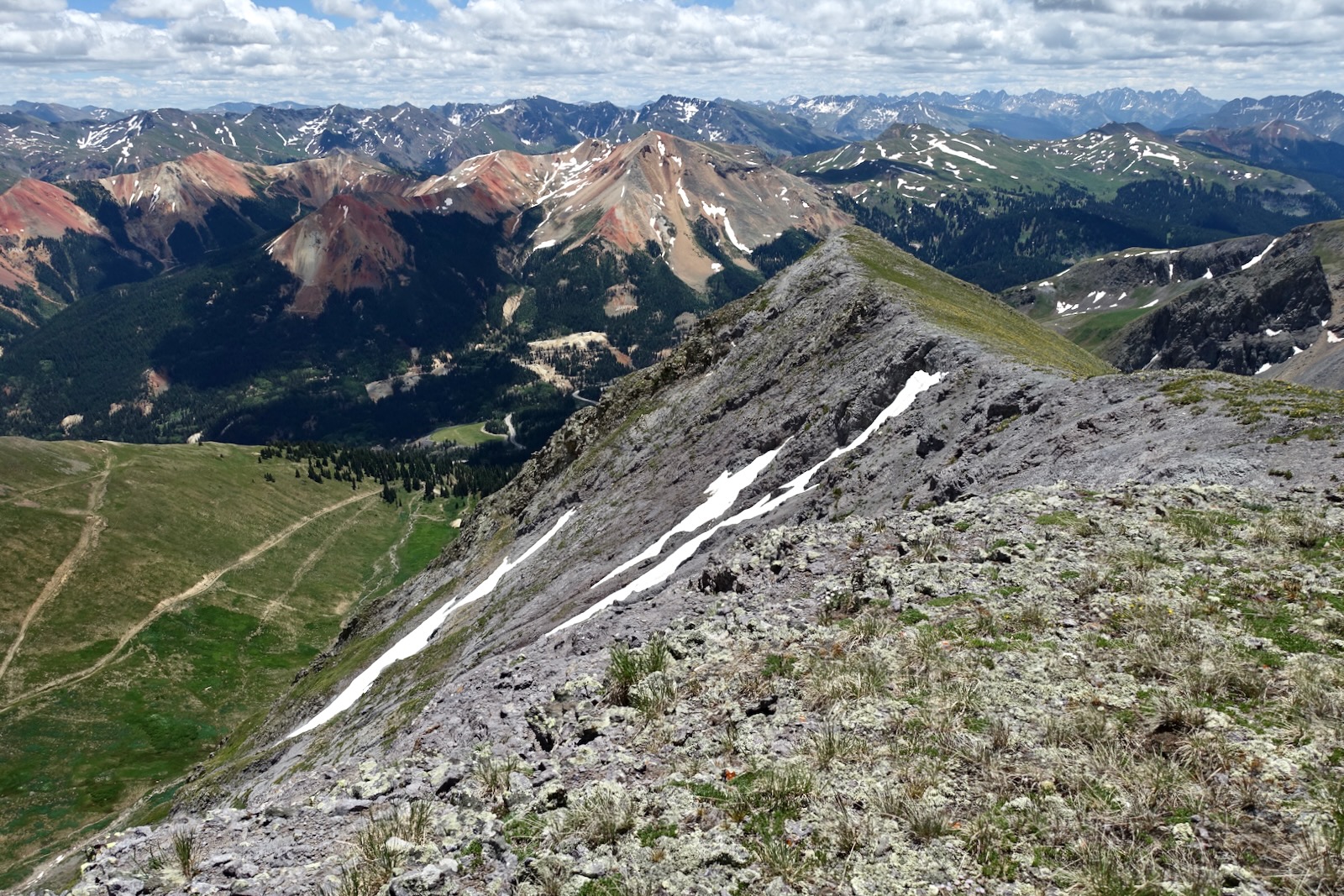
Look over Peak 13,315' (T8), another big bruiser, to see Coxcomb, Wetterhorn, and Uncompahgre peaks.

In 2011, I climbed T8, a story for another day, and captured this image of the north ridge of T7. We gave considerable thought to spanning between the two. However, when we got into the shared saddle it looked sketchier than it
did from afar, weather was closing in, and we abandoned the idea. I do
know the traverse between the peaks has been done.


Sastrugi and somewhat soft snow helped at first but the snow firmed up and we had to be deliberate.

This final image was snapped at the top of the pack trail. Both the singletrack and the old road functioned as assistants for transporting us into Commodore Gulch. Exploration off-trail is always a gamble, inevitably full of surprises and varied outcomes. Commodore Gulch was nothing short of glorious.

No comments:
Post a Comment