Travel: In a 4WD, high-clearance vehicle with sturdy tires, from Durango drive 47 miles to Silverton. Turn northeast and proceed up Greene Street, the main drag, to the north end of town. Zero-out your trip meter as you make a soft right onto San Juan CR 2. The dirt road is good at first but degenerates to a slow, rocky surface. At 12 miles pass through Animas Forks, an abandoned mining town founded in 1880, elevation 11,160 feet. Bear left at a sign for California Gulch, staying on the main road. (It eventually goes over California Pass into Poughkeepsie Gulch and rejoins the Alpine Loop.) Cross the West Fork of the Animas River at 12.2 miles. The annoying rocky road passes by the magnificent Frisco-Bagley Mill. Turn left into Placer Gulch at a signed junction at 13.3 miles. Going south, cross the West Fork once again. Large mining ruins are plentiful in an idyllic, flowerful basin. There is a short narrow shelf. Park at the Gold Prince Mine, elevation 12,200 feet, at 15.2 miles. Allow 2:00 to 2:30 from Durango.
Distance and Elevation Gain: 5 miles; 2,400 feet of climbing
Time: 4:00 to 5:00
Difficulty: Off-trail; navigation moderate; ridge loop is Class 2+ with mild exposure; the spur to Hurricane Peak is Class 3+ with moderate exposure
Map: Handies Peak, Colorado 7.5' USGS Quad
Latest Date Hiked: August 2, 2017
Quote: Nature is an infinite sphere of which the center is everywhere and the circumference nowhere.
Blaise Pascal, b. 1623
Hikers climb the approach ridge to Hurricane Peak, surrounded and engulfed by mountainous topography. (THW, photo)

Route: This loop and stem explores the ridge that extends northwest from Point 13,270' over Hanson Peak, terminating at Hurricane Peak. Return to the junction with a northeast flowing ridge and from there climb California Mountain. While the loop portion of the hike is described clockwise, it spins equally well either way. From the parking area in Placer Gulch follow the 4WD road as it ascends toward Treasurer Pass. Leave the road (The hike is off-trail from this point.) and gain the saddle northeast of Point 13,270'. Follow the ridge around to the east side of California Mountain and plunge back to the start. The stem to Hurricane Peak is recommended for experienced scramblers.

From the parking pullout at the Gold Prince Mine, elevation 12,200 feet, walk south crossing the creek draining Placer Gulch. This road is lightly traveled by four-wheelers going over Treasure Pass and down into Picayne Gulch. I have seen a large domestic sheep herd in this basin. (THW, photo)

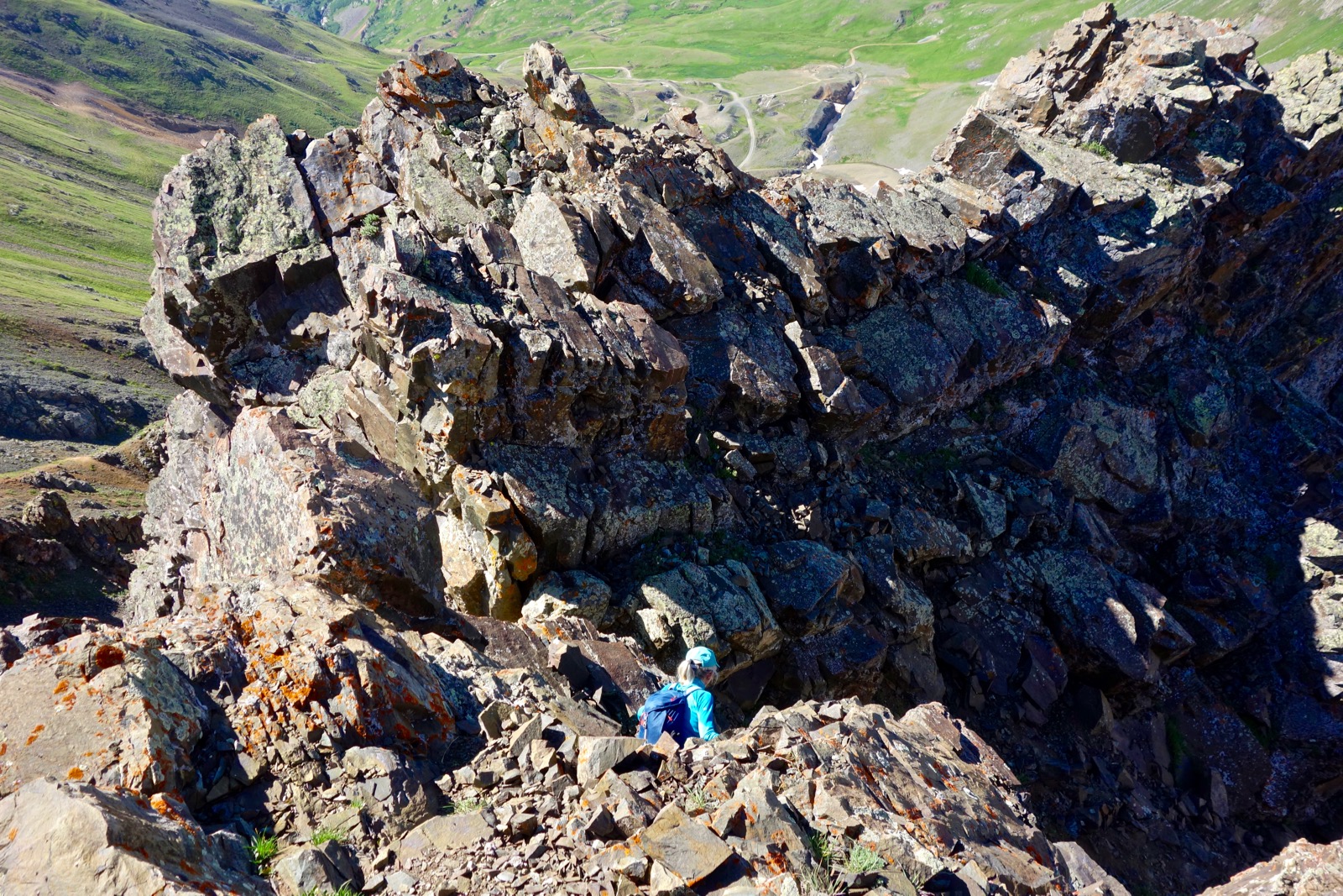
Leave the road at 0.8 mile, 12,660 feet, and make for the 12,860 foot saddle northeast of Point 13,270', seen below. It is a straight-forward, moderate pitch riddled with animal trails. (THW, photo)

Gain the saddle at one mile and begin the 400 foot climb to the prominence. Alpine flowers transition to stone. The spine nicks down to two feet and drops away on both sides. There is a Class 2+ scramble on good rock over a short, entertaining knife-edge.

The trek up the relatively broad summit block is through explosive San Juan volcanics. This photo looks back on Placer Gulch, image-left, the track over Treasure Pass, Treasure Peak, and Point 13,075', image-right. On the eastern horizon are Coxcomb Peak, Wetterhorn Peak, Uncompahgre Peak, and Handies Peak. (THW, photo)

The first prominence, Point 13,270', is a nondescript small rounded knob with an exceptional view. Below to the southwest is Eureka Gulch. Framing the basin are Emery Peak and Bonita Peak. Off in the distance Golden Horn is unmistakable.

The ridge descent is narrow and playful.

Littering the 13,100 foot saddle south of Hanson Peak are mining foundations and debris. The earth is pulverized, the rock red. Locate a trail fragment on the south side of the saddle for the steep and loose scree shot back to the ridgeline.

Crest Hanson Peak at 1.9 miles. While three mountains are named on this circuit, this is the only prominence that meets the 300 foot relief requirement to be ranked (No. 287). Take in the uninterrupted view from the roomy summit. Just left of this cluster of hikers is Point 13,270'. Right, is Dome Mountain, 13,370'. (THW, photo)

Notice on the map above that the route to Hurricane Peak leaves the loop at the "Vertex," elevation 13,380 feet, 2.2 miles. The 0.7 mile spur to Hurricane is exposed Class 3+. For those opting out, stay on the loop to California Mountain, pictured.

To summit Hurricane, from the Vertex head west to Point 13,306', shown.

Immediately west of the high point the ridge drops roughly 80 feet. Either descend the gully or the spine of a near-vertical outcrop. I typically descend via the gully and climb back on the ridge. Below, a friend is downclimbing into the gully entrance. Test all holds.
This image looks up at the initial 25 foot drop.

The gully is steep and exposed. (THW, photo)

Return to the ridge at first opportunity. (THW, photo)

While climbing Hurricane vehicles are audible and visible on California Pass.

Watch for purple wallflowers, unique to the Silverton region, on the tundra-covered approach to Hurricane. Saddle elevation is 13,180 feet.

Crest Hurricane Peak at 2.9 miles. The small stone crown provides a superb vantage point. Nader's SummitPost describes the exceptional topography of the mountain. As he notes, Hurricane is the source of four rivers that flow through the valleys below: Poughkeepsie Gulch and the Uncompahgre River to the north; California Gulch and the West Fork of the Animas River to the northeast; Eureka Gulch and the South Fork of the Animas River to the southeast; and Cement Creek to the southwest. See Nader's post for alternative approaches to Hurricane Peak from any of the four valleys.
Hurricane Pass is tucked between the peak and Brown Mountain, the prominent ridge on the west. It points north to Abrams Mountain, an arresting landscape feature above the town of Ouray. Hurricane is framed by spectacularly carmine peaks on either side--the Red Mountains and California Mountain.


From the Vertex at 3.6 miles head northeast toward California Mountain favoring the right side of the ridge. Broken, chipped rock with sharp edges is seriously black, brilliant red, and mustard-colored. (THW, photo)

Past the saddle, elevation 12,940 feet, tread on a red fold of stone. The walking platform is good where the ridge tapers.

Summit California Mountain at 4.1 miles. Judging from the peak register, hikers rarely enjoy this red experience. This image looks back on Hanson Peak, the Vertex, Point 13,306', Hurricane Peak, and California Pass. (THW, photo)

To return, descend northeast on the ridge. After losing 100 feet the scree transitions to tundra. Pick any appealing line to plunge into Placer Gulch. Once, we walked out to Point 13,184' and descended on its east ridge. Mid-summer, the hillside is a continuous flower garden. Up high, rosy and hybridized paintbrush dominate with patches of queen's crown. Masses of sunny-yellow orange sneezeweed brighten the runout zone. (THW, photo)

Blue sky, white clouds, red mountain, green tundra. Besides capturing the elemental colors of the day, this image is a good indicator of the counterclockwise route to California Mountain.

This is a relatively short hike leaving time to explore mine ruins. Below is the sign for California Gulch in the ghost town of Animas Forks.

The Frisco-Bagley Mill sits beside the road in California Gulch. It was stabilized in 2013 by local residents.

3 comments:
Hi Debra, thank you for sharing your knowledge of all these great hikes! I'm planning to do this one in August and was wondering if you'd be willing to share a GPX file for this route? Thanks so much, Dan
I saved a guys life ob Hurricane Peak. He was riding full tilt up the gentle slope side. I stopped him before he went flying over the edge.
Oh my goodness! He is so fortunate you were there when he needed you most. Good job. Debra
Post a Comment