Travel: From the US 160/550 intersection in Durango, travel 11.0 miles west on US 160 to Hesperus. Turn north on La Plata Canyon Road, CR 124. Zero-out your trip meter. After passing the hamlet of Mayday, the road turns to smooth dirt at 4.6 miles. There are several established campgrounds in this area. In 8.5 miles the roadbed deteriorates with sharp, sizable rocks. At 12.0 miles the road splits. Continue on the left fork another two miles on FSR 571 to the Kennebec Pass TH in a high clearance, 4WD vehicle with sturdy tires. Allow 1:00 to 1:30 from Durango. If you do not have 4WD, you can still climb these peaks by approaching from the east, starting at the Junction Creek Road/Colorado Trail TH. See Cumberland Mountain for driving and hiking instructions.
Distance and Elevation Gain:
Kennebec Peak: 2.8 miles, 525 feet
Olga Little Mountain from Kennebec Peak: 4.7 miles, 1,300 feet
Olga Little Mountain from Kennebec Pass Trailhead: 4.2 miles, 850 feet
Time: 1:30 to 2:30 for Kennebec Peak; 3:30 to 5:00 for both
Difficulty: Trail, off-trail; navigation moderate; mild exposure and Class 2+ on the southwest ridge of Olga Little Mountain
Maps: La Plata; Monument Hill, Colorado 7.5' Quads
Latest Date Hiked: July, 5 2020
Historical Note: Olga Little, a German immigrant, lived on a ranch in Mayday with her husband. From 1909 to 1949 she was a packer, using her string of burros to carry in supplies to men working at all of the La Plata mines. While Olga regularly hauled out ore, she once saved 18 starving men by having them hang onto her burros' tails while walking through a blizzard to safety.
Quote: To you, Olga Little of Hesperus, Colorado! Wherever mining men gather, and wherever tales are told of the days of gold and silver in this great State of Colorado, a part of that glory will always land upon your name. This Is Your Life, TV show with Ralph Edwards, 1958
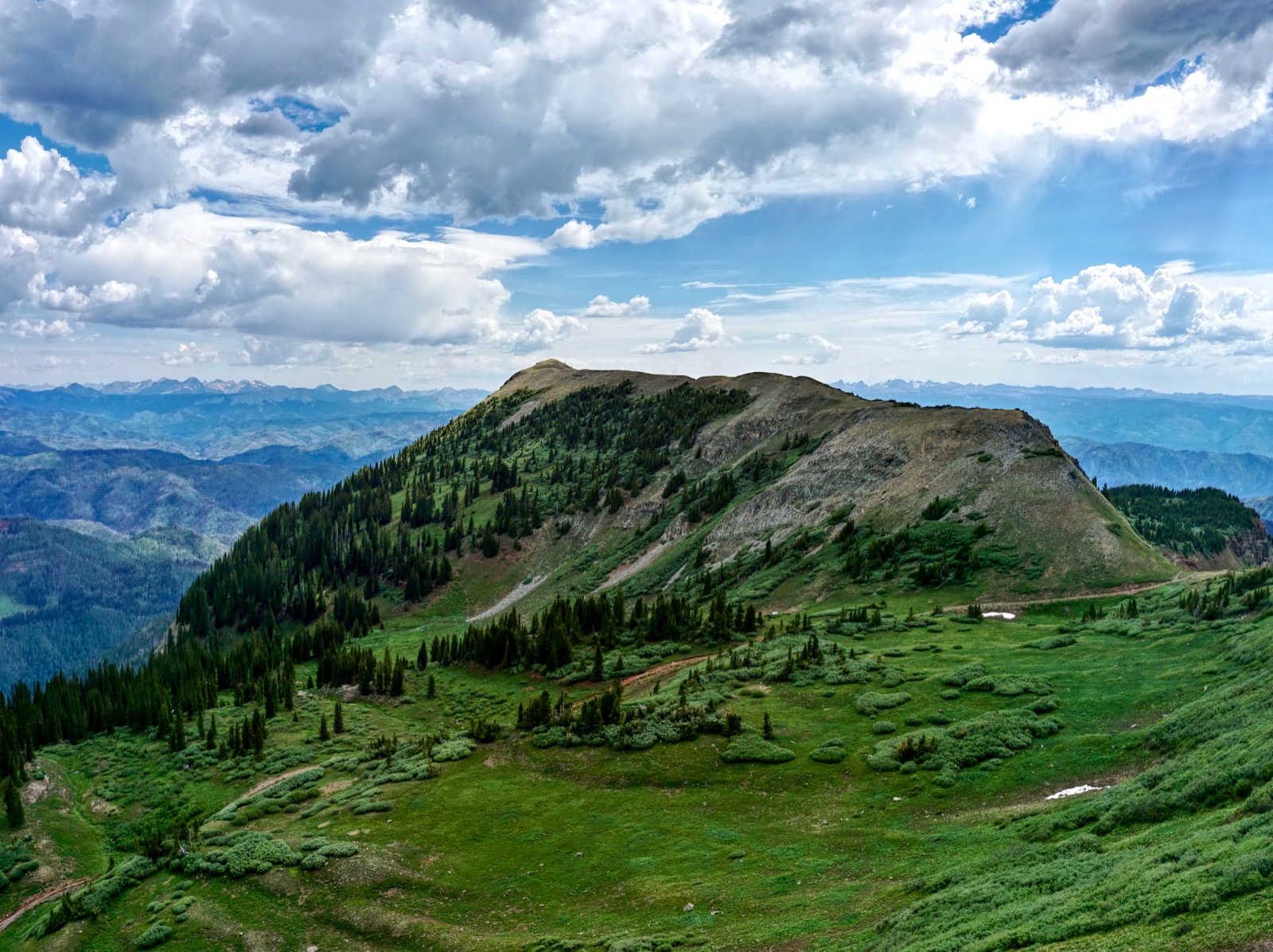
Kennebec Peak and Olga Little Mountain (image-right) from Cumberland Mountain. (Thomas Holt Ward, photo)

Route: To reach Kennebec Peak from the trailhead, elevation 11,600 feet, walk east to Kennebec Pass. Climb north-northeast to the crest of the ridge. To add Olga Little Mountain, descend southeast to intersect the southwest ridge. For Olga Little alone, from the pass hike northeast to the southwest ridge. Back at the trailhead, you can tack on Cumberland Mountain and/or The Notch if you wish.

Kennebec Peak
From the trailhead, walk east 0.7 mile on the Colorado Trail to Kennebec Pass, 11,740 feet (image-right), the low point between Cumberland Mountain and Kennebec Peak. The terrain is a mix of willows and an astonishing array of wildflowers mid-summer, including a neon mix of Indian paintbrush and alluring queen's crown. This image was shot from the northwest ridge of Cumberland Mountain. (THW, photo)
Upon reaching the pass, shown below, turn left/north and begin the 15 to 30 minute, 0.7 mile climb to the peak. This image was captured from the east ridge of Cumberland Mountain.

The initial 200 feet is rather steep, off-trail, requiring a little effort.

Follow a social trail west of the ridge through a brief, rocky section. Alternatively, scramble directly on the ridgetop.

Back on the curve-top, experience the euphoria of a simple walk up the broad ridge to the high point.

Be sure to continue a few paces past the summit to a stone bivouac. Look north across folds of green velvet. Engineer Mountain is just right of center. The San Juan Arc extends from Lone Cone to Mountain View Crest.
(Chris Blackshear, photo)

Swing around for an expansive display of La Plata's west block peaks. Sharkstooth Peak is jutting above Indian Trail Ridge, image-right.

The image below was shot from the same location on a monsoonal morning in August, 2019. From the left are: Mount Moss, Lavender Peak, Hesperus Mountain, and Centennial Peak. (THW, photo)

Olga Little Mountain from Kennebec Peak
Return to the trailhead as you came unless you are continuing on to Olga Little Mountain. This diminutive bump is not ranked and rises only 146 feet from its saddle. Ironically, it is more troublesome to visit than many higher peaks. I climbed it from curiosity and in honor of its brave and hearty namesake, savior of miners. Olga Little resides due east.

From the summit, walk a few paces back to the south before beginning your grassy plunge to 11,600 feet.

Walk east to intersect Olga's southwest ridge at 11,520 feet. The crest is shown on the left. Once the snow is gone, willow bashing is unavoidable. Read on for a description of the ridge running out to the peak and for the best return route.

Olga Little Mountain from Kennebec Pass Trailhead

It’s job done, the wildcat trail disappears on a broad platform in corn husk lily heaven. Take stock of your location and consider your plan for reaching the southwest ridge of Olga Little Mountain. While the ridge is only 0.6 mile from here, stands of willows make the going tough and the way obscure.

The narrow, willow-free spur running out to Olga Little Mountain begins at 11,520 feet and extends for 0.6 mile. The ridge has a wild feel and will challenge most hikers. I like to picture Olga, small but mighty, dodging trees and balancing confidently on chopped gray rocks. (THW, photo)

Descend for 0.4 mile to a saddle at 11,280 feet. Watch your footing and stay right on the thin crest. If you must bypass an obstacle return immediately to the razorback. The trees were trimmed since I first visited this peak and I expect elk hunters are to thank for enhancing the passage. Judging from all the scat, elk are plentiful. (THW, photo)

There are occasional views of the peak. (THW, photo)

Climb down through brick-colored blocks in the Cutler Formation. If your timing is good, blooming red columbine compliments the rock. Once you bottom out there is only 0.2 mile remaining with 146 feet of vertical. It is best to track along a few feet off the spine on the north side. Climb the summit blocks from the north as well.
Top out on the linear summit at 2.1 miles. Judging from the peak register, only a couple of parties each year visit the red mountain and they are either elk hunting or paying homage to Colorado’s only female jack packer. Look out over the familiar La Plata lineup and then circle around to see the San Miguel Mountains, Grenadier Range, and Needle Mountains. Standing on the rim at Fort Lewis College there’s a straight visual up Junction Creek to Olga Little Mountain. Now you may reverse your gaze and see Durango to the southwest. This image, shot on the peak, shows Lewis Mountain, Cumberland Mountain, and Kennebec Peak. (THW, photo)

Additional Hikes from Kennebec Pass
If you are excited for more, two wonderful add-on options follow. Climb Cumberland Mountain, 12,388', shown. Intersect the northwest ridge at about 11,680 feet and climb for 0.6 mile and 710 feet to the top. A sporadic social trail will assist. (THW, photo)

Alternatively, walk southeast on the 4WD road from the trailhead to The Notch. It is 0.8 mile each way and adds 400 feet of climbing. The Notch was blown out by miners; it is located between Cumberland Mountain and Snowstorm Peak.

Note: We tried to climb Cumberland's southwest ridge from The Notch. The first section is an ultra fun knife. Obstacles became increasingly difficult with an impassible one 150 feet below the summit. (EJB, photo)

If you are gnarly enough to drive to Kennebec Pass TH, muster the moxie to walk to Kennebec Peak. It is the easiest of all the peaks in the La Plata Mountains and the view is unparalleled.
The La Platas enjoyed copious snow in the spring of 2014, so waterfalls were prolific along the road and the ground spongy. Early flowers noted: senecio, marsh marigold, alpine parsley, purple fringe, candy tuft, dwarf phlox, king's crown, kitten tails, snowball saxifrage, glacier lily, Fendler's sandwort, spring beauty, Brandegee's clover, fairy candelabra, sky pilot, larkspur, and pussytoes. As a friend said, "Snow buttercups have been out of the snow for no more than 15 minutes."
2 comments:
Is there an official map that labels 12101' as Kennebec Pk, or is that just a 'Locals' reference?
Peak 12,101' has not been officially designated Kennebec Peak by USGS. The name is in widespread use. For instance, Google Maps calls it Kennebec Peak.
Post a Comment