Travel: From Durango drive 47 miles to Silverton on U.S. Route 550. Turn northeast and proceed up Greene Street, the main drag, to the north end of town. Zero-out your trip meter as you make a soft right onto San Juan CR 2. At 2.0 miles, turn right on San Juan CR 21 just before the Mayflower Gold Mill. Cross the Animas River on a bridge and head up into Arrastra Basin. At 2.8 miles, stay left where CR 55 branches right. Park at 3.2 miles where the road from Little Giant Basin comes in on the left at 10,160 feet. 2WD vehicles with sturdy tires should reach this point but don't attempt to go further up Arrastra. Allow 1:20 from Durango. If your destination is Silver Lake, in a 4WD vehicle, park before the final switchback to the Mayflower Mine at 10,600 feet.
Distance and Elevation Gain: 7.6 miles; 3,900 feet of climbing
Time: 5:30 to 7:00
Difficulty: Trail, off-trail; navigation somewhat challenging; Class 2+ with mild exposure
Map: Howardsville, Colorado 7.5 Quad
Latest Date Hiked: September 16, 2016
Poem:
And when the throng of eager men--
Men of heroic mold and true--
Wrought mines that silver might be had
They builded better than they knew--
These men now gone.
Unknown poet, Silverton Standard, 1903
Hikers nearing Pt. 13,045' first climbed Little Giant Peak, image-right, and then traversed the alpine ridge of King Solomon Mountain.

Route: From the parking pullout at 10,160 feet, walk south up the road into Arrastra Gulch. The track does a major switchback and then transitions to the Silver Lake Trail at Mayflower Mine. Scale the headwall via the hand cable route. Shortly before Silver Lake, locate an historic trail up the west slope of Little Giant Peak. From the crest, go east, swing around the head of Little Giant Basin and, off-trail, climb King Solomon Mountain. Continue over the next two prominences before taking the northwest ridge back to the road emerging from Little Giant Basin. Those who wish to avoid a steep, scrabbly descent from King Solomon may return to Dives Basin Pass and take the blue-line trail into Little Giant Basin.

The warmup in Arrastra Gulch is a walk through Silverton's earliest mining history. In 1870, the Little Giant gold vein was found below the Arrastra headwall, shown. This resulted in the first profitable hardrock mine in the Silverton area. The ore was relayed by aerial tramway and pulverized in an arrastra, a circular pit with a stone floor. Flat stones were connected to a center capstan. A draft animal provided power at the end of a long beam dragging the stones and crushing the ore. Water and mercury were added which amalgamated with the gold as it was freed.
The hand cable route is left of the Arrastra Creek spillover, image-center.
Steel Mayflower Tramway towers were protected by snow slide splitters designed to dissipate the force of avalanches. Men rode the tram to work as did women employed in the kitchen and commissary. Even stealthy children hitched rides, though this practice was forbidden by management.
The road makes a major switchback at 0.5 mile, 10,600 feet. Park here if you are simply doing an out-and-back to Silver Lake.

The road ends at the Mayflower Mine, 11,140 feet, 1.4 miles into the hike. In 1929, a five-story boarding house was built adjacent to the mine. Photos as recent as 1991 show a collection of buildings at the site but now only a rusty assortment of debris remain and the mine portal has been sealed with cement. Extracted ore was sent via tram to the Mayflower Gold Mill located north of the Animas River on CR 2.
The mill operated from 1930 to 1991, the longest running mill in the history of the San Juan Mountains. The mill produced 1,940,100 ounces of gold; 30,000,000 ounces of silver; and 1,000,000 tons of combined base metals. In 2,000, the mill was designated a National Historic Landmark. It is owned by the San Juan County Historical Society and is open for self-guided tours in the summer.
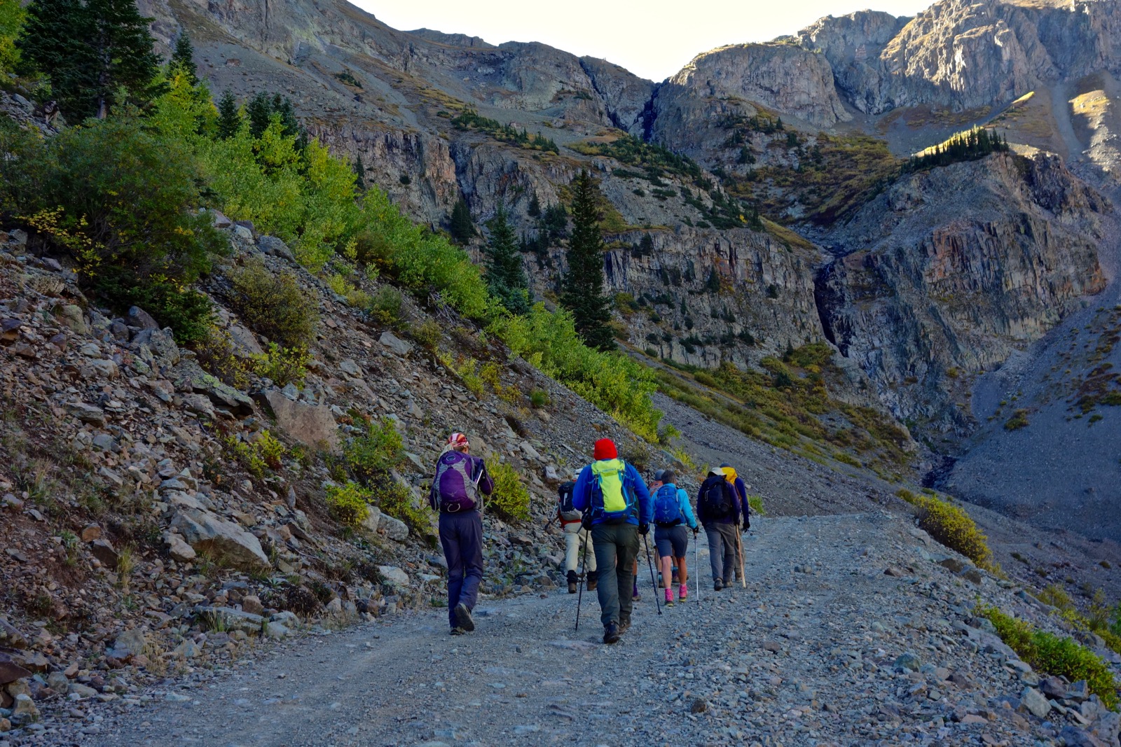
In the image below, hikers are transitioning onto the Silver Lake Trail. The footpath follows an old wagon road and thus has a generous platform in spite of its location on a sliding scree slope.

The path makes four sharp switchbacks up the final 400 feet to the base of the upper cliff where the hand cable route ensues. The abandoned track has washed away and hikers must scale a rock outcrop. Two choices are presented. The low route, shown, has a few exposed steps.

The high route is up against the wall. Stone holds are good but an old steel cable is anchored if you want to use it, pictured. Both routes join and enter a center chute along with the cable. It is a short, enjoyable scramble to the top of the headwall.

Below, hikers are standing at the top of the cable route at 2.0 miles, 11,800 feet. West is Hazelton Mountain on the divide between Arrastra Basin and Blair Gulch. (THW, photo)

Now in Arrastra Basin proper, you will connect with the old trail again. It rises gradually to Silver Lake, 12,186 feet, following Arrastra Creek. It is a short and worthy diversion to Silver Lake to scout around in the remains of the Silver Lake Mill and stamp banks, Iowa Mill boilers and steam engines, and Royal Tiger Mine. On my last visit in 2005, I came across a fascinating array of every day artifacts strewn amongst ore cars, the boiler building, machine shop, and boarding house.
In 1876 prospectors began looking to the more isolated areas around Arrastra Gulch and made the dangerous ascent into the glacially carved "Silver Lake Basin." In 1890, mule trains packed in thousands of board feet of lumber, tons of hardware and machinery, and basic living necessities. They assembled the largest surface plant and mill in the county, processing 300 tons of ore each day. By 1900, 300 men were living and working at the Silver Lake Mine. (THW, photo)

Before leaving the Silver Lake Trail and making for Little Giant Peak, visually locate the subtle old mining path doing a rising traverse to the north. It is essential to find this assist up the steep, west-facing hillside. At about 2.5 miles, 12,160 feet, head east a short distance and then go north on a minor bench. Here, you will find the trail which does a switchback up a patch of grey rock, shown just left of image-center.

The thin platform maintains a steady, pleasant grade. Watch for switchbacks. At 13,000 feet, there is a prospect. Hazard! Boards are strewn about with nails sticking straight up. This bench is a good place to pause and view the ghost town at Silver Lake. From the lake, it is possible to follow a mining track to the pack trail that goes over "Deer Park Pass," image-center. South of the pass is Pt. 13,409', and north is Kendall Peak. (THW, photo)

Gain Little Giant's north ridge, at 13,120 feet. The route stays on the west side of the colorful, lumpy ridge comprised of San Juan volcanics. Quartz crystals are plentiful and so are historic pipes. The image below looks back on hikers regaining the north ridge just prior to summiting. (THW, photo)

Crest Little Giant at 3.5 miles after 3,250 feet of vertical. The view is remarkable because the peak sits at the apex of three basins: Arrastra is west; Little Giant is north; and Dives is southeast. The north face is precipitous. This image looks south with Highland Mary Lakes on the Continental Divide platform and Rio Grande Pyramid and the Grenadier Range on the horizon. (THW, photo)

Looking east from the summit, King Solomon Mountain straddles the divide between Little Giant Basin flowing down to the left and Cunningham Creek. Dives Basin is off to the right and the pass is between the peaks, shown in front of my hiking partner. Unmistakable Half Peak is closer than it looks.

There are two ways to descend the mountain. For the standard route, locate a social trail just to the south side of the east ridge. Or, stay on the spine and scramble down the pinched, somewhat exposed ridge, pictured. Both routes meet at a divot at 13,160 feet where a second choice is presented. Again, the standard route skirts the ridgeline on its south. The knife ridge depicted in purple on my map, is Class 2+ on good, "Skip to My Lou" rock as one seasoned friend described. (THW, photo)

At 13,000 feet, 3.9 miles, the social trail makes a sharp left on the Dives Basin Trail which bears north to the Little Giant-King Solomon saddle, " Dives Basin Pass," shown, at 12,940 feet, 4.0 miles. Be watchful; I have spotted a fox and golden eagle in this area.
Note: Hikers who wish to avoid the not-so-pleasurable segment of King Solomon's northwest ridge should return to this pass and get on the excellent pack trail that descends into Little Giant Basin and joins the road, the blue-line route on my map. Frankly, the most common and easiest route up both Little Giant and King Solomon is to drive into the basin and park at 11,440 feet. I have been down this trail several times and mid-summer, the wildflowers are exuberant and glorious. Mining began in Little Giant Basin in 1879. While walking down the road, you will pass the Big Giant Mill and tram station and the remains of the Contention Tramway.

This image was shot from the initial start up King Solomon Mountain. It looks back on Dives Basin Trail and Pass, and the alternative east ridge descent from Little Giant Peak

Leave the Little Giant Basin trail and scramble up the solid rock staircase on the southwest ridge of King Solomon.

Give up about 40 feet and ascend again on the beautiful and playful wildcat path to the south hump of the summit ridge at 4.2 miles, just shy of 13,220 feet. 

King Solomon Mountain has three prominences; the 0.1 mile-long summit ridge is the collective highpoint. It has two knobs separated by a narrow ridge. It is hard to say which rise is taller but the summit register is located on the north hump, shown. Pt. 13,185' is left of the hikers.

This image looks back on the south knob from the official summit. It is knife-like between the humps but the rock is good. If your goal is to simply crest King Solomon Mountain, this is your turn-around. If you are a ridge purist and want to visit two more unranked prominences, keep going. (THW, photo)

The mile-long unobstructed ridge connecting the three crests is one of the finest in the San Juan Mountains. Walking sky high on a mix of tundra and stone is blissful. Reach the broad eminence of Pt. 13,185' at at 4.7 miles. From here we have seen mountain goats high on the east slope of Pt. 13,045', image-right. (THW, photo)

Cunningham Gulch is the significant drainage to the east. The Old Hundred Boarding House clings remarkably to the precipitous west slope of Galena Mountain.

From Pt. 13,045', the ridge steps down nicely to 12,800 feet where it goes over an outcrop, shown. The Animas River valley is abruptly below.

The ridge stops being fun but it is not dangerous. The next 850 feet of descent is tedious and requires patience. Rock is sharp and loose and sections are at the angle of repose giving way under foot. This image shows the contact between the talus and treeline on the northwest ridge.

At 11,950 feet, tundra resumes. Stay on the softly rounded ridge, bearing northwest. You are home free now.

This route has its virtues and stands of aspen adorn the well-spaced, pleasant conifer forest.

At 11,000 feet we intentionally leaned left/west to connect with the Little Giant Basin Road at 6.5 miles. However, you could stay on the ridge to 10,600 feet as indicated on the map above. Note that this is the last opportunity to meet up with the road which is the only direct shot to your vehicle. We crossed under the Contention Tramway just before reaching the road. (THW, photo)

6 comments:
Someone has tidied up all the boards with nails. They are now stacked near the mine pit. Excellent day to little giant. Remember...the 21st of September...
Dave, Thanks for this update and for your observations. You are really covering the territory this autumn. Equinox tomorrow! Debra
Always a favorite hike...was back again on Friday Aug 11. The trail seems to be very infrequently used...while at the same time degraded in several spots. I think Little Giant is an appropriate name. It doesn't have the wide footprint as a Sultan or Kendall but the thing is deceptively tall at approximately 13.5. Tundra all over the San Juans is very brown but the columbine is always reliable around Silver.
Thanks for the update on trail conditions. You are reminding me how much I adore this hike. It's been way too long! So glad you got out on those magnificent mountains. And yes, the columbine are having a good year in 2023. Deb
Just did this hike last week. Your write up was so helpful. Had both basins to ourselves other some 4 wheelers that were buzzing around the silver lake side.
This is one of my favorite hikes in the Silverton area. I'm pleased you got up both mountains. They don't get a lot of company. Good job! Debra
Post a Comment