Thursday, August 31, 2017

Yellow Mountain South, 13,177', Via Waterfall Creek

Essence: A neglected but stellar hike to an unranked peak, subsidiary of Pilot Knob. Follow Waterfall Creek while stepping up through three basins nestled between Yellow Mountain to the southwest and Pilot Knob, V3, U S Grant Peak, and V4 on east. Don't dismiss this exceptional adventure just because it doesn't go to a legal summit.

As seen from Lizard Head Pass, Yellow Mountain owns the entire ridge left/northwest of Pilot Knob, shown on the right. Yellow Mountain North is the tallest summit at the left end of the ridge while Yellow Mountain South is the first highpoint left of Pilot Knob.


Travel: Ophir Pass Route: In a 4WD/HC vehicle, from Durango, drive north on US 550 about 47 miles to Silverton. Zero out your trip meter and continue north on 550 towards Ouray. The sign for Ophir Pass is at 4.8 miles. Make a left and go steeply downhill on San Juan CR 8. Cross Mineral Creek noting the sign, "Recommended HC 4WD." At spurs, stay on the main road as it narrows to a more obvious shelf. Most of the distance is a shelf road so take the highway route if you are squeamish. In places the track is no wider than the wheels. At 7.9 miles, make a switchback to the right, avoiding the left spur. Ophir Pass, at 9.1 miles, 11,789 feet, is situated between North and South Lookout Peaks. So much for the easy side. On the west, the road gets much steeper with big, sharp rocks, dangerous for ordinary tires. The sharp switchback at the end of the first traverse has a big hole. If there are upcoming vehicles, wait until the road clears at the switchback because the next mile is a no-pass zone. The narrow, rough, exposed shelf is etched into a talus slope. Thread between the pillars and soon enter the trees where travel improves. Reach the town of Ophir at 12.1 miles. Follow the main road as it turns. At 12.4 miles, make a hard left and park immediately. A plaque honoring the Utes, located in a small stand of trees, marks the trailhead. Allow 1:40 to 2:00 from Durango.

Ophir Pass Road is not for everybody and certainly not for every vehicle. It is fairly typical of 4WD passes in the San Juans...rough, exposed, and resplendent. For those who do it, the drive is a bonus feature.

Highway Route: Ophir is located east of Hwy 145. The turn-off is between Telluride and Lizard Head Pass. In Ophir, drive east on Granite Street to the trailhead described above.
Distance and Elevation Gain: It is 8.7 miles roundtrip with 3,550 feet of vertical to climb the peak. If you continue out the northwest ridge it is 10 miles with 4,000 feet of climbing.
Time: Peak only, 5:30 to 6:30; full tour, 6:30 to 8:00
Difficulty: Mining track, trail, off-trail; navigation moderate; mild exposure on optional trek northwest of peak
Map: Ophir, Colorado 7.5 Quad
Latest Date Hiked: August 31, 2017
Quote: The sound of colors is so definite that it would be hard to find anyone who would express bright yellow with base notes, or dark lake with the treble. Wassily Kandinsky, painter
Route: The hike begins on an abandoned road in the town of Ophir, a favorite for dog-walking locals. The road stays east of Waterfall Creek, pinching to a good trail all the way up into the first of three basins. This is where most people turn around; the route from there is essentially off-trail. Ascend twice more into ever loftier basins, all the while in the company of Waterfall Creek, before claiming the saddle southeast of Yellow Mountain South. From there, it is a simple hike to the peak followed by an optional out-and-back to elevation 12,700 feet. 

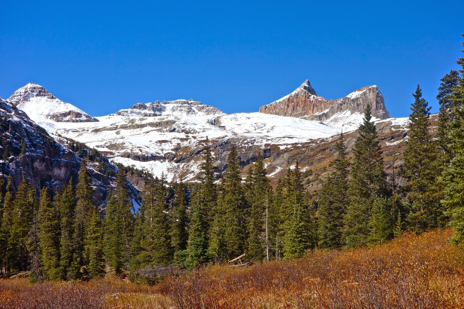
Trailhead 9,756' is marked by a small stand of trees and a plaque honoring the Ute People, "Whose feet once walked this valley..." Yellow Mountain takes up the entire high earthline.

Walk southeast downhill on a blocked-off track, passing below cabins and homes. Cross Howard Fork on a footbridge and regain the road. (In 2017, the bridge was washed out but the substitute makeshift crossing is fine.) Enjoy a pleasant uphill trek through an aspen/fir forest. While the course ambles, Yellow Mountain South is due south from the trailhead. At 0.5 mile, the road splits; take the left spur on the more established track. On our first trip we mistakenly went right to stay close to Waterfall Creek and got drenched by tangled masses of flora.

The terrain opens into a gorgeous valley, "Waterfall Gulch." The creek holds down the center.

At 1.0 mile, stay left and at 1.2 miles, come to mine ruins. The road ends. A trail goes through the ruins and into a clearing.  At 1.7 miles, cross a small ravine and then see the big wall that marks the south end of Waterfall Gulch. The first waterfall of the day plummets down through the trees. Meanwhile, Yellow Mountain is to the southwest, a verdant forest crawling up the sides of its water-stained walls, shown.

To breech the wall, the trail makes an ascending southeast traverse. The steepness of the no-nonsense track is tempered by good views of the waterfall. In autumn, geranium and fireweed leaves set the morning aflame.
(THW, photo)

At 2.3 miles, reach the cliffs at 11,200 feet. This is the contact between the Cutler Formation (below) and Telluride Conglomerate which makes up most of the cliffs. The trail makes an idyllic traverse along the base of the conglomerate mass and punches through a small opening in the rock. Top out at the north edge of what I'm calling Basin One.

Leave the trail and walk to the edge of the spectacular cascade at 2.5 miles, 11,300 feet. From the moment you enter the basin, the next challenge is visible. The second waterfall tumbles down a slit in the cliffs at the south end of the basin.

Return to the trail that emerged from the trees on the east side of Waterfall Creek. The further south you travel the sketchier the trail becomes. (In 2017, the track was more dependable.) Route finding is easy. Walk along the base of V3, 13,528 feet. Volcanic boulders have rolled from above onto her skirts and the valley floor. (THW, photo)

Stay left/east of Waterfall Creek. The white coating in the streambed is a precipitate of a hydrous aluminum sulfate called basaluminite. For an in-depth explanation of this phenomenon, see Rolling Mountain.

Go under the first set of cliffs left of the waterfall. It is a quick 200 foot climb into the next basin on a social trail.

Reach Basin Two at 3.2 miles, 11,840 feet. Walk past a peninsula, leaving trees behind for the remainder of the hike. (THW, photo)

A cataract plunges through the gorge.Two hikers stand on the precipitous edge of the peninsula.

Here's a shot from the peninsula looking up-basin. (THW, photo)

Start up the basin left of the creek. Watch for a wildcat trail at 12,000 feet going up a green slope on the right. Eventually it sputters out; just follow the rocky creek which has its own charms. The massive fin at the center of this image is actually the northface of Pilot Knob.

At 12,480 feet, 3.8 miles, enter Basin Three, the smallest of the set. For the first time, see Saddle 12,960' located at the base of Pilot Knob. Ascend the very steep green slope to the saddle at 4.2 miles.

Turn northwest and go over a yellow false summit to a second saddle. To scale the peak, shown, use a ramp on the right side of the ridge or climb straight up, my preferred route. Reach the peak at 4.4 miles.

Yellow South is an unranked summit (because there is less than 300 feet of vertical from its shared saddle with Pilot Knob). There is no register and very little evidence of traffic. However, the view is spectacular and so is the experience. Southwest are The Wilson's, Black Face, and Lizard Head. South is Grizzly Peak and San Miguel Peak. The V3, U S Grant Peak, V4 triplet, shown, is simply too wild for words. I have climbed U S Grant from Island Lake. We ran into a couple of Ophir residents on this hike who climbed it from this side. (THW, photo)

We hoped to reach Yellow North from Yellow South and while that proved impossible, the optional 0.7 walk to where the ridge cuts away is recommended. There is mild exposure on the narrow ridge for the first 0.2 mile. Then it opens onto a welcoming, broad plateau with uniformly small rock.

Continue past Point 12,838' to the rift in the ridge at 5.1 miles, 12,700 feet. There appear to be several game-over breaches in the ridge. For me anyway, Yellow North must be scaled another way.

From here, the town of Ophir is visible well below to the north. The ridge above town spans Ophir Needles, Silver Mountain, and Oscar's Peak.

On our return, we took a long, hard look at Pilot Knob. The locals who climbed U S Grant from the Waterfall Creek side were back to attempt Pilot without ropes. Most people consider it a technical climb. Return to the trailhead as you came. However, upon leaving Yellow South, there is no need to re-climb the false summit. Simply descend from the first saddle as indicated on the track above.

In autumn the flowers were spent and had gone to seed. Considering how lush the lower reaches were, this would be a great mid-summer flower hike. Rayless senecio do not have ray flowers; here's a whimsical picture of them giving it all they're worth in mid-September.


Tuesday, August 29, 2017

Golden Horn, 13,780', Via Ice Lake Basin

Essence: Ascend a deservedly popular trail through flowery splendor to Ice Lake, an imponderable blue jewel. Balance atop the improbable spire of Golden Horn, a peak as alluring as its name. A long approach with substantial vertical.
Travel: From Durango, drive north on US 550 about 47 miles to Silverton. Continue north toward Ouray for two miles. At the sign for South Mineral Campground, bear left onto a good dirt road. In 4.2 miles, park on the right at the trailhead. Allow 1:15 from Durango.
Distance and Elevation Gain: 12 miles, 4,200 feet of climbing  
Time: 6:30 to 8:00
Difficulty: Trail, off-trail; navigation moderate; some Class 3 scrambling and exposure on the summit block.
Map: Ophir, Colorado 7.5' USGS Quad
Latest Date Hiked: August 31, 2019
Quote: The unexpected and the incredible belong in this world. Only then is life whole. C. G. Jung

From Golden Horn, Ice Lake is 1,500 feet below. Two friends adorn its twin-like subsidiary peak. (EJB, photo)

Route: From Ice Lake Trailhead, elevation 9,840 feet, take the standard trail to Ice Lake. Continue on a secondary trail toward Fuller Lake. Ascend onto the bench north of the lake and utilize it to gain the Fuller/Vermilion/Golden Horn basin. Climb northwest to the Vermilion-Golden Horn saddle and then northeast to the peak.

The trek to Golden Horn makes pleasant use of the Ice Lake trail, switchbacking lazily up through a subalpine forest of conifer and aspen.

Flowers are abundant and occasionally unusual: Star Gentian and Fringed Grass of Parnassus. (THW, photo)

After 2.2 miles, at 11,460 feet, break out of the trees at the unsigned turnoff for Island Lake. While climbers will continue straight, the junction does afford the first view of the unmistakable Golden Horn, shown below. Indomitable Vermilion Peak, 13,894', image center, is the highest mountain framing the basin. While Vermilion is a challenging Class 3 climb, Fuller Peak, 13,761', the perfect pyramid at left, is the easiest to achieve of the three.

Don't be snared by Lower Ice Lake Basin, one of the most luscious and moist environments in Southern Colorado. Rather, kick up the pace on flat terrain. In peak season flowers are chest high, their colors and texture contrasting with the stone-black headwall soon to be pierced. (THW, photo)

There is typically a two month window for climbing Golden Horn, from early August until the snow flies. Snow lingers deep and late in the upper basin, confined beneath the highest mountains. In the lower basin the outlet streams for Island Lake and then Ice Lake must be forded. The latter can be a boot soaker. If there is time and energy on the return the Ice Lake cascade provides an astonishing exploration option. (THW, photo)

Exit the lower basin on a thin, rocky trail, climbing 740 feet in the final mile to Ice Lake, 12,257 feet. Reach it at 3.6 miles. Profound color saturates your experience of this place.

Colors are the deeds and suffering of light. Goethe

From the shore, the bulky stanchion of Golden Horn's northeast ridge, Point 13,230', obscures its delicate spire. Climbers must skirt this ridge on the left. The easiest way is by use of a bench located between the ridge and Fuller Lake.

Keeping Ice Lake on your right, follow the Fuller Lake trail southwest. Pass a shallow lake whose reflective mirror is pleasingly broken by boulders at 3.8 miles.

Continue up the trail and Golden Horn comes into view.

Cross Fuller Lake's outlet at 4.1 miles and then look for any plausible route onto the bench, about 200 feet up on the right, shown.  A social trail and cairns assist the trek across the bench moving southwest.

Visually locate the saddle between Vermilion and Golden Horn, image-right. Follow cairns off the bench at about 12,960 feet to the right/west. Cross the high basin on broken rock void of plant life.

The scrabbly 300 foot climb to the saddle is riddled with short cliffs but you can wiggle your way up through the rock. In fact, there are fragments of social trail that zigzag to Saddle 13,380'. The best track is within the rock trending near the left side. In the image below, climbers are half way up the pitch.

 The peak is 400 feet above and 0.3 mile away. In this image, a climber stands on the summit.

The climb begins on loose, gravely soil but quickly becomes a four-point scramble with some exposure on debris-compromised rock. Stay on the craggy ridge as long as possible. The standard route favors the right/east side on slippery soil, shown below. It moves left into a pronounced gap between the two summit spires. I prefer to stay right on the ridge all the way to the spire. (THW, photo)

It is an unexpected delight to discover Golden Horn has two summit pinnacles, double the pleasure. Start with the highpoint which is on climber's left, facing the mountain. The stair-step scramble to the zenith is easier than the approach. Vermilion Peak is image-left. (THW, photo)

The tiny tipped, 4 X 4 foot horn has room for a small cluster of people. Be steady; it is exposed and airy up there.
(THW, photo)

From the summit spire, study the subsidiary block and plot your route. Choose between a couple of slits. (THW, photo)

For the return, I retrace my steps. However, once I saw a man clamber off Golden Horn and do a pure ridge traverse to Pt. 13,230'. He dropped into the basin between Golden Horn and Pilot Knob and re-emerged at Ice Lake.

It is possible to do a gnarly ridge climb from Golden Horn to Vermilion. Or, traverse below the ridge on a bench and arrive not far below the Vermilion-Fuller saddle. I have not done either of these nonconventional routes.

Vermilion and Fuller are typically climbed as a pair from their shared saddle. Once, while standing on the apex of Golden Horn, I waved to some friends on Vermilion. They later referred to Golden Horn as the "Headline-Grabbing Peak."

Ice Lake Basin is a gathering place for drenching rain, hail, sleet, snow, and electricity so start early on a reasonable weather day.

Wednesday, August 23, 2017

Columbine Lake, 12,685', Via Porphyry Basin

Essence: A seldom traveled route to Columbine Lake--walk in solitude. Start hiking at 12,360 feet. Cumulative elevation gain is 1,200 feet less than the standard trail. However, the drive into Porphyry Basin requires 4WD and some nerve. Well above timberline for the distance, walk through lush wildflowers, tundra flats, fellfields and talus. Slip in and out of three high basins. The unmaintained trail is faint and more of a route for long stretches; know how to navigate. A variant is described. And the lake? Nothing on the planet compares. Rhapsody in blue. Before committing to this unconventional route please consult my post detailing the standard trail to the lake.
Travel: Measure distance beginning in Silverton at the southwest end of Green Street where US 550 makes a sweeping turn. Head north toward Ouray. Drive 9.3 miles to mile marker 79.5 (0.8 mile south of Red Mountain Pass) and hook a sharp left (almost a 180 degree turn) onto FSR 822. This is a hanging shelf road requiring 4WD. In 2015, the road was widened for a reclamation project but some drivers (and passengers!) will find it frightening. Cross a stream and park at a turn-around 2.6 miles from the highway. The road is blocked from further travel at the Bullion King Mine ruin.
Distance and Elevation Gain: 8 miles; 1,300 feet of climbing
Time: 4:00 to 6:00
Difficulty: Trail, off-trail; navigation moderate--know how to read a topo and follow cairns; no exposure
Maps: Ironton; Telluride; Ophir, Colorado 7.5 USGS Quads or Apogee Mapping
Latest Date Hiked: August 23, 2017
Quote: Wonder is the first of all the passions. René Descartes, 1649

Henry David Thoreau wrote, "The bluebird carries the sky on his back."...and under his wings while flying over Columbine Lake. (THW, photo)

Route: The blue line is FSR 822 from US 550 to the end of the track. Walk south and then west up an abandoned mining road to Bullion King Lake. Climb off-trail (black line) or on-trail (purple line) to 12,800 feet west of Point 12,848'. Notice the black line splits on the map below. I recommend taking the high route on the way to the lake and returning on the low route, the slightly more established trail. Either way, essentially follow the 12,800 foot contour east of Points 12,375' and 12,228' while bearing southwest. If you are not entirely confident in your navigation ability take the standard trail initiating off the Ophir Pass road.

In 2015, FSR 822 was closed to the public while the Colorado Department of Reclamation, Mining and Safety reclaimed the Bullion King Mine site. The mine closed in the early 1900's. A massive 20,000-cubic-yard heap of mine waste left behind threatened the Mineral Creek (and Animas River) watershed. As it was, 10,000 feet of tunnels leaked about 10 gallons of acid mine drainage per minute. You will notice evidence of reclamation.

In contrast, an idyllic feathery waterfall plummets over a cliff beside the road. It is the outlet stream from Bullion King Lake located in Porphyry Basin. (THW, photo)

A trail leads out of the parking circle at 12,360 feet and onto an old mining track. If you look around you might find some pyrite cubes eroding out of the San Juan explosive volcanics. We had the best luck searching the walls in the narrow squeeze on FSR 822.

Stay with the two-track while it makes a couple of bends and then swings west and enters Porphyry Basin. It is immediately apparent why locals who have been to Columbine Lake multiple times on the standard trail chose this alternative route upon occasion. The alpine basin rests beneath Point 13,375' and Three Needles, image-right. The landscape radiates brilliancy. (THW, photo)

In just over half a mile the old road ends at Bullion King Lake. We met a couple of four-wheelers who drove up FSR 822 on a lark and walked to the lake in search of beauty.

As you approach the lake look south and locate a social trail (purple-line route), shown, that climbs 200 feet to the bench west of Point 12,848'. Take it if you want to feed onto the more heavily tracked standard route to Columbine Lake. This path favors tundra rather than talus. 

For the high route, walk around the north side of the lake into Porphyry Basin which is loaded with cottongrass mid-summer. (THW, photo)

Roam freely in the basin, hopping from one flat rock to another. This image looks back on two of the smaller tarns in the basin.

Off-trail, climb south to 12,800 feet west of Point 12,848' and locate cairns and a wildcat trail high on a rocky bench at the base of Point 13,375'. At 1.1 mile you will be under this first east-running ridge. Circle the head of a small, enclosed stone basin on a social trail that plows through a scree slope, shown.

As you approach the next eastward ridge be sure to find a deliberate trail through a boulder jumble. The footpath winds playfully around obstacles. This is one of the best segments of the hike and reason enough to take the high route. 

As you round Point 13,228' at 2.3 miles, shown, you will rejoin the standard trail on the 12,800 foot contour. The track isn't obvious. No worries. You can free-style hike (holding this elevation) to the lake from here.

Use Point 13,300' as your guide--the lake is at its base. Actually, after rounding the corner the sharp-eyed will locate a radiant disk. Let the lake guide you. (THW, photo)

Overlook the lake at 3.9 miles. Wassily Kandinsky, Russian painter and renowned color theorist, said, "Color is a power which directly influences the soul...blue refers to the domain of abstraction and immateriality." We come here again and again because this mysterious color, which no one can explain, elicits joy. (THW, photo)
Color is a power which directly influences the soul.
Read more at: https://www.brainyquote.com/authors/wassily_kandinsky
Color is a power which directly influences the soul.
Read more at: https://www.brainyquote.com/authors/wassily_kandinsky
Read more at: https://www.brainyquote.com/authors/wassily_kandinsky(THW, photo)

To indelibly alter your state of consciousness, climb Point 13,300', image-center-right, and look over the resplendent alpine lake. You will find a guide for summiting Point 13,300' by linking to the Slidepath Route or Standard Trail to Columbine Lake. (THW, photo)

On the return we found many Arctic gentian beside the standard route in the tundra swath between the lake and Point 13,228'. (THW, photo)

Upon rounding Point 13,228', the standard route descends to 12,560 feet to dodge a talus runout. (THW, photo)

Regain the lost elevation, ascending to the bench below Point 13,375'. You can see the faint trail making a rising traverse in this image. The return trail disappeared briefly in the tundra just as we topped out. Travelers going south to the lake will need to search around for it.

In late August of 2017, the paintbrush and orange sneezeweed were sill blooming full-heartedly. We located big patches of moss gentian. Walk west of  Point 12,848'. If you didn't explore Porphyry Basin initially, don't miss the opportunity.

This image of FSR 822 was snapped from the end of the road. If you don't like the looks of it, four-wheel websites advise where you can park and start walking.