Travel: Bolam Pass Road is capable of killing a car. FSR 578 is a 26 mile track that requires 4WD low, high clearance, sturdy tires, and plenty of time. It goes from Purgatory at Durango Mountain Resort on US 550 to CO 145.
From US 550: Measure distance from the Purg turnoff. Drive up the road into the ski area and turn right near the upper parking lots at the brown Hermosa Park Road sign and then go straight on FSR 578. (2023 Note: The brown sign is gone but there is a small brown building at the start of the dirt road, 0.4 mile.) Turn right at 3.2 miles toward the Hermosa Creek Trail. At 8.7 miles, the spur to the popular mountain bike trail branches left and Bolam Pass is straight ahead, nine miles away. Ford Hermosa Creek at a shallow, distributed, and flat crossing at 10.2 miles. Avoid in high water. The road degenerates after the Hotel Draw turnoff and steepens. It has big sharp rocks, deep ruts, large pot holes, and small ledges. Pass the mining ghost town Graysill with its chinked log cabin just shy of 17 miles. The Colorado Trail crosses the road at 17.3 miles beside a lake. Park on the left. It took us 1:15 from Purgatory in a Jeep Rubicon. Your mileage may vary.
From CO 145: The turnoff for FSR 578 is located between Rico and Lizard Head Pass. The sign on the highway reads Barlow Creek Road 578 (and yet it goes to Bolam Pass) and Cayton Campground. Cross the Dolores River and turn right onto 578. It is a good dirt road for the first 2.6 miles where FSR 496 branches right. Grind up the road. While the track is steep and rocky, it doesn't have the big clearance challenges found on the east side and it is shorter. At 6.4 miles, FSR 149 branches right. This road leads to the standard route up Hermosa Peak. Bolam Pass is on a wide, spectacular platform at 7.4 miles. Continue over the pass and pull off to the right beside a lake at 8.5 miles.
Distance and Elevation Gain: 6.8 miles; 1,900 feet of climbing
Total Time: 3:30 to 4:30
Difficulty: Trail, off-trail; navigation moderate; A ten-foot Class 3 wall and steep slope with moderate exposure
Maps: Hermosa Peak, Colorado 7.5' USGS Quad; or Trails Illustrated No. 141, Telluride, Silverton, Ouray, Lake City
Latest Date Hiked: July 27, 2019
Poem:
Hello, sun in my face.
Hello, you who make the morning
And spread it over the fields
And into the faces of the tulips
And the nodding morning glories…
Good morning, good morning, good morning.
Watch, now, how I start the day
In happiness, in kindness. Mary Oliver, 1935-2019
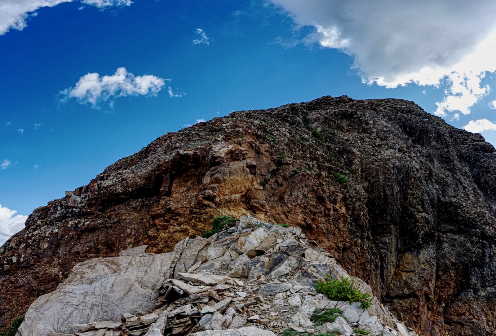
The rough and splintered east ridge of Hermosa Peak rises above lush meadows and a thick conifer forest. The Colorado Trail offers an otherwise-missed perspective on the south slopes. (Thomas Holt Ward, photo)

Route: The Colorado Trail (CT) crosses Bolam Pass Road at elevation 11,100 feet. Walk southwest on the CT and cross over the east ridge runout. Stay on the trail as it curves around to the west side of the mountain. Ascend east off-trail to a saddle at 12,020 feet. Climb the southwest ridge, the only reasonable access route.

Bolam Pass Road skirts around the east side of a reflective lake. We were delighted to see a cluster of salamanders swimming in the lake.

The Colorado Trail passes through the parking lot at 11,100 feet and heads southwest. Thru-hikers were camped in the trees when we launched into the woods.

The pathway winds briefly through a healthy fir forest. Trees part and the world expands on an open hillside, the La Platas off in the distant south. The Colorado Trail is a mini-shelf with a perfectly flat platform suspended 1,000 feet above Hermosa Creek. It is understandable why thru-hikers cross the entire state on this thin thread.

See Hermosa Peak for the first time at half a mile.

Walk through a chunky boulder yard. (THW, photo)

Reach the east ridge outflow at one mile, 11,540 feet. We left the trail to see about climbing the peak via the east ridge. It looked viable on the map but a crunchy beginning on unstable rock led up to a vertical-walled notch.

One of the best features along this route is the meadowland segment that follows. The trail here is right on the boundary between the subalpine and alpine. Robust trees frame thick swaths of tundra moistened by watery terraces and meandering rivulets. Marsh marigolds and glistening buttercups arise from snow fields and then yield to row upon row of corn husk lilies. Above it all stands conspicuous Lizard Head. (THW, photo)

The CT works the talus-tundra interface along the north flank of the mountain. (THW, photo)

There is a signed junction at 1.7 miles where the standard route joins the Colorado Trail. The parking lot at the end of FSR 149 is quite close.

The CT turns southwest on an old roadbed and gives up a small amount of elevation as it curves around to the west side of the mountain. The next objective is to determine the best place to launch off-trail for the saddle and summit ridge. We overshot this location on our way up and nailed it on the return. At 2.6 miles, almost 11,480 feet, a streamlet crosses the track. This is just before the terminal embankment of a rock glacier. The saddle is an easy climb east from here on green ramps. Below, Point 12,180' is southwest (right) of the saddle. We built a cairn at this juncture.

Below is a better shot of the route taken in 2023.

As an aside, we stayed on the trail another 0.2 mile waiting until we could see the peak. Additionally, we hoped to climb Point 12,180' on our return and wanted to check out the route back to the trail. We traversed this boulder field back to the recommended route.

This image looks back on the best ascent route from the CT. (THW, photo)

There are some trail fragments but they are teasers. It is a shallow climb to the saddle at 3.0 miles, 12,020 feet.

In 2007, I climbed Hermosa Peak by way of Point 12,180', shown. If that interests you see the note at the end of this post. (THW, photo)

A distinct trail plows up through chipped rock to the crux.

The Class 3 wall is a ten-foot climb with solid holds; test for them. There is mild exposure and some hikers will appreciate a spot. The ridge is broken so hikers are forced onto the west slope of the mountain for about 100 feet of elevation gain. It is very steep with a ball bearing surface and moderate exposure. A slip would be grave; self arrest not a guarantee. We were fortunate that the ground was damp. The climb would be sketchy if sun-baked. (THW, photo)
The linear summit ridge narrows a bit near the top but is a comfortable width throughout.

Crest the small summit cone at 3.4 miles. We were pleased at the breadth of the view circle. To the east is the slender backside of Engineer Mountain playing opposites with the tabletop that never ends on Graysill Mountain.

Directly below the mountain is the tundra expanse we walked across moments earlier. The drama up high is Sheep Mountain, San Miguel Peak, Grizzly Peak, and Rolling Mountain.

Northwest is Lone Cone, the westernmost peak in the San Juan Mountains; Dolores Peak; the Wilson fourteeners; and Black Face in the Lizard Head Wilderness. In the foreground is Flattop Mountain, accessible from Bolam Pass Road. (THW, photo)

Southwest are the Rico Mountains: Blackhawk Mountain and Harts Peak. (THW, photo)

Wildflowers were late bloomers in 2019 after a long, wet winter. The tundra was in full bloom during our visit. Here is a list of the 45 blossoming plants I saw on this little trek: marsh marigold, globe flower, alpine avens, mountain parsley, heart leaf arnica, Indian and rosy paintbrush, death camas, parrot beak lousewort, draba, Geyer's onion, clover, wallflower, bluebell, Western and edible valarian, salsify, king's and queen's crown, Jacob's ladder, purple violet, pussy toes, sage and snow buttercups, candytuft, brookcress, Parry's primrose, phlox, columbine, moss campion, potentilla, minuartia, purple fringe, smelowskia, snowball saxifrage, northern rock jasmine, geranium, drummond rockcress, native honeysuckle, strawberry, Whipple's penstemon, delphinium, and ball-head waterleaf. Happily tucked in the rocks on the west slope of the mountain was the outlandish Colorado ragwort, ligularia soldanella, with its distinctive thick purple leaves and over-sized flowerhead. (THW, photo)

Jeeps crept over Bolam Pass, 11,433 feet, while children looked out from the rim of the viewing platform.

2007 Route Over Point 12,180'
We hoped to climb Point 12,180' from the saddle and drop west back to the CT but the weather was too ominous. In 2007, we parked off Bolam Pass Road (east side) across from Grassy Creek at 9,400 feet. We pitched northwest to Spanish King No. 1 Mine. Next, we climbed the south ridge of Point 12,180'. My notes indicate it was "steep but easy." The northeast ridge of Point 12,180' was loose with lots of sliding rocks and quite narrow in places. I advised against this route for people with exposure issues. After climbing Hermosa Peak we did a "quick slide from the saddle" east into an unnamed west fork of Hermosa Creek, intersecting FSR 578 1.5 miles above the vehicle.
2 comments:
As usual... great write up Debra :) You make enjoying the San Juan mountains so much easier. Thank you.
I did this hike/climb with my son and pup. We did this before the rains came and the section above the crux was like marbles. No problem for the dog, but for us humans, way more challenging the wall. Regarding dogs... my girl was able to go straight up the wall... but she's a pretty good climber. The rock is a little smooth for a little part of it, so could be difficult for some dogs that aren't used to climbing rock. But, for those with dogs used to climbing... go for it.
Your rock cairn by the CT was gone... so I rebuilt it. But assume it will be gone by next year.
One other note... I decided to start further up in the meadow. It cut off 3ish total miles... which for me was nice... bad knees. For those looking for the shorter route... continue on Bolam Pass road for about 2.2 miles from the lake. Turn left onto FSR 149... there is a drainage right before the turn. Take FSR 149 until it dead ends. The road actually continues... but it's been permanently blocked off. Hike the road until in connects with the CT (about .5 mile).
Thank you for this superb and helpful comment. I agree, the open slope above the crux is the sketchiest part of the climb. You have a brave dog and son. Thank you for rebuilding the cairn. And yes, starting from the end of FSR 149 is a totally legit shortcut. Thanks for the memories. Debra
Post a Comment