Travel: The trailhead for the Cross Mountain Trail is located on the west side of CO 145, two miles south of Lizard Head Pass at mile marker 57.4. Watch for a brown US Forest Service sign directing into a large parking lot. No facilities, no water.
Distance and Elevation Gain: 12.8 miles; 4,100 feet of climbing; if you do the thru-hike to Lizard Head Pass and have a shuttle you save two miles.
Total Time: 6:30 to 8:00
Difficulty: Primarily Class 1 trail, some off-trail; navigation moderate; some exposure on the optional southeast ridge of Lizard Head; Class 2+ scramble up the Black Face outcrop, an add-on.
Maps: Mount Wilson, Colorado 7.5' USGS Quad or, Trails Illustrated 141: Telluride, Silverton, Ouray, Lake City
Latest Date Hiked: July 29, 2018
Poem:
How wonderful is Cold Mountain
Climbers are all afraid
The moon shines on clear water twinkle twinkle
Wind rustles the tall grass
Bare twisted trees have clouds for foliage
A touch of rain brings it all alive
Unless you see clearly do not approach.
Han-shan c.800
Lizard Head, a vertical pillar of exfoliating rotten rock, is Colorado's most difficult and dangerous thirteener--the easiest route is class 5.8. Albert Ellingwood and Brandon Hoag made the first ascent in 1920. This image was captured from the summit of Black Face under a brooding sky. (Thomas Holt Ward, photo)
Route: The hike described is the black-line route. Ascend north on the Cross Mountain Trail. At the junction with the Lizard Head Trail go northwest to intersect the west ridge of Lizard Head. Pitch up a climber's trail to the base of the tower. Descend on the southeast ridge back to the Lizard Head Trail and walk east to Black Face. Return to the Cross Mountain Trailhead. Or, continue east on the Lizard Head Trail to the pass (blue-line route) and your shuttle vehicle or bicycle. It is a 2.3 mile walk down the old railroad grade back to the start.
Cross Mountain Trail #637 (CMT) initiates at the confluence of Lizard Head Creek and Snow Spur Creek, a north tributary of the Dolores River. The trailhead (pictured), elevation 10,040 feet, is in the center of one of Colorado's most extensive and beautiful meadowlands. Sign the trail register, cross a narrow bridge and rise up out of the headwater valley.
Lizard Head and the Black Face summit and outcrop are visible from the valley floor. (THW, photo)
The first 2.5 miles are thickly wooded with interspersed clearings. The Groundhog Stock Trail branches left at 0.6 mile. From here, the CMT is open to equestrians and hikers only. The packed earth and weathered stone path maintains a consistent gentle grade. Enter the Lizard Head Wilderness at 1.9 miles, 11,200 feet.
The trail levels out for a welcome reprieve as our quest draws near. The path flanks west of Point 12,038'.
Upon entering the capacious world above the trees the highest peaks in the San Miguel range announce themselves: Wilson South, Mount Wilson, Gladstone Peak, and Wilson Peak. Cross Mountain is in the foreground.
The CMT ends at a signed junction with Lizard Head Trail #505 at 3.3 miles, elevation 11,940 feet. Turn right if you are doing the standard thru-hike to Lizard Head Pass. (THW, photo)
Lizard Head Platform
Turn left for the easiest route to the Lizard Head platform via the west ridge where there is a considerable break in the cliff band encircling the earth pillar. (THW, photo)
The Lizard Head Trail crosses the saddle between Cross Mountain and Lizard Head, descends north through Bilk Creek Basin, threads between Wilson Peak and Sunshine Mountain, and terminates at the Wilson Mesa Trail. Leave the trail at 3.7 miles, about elevation 12,060 feet, and cut up to the west ridge.
A thin climber's trail will materialize at 12,200 feet. The unmaintained track makes short switchbacks in broken gray rock up the steep and narrow spine. Having seen Lizard Head from dispersed mountains over the years it was a startling and powerful sensation to approach the base of the monolith. The standing rock exudes a strong presence.
Mount the platform at 4.1 miles, 12,780 feet. The terrace is sloping and covered with stones of every size that have flaked from the tower which rises vertically overhead. Lizard Head is notorious for exfoliating in the presence of humans. Do not tarry beneath this beautiful structure.
As we rounded the corner we watched a father and son team whom we knew rappel a south wall crack at the completion of their successful climb. It was a rare and chance privilege to share this celebratory moment.
The southeast ridge descent to the Lizard Head Trail is more difficult and exposed than the west ridge. It is a route, not a trail. If you have doubts, return the way you came. For the southeast route, walk under the south face of the column. (THW, photo)
Scrutinize the Class 3 winter snow route up the east face of Mount Wilson from this vantage point. (THW, photo)
There is only one weakness in the ramparts girdling Lizard Head on the southern slopes. This image was taken from the Lizard Head Trail shooting up at the descent route. (THW, photo)
A cairn marks a bypass around an orange knob. Leave the ridge at 12,560 feet and work your way down the slope threading through breaks in the cliff faćade. Drop 200 feet on a slippery surface comprised of San Juan explosive volcanics. There is some exposure. The grassy hillside leads directly to the Lizard Head Trail.
San Bernardo Mountain and Black Face are in the foreground vista. (THW, photo)
The downward plunge requires patience and nerve. (THW, photo)
Meet back up with the Lizard Head Trail at a beautiful overlook at 4.6 miles, 12,100 feet. If you backtracked down the safer west ridge it is only 0.6 mile further to this point.
Black Face
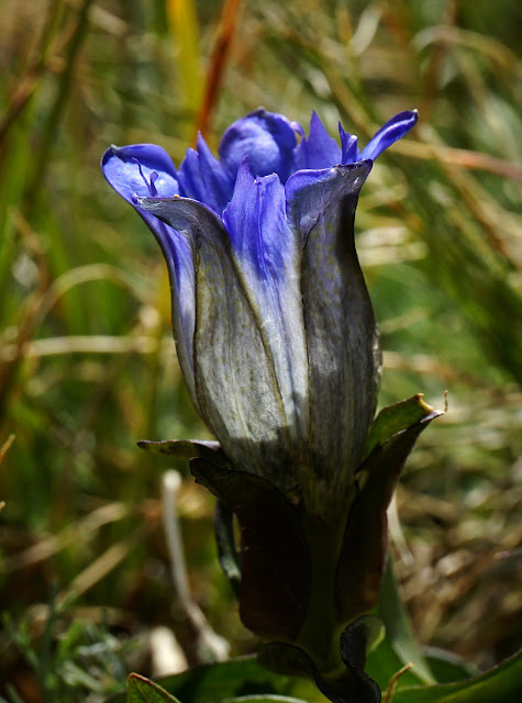
The trail gives up over 500 feet in the next mile. It crosses open tundra and then does a long sweeping switchback to bypass a rocky slope. In August, blooming beside the trail there will be a superb display of star, arctic, and bottle gentian. (THW, photo)
Bottom out in the saddle at 5.7 miles, 11,500 feet. This is a principal divide with water flowing north to the South Fork of the San Miguel River and south to the Dolores River. Enter a healthy conifer forest and start climbing.
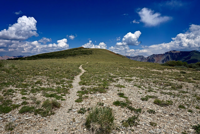
The trail doesn't deviate from its eastward orientation. At 11,900 feet emerge into the big open, the peak visible straight ahead. (THW, photo)
Reach the highpoint of the Black Face ridge at 6.8 miles. You may well have some company somewhere along this accessible and spectacular divide. For two full miles you will be hiking on a smooth trail above tree limit. In this image, hikers are standing on the summit. Over the lengthy Yellow Mountain ridge are South Lookout Peak, V3, and US Grant. (THW, photo)
For thru-hikers, it is four miles down to Lizard Head Pass. One of the great features of that route are the west-side views of peaks typically reached from Ice Lake Basin: Pilot Knob, Golden Horn, and Vermilion Peak. Beattie Peak and V8 bridge to San Miguel Peak and Sheep Mountain.
It is six miles from the summit back to the Cross Mountain Trailhead. Walk 0.1 mile west to the Black Face outcrop.
It is a thrilling add-on to cross a short and safe ridge before doing a Class 2+ scramble to the top of the suspended buttress. (THW, photo)
On the return there is a 0.3 mile trail segment not yet walked just before the junction with the CMT. Black Mancos shale blanketing the southern slopes of Lizard Head contrasts sharply with bright green elfin timber in the krummholz.
(THW, photo)


No comments:
Post a Comment