Travel: From Telluride, FSR 204A is exactly two miles (the first left), south of Lizard Head Pass off CO 145, mile marker 57.6. From Dolores, as you near Lizard Head Pass, the popular Cross Mountain Trailhead is left/west of the road and the East Fork Trail is on the right/east. Drive another 0.1 mile and turn right/east on the next dirt road, FSR 204A. Trailhead parking is half a mile up the somewhat steep track, embedded with ruts and rocks. Most 2WD vehicles should be able to reach the trailhead.
Distance and Elevation Gain: 9.0 miles; 3,325 feet of climbing
Time: 5:00 to 6:30
Difficulty: Trail, off-trail; navigation moderate; steep slope; short scramble with considerable exposure on the optional gendarme
Maps: Mount Wilson, Colorado 7.5 Quad preferred; or, Trails Illustrated 141: Telluride/Silverton/Ouray/Lake City
Date Hiked: August 12, 2015
Reference: If you wish to climb the more challenging north ridge route from Lizard Head Pass consult Telluride Trails, by Don Scarmuzzi.
Quote: Life is best organized as a series of daring ventures from a secure base. John Bowlby
Sheep Mountain from the East Ridge Gendarme. Just feet from the summit, the east ridge transitions from ordinary to astounding. (THW, photo)

Route: Walk southeast on a dirt road for 2.0 miles. Cross a wetland meadow and turn northeast to follow a drainage to the rounded but steep west ridge of Sheep Mountain. Gain the north ridge. Climb south to the summit. Continue 0.4 mile on the east ridge to the gendarme. Note, 2020: Please see the comments at the end of this post about private land infringement.
From Trailhead 10,180', go around the gate and walk southeast on the road that goes to High Camp Hut. Access is open to hikers. The track climbs through a thick fir forest with occasional views of Sheep Mountain, shown, and the Lizard Head Wilderness.

At 1.9 miles, take the left fork. In two miles, a stockade is visible right of the road in conifers, shown. The High Camp Hut is nearby. Leave the road at 11,000 feet.

Cross a boot-drenching, soggy meadow. Penetrate the trees on the other side at the obvious break, shown. The passage leads directly to an abandoned road. Turn right/east.

At around 2.4 miles, 11,300 feet, leave the road and walk overland to the creek. Walk northeast up the stream course. The drainage splits the difference between the base of Sheep Mountain and a lesser hill to the west. The heavy woods soon part and you will be on an open incline. Follow it to treeline at 11,750 feet, 3.4 miles.
The image below was taken just shy of timberline. It shows the north ridge of Sheep, its crest hidden behind the conifers, image-right. The west slope is very steep; climb 1,100 feet in 0.47 mile. The gentlest line is just to the right of the minor cliff band, center-left. The footing is stable on grassy tundra platforms.

Gain the ridge at 3.8 miles, about 12,800 feet. The vista is outrageous. This image captures the Lizard Head Wilderness beyond CO 145.

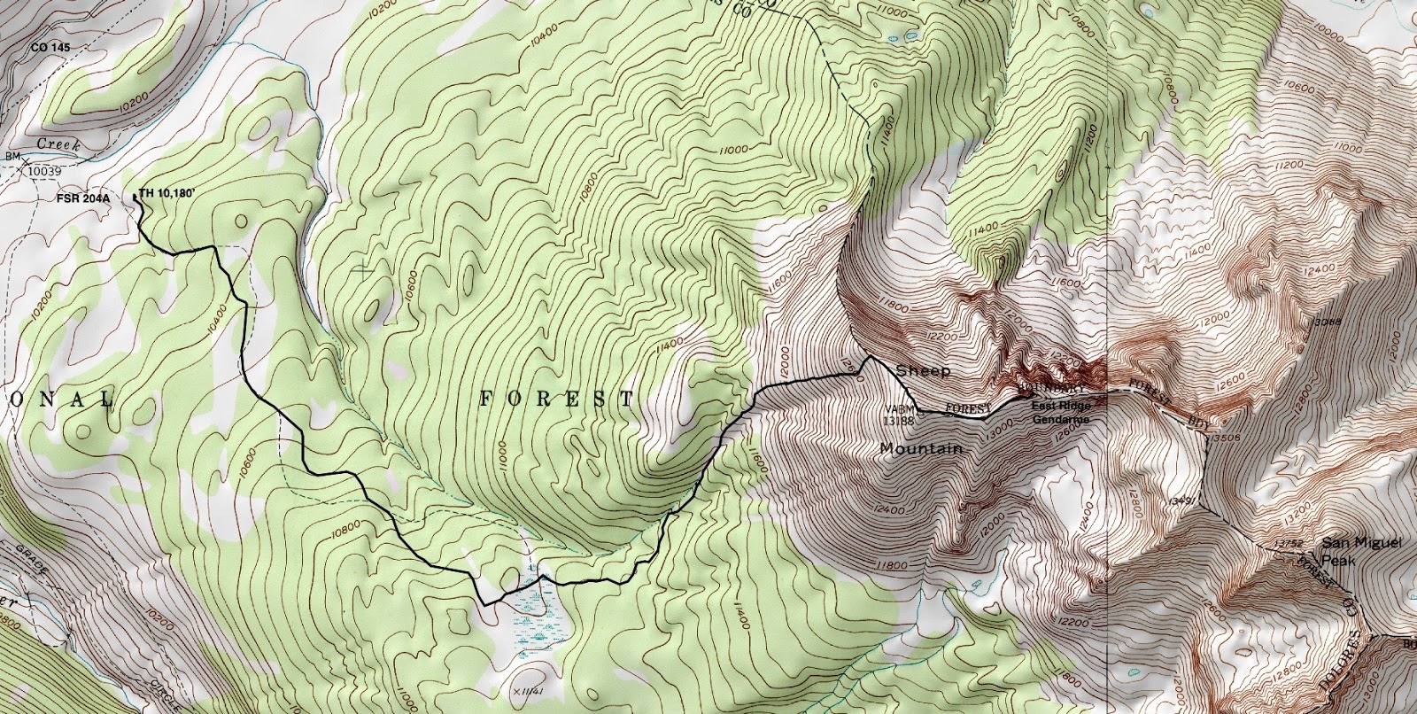
It takes awhile to process the scenery on the east side. Below, image-left, are peaks at the head of Ice Lake Basin: Pilot Knob, Golden Horn, Vermilion Peak and Fuller Peak. Image-center is the East Ridge Gendarme.
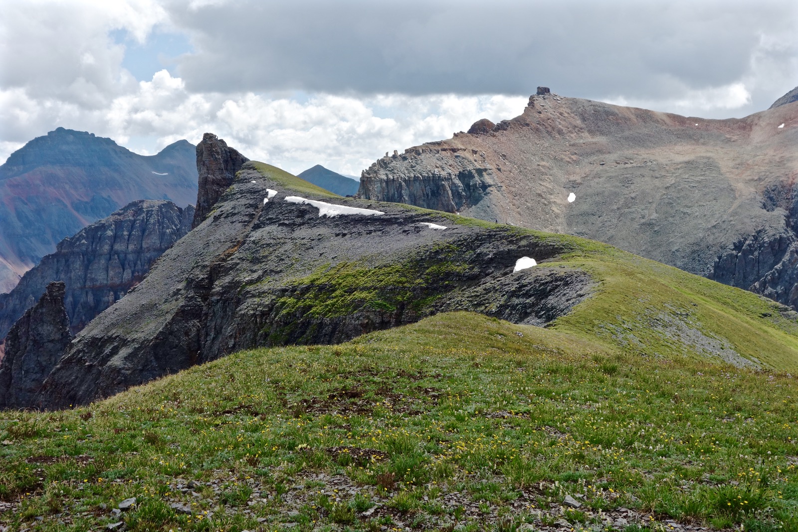
The east side of the north ridge drops off profoundly. Walk up the tundra and an easy talus slope to the rounded peak at 4.1 miles.

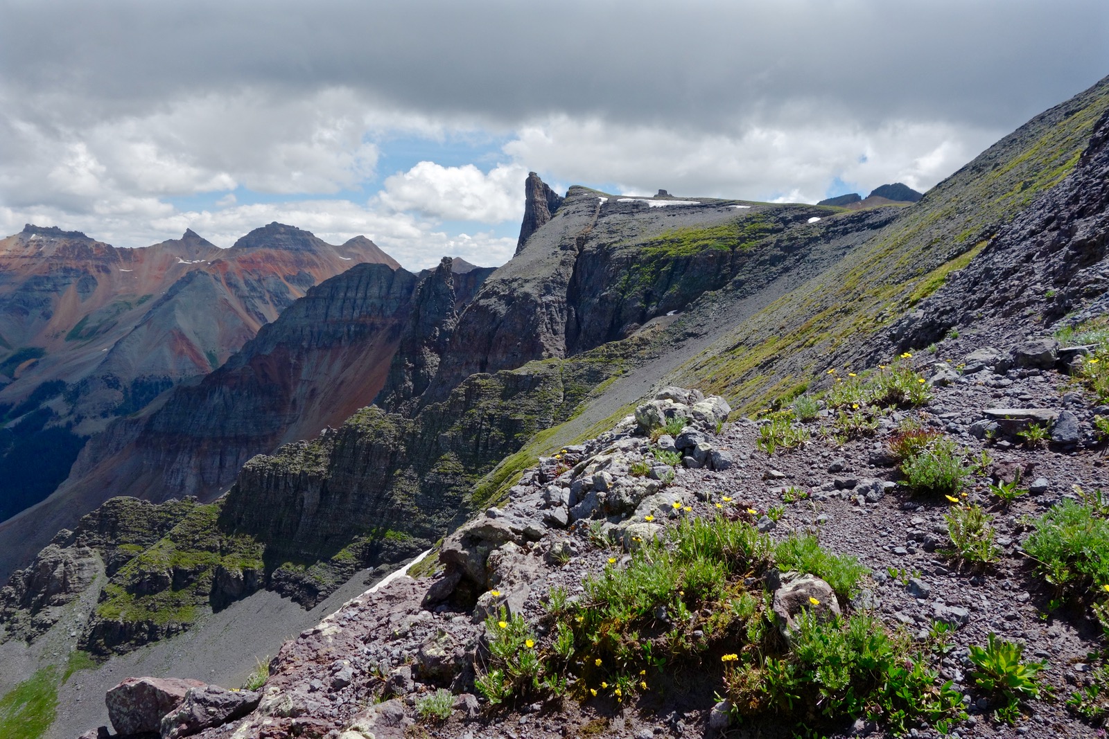
Not to discredit Sheep Mountain, but the best part of this hike is yet to come. Even if you have no intention of climbing the gendarme, walk on the east ridge as far as you dare. It drops vertically on the north side and slips ever more steeply to the south. Click on the image below to see a climber on the gendarme.
Deep cracks are even now opening at the edge of the ridge and swallowing earth into Oblivion Couloir. Ogle over the side and it feels like you are staring into the planet's iron core. Needless to say, this is an exciting, even hair raising, precipice. (THW, photo)

I catch sight of a happy, crazy friend on the zenith of the gendarme.

The approach to the base of the gendarme at 4.5 miles on San Juan volcanics is scrabbly. The pinnacle is higher than Sheep Mountain at 13,340 feet.

I climb the volcanic spire and stop short of the top at a six foot summit boulder. (THW, photo)

The boulder's obvious step-up rock is loose and ready to let go. Climbers must go around the boulder on the left/west side, shown. This image doesn't capture the problem. You must make an airy move with poor hand holds on a loose-rock base a few inches wide. The drop is 740 vertical feet.The exposure is breathtaking. Three of my friends made it. One who demurred calls it the Darwin Award Pinnacle.

Point 13,506' is 0.6 mile east of the gendarme on the ridge to San Miguel Peak, just off image-right. Two friends walked east to explore the first gash in the ridge. They concluded that climbing San Miguel from Sheep Mountain is unlikely.

Return as you came. Lizard Head, the region's sentinel, keeps eternal watch over hikers crossing the wetlands.

My gratitude to Dan for showing me this route.
6 comments:
Just wanted to say that we hiked this trail yesterday and many of the steps from this page are blocked off purposefully by downed trees. Part of the hike is through private land and the landowners have decided that while they don't mid people hiking through their land to the base of Sheep, they don't want them in view of their house and their rental property (the huts). You will have a hard time hiking this peak (like we did) if you try to follow the directions exactly as the say on this page as many of the steps are hard to find under downed trees. (Source)I spoke with the owner on the hike down, she was very nice.
Thank you for your cautionary comment about my route infringing on private property. I was unaware. It appears that the track crosses private land between 1.8 and 2.6 miles. Hikers are advised to research ahead of their climb and skirt the private land on the north. Debra
Hi Debra,
We would like to add that your blog is extremely helpful and we appreciate all the time you take in leaving such wonderful directions! My partner and I are thinking of attempting this mountain in a few days...we're probably not going to be climbing the gendarme, though!
Thank you for reading. See the 10/5/20 and 10/8/20 comments. I'm hoping it won't be too difficult to skirt the private land. Enjoy your climb. Debra
Debra, we did this hike again this July. As always, your detailed descriptions of routes were so helpful! We love your blog.
We’d like to add that someone hauled a big ladder and left it by the Gendarm (?) I guess it’s to help climb across the cavern?!
Second time up! That's awesome. I'm pleased the blog is useful for you. I do hope that the Forest Service or some good samaritan removes the ladder.
Post a Comment