Travel: Shuttle required from Hirabayashi Trailhead to Bear Canyon. In Tucson, drive east on Tanque Verde Road and turn left on the Catalina Highway. Drive past Molino Basin and turn left in 11.7 miles at the sign for Gordon Hirabayashi Recreation Area. Drive through the campground (tables, fire grates, food boxes, pit toilets, trash, no water) and drop a vehicle at the trailhead in 0.3 mile. Zero-out your trip meter. Turn right on the Catalina Highway (aka General Hitchcock Highway) in 0.3 mile. At 8.3 miles, turn right/west onto Snyder Road, the first stop sign. In 11.0 miles, turn right on Bear Canyon Road. Make a 90 degree left turn onto a dirt road at 11.4 miles. The road can be lumpy but driven carefully, most vehicles should reach the Bear Canyon Trailhead in 11.5 miles. New in 2020: If you are taking the blue-line route to Gibbon Ridge, from the 4-way stop at Harrison and Snyder roads, turn right/north on Bowes Road. Past Sabino High School, Bowes turns to gravel. Park in the lot at the end of the road without blocking the driveway on the right.
Distance and Elevation Gain: 8.1 miles; 3,840 feet of climbing
Time: 6:00 - 7:30
Difficulty: Almost entirely off-trail; navigation challenging; Class 2+ with mild exposure; no dogs; carry all the water you will need
Maps: Sabino Canyon; Agua Caliente Hill, AZ 7.5 Quads, or Pusch Ridge Wilderness, Coronado National Forest, USDA Forest Service, 1:24,000
Date Hiked: March 17, 2016
Quote: For bighorns, topography is memory, enhanced by acute vision. They can anticipate the land's every contour--when to leap, where to climb, when to turn, which footholds will support their muscular bodies. To survive, this is what the band would have too do: make this perfect match of flesh to earth. Ellen Meloy
The southwest ridge of Gibbon Mountain from Saddleback Ridge. (THW, photo)
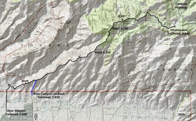
Route: From Bear Canyon Trailhead at 2,660 feet, enter Sabino Canyon Recreation Area and then locate the base of Gibbon's southwest ridge. Stay on or near the ridgeline to the summit. Descend east to meet the Arizona Trail and take it to the Hirabayashi Trailhead, 4,840 feet. See the end of this post if you wish to take the blue-line route from the Bear Canyon Lookout Trailhead to Gibbon Ridge.
Pass into the Coronado National Forest and Sabino Canyon Recreation Area at 0.5 mile.
Turn right on the paved road walking toward the mountain. Stay on the road where it meets the Seven Falls Trail. This is the last opportunity for bathrooms and water. While walking up the road, devise a plan for getting onto the ridge; there is no perfect or cairned way. We left the main road at 0.9 mile and turned right onto a secondary dirt road. Cross Bear Creek and bash through brush to the run-out of the cliff formation. At 1.1 miles start up the ridge, a spur that avoids private property on the main. The two join shortly and seamlessly.
Gibbon's ridge is immediately captivating for its ease of travel and perspective. Walk on rimrock; plant annoyance is minimal all the way to the summit. The divide slopes off on the right into a deep unnamed drainage, and cliffs out on the left. The best walking is along the edge overlooking Bear Canyon. The voices of hikers on the Seven Falls Trail are easily heard as is Bear Creek.
Just before Pt. 3,250' on the topo, at 1.4 miles, look directly through a hard-rock, rectangular buttress arch.
By 4,300 feet, saguaros are replaced by grassland cast in a purple haze from flowering Santa Catalina prairie clover. The ridge bends east at a promontory at 4,570 feet before resuming its northeasterly trajectory. Take in a unique vista of the iconic Santa Catalina divide originating at the base of Blackett's and terminating in Sabino Basin. Saddleback Ridge to Point 5,001' is compelling and rightly so.
Further along, the precipice affords an extraordinary perspective on Seven Falls, upper Bear Canyon, and Thimble Peak.
The next goal is Pt. 4,892', image-center, where we will plot our summit course through this somewhat convoluted landscape. The companion crest of Gibbon Mountain is left of center.
Along the way we find a gigantic, golden Mariposa lily and an uncommon purple twining snapdragon. (THW, photo)
At 4.4 miles, reach Pt. 4,892', the first opportunity to study the mountain. We decide on an approach that we had not tried--to hold our bearing right up the spine. This proved to be delightful and expeditious.
Lose 150 feet then gradually climb to 5,000 feet. The approach is over. The last 800 feet is troubled with cliffs and gendarmes. However, these may all be bypassed on the right/southeast. (By 2025, a social trail had developed on a good route very close to ours described here.) The first set of cliffrock looks imposing so contour to the right into an excellent climbing declivity. It is steep but not ridiculous and there are plenty of big leverage rocks.
Return to the ridgeline at 5,200 feet. Go directly up the spine; skirt the next gendarme on the right and then pitch up a very steep slope regaining the backbone at 5,480 feet.
Repeat this pattern and then come to the last rock face, starkly beautiful and lichen covered. Scale it directly for some distance before detouring to the right one last time, pictured.
Top out on Gibbon's false summit (Gibbon #1) at 5.7 miles, 5,780 feet. After the long and lovely approach, the obstacles on the 800 foot high-angled incline added a sense of sparkle and genuine pleasure. It is so satisfying to remain true to the ridge. The image below was shot from the subsidiary summit. It shows the Bear Canyon trench flowing into Tucson and the ascent ridge stepping down.
Stroll over to the true summit, reaching it at 6.1 miles. Gibbon Mountain is double-humped; the first/west projection is slightly higher. Weathered granite provides good seating. This is one of the few high forward peaks in the Pusch Ridge Wilderness and the vantage point is far-and-wide. East is the Catalina Highway. Swing around clockwise to see Agua Caliente Hill (looking like a real mountain), the Rincon Mountains, Santa Rita Mountains, Elephant Head, Baboquivari Peak, Tucson Mountains, then Mount Kimball, Window Peak, Cathedral Rock, and Mount Lemmon.
Total climbing to this point is 3,740 feet. If you did not shuttle a vehicle, return as you came, or drop to Shreve Saddle and go back via Sycamore Reservoir and Bear Canyon trails, a long haul. I advise against dropping directly from the mountain into Bear Canyon. My climbing partner did that and barrier walls are dangerous and present navigational challenges.
It's pretty amazing to have a car parked two miles from the summit. Downclimb off the double summit block then ascend a delightful, rocky ridge to the next promontory at 5,620 feet, shown image-center. There is a hint of a social trail near twin standing-up rocks but the route is too bouldery to encourage a path.
The mountain shows little sign of visitors. However, of those who do climb, most start from the Hirabayashi Trailhead. While there is no standard route, there are some wonderful descent alternatives described on the internet. Our route hits the Arizona Trail at first opportunity, Shreve Saddle and the wilderness boundary. From the promontory at 5,620 feet, head southeast on the ridge and then do a steep downclimb east to the saddle, hitting it at 7.1 miles. Turn right/southeast on the Arizona Trail, a two track. The image below looks back to the final knob above Shreve Saddle, just off-image to the right. A shallower descent comes off to the southeast.
Arrive at the Gordon Hirabayashi Trailhead at 8.1 miles, 4,840 feet. Along the Arizona Trail, this is Passage #11, The Santa Catalina Mountains, covering Hirabayashi to Romero Pass in 11.7 miles.
The parking area is on the other side of a corral.
We identified 23 flowering plants, a fraction of the bloomers out there in March. Desert sand verbena is a common plant in the Sonoran. On this trip I discovered that if you put your nose into the plant its fragrance will alter your state of consciousness...for the better!
I wish to credit my companion who pioneered this route up Gibbon Mountain.
2020 Revision: Bear Canyon Lookout Trailhead
The blue-line route will please everyone except those who want to hike the entire Gibbon Ridge. From the trailhead, elevation 2,820 feet, ascend north on an easement enclosed by fencing. Cross into the Pusch Ridge Wilderness and climb on a maintained trail up a south-facing ridge. The trail ends at Bear Canyon Lookout, 3,380 feet, on Gibbon Ridge after 560 feet of climbing over half a mile.
The blue-line route will please everyone except those who want to hike the entire Gibbon Ridge. From the trailhead, elevation 2,820 feet, ascend north on an easement enclosed by fencing. Cross into the Pusch Ridge Wilderness and climb on a maintained trail up a south-facing ridge. The trail ends at Bear Canyon Lookout, 3,380 feet, on Gibbon Ridge after 560 feet of climbing over half a mile.
Distance and Elevation Gain: 5.0 miles; 1,500 feet of climbing
Total Time: 3:00 to 4:30
Difficulty: Trail, primarily off-trail; navigation challenging; Class 2+ with mild exposure
Map: Agua Caliente Hill
Latest Date Hiked: March 14, 2022
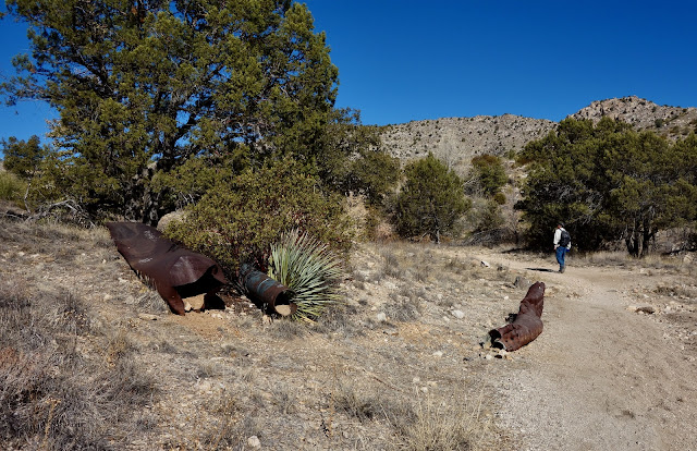
The hike starts out heading west on the Arizona Trail, elevation 4,840', and crosses the bridge over Solider Canyon at 0.2 mile. At 0.5 mile, an old trail bears west. This is 10 to 15 paces after the passing three rusted pipes, pictured.
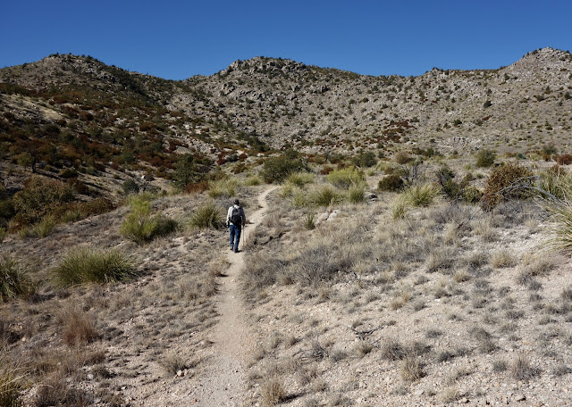
You won't find this trail on a map but it shows signs of frequent use. Point 5,420', the next objective, is image-left.
The track segues to a braided social trail at about 0.8 mile. The paths wander up the east slope of Point 5,420'. Avoid the trail branching southeast toward Point 5,158' at 1.0 mile. Either tag the top of Point 5,420' or skirt it on the right, contacting its north ridge at about 1.3 miles.
Walk northwest on a short segment of clear trail composed of bedrock and crushed granite. Cross a short divide with a fork of Sabino Creek on the west and a tributary of Soldier Canyon on the east.
Pass a square-stack hoodoo.
Ascend into a draw with a grove of carbon black trees.
Hold a northwest bearing to the top of the draw and gain a ridge at 5,540 feet. From here, you can see Gibbon #2, and #3. Turn 90 degrees to northeast and head a drainage. (This is where our route overlaps with the thru-hike from Bear Canyon.) Swing around to the west and onto the lengthy Gibbon Mountain summit ridge at 5,620 feet.
A sporadic social trail graces the ridgetop, wandering to and fro between rock stacks. My favorite is the best-friends-forever hoodoo duo.
Gibbon Mountain has three prominences, all quite different. Visit them all! The eastern summit is the gnarliest. Clamber up the rock pile to perch on Gibbon #3 at 2.0 miles, 5,780 feet. The register is buried in the cairn stack. The high vista captures Cathedral Rock and Mount Lemmon, and well below is Sycamore Canyon and Reservoir.
There is a short section of mild exposure on the 0.1 mile traverse to Gibbon Mountain, aka Gibbon #2, the highpoint at 5,801 feet. Be sure to continue 0.4 mile to Gibbon #1. You'll loose 180 feet and climb another 160 on bedrock and resurrection moss. Not only does the outpost have the best views, it has an entertaining peak register. The 70+ IPA Club wrote, “2 bad boys, 2 good dogs, 10 beers, nice.” Look directly down on Bear Canyon and over to Gibbon's sister ridge where vertical shafts hold up Thimble Peak, and Saddleback and Blacketts ridges.
We altered our route on the return, going over Point 5,158' and looking into the beautiful (and vertical) Soldier Canyon gorge. A social trail goes as far as Point 5,158' and then disappears. It was rewarding but a more difficult choice than simply retracing steps.


6 comments:
Interesting, I'll probably try this. I've been to Gibbon from the Gordon Hirabayashi side, and I agree that it is very lightly traveled. There's one cairn marking a turn from the main Arizona Trail, then a faint trail that gradually dissolves.
I did two scouting runs for this hike. 1: Started at Sabino Canyon parking lot, walked up Bear Canyon tram road and looked for a place to scramble up the ridge. I was alone and didn't give myself enough time, so I didn't attempt it. It looked possible, but overgrown. 2: Started from Bear Canyon Overlook Trail (Bowes Road). This got me to the ridge easily. I wanted to see the arch, so I went downridge, bit of bushwhacking but doable. Spectacular views.
I plan to return and go to Gibbon, then out at Hirabayashi.
Hi, Debra. It took me way too long to finally finish this hike, but I've done it now. If you're interested, please see https://daringdayhikes.home.blog/2024/08/24/secondary-trail-tertiary-trail-no-trail/
Also, I watch a YouTube channel called "SUV RVing". He mentions your book in https://www.youtube.com/watch?v=FP2-KqQEmqk at 15:37.
Great to hear from you, Larry. I'm happy you made it up Gibbon, no easy feat. Your delineation of the different types of trails is the best I've ever read. As for the SUV RVing video, it's super sweet he mentioned our book. Curious about the Amazon delay. It's selling briskly at Maria's Bookshop in Durango, but they always have it in stock.
We went up from Hirabayashi today, following more or less the same route as we had done in 2018, which also aligns closely with your black route. At this point there is a clear social trail well past 5420 and if you keep your eyes open, all the way to the summit. It is lightly cairned in places during the ascent up to the summit ridge as well. I don't mean to imply that there is always an obvious tread, but if you can read the ground you'll find it.
Thank you for the update, Chris, and for doing your part to keep the blog alive and accurate. Debra
Post a Comment