Travel: From I-10, take Exit #297, Mescal Road. Zero-out your trip meter and drive north on Mescal Road, a paved two lane. Pavement ends 3.2 miles from the interstate. Transition to FSR 35 at 4.3 miles. It is a graded, wide, flat roadbed prone to washboard. Wind up Ash Creek which drains the Little Rincon Mountains on the east and the Rincon Mountains to the west. Pass Ash Creek Ranch at 7.2 miles. If the washes aren't running, a 2WD with decent clearance should reach the trailhead. However, in March, 2016, we forded Ash Creek four times. The first and deepest crossing at 8.1 miles required 4WD with high clearance. Enter Happy Valley at 15.5 miles. At 15.8 miles there is a sign for the Miller Creek Trail pointing left. Go left at the first fork and park at the trailhead, 16.0 miles and 45 minutes from I-10.
Camping: There is shaded, dispersed primitive camping along FSR 35. We found a peaceful camp with an excellent view of Rincon Peak near the trailhead amongst oak and sycamore trees. Early sun. Bring water. Bonus: a herd of horses came through camp in the deep night, beautiful in full moonlight. There is a fabulous backpacker's camp halfway up the mountain with undependable water.
Distance and Elevation Gain: 15.7 miles; 4,600 feet of climbing; carry more water than you think you will need.
Time: 8:00 - 10:00
Difficulty: Trail; navigation easy when free of snow; Class 2 with no exposure; no dogs
Maps: Happy Valley; Mica Mountain; Rincon Peak, AZ 7.5 Quads, or Trails Illustrated No. 237, Saguaro National Park
Date Hiked: March 22, 2016
Quote:
I love the joy of mountains
Wandering free with no concerns
Sometimes I climb a rock pavilion
To look down a thousand foot precipice
Overhead are swirling clouds
A cold moon chilly cold
My body feels like a flying crane. Han-shan (9th century)
Rincon Peak in clear morning light from the trailhead primitive camp.

Route: It's trail all the way. From Miller Creek Trailhead 4,200', walk west through Miller Canyon and enter Saguaro National Park. At the Happy Valley Saddle, go southwest on the Heartbreak Ridge Trail. Climb south on the Rincon Peak (spur) Trail to the summit. This is an out-and-back hike.

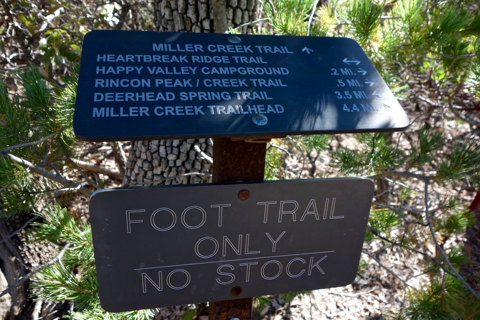
Two trails leave from the trailhead area; there is no mistaking the one you need. Open (and close) a barbed wire gate. The Miller Creek Trail sign is on the other side.

Shortly, cross Miller Creek, the first of several fords. Water level was inconsequential when we visited but could be problematic during run-off. The riparian warm-up is on a flat, smooth dirt trail through tall Arizona oak and sycamore; typical Sonoran vegetation is noticeably absent. There are no saguaros on the east side of the Rincons. Rather, soft golden hills are north of the creek and south are tree-covered slopes. The track takes aim at a prominent outcrop (image-center) east of Happy Valley Lookout on Heartbreak Ridge.
Pass by coarse grained intrusive granite boulders with chunks of discarded quartz scattered all around. The crushed granite path finally begins pitching up after a mile. Mileages on the signs are generous. At 1.34 miles, enter Saguaro National Park through a kinked fence and sign the register. Bikes and dogs must turn back here. The treadway, now in the oak woodland vegetation zone, plows through manzanita and madrone. It kicks up in earnest on spheroid steps; big old weathered boulders are everywhere. If you favor metamorphic granitic gneiss this climb is for you.

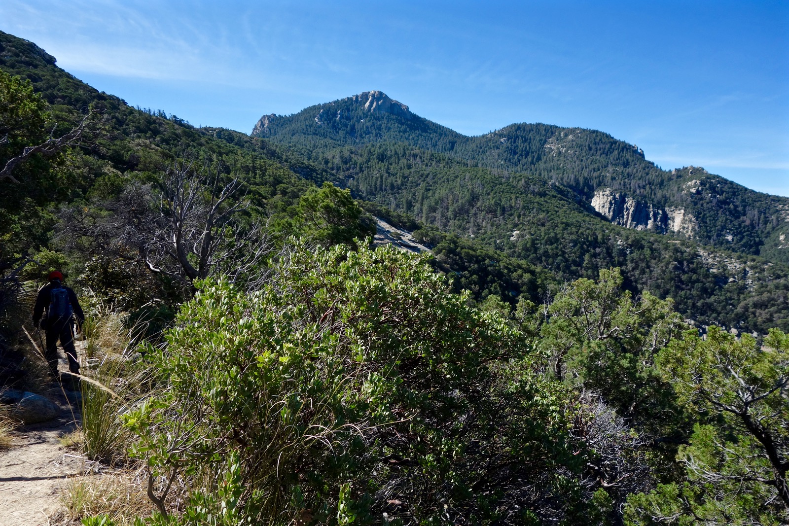
Turn south to skirt the rock outcrop at 2.3 miles on the first major switchback shown on the map. Keep a watchful eye as the track twists and turns all over, weaving around and up and over boulders, a great pleasure. The image below looks back to the sun powering up over the Little Rincon Mountains. (THW, photo)

At 3.3 miles, enter the Miller Creek ravine. The trail stays south of the stream, passing by a jumble of huge boulder balls.

At 3.8 miles, 6,100 feet, there is an excellent resting place on a granite slab overlook. Pictured is Happy Valley Lookout. (THW, photo)

The peak is revealed as you top Happy Valley Saddle at 4 miles, 6,160 feet.

Within a few paces, go left/south at the junction with the Heartbreak Ridge Trail.
The short spur into Happy Valley Campground is at 4.2 miles. This classic backpacker's camp shelters in a mature ponderosa grove. There is a vault toilet and spacious sites with bear boxes, fire rings, and log round furniture. We found some grungy water pooled below the campground. Don't count on treatable water. (THW, photo)

At 4.5 miles, the Rincon Creek Trail continues straight and we turn left on the Rincon Peak Trail. For most of the distance to the crest, the trail stays well off the ridge on the west side. Standing rock towers drill up from the dense alligator juniper forest. The trees are tall and massive with multiple trunks.
A contour reprieve gives way to the climb. While old, orange metal markers are tacked to trees, they are sporadic. This segment would be a navigational challenge if there was much snow.

Cross several small creeks and finally reach the ridge at 7.1 miles, 7,600 feet. This is not a conventional ridge hike. After just 150 feet of climbing the trail traverses to the east side. A few aspen struggle in a shady climax forest with huge conifers. The forest duff path bolts directly up a very steep slope for a good 400 feet. At 8,300 feet weave around and step over granite boulders; Class 2. The peak register is just shy of the summit.

Cresting the mountain at 7.8 miles feels like boundless exhilaration. Ravens dive bomb in the frigid windblast.

Rincon has the best view anywhere of Mount Lemmon, image-left. From here it is clearly the highpoint of the Santa Catalina Mountains. The granite summit falls precipitously off on three sides. This image looks north to Mica Mountain. This is a small, L-shaped range with three principal peaks. Rincon means “corner” in Spanish. The Mica Mountain dome, the highest eminence at 8,666 feet, sits at the vertex. Tanque Verde Ridge slopes westward, the south running Heartbreak Ridge climaxes at Rincon Peak.

Northeast is Bassett Peak in the Galiuro Mountains and Mount Graham in the Pinalenos. I let go of any notion of an off-trail return on Rincon's north ridge. The range is a highly eroded mass of bedrock and the ridge is riddled with towers.

The zenith is bigger and broader than it appears when seen from afar. This image looks toward Tucson and Tanque Verde Mountain. (THW, photo)

The wind hustles us off the peak before we've had our fill of top time. A community of claret cup cacti on the east side of the summit block are still in winter mode. But periwinkle wild hyacinth is blooming in the lower reaches and manzanita is clothed in profuse sticky pink blossoms. The grassland foothills of Rincon Peak are flowing folds of velvet in afternoon light. (THW, photo)

No comments:
Post a Comment